Confirmed Tornado Comes Very Close to Kansas City
Special Stories
28 May 2019 8:05 PM
On Tuesday afternoon, severe storms fired up across eastern Kansas. One storm spawned a tornado, that came dangerously close to the Kansas City metro.
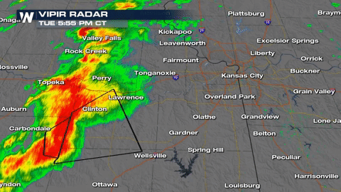
Below is the line of severe thunderstorms that produced the tornado. You can see how numerous Tornado Warnings were issued through time, as the powerful storms moved to the east-northeast, towards Kansas City. The radar loop below starts at 5:55 pm Central Time, and goes through 7:57 pm Central Time.
 Below is video of the large tornado, as it moved through the south side of Lawrence, Kansas.
https://twitter.com/WeatherNation/status/1133531801668935685
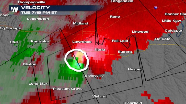
WeatherNation was tracking the storm on Vipir Radar. Below is the velocity product. It shows winds going toward the radar, (in green), and winds going away from the radar, (in red). Where the red and green colors are next to each other, this indicates that winds in close proximity are going in opposite directions. We can then deduce that winds are rotating, and a tornado is possible. Notice how the winds in the circled area are demonstrating this feature. A tornado was likely on the ground at this point, just south of downtown Lawrence. There are reports of damage in the Lawrence area. There was also damage close by in Pleasant Grove, Kansas.
Below is video of the large tornado, as it moved through the south side of Lawrence, Kansas.
https://twitter.com/WeatherNation/status/1133531801668935685
WeatherNation was tracking the storm on Vipir Radar. Below is the velocity product. It shows winds going toward the radar, (in green), and winds going away from the radar, (in red). Where the red and green colors are next to each other, this indicates that winds in close proximity are going in opposite directions. We can then deduce that winds are rotating, and a tornado is possible. Notice how the winds in the circled area are demonstrating this feature. A tornado was likely on the ground at this point, just south of downtown Lawrence. There are reports of damage in the Lawrence area. There was also damage close by in Pleasant Grove, Kansas.
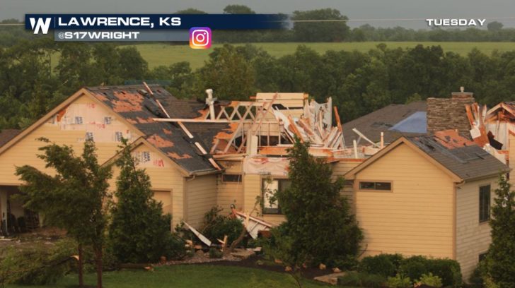
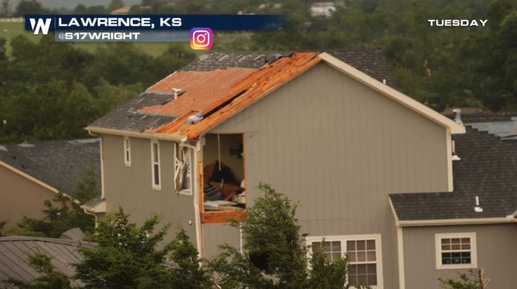
 Below are pictures from Lawrence, Kansas, shortly after the storm blew through:
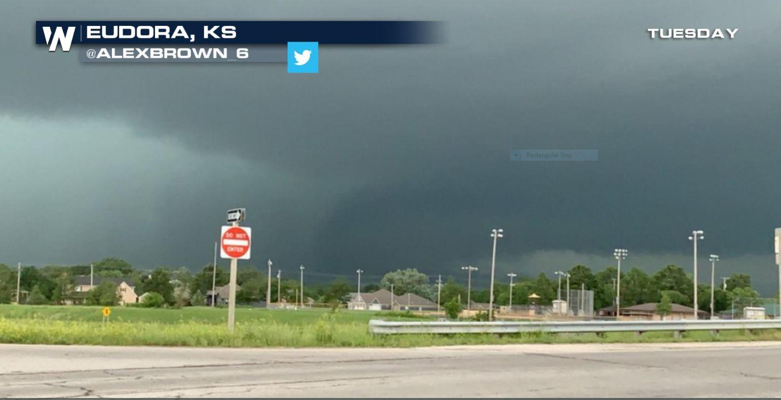
 A few minutes later, the tornado was spotted about seven miles to the east in Eudora, Kansas. There's an amazing picture of the tornado below.
https://twitter.com/WeatherNation/status/1133536210712838144
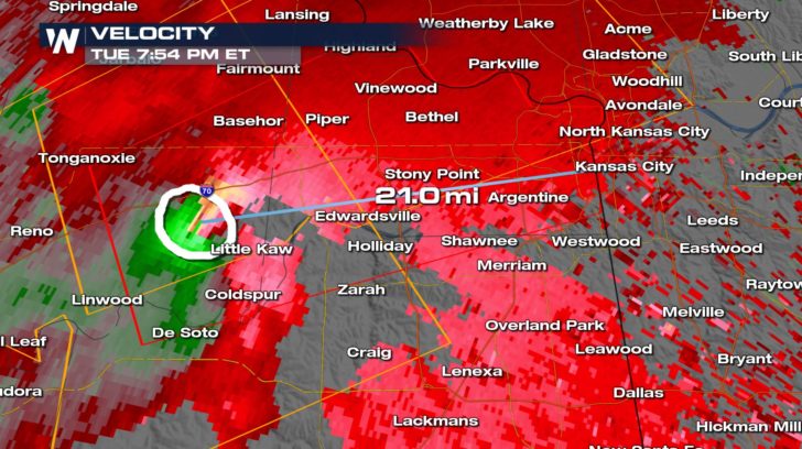
After leaving Eudora, the storm continued on its path to the east-northeast, and was likely a strong tornado just west of Little Kaw, Kansas. At this point, it was just 21 miles west of Kansas City. The tornado warning was then extended eastward to include the Kansas City metro.
A few minutes later, the tornado was spotted about seven miles to the east in Eudora, Kansas. There's an amazing picture of the tornado below.
https://twitter.com/WeatherNation/status/1133536210712838144
After leaving Eudora, the storm continued on its path to the east-northeast, and was likely a strong tornado just west of Little Kaw, Kansas. At this point, it was just 21 miles west of Kansas City. The tornado warning was then extended eastward to include the Kansas City metro.
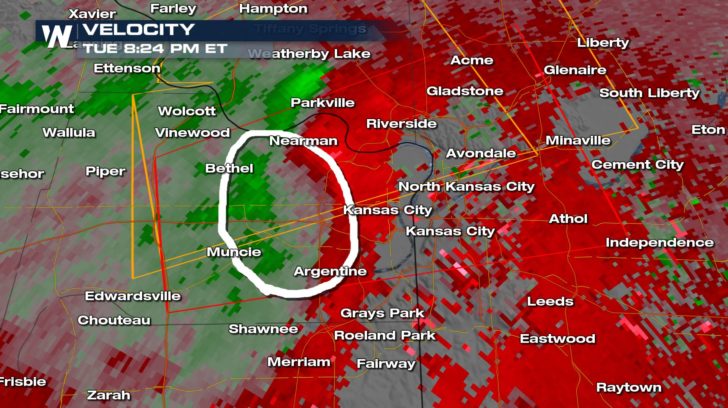
 But fortunately, as the storm approached Kansas City, its rotation began to weaken, and became much more broad. In the velocity scan below, you can see how there is no longer a tight proximity of red and green shaded colors next to each other. Tornadoes often weaken when rain cooled air begins to feed into the lower levels of the storm. This cold air essentially cuts off the rising circulation of the storm, and the tornado often lifts and wraps out. This happened just in the nick of time, before the storm made it to Kansas City. A very close call indeed!
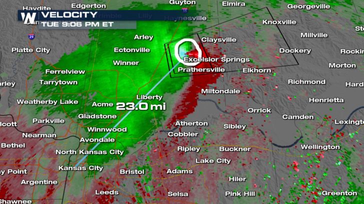
 Of course, tornadoes go through cycles. As the storm travels downstream of the rain cooled air, it can often find new energy in places where the atmosphere remains primed. Warm inflow near the surface can begin again, and a new tornado forms from the same parent thunderstorm. It appears that this happened about 23 miles northeast of Kansas City near the town of Excelsior Springs!
 As severe weather season continues, WeatherNation will continue to track each and every storm, 24 hours a day, seven days a week. You can watch complete coverage on the Dish Network, Roku, Fire TV, Apple TV, Pluto TV, and on any mobile device with the free WeatherNation App.
For WeatherNation: Meteorologist Matt Monroe
As severe weather season continues, WeatherNation will continue to track each and every storm, 24 hours a day, seven days a week. You can watch complete coverage on the Dish Network, Roku, Fire TV, Apple TV, Pluto TV, and on any mobile device with the free WeatherNation App.
For WeatherNation: Meteorologist Matt Monroe
Below is video of the large tornado, as it moved through the south side of Lawrence, Kansas.
https://twitter.com/WeatherNation/status/1133531801668935685
WeatherNation was tracking the storm on Vipir Radar. Below is the velocity product. It shows winds going toward the radar, (in green), and winds going away from the radar, (in red). Where the red and green colors are next to each other, this indicates that winds in close proximity are going in opposite directions. We can then deduce that winds are rotating, and a tornado is possible. Notice how the winds in the circled area are demonstrating this feature. A tornado was likely on the ground at this point, just south of downtown Lawrence. There are reports of damage in the Lawrence area. There was also damage close by in Pleasant Grove, Kansas.
Below are pictures from Lawrence, Kansas, shortly after the storm blew through:
A few minutes later, the tornado was spotted about seven miles to the east in Eudora, Kansas. There's an amazing picture of the tornado below.
https://twitter.com/WeatherNation/status/1133536210712838144
After leaving Eudora, the storm continued on its path to the east-northeast, and was likely a strong tornado just west of Little Kaw, Kansas. At this point, it was just 21 miles west of Kansas City. The tornado warning was then extended eastward to include the Kansas City metro.
But fortunately, as the storm approached Kansas City, its rotation began to weaken, and became much more broad. In the velocity scan below, you can see how there is no longer a tight proximity of red and green shaded colors next to each other. Tornadoes often weaken when rain cooled air begins to feed into the lower levels of the storm. This cold air essentially cuts off the rising circulation of the storm, and the tornado often lifts and wraps out. This happened just in the nick of time, before the storm made it to Kansas City. A very close call indeed!
Of course, tornadoes go through cycles. As the storm travels downstream of the rain cooled air, it can often find new energy in places where the atmosphere remains primed. Warm inflow near the surface can begin again, and a new tornado forms from the same parent thunderstorm. It appears that this happened about 23 miles northeast of Kansas City near the town of Excelsior Springs!
As severe weather season continues, WeatherNation will continue to track each and every storm, 24 hours a day, seven days a week. You can watch complete coverage on the Dish Network, Roku, Fire TV, Apple TV, Pluto TV, and on any mobile device with the free WeatherNation App.
For WeatherNation: Meteorologist Matt Monroe
All Weather News
More


More Storms for the East Through Monday
A low-pressure system that moved through the
3 Aug 2026 1:50 AM

After Reaching Category 5, Genevieve Weakens in the Pacific
PacificGenevieve formed last Friday south of
3 Aug 2026 12:30 AM

Flooding, Severe Storms Target the Midwest Again
After an active week of storms across the nor
1 Aug 2026 1:40 AM

Flooding Risk Increases as Heavy Rain Targets the Tri-State Area
Tuesday, heavy rainfall moved across the Nort
30 Jul 2026 12:25 AM

Severe Weather: Energy From the Midwest Now in the Southeast
UPPER MIDWEST - Through Monday, dangerous tor
29 Jul 2026 10:30 PM