Confirmed Tornado in South Florida Friday Afternoon
Special Stories
27 Apr 2018 3:16 PM
The National Weather Service in Miami says an EF-0 tornado touched down on the Broward and Palm Beach county line Friday afternoon.
https://twitter.com/NWSMiami/status/990036610757681153
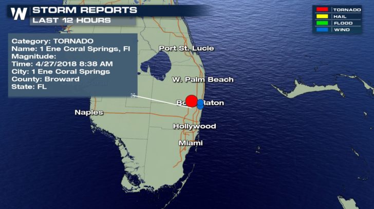 National Weather Service storm reports from Friday, April 27 where blue shows wind gusts or damage and red shows a tornado or funnel cloud report.
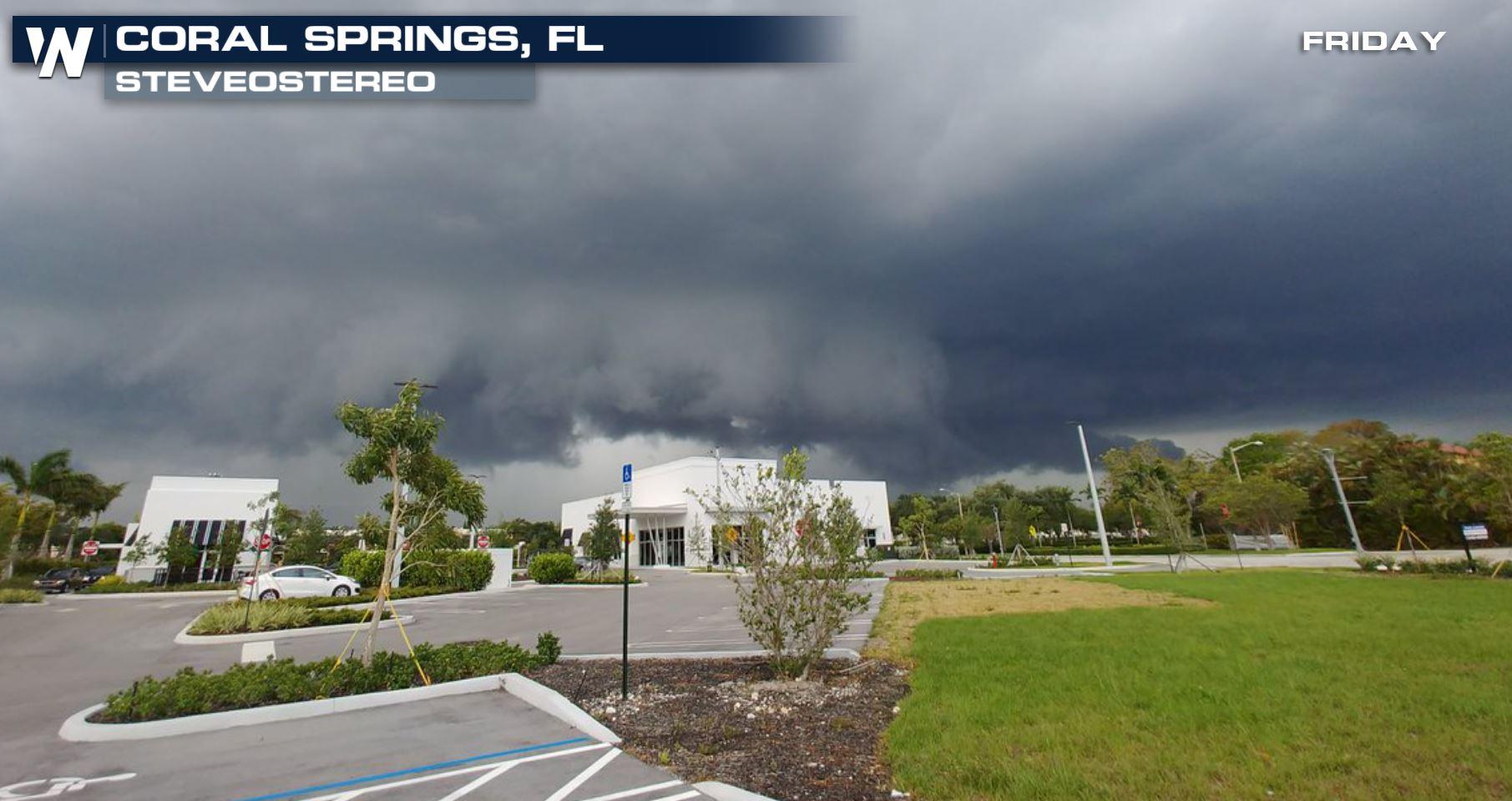
A team of meteorologists from the National Weather Service (Miami) surveyed the area Friday afternoon to come to a conclusion. The team can confirm an EF-0 tornado touched down in Coral Springs. Damage was mostly to trees and vegetation. The top of trees had tree branches snapped and broken off.
People across South Florida were able to take pictures and videos of the funnel cloud and wall cloud that this storm produced.
National Weather Service storm reports from Friday, April 27 where blue shows wind gusts or damage and red shows a tornado or funnel cloud report.
A team of meteorologists from the National Weather Service (Miami) surveyed the area Friday afternoon to come to a conclusion. The team can confirm an EF-0 tornado touched down in Coral Springs. Damage was mostly to trees and vegetation. The top of trees had tree branches snapped and broken off.
People across South Florida were able to take pictures and videos of the funnel cloud and wall cloud that this storm produced.
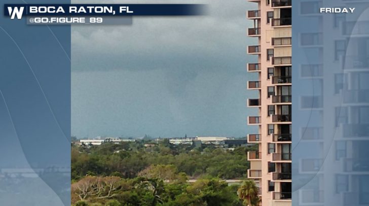 Courtesy @Go.Figure_89 on Instagram
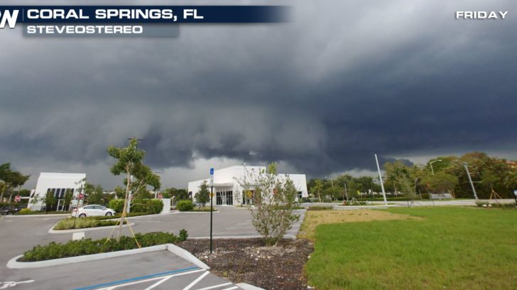 Courtesy @SteveoStereo on Twitter
We haven't heard of any reports of injuries from this storm. The storm itself developed around 2 p.m. eastern as it was enhanced by a building sea breeze.
Courtesy @SteveoStereo on Twitter
We haven't heard of any reports of injuries from this storm. The storm itself developed around 2 p.m. eastern as it was enhanced by a building sea breeze.
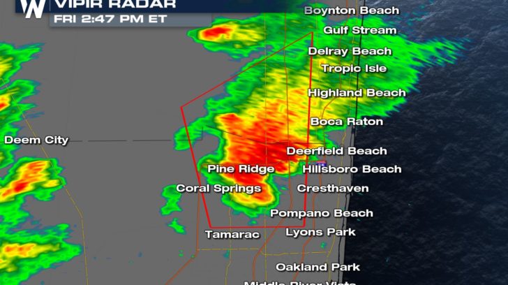 *Old radar image* between West Palm Beach and Ft. Lauderdale, FL Friday afternoon the 27th of April. The red box shows the tornado warning.
It is quite common in the warmer months for storms to build quickly along the sea breeze, when the land temperatures surpass the nearby ocean temperatures. The "sea breeze" begins to build inland because the pressure over the land becomes lower than the nearby water and the air moves toward that lower pressure.
The National Weather Service in Miami is asking folks in this area to send them information about the storm whether it be pictures, videos, or damage reports via Twitter and this link.
For WeatherNation, Meteorologist Steve Glazier
*Old radar image* between West Palm Beach and Ft. Lauderdale, FL Friday afternoon the 27th of April. The red box shows the tornado warning.
It is quite common in the warmer months for storms to build quickly along the sea breeze, when the land temperatures surpass the nearby ocean temperatures. The "sea breeze" begins to build inland because the pressure over the land becomes lower than the nearby water and the air moves toward that lower pressure.
The National Weather Service in Miami is asking folks in this area to send them information about the storm whether it be pictures, videos, or damage reports via Twitter and this link.
For WeatherNation, Meteorologist Steve Glazier
National Weather Service storm reports from Friday, April 27 where blue shows wind gusts or damage and red shows a tornado or funnel cloud report.
A team of meteorologists from the National Weather Service (Miami) surveyed the area Friday afternoon to come to a conclusion. The team can confirm an EF-0 tornado touched down in Coral Springs. Damage was mostly to trees and vegetation. The top of trees had tree branches snapped and broken off.
People across South Florida were able to take pictures and videos of the funnel cloud and wall cloud that this storm produced.
Courtesy @Go.Figure_89 on Instagram
Courtesy @SteveoStereo on Twitter
We haven't heard of any reports of injuries from this storm. The storm itself developed around 2 p.m. eastern as it was enhanced by a building sea breeze.
*Old radar image* between West Palm Beach and Ft. Lauderdale, FL Friday afternoon the 27th of April. The red box shows the tornado warning.
It is quite common in the warmer months for storms to build quickly along the sea breeze, when the land temperatures surpass the nearby ocean temperatures. The "sea breeze" begins to build inland because the pressure over the land becomes lower than the nearby water and the air moves toward that lower pressure.
The National Weather Service in Miami is asking folks in this area to send them information about the storm whether it be pictures, videos, or damage reports via Twitter and this link.
For WeatherNation, Meteorologist Steve GlazierAll Weather News
More
Fronts Continue To Spark Severe Weather Across the Plains
A cold front that brought record lows to the
18 Jul 2025 10:40 PM

Extreme Heat Impacts for the East Coast & South
Extreme heat continues to impact several area
18 Jul 2025 10:05 PM

Flooding Threat Remains Elevated in the East
A cold front pushing through the Eastern Seab
18 Jul 2025 9:10 PM

EF-2 Firenado from the Deer Creek Fire in Utah
A fire tornado was spotted near La Sal, Utah
18 Jul 2025 7:30 AM

Tropical System Brings Flood Risk to the Central Gulf
Time has run out for notable tropical develop
18 Jul 2025 3:05 AM

Heavy Rain, Flooding Threat Returns to Florida
Keep the rain boots handy in Florida - heavy
13 Jul 2025 12:50 PM

Severe Storm Risk Pushes into the Great Lakes, Ohio Valley
Friday was another busy day with severe weath
12 Jul 2025 8:00 PM