The Dance of a Melting Snowflake
Special Stories
2 Apr 2018 7:50 AM
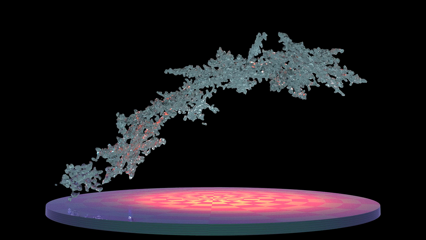
[This model reproduces key features of melting snowflakes that have been observed in nature: first, meltwater gathers in any concave regions of the snowflake's surface. These liquid-water regions merge as they grow and eventually form a shell of liquid around an ice core, finally developing into a water drop. Credit: NASA]
From NASA
NASA has produced the first three-dimensional numerical model of melting snowflakes in the atmosphere. Developed by scientist Jussi Leinonen of NASA's Jet Propulsion Laboratory in Pasadena, California, the model provides a better understanding of how snow melts can help scientists recognize the signature in radar signals of heavier, wetter snow -- the kind that breaks power lines and tree limbs -- and could be a step toward improving predictions of this hazard.
https://www.youtube.com/watch?v=VxhQ3weqmiY
[This visualization is based on the first three-dimensional numerical model of melting snowflakes in the atmosphere, developed by scientist Jussi Leinonen of NASA's Jet Propulsion Laboratory in Pasadena, California. A better understanding of how snow melts can help scientists recognize the signature in radar signals of heavier, wetter snow -- the kind that breaks power lines and tree limbs -- and could be a step toward improving predictions of this hazard. Credits: NASA's Goddard Space Flight Center/ Lauren Ward]
Snowflake research is one of many ways that NASA studies the frozen regions of Earth, collectively known as the cryosphere.
Leinonen's model reproduces key features of melting snowflakes that have been observed in nature. First, meltwater gathers in any concave regions of the snowflake's surface. These liquid-water regions then merge to form a shell of liquid around an ice core, and finally develop into a water drop. The modeled snowflake shown in the video is less than half an inch (one centimeter) long and composed of many individual ice crystals whose arms became entangled when they collided in midair.
Leinonen said he got interested in modeling melting snow because of the way it affects observations with remote sensing instruments. A radar "profile" of the atmosphere from top to bottom shows a very bright, prominent layer at the altitude where falling snow and hail melt -- much brighter than atmospheric layers above and below it. "The reasons for this layer are still not particularly clear, and there has been a bit of debate in the community," Leinonen said.Simpler models can reproduce the bright melt layer, but a more detailed model like this one can help scientists to understand it better, particularly how the layer is related to both the type of melting snow and the radar wavelengths used to observe it.
 A paper on the numerical model, titled "Snowflake melting simulation using smoothed particle hydrodynamics," recently appeared in the Journal of Geophysical Research - Atmospheres.Some of the most remote places on Earth are showing signs of change, with potentially global impacts.
https://www.youtube.com/watch?v=O4yeiZ0s_7g
In 2018, NASA is scheduled to launch two new satellite missions and conduct an array of field research that will enhance our view of Earth’s ice sheets, glaciers, sea ice, snow cover and permafrost. Collectively, these frozen regions are known as the cryosphere. Over the course of the year NASA will share an inside look at what the agency is doing to better understand this critical component of our home planet.
Edited for WeatherNation by Meteorologist Mace Michaels
A paper on the numerical model, titled "Snowflake melting simulation using smoothed particle hydrodynamics," recently appeared in the Journal of Geophysical Research - Atmospheres.Some of the most remote places on Earth are showing signs of change, with potentially global impacts.
https://www.youtube.com/watch?v=O4yeiZ0s_7g
In 2018, NASA is scheduled to launch two new satellite missions and conduct an array of field research that will enhance our view of Earth’s ice sheets, glaciers, sea ice, snow cover and permafrost. Collectively, these frozen regions are known as the cryosphere. Over the course of the year NASA will share an inside look at what the agency is doing to better understand this critical component of our home planet.
Edited for WeatherNation by Meteorologist Mace Michaels
All Weather News
More
Severe Storms Target the Midwest to the Northeast
UPPER MIDWEST - Dangerous tornadoes have alre
27 Jul 2026 10:20 PM


Tropics: Fausto Heads towards Hawaii; Genevieve Cat 4 Hurricane
Atlantic BasinBertha has dissipated after mov
27 Jul 2026 3:00 PM

Southeast Flood Risk Lingers Near Stalled Front
A stalled boundary over the Southeast will ke
25 Jul 2026 10:55 AM

Another Round of Storms Targets the Northeast
Tuesday brought severe weather again across p
23 Jul 2026 1:15 AM

Another Round of Severe Weather for the Upper Midwest and Great Lakes
The upper-level low train continues to keep t
21 Jul 2026 1:45 AM