Dayton Tornado Revised Up To EF-4
Special Stories
30 May 2019 9:26 PM
National Weather Service Meteorologists have changed the estimated strength of this week's Dayton, OH area tornado to an EF-4.
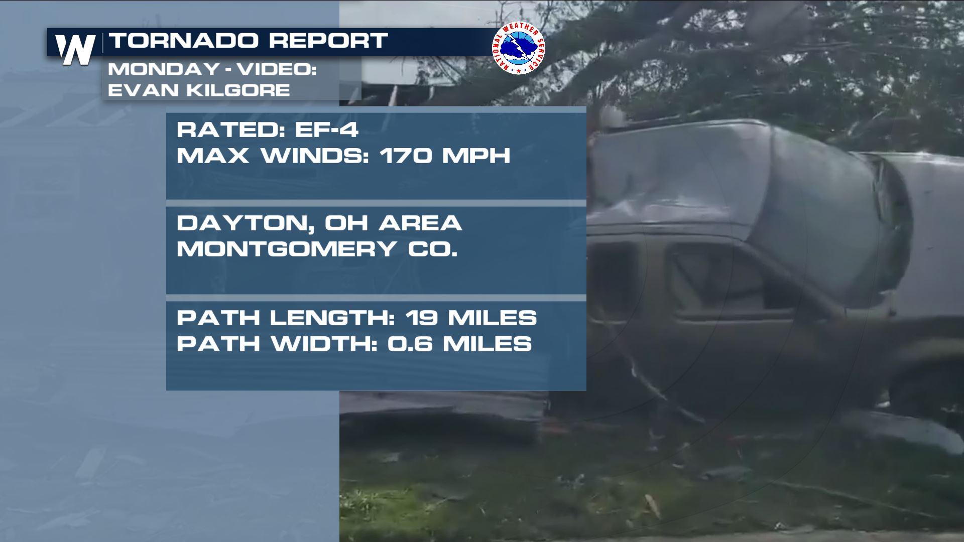
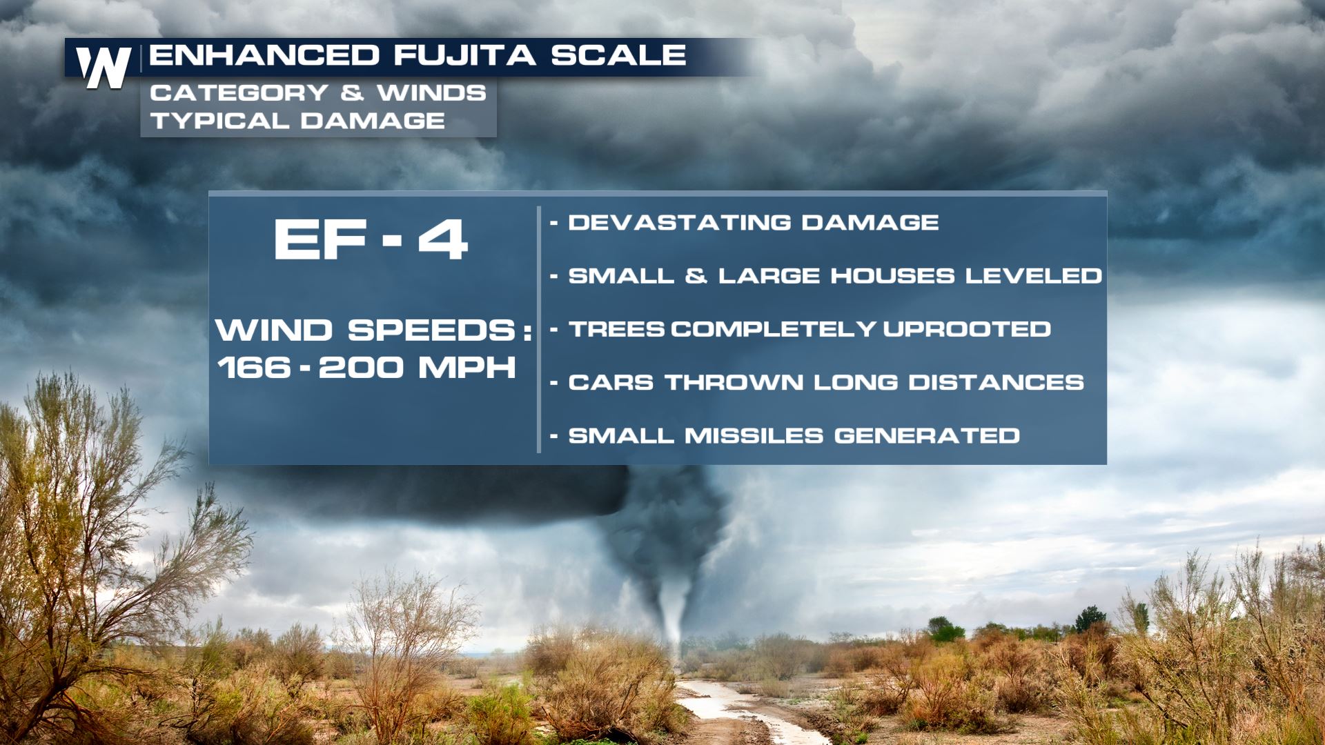
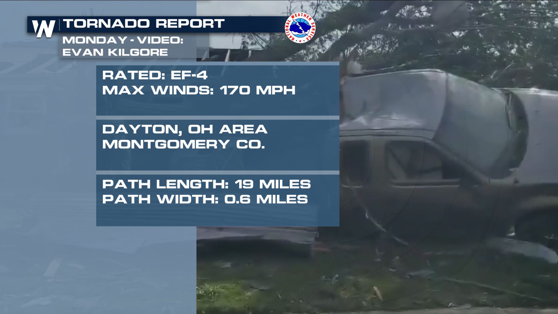 A preliminary report Tuesday estimated the storm's strength as an EF-3, packing wind between 140-150 miles per hour. However Thursday, NWS Wilmington revised that report to now say that the tornado is believed to have been EF-4 strength with wind up to 170 mph. EF stands for Enhanced Fujita, a scale to categorize the strength of tornadoes.
You can read the report via this link here.
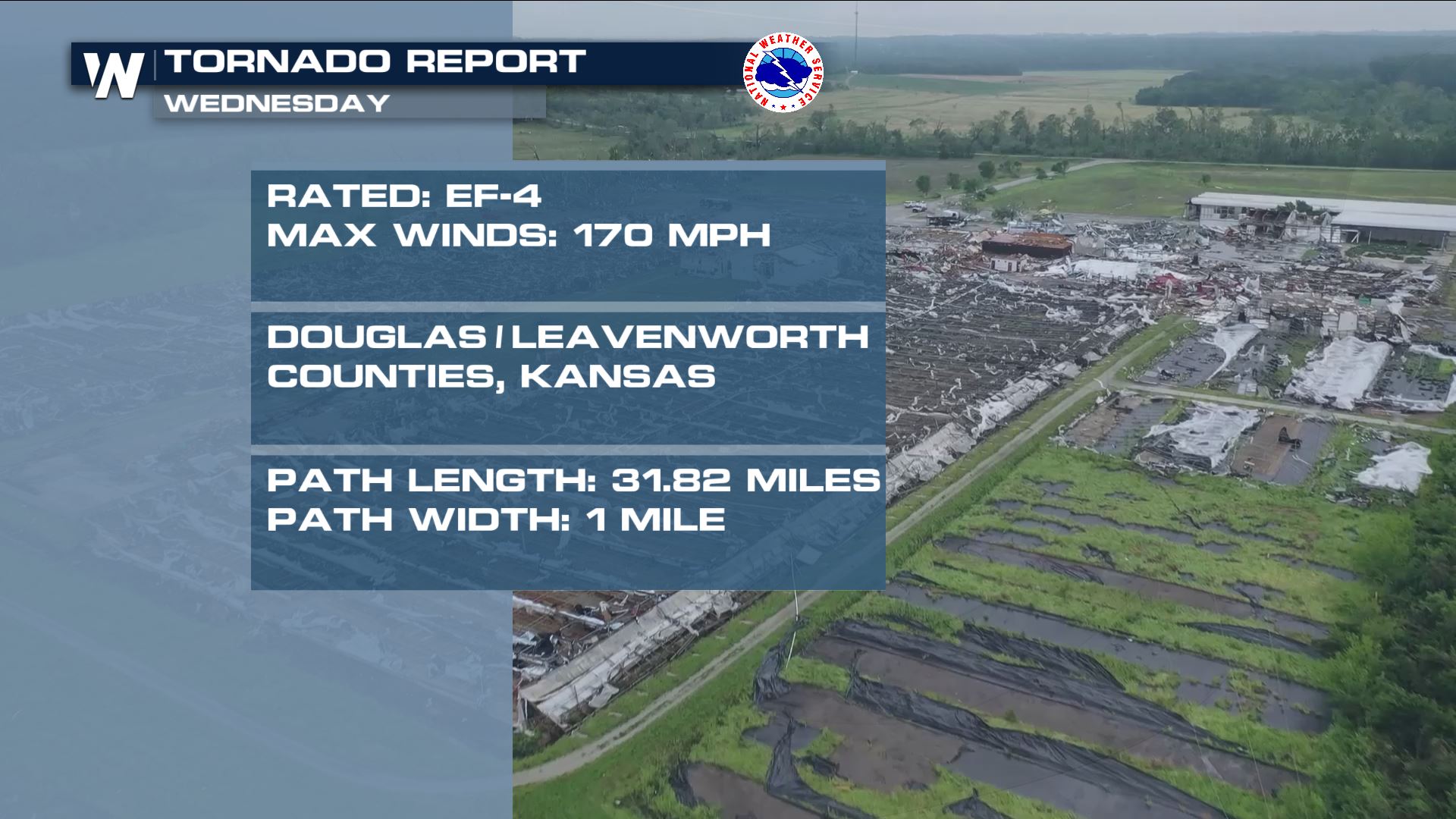
NWS Wilmington said it would provide more detail on the change in the near future. In the meantime, it makes this tornado the first of two violent tornadoes two days in a row this week. The other violent tornado occurred in eastern Kansas, also an EF-4 near Linwood, Lawrence and Kansas City with wind up to 170 mph.
A preliminary report Tuesday estimated the storm's strength as an EF-3, packing wind between 140-150 miles per hour. However Thursday, NWS Wilmington revised that report to now say that the tornado is believed to have been EF-4 strength with wind up to 170 mph. EF stands for Enhanced Fujita, a scale to categorize the strength of tornadoes.
You can read the report via this link here.
NWS Wilmington said it would provide more detail on the change in the near future. In the meantime, it makes this tornado the first of two violent tornadoes two days in a row this week. The other violent tornado occurred in eastern Kansas, also an EF-4 near Linwood, Lawrence and Kansas City with wind up to 170 mph.
 Meteorologists survey the damage from the ground, from the air and also using saved radar data. They look at the damage to structures, how well-built the structures were, the array of tree damage, the placement of debris, and many other factors to determine the strength of a tornado.
 It's not uncommon to revise the strength of a tornado upon further examination. Many times meteorologists will release preliminary estimation for the media and public, then return to take a closer look at the damage.
The Dayton, OH area tornado now makes three violent tornadoes this year in the U.S., joining the Kansas storm this week and March's EF-4 in Lee County, Alabama.
For WeatherNation, Meteorologist Steve Glazier
It's not uncommon to revise the strength of a tornado upon further examination. Many times meteorologists will release preliminary estimation for the media and public, then return to take a closer look at the damage.
The Dayton, OH area tornado now makes three violent tornadoes this year in the U.S., joining the Kansas storm this week and March's EF-4 in Lee County, Alabama.
For WeatherNation, Meteorologist Steve Glazier
A preliminary report Tuesday estimated the storm's strength as an EF-3, packing wind between 140-150 miles per hour. However Thursday, NWS Wilmington revised that report to now say that the tornado is believed to have been EF-4 strength with wind up to 170 mph. EF stands for Enhanced Fujita, a scale to categorize the strength of tornadoes.
You can read the report via this link here.
NWS Wilmington said it would provide more detail on the change in the near future. In the meantime, it makes this tornado the first of two violent tornadoes two days in a row this week. The other violent tornado occurred in eastern Kansas, also an EF-4 near Linwood, Lawrence and Kansas City with wind up to 170 mph.
Meteorologists survey the damage from the ground, from the air and also using saved radar data. They look at the damage to structures, how well-built the structures were, the array of tree damage, the placement of debris, and many other factors to determine the strength of a tornado.
It's not uncommon to revise the strength of a tornado upon further examination. Many times meteorologists will release preliminary estimation for the media and public, then return to take a closer look at the damage.
The Dayton, OH area tornado now makes three violent tornadoes this year in the U.S., joining the Kansas storm this week and March's EF-4 in Lee County, Alabama.
For WeatherNation, Meteorologist Steve GlazierAll Weather News
More
Fronts Continue To Spark Severe Weather Across the Plains
A cold front that brought record lows to the
18 Jul 2025 10:40 PM

Extreme Heat Impacts for the East Coast & South
Extreme heat continues to impact several area
18 Jul 2025 10:05 PM

Flooding Threat Remains Elevated in the East
A cold front pushing through the Eastern Seab
18 Jul 2025 9:10 PM

EF-2 Firenado from the Deer Creek Fire in Utah
A fire tornado was spotted near La Sal, Utah
18 Jul 2025 7:30 AM

Tropical System Brings Flood Risk to the Central Gulf
Time has run out for notable tropical develop
18 Jul 2025 3:05 AM

Heavy Rain, Flooding Threat Returns to Florida
Keep the rain boots handy in Florida - heavy
13 Jul 2025 12:50 PM

Severe Storm Risk Pushes into the Great Lakes, Ohio Valley
Friday was another busy day with severe weath
12 Jul 2025 8:00 PM