December El Nino Update: Neutral, Rinse, Repeat
Special Stories
13 Dec 2019 2:00 AM
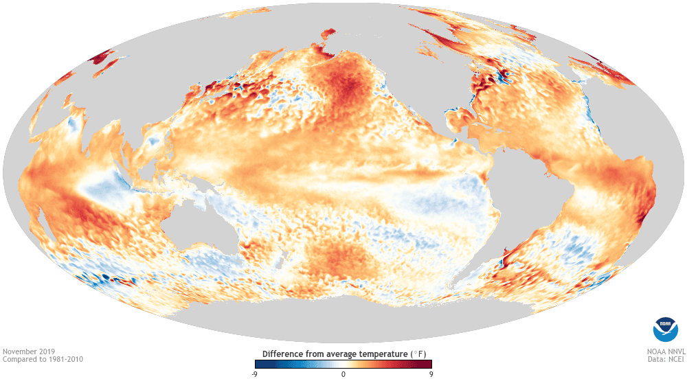
[November sea surface temperature departure from the 1981-2010 average. Image from Data Snapshots from NOAA Climate. The cooler-than-average water in the eastern Indian Ocean is the IOD signature. Also very noticeable here is the marine heatwave in the northern Pacific.]
[NOAA by Tom Di Liberto] Honestly, I could reprint last month’s outlook post and it wouldn’t be that far off from this month. So give me a second to “control-c” last month’s ENSO update…. Ahh there we go… And now to hit “control-v”…
ENSO-Neutral conditions are solidly in place at the moment. Forecasters estimate a 70% chance that neutral conditions last through the winter, and a 65% chance of continuing through spring.
This all probably has you thinking “EN-So what”, or “this all about ENS-nOthing”, or “please ENS-top doing these horrible puns”. But bear with me as we dive into what is going on.
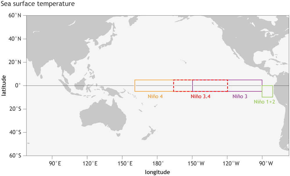 [Location of the Niño regions for measuring sea surface temperature in the eastern and central tropical Pacific Ocean. The sea surface temperature in the Niño3.4 region, spanning from 120˚W to 170˚W longitude, when averaged over a 3-month period, forms NOAA’s official Oceanic Niño Index (the ONI). NOAA Climate image by Fiona Martin.]
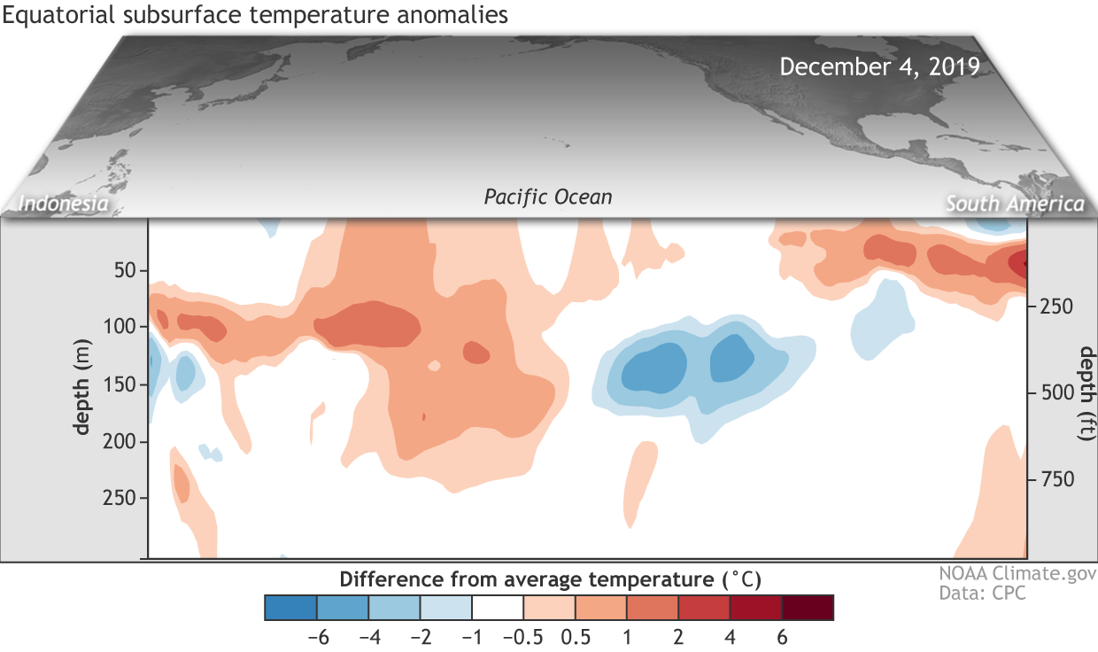 [Departure from average of the surface and subsurface tropical Pacific sea temperature averaged over the 5-day period centered on December 4. The vertical axis is depth below the surface (meters) and the horizontal axis is longitude, from the western to eastern tropical Pacific. This cross-section is right along the equator. Upwelling (cold anomaly) and downwelling (warm anomaly) kelvin waves were moving across the equatorial Pacific Ocean. NOAA Climate figure from CPC data.]
The atmosphere has also been pretty meh, or said in a more professional way “neutral.” The trade winds across the Pacific, which tend to relax or even reverse during El Niño and speed up during La Niña, were near-average during November.
Meanwhile, thunderstorm activity reflected neither El Niño nor La Niña as it continued to be below-average over Indonesia and the Date Line and enhanced over the western Pacific. In fact, this pattern over the last thirty days is pretty similar to the pattern during the previous 30 days. Another strong point in favor of neutral ENSO conditions across the Pacific.
[Departure from average of the surface and subsurface tropical Pacific sea temperature averaged over the 5-day period centered on December 4. The vertical axis is depth below the surface (meters) and the horizontal axis is longitude, from the western to eastern tropical Pacific. This cross-section is right along the equator. Upwelling (cold anomaly) and downwelling (warm anomaly) kelvin waves were moving across the equatorial Pacific Ocean. NOAA Climate figure from CPC data.]
The atmosphere has also been pretty meh, or said in a more professional way “neutral.” The trade winds across the Pacific, which tend to relax or even reverse during El Niño and speed up during La Niña, were near-average during November.
Meanwhile, thunderstorm activity reflected neither El Niño nor La Niña as it continued to be below-average over Indonesia and the Date Line and enhanced over the western Pacific. In fact, this pattern over the last thirty days is pretty similar to the pattern during the previous 30 days. Another strong point in favor of neutral ENSO conditions across the Pacific.
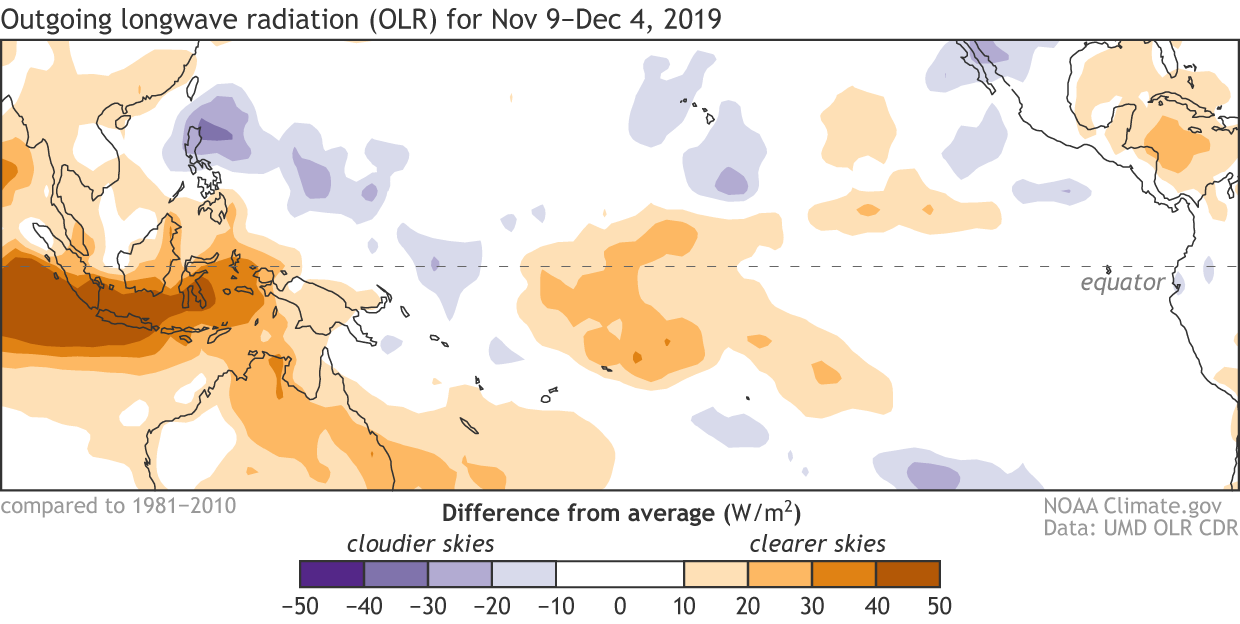 [Places that were more (purple) or less (orange) cloudy than the 1981-2010 average during mid-November to mid-December 2019, based on satellite observations of OLR (outgoing longwave radiation, or heat). Thick clouds block heat from radiating out to space, so less radiation equals more clouds and rainfall, and more radiation equals clearer skies. The lack of clouds and rain resulting from the cooler-than-average side of the IOD can be seen on the left of this map. NOAA Climate map from CPC data.]
Looking to the future, most models continue to favor ENSO-neutral through the summer of 2020, even as many models have positive Niño3.4 SST anomaly values closer to 0.5°C lasting into December. Those elevated ocean temperatures are one reason why we can’t rule out an El Niño, even though the odds of one— 25-30% through spring— remain well below the chances of ENSO-Neutral.
We’ll continue to monitor what’s going on above and below the water across the equatorial Pacific to see if anything changes, but expect ENSO-Neutral to last for a bit.
[Places that were more (purple) or less (orange) cloudy than the 1981-2010 average during mid-November to mid-December 2019, based on satellite observations of OLR (outgoing longwave radiation, or heat). Thick clouds block heat from radiating out to space, so less radiation equals more clouds and rainfall, and more radiation equals clearer skies. The lack of clouds and rain resulting from the cooler-than-average side of the IOD can be seen on the left of this map. NOAA Climate map from CPC data.]
Looking to the future, most models continue to favor ENSO-neutral through the summer of 2020, even as many models have positive Niño3.4 SST anomaly values closer to 0.5°C lasting into December. Those elevated ocean temperatures are one reason why we can’t rule out an El Niño, even though the odds of one— 25-30% through spring— remain well below the chances of ENSO-Neutral.
We’ll continue to monitor what’s going on above and below the water across the equatorial Pacific to see if anything changes, but expect ENSO-Neutral to last for a bit.
[Location of the Niño regions for measuring sea surface temperature in the eastern and central tropical Pacific Ocean. The sea surface temperature in the Niño3.4 region, spanning from 120˚W to 170˚W longitude, when averaged over a 3-month period, forms NOAA’s official Oceanic Niño Index (the ONI). NOAA Climate image by Fiona Martin.]
You can’t ENS-top me now! (That’s it, I promise)
If you just looked at the sea surface temperatures (SST) anomalies—differences from the long-term average—in the Niño3.4 region in the east-central tropical Pacific, you might be thinking that it’s odd that we continue to say how boring things are, ENSO-wise. After hovering around 0.5°C during the end of November, lately the SST anomaly has been around 0.3°C. Not high enough to rise into El Niño territory but certainly above-average. In fact, in the westernmost region we look at, Niño4, SST anomalies are noticeably higher at 0.9°C. However, across the entire tropical Pacific along the equator upper ocean temperature anomalies are nearly zero, as both a downwelling ( warmer water sloshes east) and upwelling (cooler water moves east) Kelvin wave move through different depths and areas of the ocean. All of this is to say that the oceans are looking pretty neutral on average.
[Departure from average of the surface and subsurface tropical Pacific sea temperature averaged over the 5-day period centered on December 4. The vertical axis is depth below the surface (meters) and the horizontal axis is longitude, from the western to eastern tropical Pacific. This cross-section is right along the equator. Upwelling (cold anomaly) and downwelling (warm anomaly) kelvin waves were moving across the equatorial Pacific Ocean. NOAA Climate figure from CPC data.]
The atmosphere has also been pretty meh, or said in a more professional way “neutral.” The trade winds across the Pacific, which tend to relax or even reverse during El Niño and speed up during La Niña, were near-average during November.
Meanwhile, thunderstorm activity reflected neither El Niño nor La Niña as it continued to be below-average over Indonesia and the Date Line and enhanced over the western Pacific. In fact, this pattern over the last thirty days is pretty similar to the pattern during the previous 30 days. Another strong point in favor of neutral ENSO conditions across the Pacific.
[Places that were more (purple) or less (orange) cloudy than the 1981-2010 average during mid-November to mid-December 2019, based on satellite observations of OLR (outgoing longwave radiation, or heat). Thick clouds block heat from radiating out to space, so less radiation equals more clouds and rainfall, and more radiation equals clearer skies. The lack of clouds and rain resulting from the cooler-than-average side of the IOD can be seen on the left of this map. NOAA Climate map from CPC data.]
Looking to the future, most models continue to favor ENSO-neutral through the summer of 2020, even as many models have positive Niño3.4 SST anomaly values closer to 0.5°C lasting into December. Those elevated ocean temperatures are one reason why we can’t rule out an El Niño, even though the odds of one— 25-30% through spring— remain well below the chances of ENSO-Neutral.
We’ll continue to monitor what’s going on above and below the water across the equatorial Pacific to see if anything changes, but expect ENSO-Neutral to last for a bit.
All Weather News
More
Fronts Continue To Spark Severe Weather Across the Plains
A cold front that brought record lows to the
18 Jul 2025 10:40 PM

Extreme Heat Impacts for the East Coast & South
Extreme heat continues to impact several area
18 Jul 2025 10:05 PM

Flooding Threat Remains Elevated in the East
A cold front pushing through the Eastern Seab
18 Jul 2025 9:10 PM

EF-2 Firenado from the Deer Creek Fire in Utah
A fire tornado was spotted near La Sal, Utah
18 Jul 2025 7:30 AM

Tropical System Brings Flood Risk to the Central Gulf
Time has run out for notable tropical develop
18 Jul 2025 3:05 AM

Heavy Rain, Flooding Threat Returns to Florida
Keep the rain boots handy in Florida - heavy
13 Jul 2025 12:50 PM

Severe Storm Risk Pushes into the Great Lakes, Ohio Valley
Friday was another busy day with severe weath
12 Jul 2025 8:00 PM