December-Like Weather to Invade North-Central U.S.
Top Stories
6 Nov 2018 9:24 PM
The air arriving across much of the central United States will be well ahead of schedule, at least in terms of what it will feel like for this time of the year!
 A wave of frigid air will push southeast from Canada beginning Wednesday. By Friday and Saturday it'll reach the East coast. While on its journey, this air mass will bring temperatures down to -10 to -25 degrees compared to average!
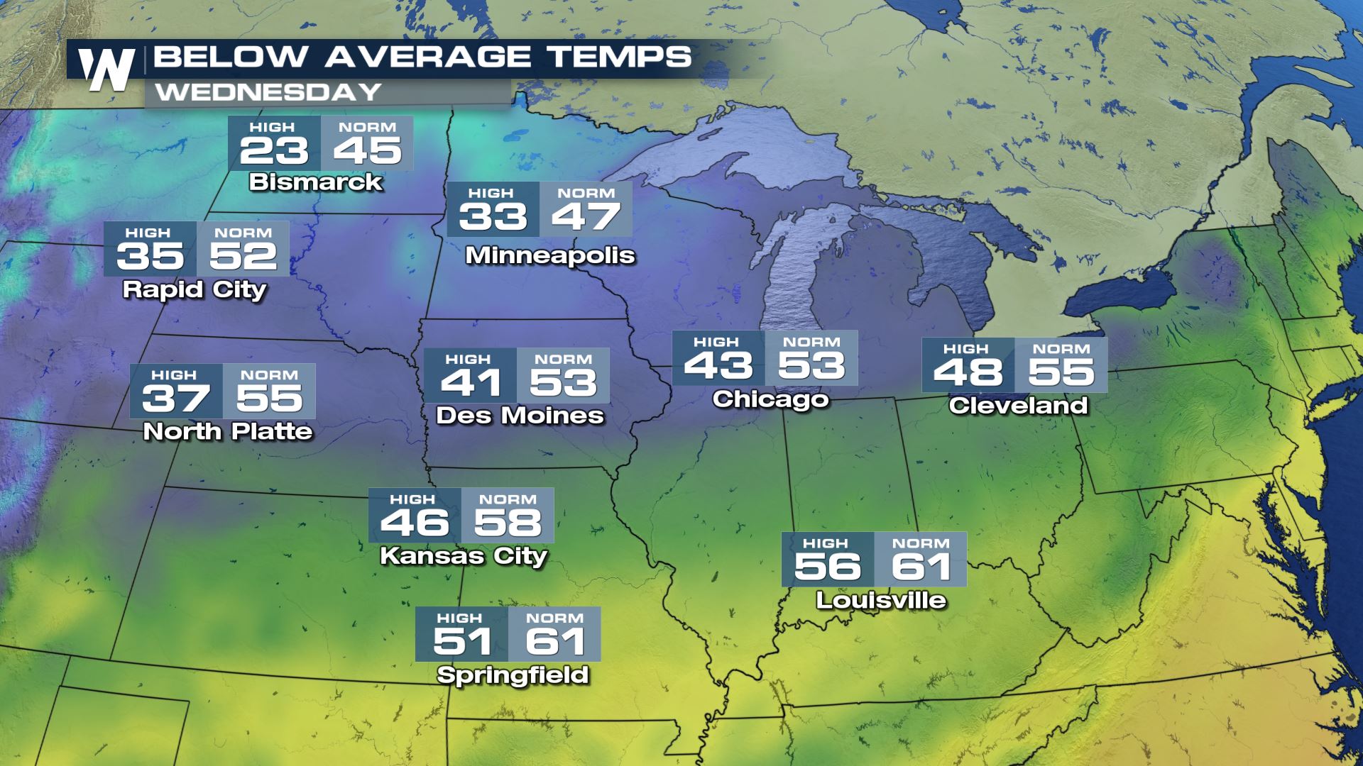
First up will be parts of Montana and North Dakota on Wednesday.
A wave of frigid air will push southeast from Canada beginning Wednesday. By Friday and Saturday it'll reach the East coast. While on its journey, this air mass will bring temperatures down to -10 to -25 degrees compared to average!
First up will be parts of Montana and North Dakota on Wednesday.
 High temperatures (left) versus average high temperatures (right) will be coldest compared to average in North and South Dakota, Nebraska and Montana. Meanwhile, the Great Lakes will feel cool, but not as chilly.
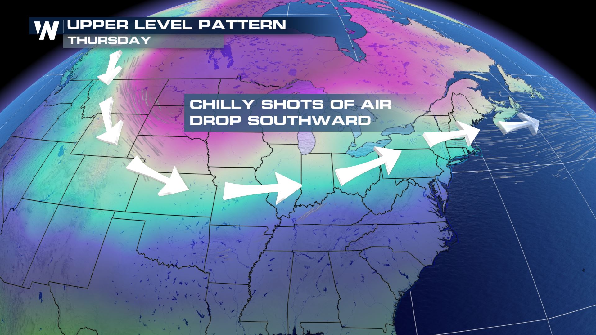
Next up Thursday, this air mass swings into the Great Lakes and knocks on the door of the Northeast.
High temperatures (left) versus average high temperatures (right) will be coldest compared to average in North and South Dakota, Nebraska and Montana. Meanwhile, the Great Lakes will feel cool, but not as chilly.
Next up Thursday, this air mass swings into the Great Lakes and knocks on the door of the Northeast.
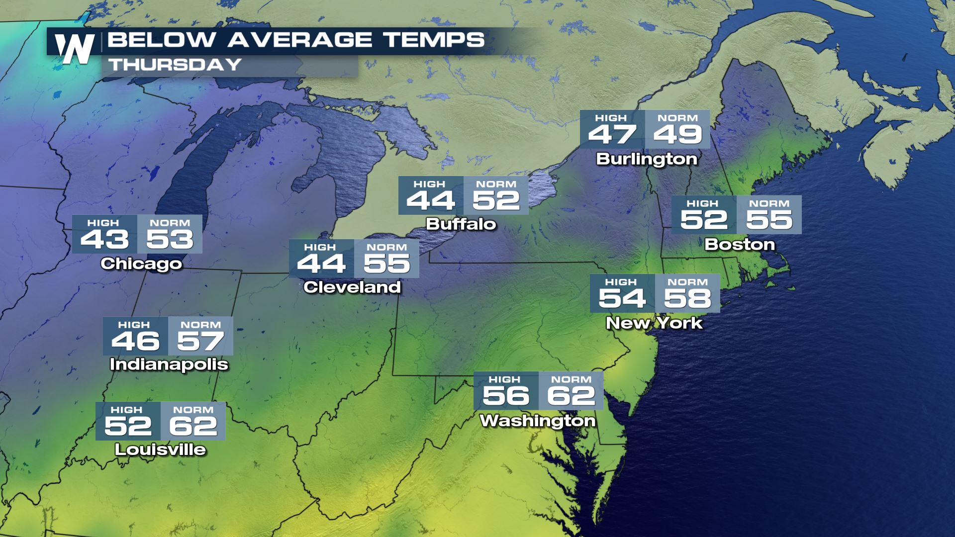 Enjoy Thursday along the immediate East coast! That's because temperatures will only go down into Saturday and Sunday.
Next up on Friday is parts of the Southeast!
Enjoy Thursday along the immediate East coast! That's because temperatures will only go down into Saturday and Sunday.
Next up on Friday is parts of the Southeast!
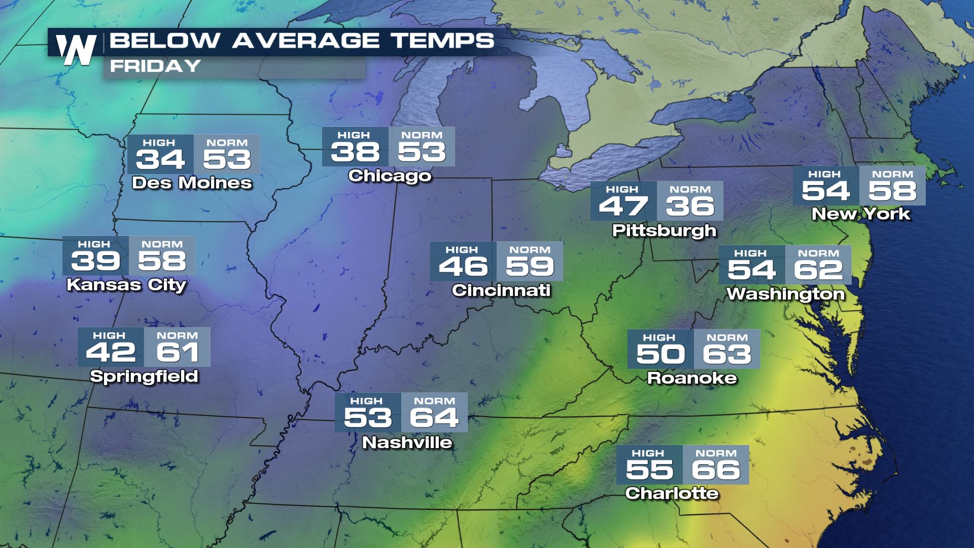 The leading edge of the cold air will be pressing across the Mississippi River Valley. It'll make Kansas City feel 20 degrees colder than average! Des Moines will merely nudge above freezing. Nashville will feel a good -10 degrees to average.
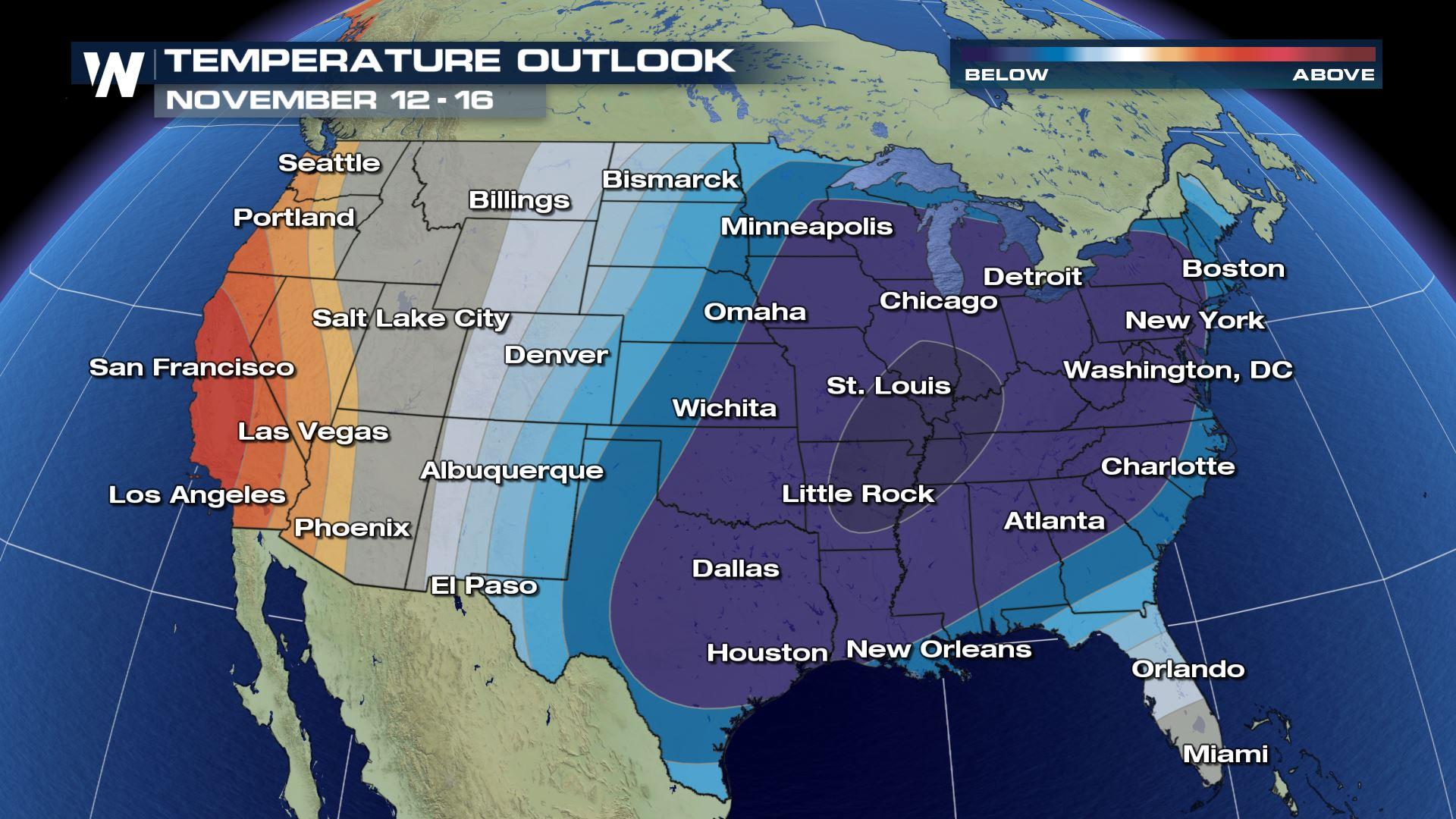
 This all sets the stage for the forecast temperatures for next week. After we get through this weekend, another strong front will pass through the Lower 48 on Tuesday, the 13th. This is expected to bring another cold blast of air to the central/eastern U.S.
It's time to winterize your home and automobile. Make sure you have a cold weather kit and appropriate traction for your vehicle's tires. Stay covered in the wind, as it'll make it feel even colder!
For WeatherNation, Meteorologist Steve Glazier
This all sets the stage for the forecast temperatures for next week. After we get through this weekend, another strong front will pass through the Lower 48 on Tuesday, the 13th. This is expected to bring another cold blast of air to the central/eastern U.S.
It's time to winterize your home and automobile. Make sure you have a cold weather kit and appropriate traction for your vehicle's tires. Stay covered in the wind, as it'll make it feel even colder!
For WeatherNation, Meteorologist Steve Glazier
A wave of frigid air will push southeast from Canada beginning Wednesday. By Friday and Saturday it'll reach the East coast. While on its journey, this air mass will bring temperatures down to -10 to -25 degrees compared to average!
First up will be parts of Montana and North Dakota on Wednesday.
High temperatures (left) versus average high temperatures (right) will be coldest compared to average in North and South Dakota, Nebraska and Montana. Meanwhile, the Great Lakes will feel cool, but not as chilly.
Next up Thursday, this air mass swings into the Great Lakes and knocks on the door of the Northeast.
Enjoy Thursday along the immediate East coast! That's because temperatures will only go down into Saturday and Sunday.
Next up on Friday is parts of the Southeast!
The leading edge of the cold air will be pressing across the Mississippi River Valley. It'll make Kansas City feel 20 degrees colder than average! Des Moines will merely nudge above freezing. Nashville will feel a good -10 degrees to average.
This all sets the stage for the forecast temperatures for next week. After we get through this weekend, another strong front will pass through the Lower 48 on Tuesday, the 13th. This is expected to bring another cold blast of air to the central/eastern U.S.
It's time to winterize your home and automobile. Make sure you have a cold weather kit and appropriate traction for your vehicle's tires. Stay covered in the wind, as it'll make it feel even colder!
For WeatherNation, Meteorologist Steve GlazierAll Weather News
More
More Storms for the East Through Monday
A low-pressure system that moved through the
3 Aug 2026 12:20 PM


After Reaching Category 5, Genevieve Weakens in the Pacific
PacificGenevieve formed last Friday south of
3 Aug 2026 12:30 AM

Flooding, Severe Storms Target the Midwest Again
After an active week of storms across the nor
1 Aug 2026 1:40 AM

Flooding Risk Increases as Heavy Rain Targets the Tri-State Area
Tuesday, heavy rainfall moved across the Nort
30 Jul 2026 12:25 AM

Severe Weather: Energy From the Midwest Now in the Southeast
UPPER MIDWEST - Through Monday, dangerous tor
29 Jul 2026 10:30 PM