Deadly Tornadoes Strike South Wednesday
Special Stories
23 Apr 2020 7:05 AM
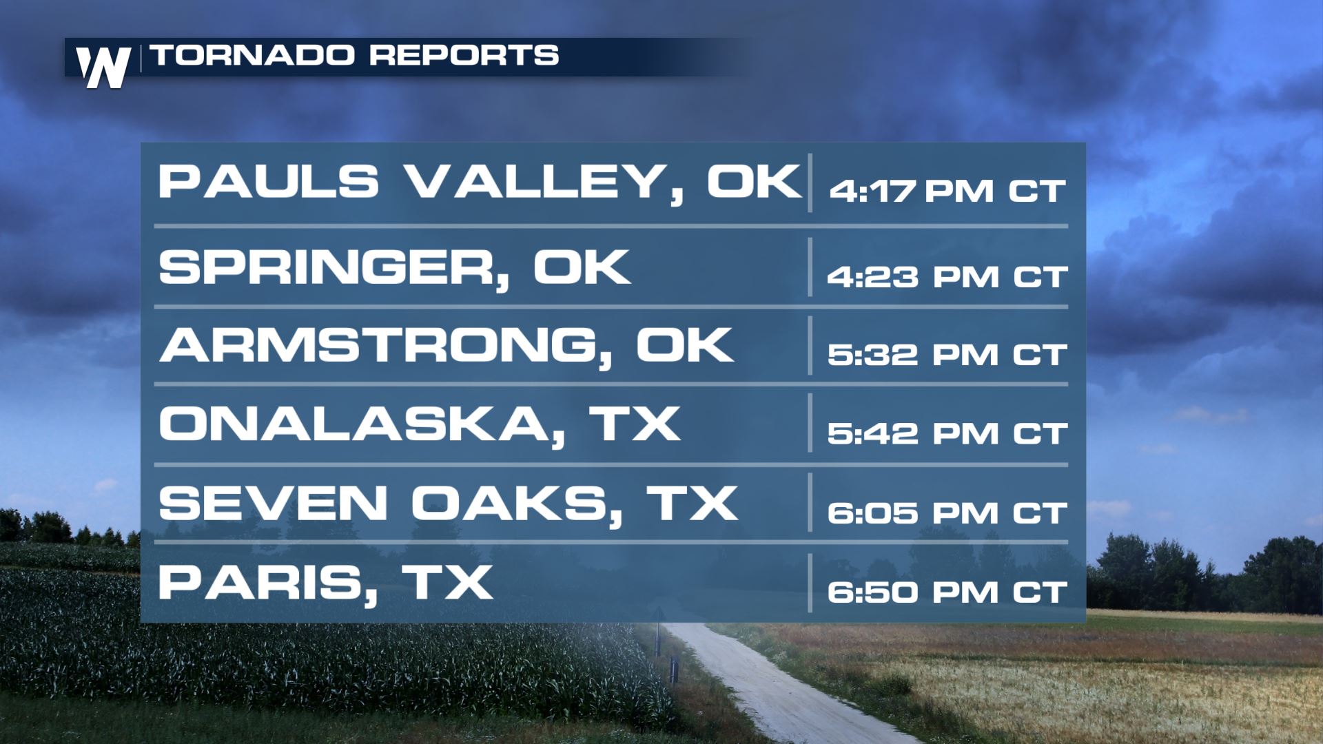
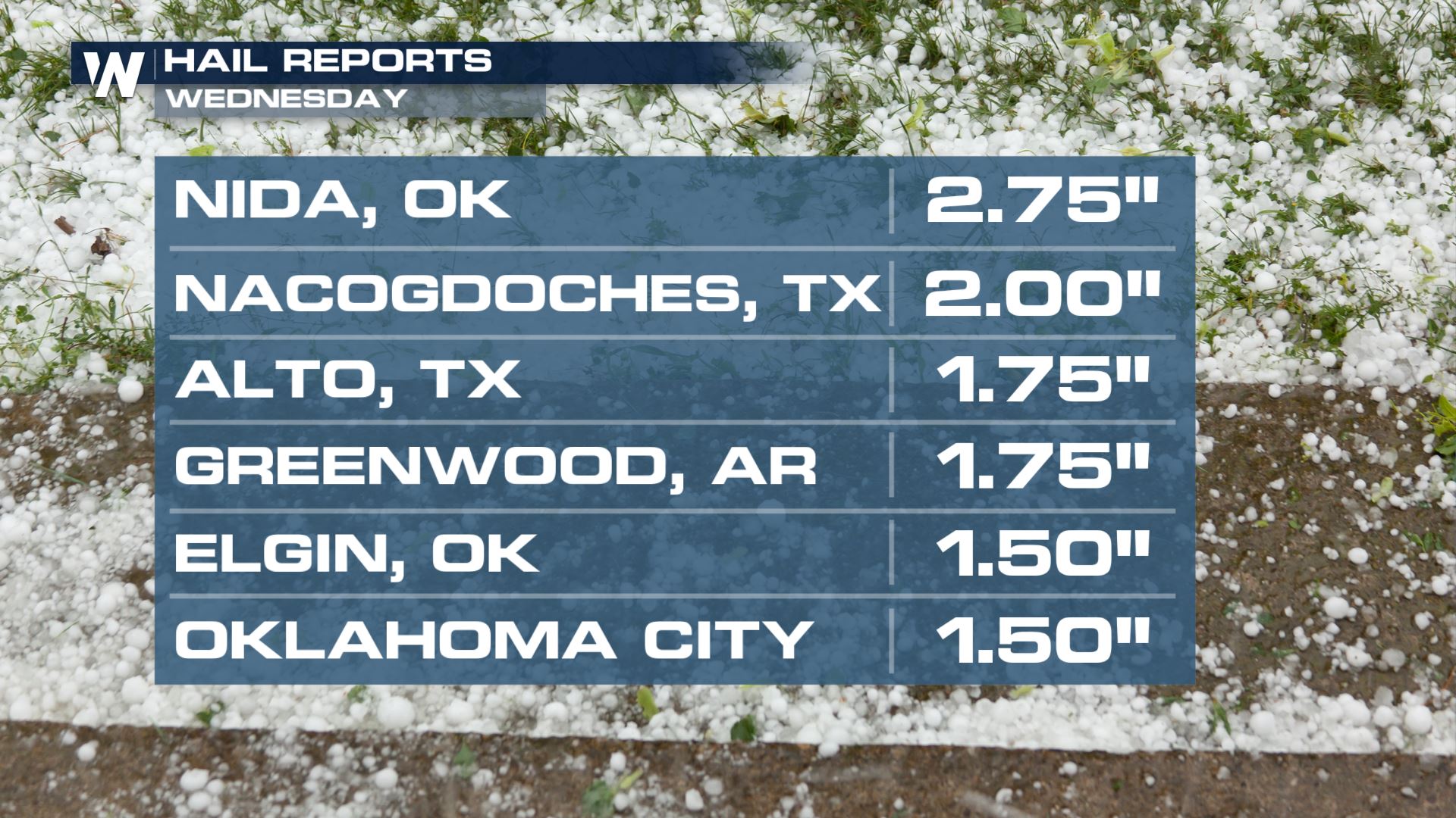
Another powerful severe weather outbreak strikes the south. Multiple large tornadoes were reported on the ground. Including a deadly tornado in Madill, OK where our Field Correspondent Tony Russell was able to get damage video at first light.
https://twitter.com/WeatherNation/status/1253311461582974976
https://www.facebook.com/WeatherNation/videos/571366170167220/
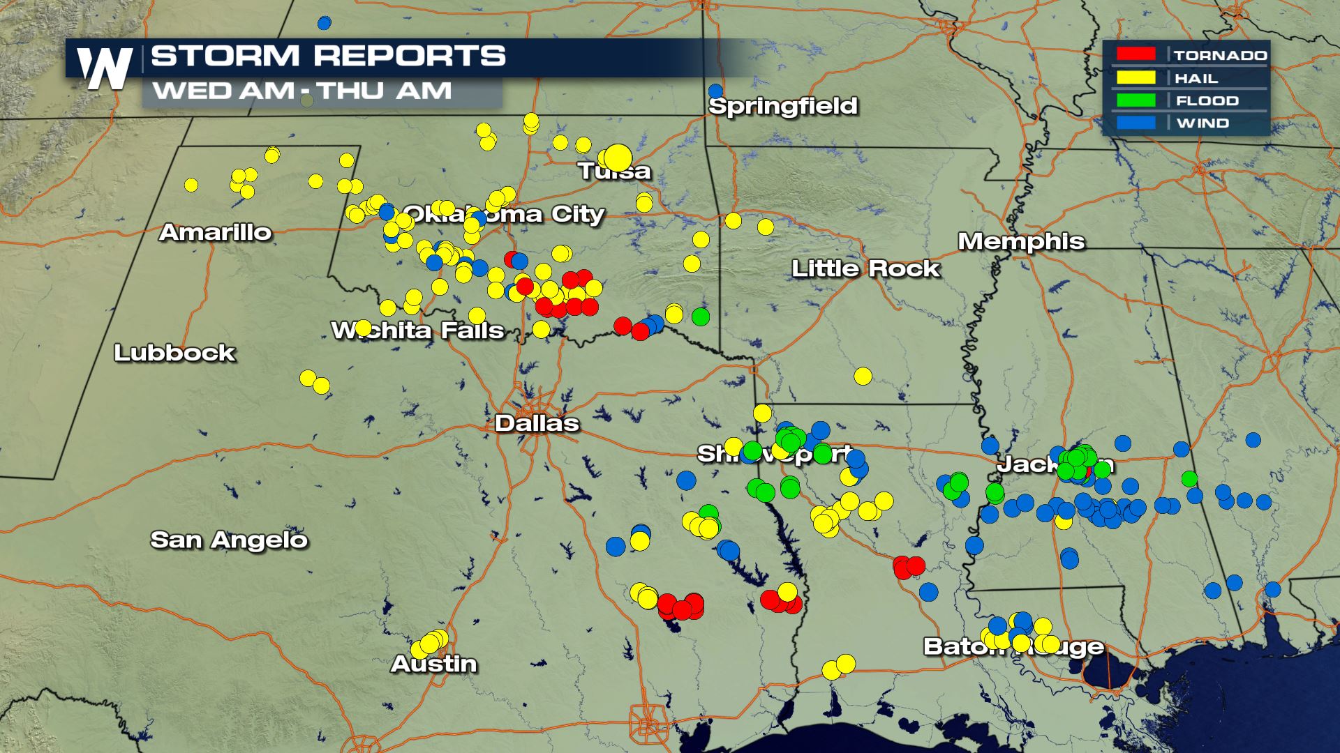 The threat for severe thunderstorms continued overnight into Thursday morning into the Mississippi Delta region. Areas generally along and east of the Red River were under a risk for severe weather. Warm temperatures, coupled with high humidity and a strong jet stream created severe thunderstorms overnight and early Thursday morning. The added moisture was mostly supplied by a rich flow from Gulf of Mexico. Climbing temperatures produced plenty of energy (CAPE) to fuel stronger storms.
For Thursday, a strengthening low pressure center will continue to push eastward toward the Mississippi River delta. Thunderstorms will fire ahead of the main cold front. Initially forming as supercells, the thunderstorms will likely develop into a line, bringing straight-line wind damage. However, the threat for tornadoes will remain.There will also be very heavy rainfall. This could lead to flooding in some areas.
WeatherNation will keep you updated on the severe weather threat on-air and online. Be sure to check back for updates!
The threat for severe thunderstorms continued overnight into Thursday morning into the Mississippi Delta region. Areas generally along and east of the Red River were under a risk for severe weather. Warm temperatures, coupled with high humidity and a strong jet stream created severe thunderstorms overnight and early Thursday morning. The added moisture was mostly supplied by a rich flow from Gulf of Mexico. Climbing temperatures produced plenty of energy (CAPE) to fuel stronger storms.
For Thursday, a strengthening low pressure center will continue to push eastward toward the Mississippi River delta. Thunderstorms will fire ahead of the main cold front. Initially forming as supercells, the thunderstorms will likely develop into a line, bringing straight-line wind damage. However, the threat for tornadoes will remain.There will also be very heavy rainfall. This could lead to flooding in some areas.
WeatherNation will keep you updated on the severe weather threat on-air and online. Be sure to check back for updates!All Weather News
More
Fronts Continue To Spark Severe Weather Across the Plains
A cold front that brought record lows to the
18 Jul 2025 10:40 PM

Extreme Heat Impacts for the East Coast & South
Extreme heat continues to impact several area
18 Jul 2025 10:05 PM

Flooding Threat Remains Elevated in the East
A cold front pushing through the Eastern Seab
18 Jul 2025 9:10 PM

EF-2 Firenado from the Deer Creek Fire in Utah
A fire tornado was spotted near La Sal, Utah
18 Jul 2025 7:30 AM

Tropical System Brings Flood Risk to the Central Gulf
Time has run out for notable tropical develop
18 Jul 2025 3:05 AM

Heavy Rain, Flooding Threat Returns to Florida
Keep the rain boots handy in Florida - heavy
13 Jul 2025 12:50 PM

Severe Storm Risk Pushes into the Great Lakes, Ohio Valley
Friday was another busy day with severe weath
12 Jul 2025 8:00 PM