Tropical Storm Dorian Strengthens in the Atlantic

Top Stories
26 Aug 2019 3:12 AM
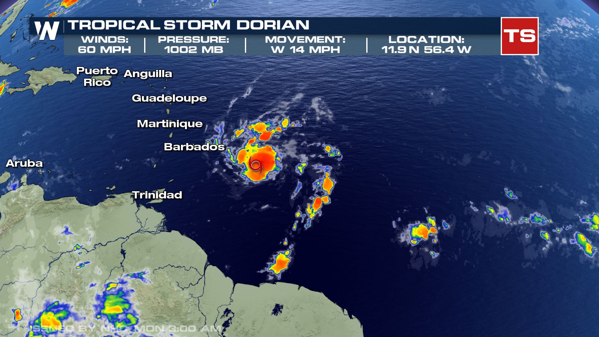
Tropical Storm Dorian remains east of St. Lucia. The storm gradually intensified early this morning with winds increasing to 60 mph. Dorian is moving west at 14 mph and is expected to bring tropical storm conditions to portions of the Lesser Antilles and Windward Islands Monday.
 Tropical Alerts are in place for the Windward Islands. Additional watches or warnings may be issued for portions of the Leeward Islands Monday morning.
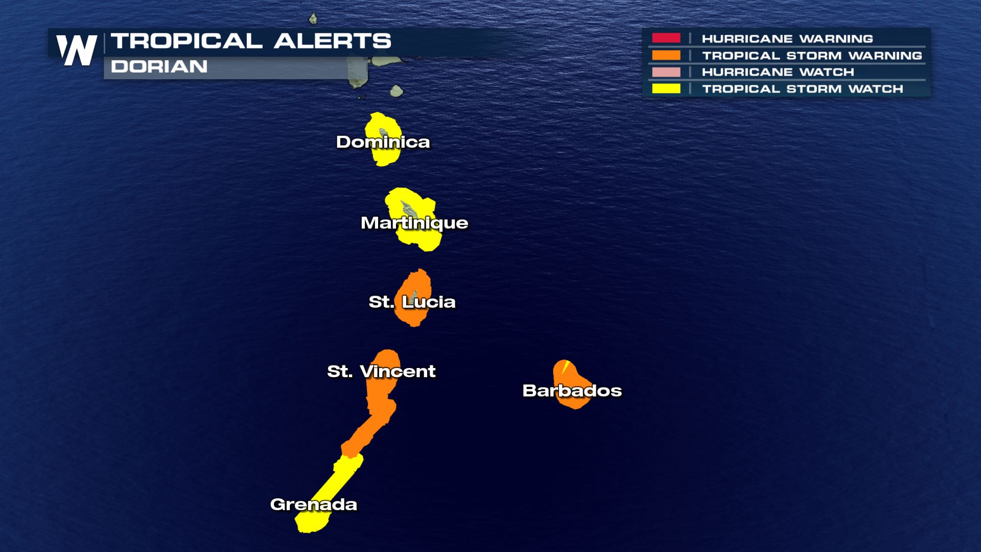 Tropical Storm Warnings are in place for Barbados, St. Lucia, St. Vincent and the Grenadines. Tropical storm force winds in excess of 39 mph will arrive in Barbados Monday and then continue westward.
In addition to strong winds, Dorian will also produce heavy rainfall across portions of the Lesser Antilles and Windward Islands. 2 to 4 inches of rainfall is expected, with isolated amounts as high as 6 inches.
Tropical Storm Warnings are in place for Barbados, St. Lucia, St. Vincent and the Grenadines. Tropical storm force winds in excess of 39 mph will arrive in Barbados Monday and then continue westward.
In addition to strong winds, Dorian will also produce heavy rainfall across portions of the Lesser Antilles and Windward Islands. 2 to 4 inches of rainfall is expected, with isolated amounts as high as 6 inches.
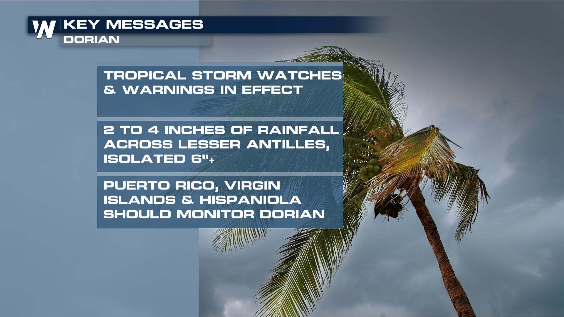 Some gradual intensification is still expected over the next few days, despite the fact that this system will encounter some dry air and wind shear. Dorian may become a Category 1 hurricane by the middle of the week. Puerto Rico, the Virgin Islands, and Hispaniola should monitor the progression of Dorian over the next couple of days. It is still too early to pinpoint the time or magnitude of possible direct impacts.
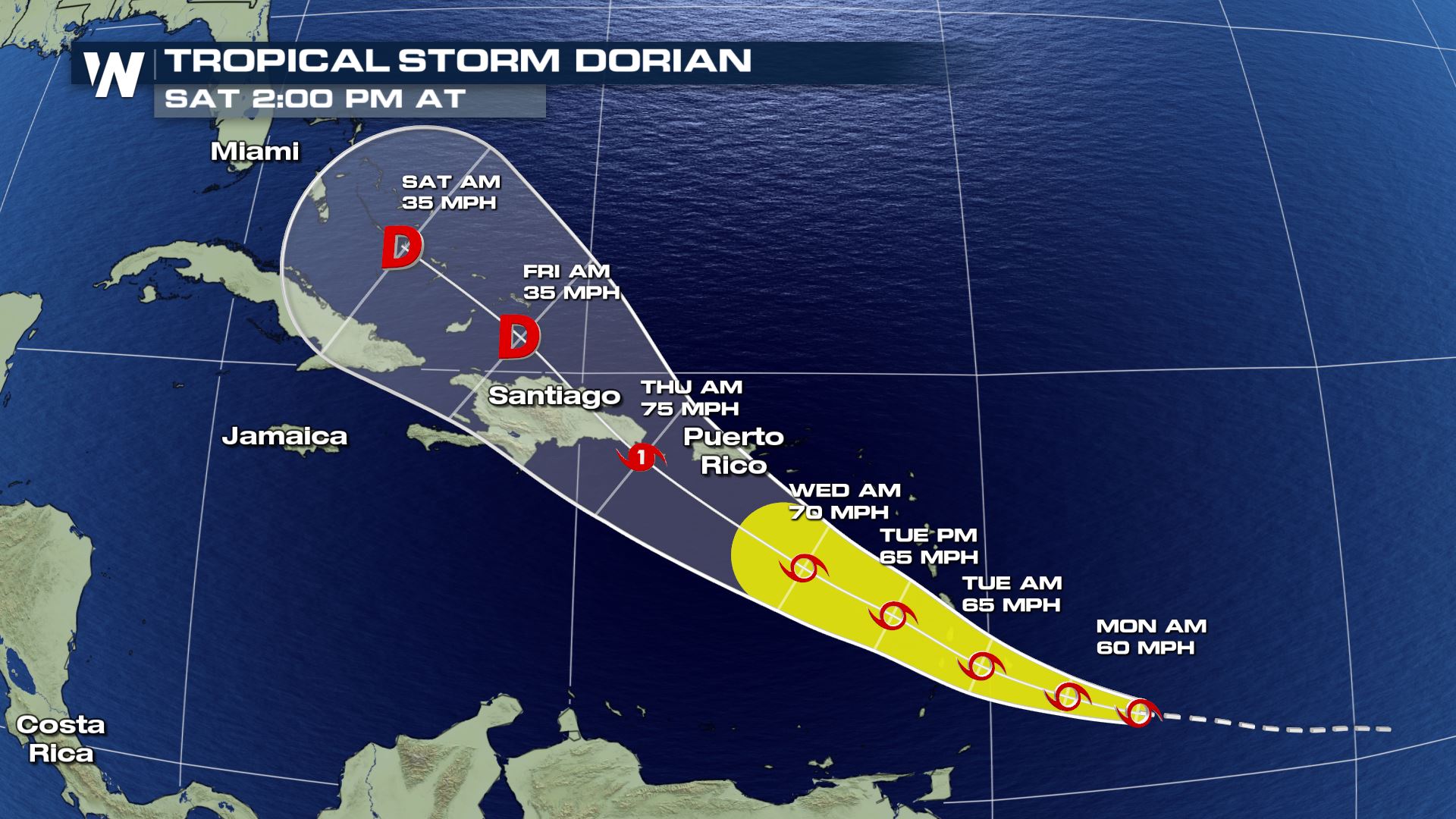 Keep in mind, the forecast fan relays uncertainty, so the storm center could be anywhere within the forecast fan, and changes may occur in the forecast details. Be sure to follow up each day.
[Related Video: Understanding the Forecast Cone]
We typically see tropical activity ramp up in the Atlantic Basin towards the end of August. Stick with WeatherNation online and on-air for continued updates.
Keep in mind, the forecast fan relays uncertainty, so the storm center could be anywhere within the forecast fan, and changes may occur in the forecast details. Be sure to follow up each day.
[Related Video: Understanding the Forecast Cone]
We typically see tropical activity ramp up in the Atlantic Basin towards the end of August. Stick with WeatherNation online and on-air for continued updates.
Tropical Alerts are in place for the Windward Islands. Additional watches or warnings may be issued for portions of the Leeward Islands Monday morning.
Tropical Storm Warnings are in place for Barbados, St. Lucia, St. Vincent and the Grenadines. Tropical storm force winds in excess of 39 mph will arrive in Barbados Monday and then continue westward.
In addition to strong winds, Dorian will also produce heavy rainfall across portions of the Lesser Antilles and Windward Islands. 2 to 4 inches of rainfall is expected, with isolated amounts as high as 6 inches.
Some gradual intensification is still expected over the next few days, despite the fact that this system will encounter some dry air and wind shear. Dorian may become a Category 1 hurricane by the middle of the week. Puerto Rico, the Virgin Islands, and Hispaniola should monitor the progression of Dorian over the next couple of days. It is still too early to pinpoint the time or magnitude of possible direct impacts.
Keep in mind, the forecast fan relays uncertainty, so the storm center could be anywhere within the forecast fan, and changes may occur in the forecast details. Be sure to follow up each day.
[Related Video: Understanding the Forecast Cone]
We typically see tropical activity ramp up in the Atlantic Basin towards the end of August. Stick with WeatherNation online and on-air for continued updates.All Weather News
More
Fronts Continue To Spark Severe Weather Across the Plains
A cold front that brought record lows to the
18 Jul 2025 10:40 PM

Extreme Heat Impacts for the East Coast & South
Extreme heat continues to impact several area
18 Jul 2025 10:05 PM

Flooding Threat Remains Elevated in the East
A cold front pushing through the Eastern Seab
18 Jul 2025 9:10 PM

EF-2 Firenado from the Deer Creek Fire in Utah
A fire tornado was spotted near La Sal, Utah
18 Jul 2025 7:30 AM

Tropical System Brings Flood Risk to the Central Gulf
Time has run out for notable tropical develop
18 Jul 2025 3:05 AM

Heavy Rain, Flooding Threat Returns to Florida
Keep the rain boots handy in Florida - heavy
13 Jul 2025 12:50 PM

Severe Storm Risk Pushes into the Great Lakes, Ohio Valley
Friday was another busy day with severe weath
12 Jul 2025 8:00 PM