Drought Expanding Across Southern California
Top Stories
15 Mar 2018 7:36 PM
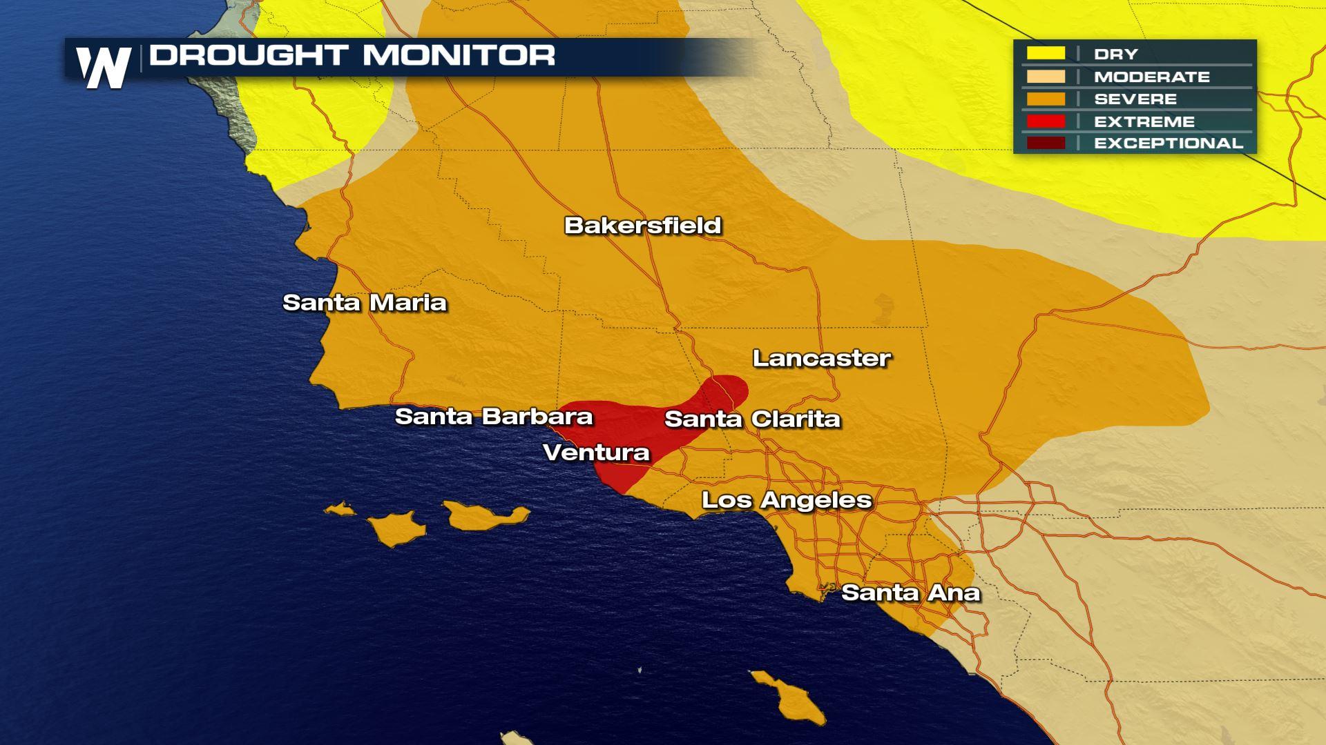
Even with recent rainfall, long-term statistics show that southern California continues to experience an expansion of drought conditions. In fact parts of the region are currently under what's deemed as "extreme drought."
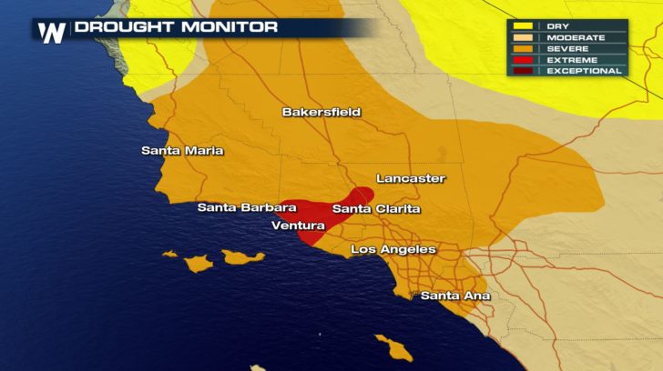 The drought monitor released Thursday, March 15. The data for this is valid through Tuesday, March 13.
Drought data looks longer-term and in this case, all the way back to October 1, 2017. The data is collected from October 1 until now to gather a summary of this area's "wet season." Typically, southern California receives most of its annual precipitation during the months of December, January, and February. But when we look at the stats from October, it tells a dry story.
The drought monitor released Thursday, March 15. The data for this is valid through Tuesday, March 13.
Drought data looks longer-term and in this case, all the way back to October 1, 2017. The data is collected from October 1 until now to gather a summary of this area's "wet season." Typically, southern California receives most of its annual precipitation during the months of December, January, and February. But when we look at the stats from October, it tells a dry story.
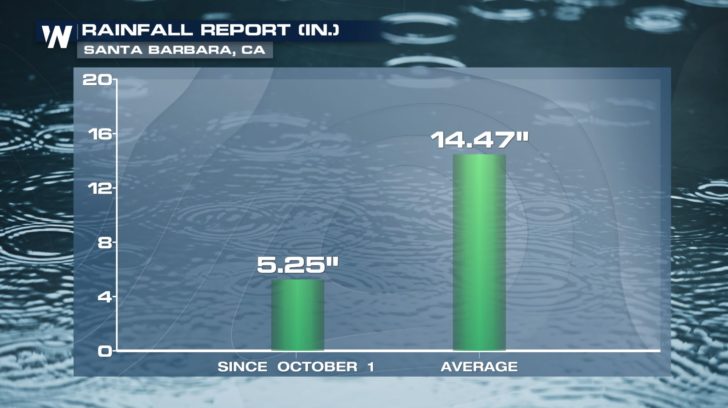
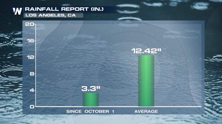
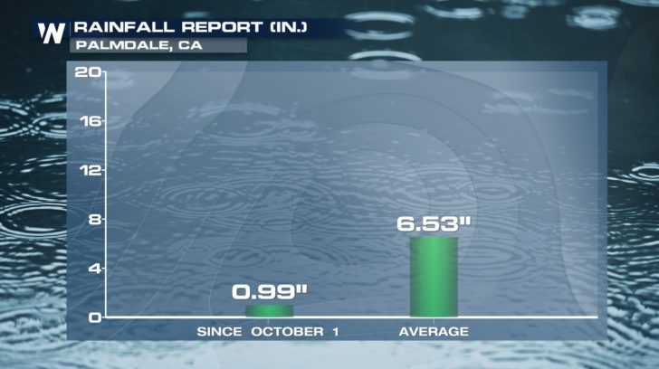 The columns on the left hand side above show the observed precipitation since October 1, compared to the average amount of precipitation during that time on the right. As you can see, the three locations selected are all running at around 15-30 percent of "normal." These average numbers are based on data collected between 1981-2010, commonly referred to as the climate period.
If the dry trend continues, we will have to worry about water levels and fire concerns heading into the summer/fall months. That's when it's typically much drier (on average) for this area.
Right now southern California is getting appreciable moisture. We have written extensively about the wet weather in the West with Meteorologist Matt Monroe. Just give this sentence a click or tap. When we look longer-term through the end of the month, the weather pattern favors wetter weather to continue, which in the short-term can help catch rain deficits up.
The columns on the left hand side above show the observed precipitation since October 1, compared to the average amount of precipitation during that time on the right. As you can see, the three locations selected are all running at around 15-30 percent of "normal." These average numbers are based on data collected between 1981-2010, commonly referred to as the climate period.
If the dry trend continues, we will have to worry about water levels and fire concerns heading into the summer/fall months. That's when it's typically much drier (on average) for this area.
Right now southern California is getting appreciable moisture. We have written extensively about the wet weather in the West with Meteorologist Matt Monroe. Just give this sentence a click or tap. When we look longer-term through the end of the month, the weather pattern favors wetter weather to continue, which in the short-term can help catch rain deficits up.
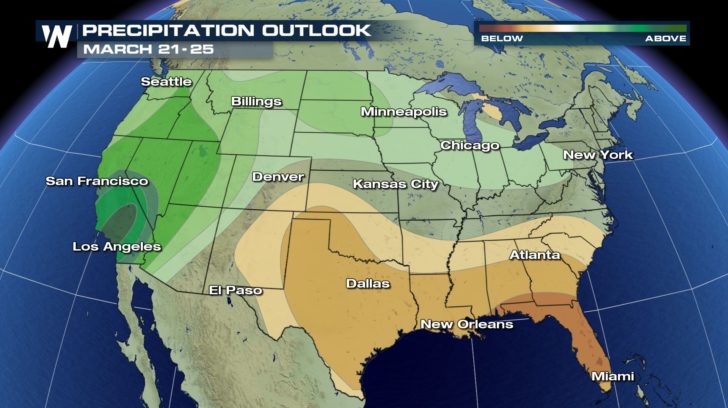 The chances of higher than average precipitation (greens) versus lower than average precipitation (browns) from Wednesday to Sunday, March 21-25.
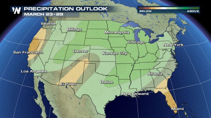 The chances of higher than average precipitation (greens) versus lower than average precipitation (browns) from Friday to Thursday, March 23-29.
Looking even deeper into the future for April, May, and June, the pattern unfortunately looks drier for California compared to average. Meteorologist Mace Michaels wrote extensively about that earlier and you can see his story here.
For WeatherNation, Meteorologist Steve Glazier
The chances of higher than average precipitation (greens) versus lower than average precipitation (browns) from Friday to Thursday, March 23-29.
Looking even deeper into the future for April, May, and June, the pattern unfortunately looks drier for California compared to average. Meteorologist Mace Michaels wrote extensively about that earlier and you can see his story here.
For WeatherNation, Meteorologist Steve Glazier
The drought monitor released Thursday, March 15. The data for this is valid through Tuesday, March 13.
Drought data looks longer-term and in this case, all the way back to October 1, 2017. The data is collected from October 1 until now to gather a summary of this area's "wet season." Typically, southern California receives most of its annual precipitation during the months of December, January, and February. But when we look at the stats from October, it tells a dry story.
The columns on the left hand side above show the observed precipitation since October 1, compared to the average amount of precipitation during that time on the right. As you can see, the three locations selected are all running at around 15-30 percent of "normal." These average numbers are based on data collected between 1981-2010, commonly referred to as the climate period.
If the dry trend continues, we will have to worry about water levels and fire concerns heading into the summer/fall months. That's when it's typically much drier (on average) for this area.
Right now southern California is getting appreciable moisture. We have written extensively about the wet weather in the West with Meteorologist Matt Monroe. Just give this sentence a click or tap. When we look longer-term through the end of the month, the weather pattern favors wetter weather to continue, which in the short-term can help catch rain deficits up.
The chances of higher than average precipitation (greens) versus lower than average precipitation (browns) from Wednesday to Sunday, March 21-25.
The chances of higher than average precipitation (greens) versus lower than average precipitation (browns) from Friday to Thursday, March 23-29.
Looking even deeper into the future for April, May, and June, the pattern unfortunately looks drier for California compared to average. Meteorologist Mace Michaels wrote extensively about that earlier and you can see his story here.
For WeatherNation, Meteorologist Steve GlazierAll Weather News
More
East Gears Up for Stormy, Wet Weekend
A low pressure system crashing through the Mi
1 Aug 2026 11:35 AM


Flooding, Severe Storms Target the Midwest Again
After an active week of storms across the nor
1 Aug 2026 1:40 AM


After Reaching Category 5, Genevieve Weakens in the Pacific
PacificFausto is now a post-tropical cyclone.
31 Jul 2026 1:30 AM

Flooding Risk Increases as Heavy Rain Targets the Tri-State Area
Tuesday, heavy rainfall moved across the Nort
30 Jul 2026 12:25 AM

Severe Weather: Energy From the Midwest Now in the Southeast
UPPER MIDWEST - Through Monday, dangerous tor
29 Jul 2026 10:30 PM