Dry Thunderstorms Forecast Today. Wait, Dry Storms?
Top Stories
2 Jun 2021 12:00 PM
If you've never come across the term, you may be wondering, "What exactly is a dry thunderstorm?" We're glad you asked (even if you didn't!) Fortunately I was able to whip up this short, educational video just in time for the article.
https://youtu.be/9PtlVfUEX-Q
Now that we understand dry thunderstorms a little better, let's discuss when and where we're expecting them on Thursday, June 3rd.
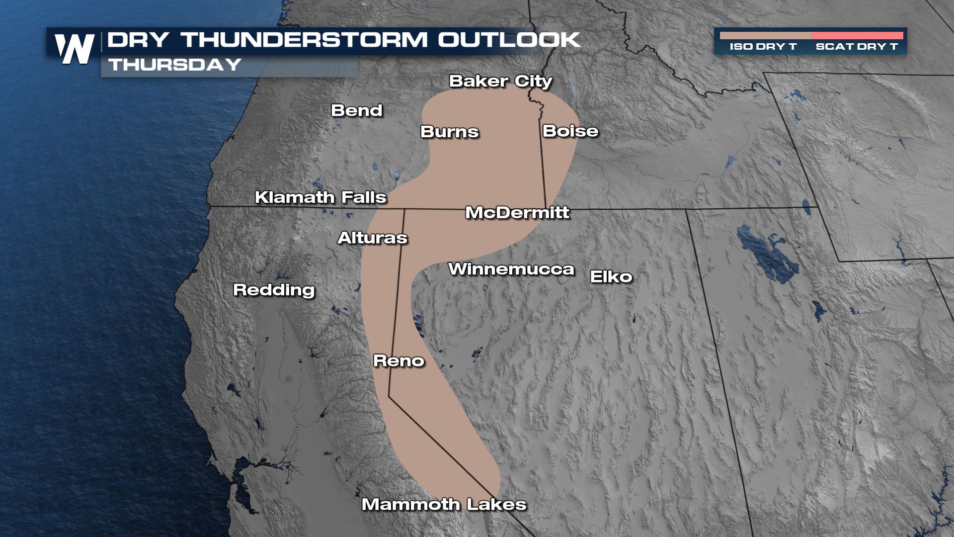 The Dry Thunderstorm outlook for Fire Weather Thursday, June 3rd ranges from eastern Oregon to extreme southwestern Idaho, western Nevada and California's Sierra Crest.
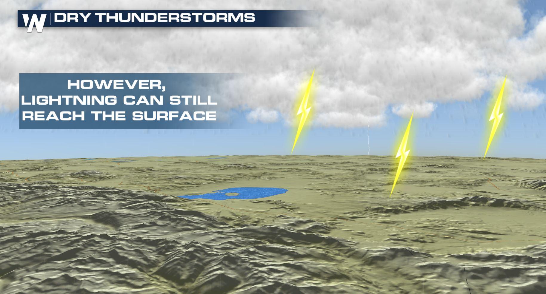
The brown shaded area you see here is for ISO DRYT. That stands for Isolated Dry Thunderstorms. Remember, that's *less than* scattered. Whenever you hear a forecast, scattered will mean more than isolated (example scattered showers versus isolated showers). According to the demonstration above, that means that high-based clouds will develop, some may grow tall/strong enough to produce lightning and thus, dry thunderstorms. While the dry thunderstorm forecast is for parts of California and Oregon, the Desert Southwest is notorious for dry thunderstorms because of the extremely dry climate, mixed with thunderstorms that develop closer to the monsoon season.
Related Article: Monsoon Season 2020: Another Non-Soon Season
In the case of California, Oregon, Nevada, and Idaho Thursday, the fuels are incredibly dry. What we mean by "fuels" is the grass, shrubs, vegetation which have had a severe lack of water after this most-recent dry winter. A lightning strike could spark a blaze if a bolt hits one of these dry spots.
The biggest concern with dry thunderstorms is the development of new wildfires. Much of the West is experiencing drought conditions as well, which will be a story that we stay on top of throughout these warmer months.
For WeatherNation, Meteorologist Steve Glazier
The Dry Thunderstorm outlook for Fire Weather Thursday, June 3rd ranges from eastern Oregon to extreme southwestern Idaho, western Nevada and California's Sierra Crest.
The brown shaded area you see here is for ISO DRYT. That stands for Isolated Dry Thunderstorms. Remember, that's *less than* scattered. Whenever you hear a forecast, scattered will mean more than isolated (example scattered showers versus isolated showers). According to the demonstration above, that means that high-based clouds will develop, some may grow tall/strong enough to produce lightning and thus, dry thunderstorms. While the dry thunderstorm forecast is for parts of California and Oregon, the Desert Southwest is notorious for dry thunderstorms because of the extremely dry climate, mixed with thunderstorms that develop closer to the monsoon season.
Related Article: Monsoon Season 2020: Another Non-Soon Season
In the case of California, Oregon, Nevada, and Idaho Thursday, the fuels are incredibly dry. What we mean by "fuels" is the grass, shrubs, vegetation which have had a severe lack of water after this most-recent dry winter. A lightning strike could spark a blaze if a bolt hits one of these dry spots.
The biggest concern with dry thunderstorms is the development of new wildfires. Much of the West is experiencing drought conditions as well, which will be a story that we stay on top of throughout these warmer months.
For WeatherNation, Meteorologist Steve GlazierAll Weather News
More
Wildfire Outbreak in the Pacific Northwest
SPOKANE, WA - On Saturday, August 1st, the Ol
3 Aug 2026 1:55 AM

More Storms for the East Through Monday
A low-pressure system that moved through the
3 Aug 2026 1:50 AM


After Reaching Category 5, Genevieve Weakens in the Pacific
PacificGenevieve formed last Friday south of
3 Aug 2026 12:30 AM

Flooding, Severe Storms Target the Midwest Again
After an active week of storms across the nor
1 Aug 2026 1:40 AM

Flooding Risk Increases as Heavy Rain Targets the Tri-State Area
Tuesday, heavy rainfall moved across the Nort
30 Jul 2026 12:25 AM

Severe Weather: Energy From the Midwest Now in the Southeast
UPPER MIDWEST - Through Monday, dangerous tor
29 Jul 2026 10:30 PM