Dust Detection System Debuts in Phoenix in Time for Monsoon Season
Special Stories
10 Jun 2020 11:15 AM
Monsoon season in the Desert Southwest means the return of thunderstorms and the hazards that accompany those storms. Flash flooding and lightning pose serious threats, but so do strong winds that can knock down trees or kick up blinding walls of dust, also known as haboobs (read more about what they are and how they form at the bottom of this article).
With the start of monsoon season just days away (June 15th), meteorologists and officials in Arizona will have a new tool at their disposal this year to help improve in the detection and warning process for dust storms. These storms can reduce visibility to less than a few hundred feet in a matter of minutes, posing a serious threat to safety, especially on the road.
[embed]https://twitter.com/ArizonaDOT/status/1270509734349746178[/embed]
The Arizona Department of Transportation (ADOT) issued this release on Tuesday along with a short video on twitter (above) which show off the new equipment placed along a ten mile stretch of I-10 between Phoenix and Tucson.
Between mileposts 209 and 219, thirteen sensors have been installed that use light beams to monitor visibility and the density of dust particles. These are complemented by a new X-Band radar, which will help fill in some holes in the radar data that's currently available.
Speaking to WeatherNation in a phone call on Wednesday morning, Isaac Smith, meteorologist with the National Weather Service in Phoenix, said this corridor can be difficult to monitor on radar due to blockage from buildings and varied terrain.
It's also been the site of multiple pile-ups in the past which occurred during dust storms, at least two of which have resulted in fatalities.
This new information will be utilized by both the ADOT and branches of the National Weather Service in Phoenix and Tucson to help improve warnings, which can be relayed to the public via new message boards. Variable speed limits will also be implemented when the system kicks on during a dust storm.
The system just finished a 30 day trial period and is now operational. ADOT will use information gained through this pilot program to determine if similar technologies would be useful along other stretches of highway.
If you find yourself on the road when a dust storm rolls in, immediately check the traffic around you and begin slowing down. Pull your vehicle completely off the roadway (exit the highway if possible) as soon as it is safe to do so. Turn off all lights and emergency flashers. Set the parking brake and remove your foot from the brake. Wait in the car with your seat belt on until the storm passes. For more information visit PullAsideStayAlive.
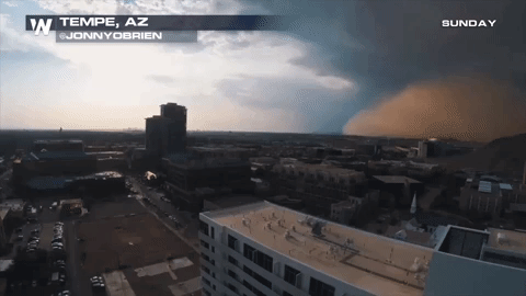
So, what is a haboob and how do they work?
[embed]https://www.youtube.com/watch?v=sFKqJOTp_S4[/embed]
I'm glad you asked.
Haboob is the term given to an intense sandstorm created by powerful winds (read the full AMS definition here). These winds are typically caused by the outflow of a thunderstorm (the downdraft) but can also be created by larger scale wind patterns. The haboob in the video above blew through Phoenix on August 9th, 2016.
These dust storms increase in frequency in the Desert Southwest during monsoon season, when afternoon thunderstorms occur almost daily. The sand from these storms can tower up to a mile high and move as fast as 60 mph.
Meteorologist Chris Bianchi provides a great explanation of the phenomena in the video below.
[embed]https://www.youtube.com/watch?v=a1ByUnWijrs[/embed]
All Weather News
More
Fronts Continue To Spark Severe Weather Across the Plains
A cold front that brought record lows to the
18 Jul 2025 10:40 PM

Extreme Heat Impacts for the East Coast & South
Extreme heat continues to impact several area
18 Jul 2025 10:05 PM

Flooding Threat Remains Elevated in the East
A cold front pushing through the Eastern Seab
18 Jul 2025 9:10 PM

EF-2 Firenado from the Deer Creek Fire in Utah
A fire tornado was spotted near La Sal, Utah
18 Jul 2025 7:30 AM

Tropical System Brings Flood Risk to the Central Gulf
Time has run out for notable tropical develop
18 Jul 2025 3:05 AM

Heavy Rain, Flooding Threat Returns to Florida
Keep the rain boots handy in Florida - heavy
13 Jul 2025 12:50 PM

Severe Storm Risk Pushes into the Great Lakes, Ohio Valley
Friday was another busy day with severe weath
12 Jul 2025 8:00 PM