Early Warning Earthquake System Tested against Chilean Great Quakes
Special Stories
8 Feb 2018 10:16 AM
[The Epicenter of the 2010 Chile earthquake near Concepción. By Claudio Núñez from CC by SA 2.0]
From Seismological Society of America
Researchers testing a satellite-based earthquake early warning system developed for the U.S. West Coast found that the system performed well in a “replay” of three large earthquakes that occurred in Chile between 2010 and 2015. Their results, reported in the journal Seismological Research Letters, suggest that such a system could provide early warnings of ground shaking and tsunamis for Chile’s coastal communities in the future.
The early warning module, called G-FAST, uses ground motion data measured by Global Navigation Satellite Systems (GNSS) to estimate the magnitude and epicenter for large earthquakes–those magnitude 8 and greater. These great quakes often take place at subducting tectonic plate boundaries, where one plate thrusts beneath another plate, as is the case off the coast of Chile and the U.S. Pacific Northwest.
Using data collected by Chile’s more than 150 GNSS stations, Brendan Crowell of the University of Washington and his colleagues tested G-FAST’s performance against three large megathrust earthquakes in the country: the 2010 magnitude 8.8 Maule, the 2014 magnitude 8.2 Iquique, and the 2015 magnitude 8.3 Illapel earthquakes.
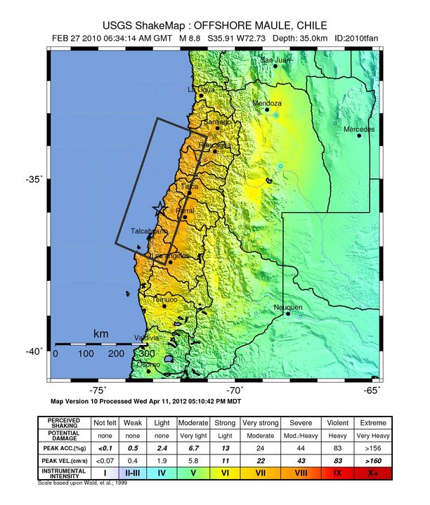
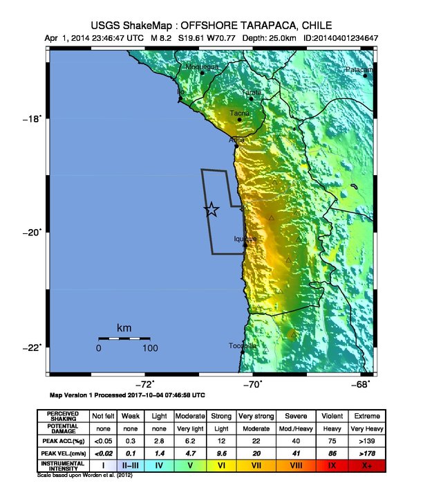
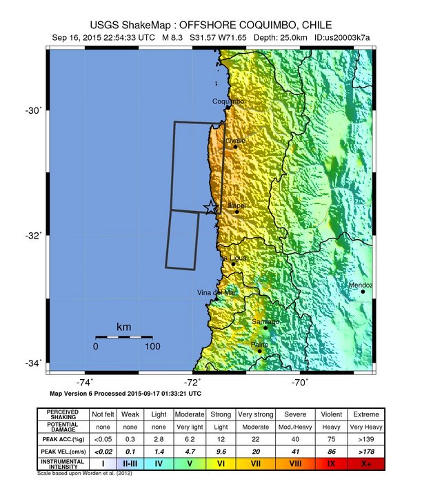 [Shake maps from the three earthquakes from 2010-2015 in Chile. From the USGS]
G-FAST was able to provide magnitude estimates between 40 to 60 seconds after the origin time of all three quakes, providing magnitude estimates that were within 0.3 units of the known magnitudes. The system also provided estimates of the epicenter and fault slip for each earthquake that agreed with the actual measurements, and were available 60 to 90 seconds after each earthquake’s origin time. “We were surprised at how fast G-FAST was able to converge to the correct answers and how accurately we were able to characterize all three earthquakes,” said Crowell.
Most earthquake early warning systems measure properties of seismic waves to quickly characterize an earthquake. These systems often cannot collect enough information to determine how a large earthquake will grow and as a result may underestimate the earthquake magnitude–a problem that can be avoided with satellite-based systems such as G-FAST.
[Shake maps from the three earthquakes from 2010-2015 in Chile. From the USGS]
G-FAST was able to provide magnitude estimates between 40 to 60 seconds after the origin time of all three quakes, providing magnitude estimates that were within 0.3 units of the known magnitudes. The system also provided estimates of the epicenter and fault slip for each earthquake that agreed with the actual measurements, and were available 60 to 90 seconds after each earthquake’s origin time. “We were surprised at how fast G-FAST was able to converge to the correct answers and how accurately we were able to characterize all three earthquakes,” said Crowell.
Most earthquake early warning systems measure properties of seismic waves to quickly characterize an earthquake. These systems often cannot collect enough information to determine how a large earthquake will grow and as a result may underestimate the earthquake magnitude–a problem that can be avoided with satellite-based systems such as G-FAST.
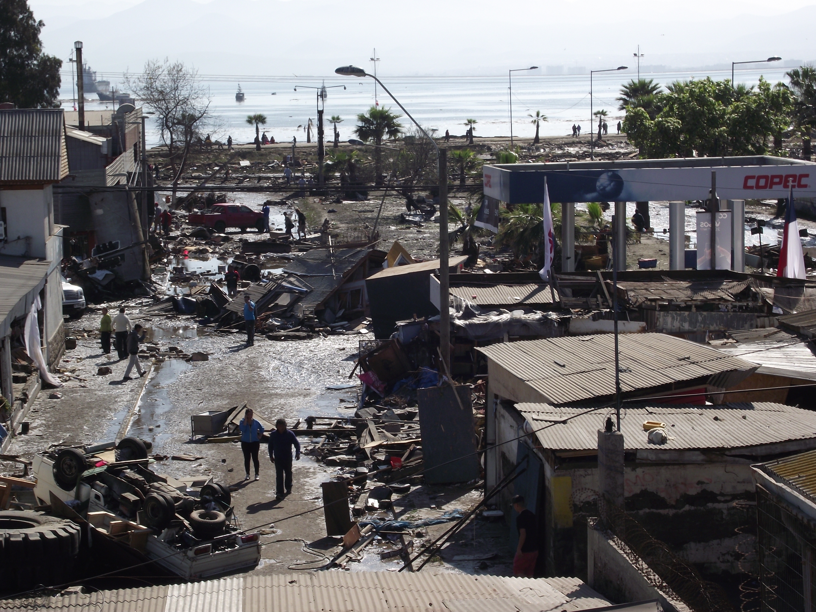 [Street scene near the coast in Coquimbo, Chile in the 2014 quake and tsunami aftermath. By SFS90 from CC by SA 4.0]
It’s difficult to test these types of early warning systems, Crowell noted, because magnitude 8+ earthquakes are relatively rare. “We decided to look at the Chilean earthquakes because they included several greater than magnitude 8 earthquakes, recorded with an excellent and consistent GNSS network. In doing so, we would be able to better categorize the strengths and weaknesses in G-FAST.”
The Chilean tests will play a part in furthering developing G-FAST for use in the U.S., where Crowell and colleagues have been working to include it in the prototype earthquake early warning system called ShakeAlert, now operating in California, Oregon and Washington. The Chilean earthquakes, Crowell said, represent about half of magnitude 8 events in the recorded catalog of earthquakes that are used to test G-FAST and other geodetic algorithms for inclusion in ShakeAlert.
Ten magnitude 8 or greater earthquakes have occurred along the Chilean coast in the past 100 years, including the 1960 magnitude 9.5 Valdivia earthquake, which is the largest earthquake recorded by instruments.
[Street scene near the coast in Coquimbo, Chile in the 2014 quake and tsunami aftermath. By SFS90 from CC by SA 4.0]
It’s difficult to test these types of early warning systems, Crowell noted, because magnitude 8+ earthquakes are relatively rare. “We decided to look at the Chilean earthquakes because they included several greater than magnitude 8 earthquakes, recorded with an excellent and consistent GNSS network. In doing so, we would be able to better categorize the strengths and weaknesses in G-FAST.”
The Chilean tests will play a part in furthering developing G-FAST for use in the U.S., where Crowell and colleagues have been working to include it in the prototype earthquake early warning system called ShakeAlert, now operating in California, Oregon and Washington. The Chilean earthquakes, Crowell said, represent about half of magnitude 8 events in the recorded catalog of earthquakes that are used to test G-FAST and other geodetic algorithms for inclusion in ShakeAlert.
Ten magnitude 8 or greater earthquakes have occurred along the Chilean coast in the past 100 years, including the 1960 magnitude 9.5 Valdivia earthquake, which is the largest earthquake recorded by instruments.
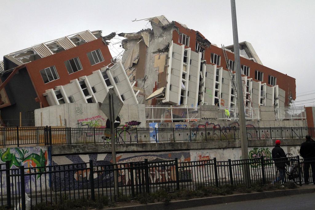
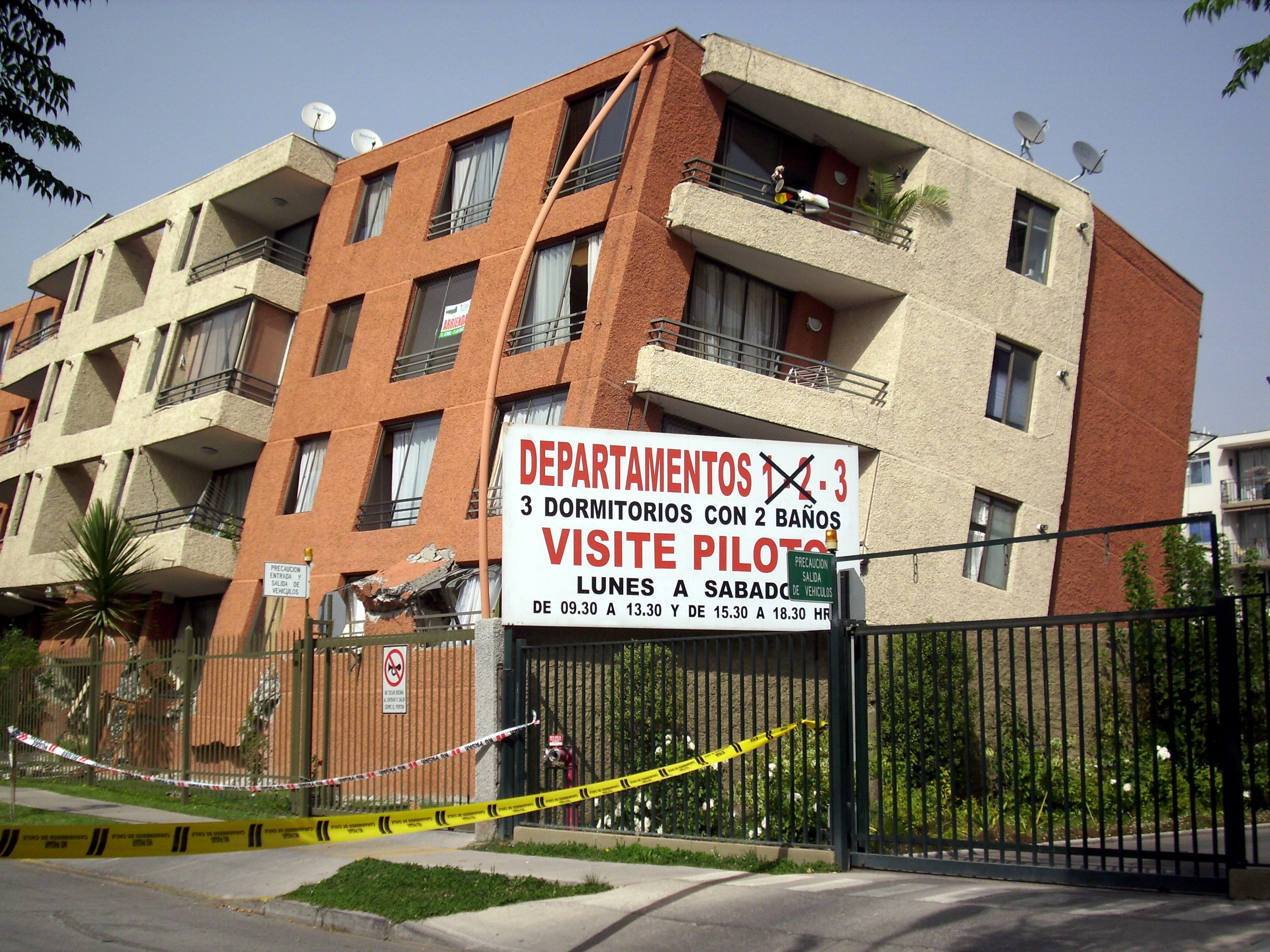 [A severely damaged building in Maipú, Santiago after the 2010 earthquake. From Jorge Barrios by CC BY-SA 3.0]
After the 2010 Maule earthquake, the country began installing a network of digital broadband seismic and ground motion stations, Global Positioning System stations, and GNSS stations to provide accurate information for tsunami warnings and damage assessment. Since 2012, the Centro Sismológico Nacional at the Universidad de Chile has operated more than 100 stations, and has recently begun to operate almost 300 strong-motion accelerometers that measure ground shaking.
In a second paper published in SRL, Felipe Leyton of the Universidad de Chile and colleagues analyze data collected from 163 of these strong-motion stations to learn more about the local site conditions of underlying rock and soil in these areas. Site conditions can modify the shaking of large earthquakes and control the damage to buildings and other infrastructure caused by the shaking. The new study “gives us a unique opportunity to improve our knowledge of the behavior of soil deposits during earthquakes, especially in urbanized areas,” write Leyton and colleagues, who say the data could be used to help improve building designs and codes.
[A severely damaged building in Maipú, Santiago after the 2010 earthquake. From Jorge Barrios by CC BY-SA 3.0]
After the 2010 Maule earthquake, the country began installing a network of digital broadband seismic and ground motion stations, Global Positioning System stations, and GNSS stations to provide accurate information for tsunami warnings and damage assessment. Since 2012, the Centro Sismológico Nacional at the Universidad de Chile has operated more than 100 stations, and has recently begun to operate almost 300 strong-motion accelerometers that measure ground shaking.
In a second paper published in SRL, Felipe Leyton of the Universidad de Chile and colleagues analyze data collected from 163 of these strong-motion stations to learn more about the local site conditions of underlying rock and soil in these areas. Site conditions can modify the shaking of large earthquakes and control the damage to buildings and other infrastructure caused by the shaking. The new study “gives us a unique opportunity to improve our knowledge of the behavior of soil deposits during earthquakes, especially in urbanized areas,” write Leyton and colleagues, who say the data could be used to help improve building designs and codes.
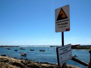 [A satellite-based early warning system could someday provide more warning for tsunamis along the Chilean coast. Photo credit: Stephen Hicks]
esearchers testing a satellite-based earthquake early warning system developed for the U.S. West Coast found that the system performed well in a “replay” of three large earthquakes that occurred in Chile between 2010 and 2015. Their results, reported in the journal Seismological Research Letters, suggest that such a system could provide early warnings of ground shaking and tsunamis for Chile’s coastal communities in the future.
Edited for WeatherNation by Meteorologist Mace Michaels
[A satellite-based early warning system could someday provide more warning for tsunamis along the Chilean coast. Photo credit: Stephen Hicks]
esearchers testing a satellite-based earthquake early warning system developed for the U.S. West Coast found that the system performed well in a “replay” of three large earthquakes that occurred in Chile between 2010 and 2015. Their results, reported in the journal Seismological Research Letters, suggest that such a system could provide early warnings of ground shaking and tsunamis for Chile’s coastal communities in the future.
Edited for WeatherNation by Meteorologist Mace Michaels
[Shake maps from the three earthquakes from 2010-2015 in Chile. From the USGS]
G-FAST was able to provide magnitude estimates between 40 to 60 seconds after the origin time of all three quakes, providing magnitude estimates that were within 0.3 units of the known magnitudes. The system also provided estimates of the epicenter and fault slip for each earthquake that agreed with the actual measurements, and were available 60 to 90 seconds after each earthquake’s origin time. “We were surprised at how fast G-FAST was able to converge to the correct answers and how accurately we were able to characterize all three earthquakes,” said Crowell.
Most earthquake early warning systems measure properties of seismic waves to quickly characterize an earthquake. These systems often cannot collect enough information to determine how a large earthquake will grow and as a result may underestimate the earthquake magnitude–a problem that can be avoided with satellite-based systems such as G-FAST.
[Street scene near the coast in Coquimbo, Chile in the 2014 quake and tsunami aftermath. By SFS90 from CC by SA 4.0]
It’s difficult to test these types of early warning systems, Crowell noted, because magnitude 8+ earthquakes are relatively rare. “We decided to look at the Chilean earthquakes because they included several greater than magnitude 8 earthquakes, recorded with an excellent and consistent GNSS network. In doing so, we would be able to better categorize the strengths and weaknesses in G-FAST.”
The Chilean tests will play a part in furthering developing G-FAST for use in the U.S., where Crowell and colleagues have been working to include it in the prototype earthquake early warning system called ShakeAlert, now operating in California, Oregon and Washington. The Chilean earthquakes, Crowell said, represent about half of magnitude 8 events in the recorded catalog of earthquakes that are used to test G-FAST and other geodetic algorithms for inclusion in ShakeAlert.
Ten magnitude 8 or greater earthquakes have occurred along the Chilean coast in the past 100 years, including the 1960 magnitude 9.5 Valdivia earthquake, which is the largest earthquake recorded by instruments.
[A severely damaged building in Maipú, Santiago after the 2010 earthquake. From Jorge Barrios by CC BY-SA 3.0]
After the 2010 Maule earthquake, the country began installing a network of digital broadband seismic and ground motion stations, Global Positioning System stations, and GNSS stations to provide accurate information for tsunami warnings and damage assessment. Since 2012, the Centro Sismológico Nacional at the Universidad de Chile has operated more than 100 stations, and has recently begun to operate almost 300 strong-motion accelerometers that measure ground shaking.
In a second paper published in SRL, Felipe Leyton of the Universidad de Chile and colleagues analyze data collected from 163 of these strong-motion stations to learn more about the local site conditions of underlying rock and soil in these areas. Site conditions can modify the shaking of large earthquakes and control the damage to buildings and other infrastructure caused by the shaking. The new study “gives us a unique opportunity to improve our knowledge of the behavior of soil deposits during earthquakes, especially in urbanized areas,” write Leyton and colleagues, who say the data could be used to help improve building designs and codes.
[A satellite-based early warning system could someday provide more warning for tsunamis along the Chilean coast. Photo credit: Stephen Hicks]
esearchers testing a satellite-based earthquake early warning system developed for the U.S. West Coast found that the system performed well in a “replay” of three large earthquakes that occurred in Chile between 2010 and 2015. Their results, reported in the journal Seismological Research Letters, suggest that such a system could provide early warnings of ground shaking and tsunamis for Chile’s coastal communities in the future.
Edited for WeatherNation by Meteorologist Mace MichaelsAll Weather News
More
Nor'Easter Riles up the Waves This Week
SETUPAn upper-level low broke off from the fl
21 Oct 2026 11:50 AM

Severe Weather & Heavy Rainfall Aims for the West This Week
Looking ahead to this week, a low-pressure sy
21 Oct 2026 11:40 AM


Warmer Than Average: Above-Normal Temperatures Across the Central U.S. This Week
WHAT TO EXPECTA ridge of high pressure will b
21 Oct 2026 11:20 AM

Several Fires Break Out in SoCal Last Week Amid Santa Ana Wind Event
Santa Ana winds helped several fires grow qui
19 Oct 2026 1:25 PM

Another Cold Morning Before Things Warm Back Up
Across portions of the Ohio Valley through th
19 Oct 2026 10:15 AM

Severe Risk Diminishing Saturday Morning for the Northeast
Severe Storm PotentialSevere risk is decreasi
16 Oct 2026 10:20 AM