Eddies Off The California Coast Form Hurricane-Esque Eye
Special Stories
24 Apr 2018 11:50 AM
Everyone recognizes the eye of a hurricane. It’s a remarkable yet terrifying image. But what about its little cousin, the von Kármán vortex?
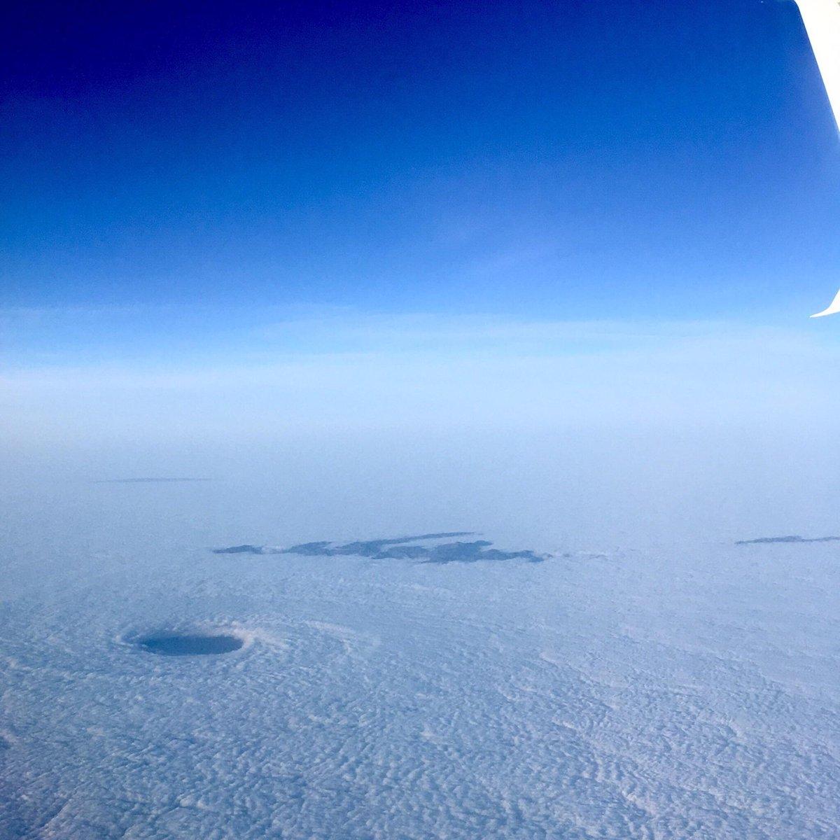
 [The swirling eddy as seen from a plane, early Monday morning. Credit: Reddit user "gedimin"]
Early on Monday morning Reddit user “gedimin” snapped an incredible photo of a vortex off the Southern California coast. This swirling eye was embedded in a stratus cloud deck that commonly inhabits the Los Angeles coastline. At a glance, this eddy has features that resemble a hurricane but in reality the dynamics that form these vortices have nothing to do with the tropics.
The twisting begins as air is forced up against higher terrain, giving it two options: up and over or around the sides. When the air goes around the side, the friction between the air and land causes the wind to change speed and direction. As the wind changes speed and direction, it begins to rotate.
[The swirling eddy as seen from a plane, early Monday morning. Credit: Reddit user "gedimin"]
Early on Monday morning Reddit user “gedimin” snapped an incredible photo of a vortex off the Southern California coast. This swirling eye was embedded in a stratus cloud deck that commonly inhabits the Los Angeles coastline. At a glance, this eddy has features that resemble a hurricane but in reality the dynamics that form these vortices have nothing to do with the tropics.
The twisting begins as air is forced up against higher terrain, giving it two options: up and over or around the sides. When the air goes around the side, the friction between the air and land causes the wind to change speed and direction. As the wind changes speed and direction, it begins to rotate.
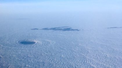
 [A von Kármán vortice sloshing in the SoCal marine layer. Credit: College of Dupage Meteorology]
In this case, the air was forced around one of the Channel Islands of California but these vortices can form in a variety of regions across the globe. A von Kármán hot spot is the Canary Islands which are regularly frequented by these beautiful swirls.
When the wind is persistent enough, these vortices feed off of each other resulting in a von Kármán vortex street. As you might imagine, the visual is stunning.
[A von Kármán vortice sloshing in the SoCal marine layer. Credit: College of Dupage Meteorology]
In this case, the air was forced around one of the Channel Islands of California but these vortices can form in a variety of regions across the globe. A von Kármán hot spot is the Canary Islands which are regularly frequented by these beautiful swirls.
When the wind is persistent enough, these vortices feed off of each other resulting in a von Kármán vortex street. As you might imagine, the visual is stunning.
 [Three rows of von Kármán vortex streets off the African coast. Credit: NASA Earth Observatory]
So the next time you’re flying over the California coastline, look down and see if you can find these “stratocanes” lurking at sea.
Written by: Dakota Smith.
[Three rows of von Kármán vortex streets off the African coast. Credit: NASA Earth Observatory]
So the next time you’re flying over the California coastline, look down and see if you can find these “stratocanes” lurking at sea.
Written by: Dakota Smith.
[The swirling eddy as seen from a plane, early Monday morning. Credit: Reddit user "gedimin"]
Early on Monday morning Reddit user “gedimin” snapped an incredible photo of a vortex off the Southern California coast. This swirling eye was embedded in a stratus cloud deck that commonly inhabits the Los Angeles coastline. At a glance, this eddy has features that resemble a hurricane but in reality the dynamics that form these vortices have nothing to do with the tropics.
The twisting begins as air is forced up against higher terrain, giving it two options: up and over or around the sides. When the air goes around the side, the friction between the air and land causes the wind to change speed and direction. As the wind changes speed and direction, it begins to rotate.
[A von Kármán vortice sloshing in the SoCal marine layer. Credit: College of Dupage Meteorology]
In this case, the air was forced around one of the Channel Islands of California but these vortices can form in a variety of regions across the globe. A von Kármán hot spot is the Canary Islands which are regularly frequented by these beautiful swirls.
When the wind is persistent enough, these vortices feed off of each other resulting in a von Kármán vortex street. As you might imagine, the visual is stunning.
[Three rows of von Kármán vortex streets off the African coast. Credit: NASA Earth Observatory]
So the next time you’re flying over the California coastline, look down and see if you can find these “stratocanes” lurking at sea.
Written by: Dakota Smith.All Weather News
More
Fronts Continue To Spark Severe Weather Across the Plains
A cold front that brought record lows to the
18 Jul 2025 10:40 PM

Extreme Heat Impacts for the East Coast & South
Extreme heat continues to impact several area
18 Jul 2025 10:05 PM

Flooding Threat Remains Elevated in the East
A cold front pushing through the Eastern Seab
18 Jul 2025 9:10 PM

EF-2 Firenado from the Deer Creek Fire in Utah
A fire tornado was spotted near La Sal, Utah
18 Jul 2025 7:30 AM

Tropical System Brings Flood Risk to the Central Gulf
Time has run out for notable tropical develop
18 Jul 2025 3:05 AM

Heavy Rain, Flooding Threat Returns to Florida
Keep the rain boots handy in Florida - heavy
13 Jul 2025 12:50 PM

Severe Storm Risk Pushes into the Great Lakes, Ohio Valley
Friday was another busy day with severe weath
12 Jul 2025 8:00 PM