Enhanced Risk of Severe Thunderstorms Wednesday
Top Stories
18 Jul 2018 6:10 AM
Thunderstorms are forecast to develop across parts of the central Plains Wednesday afternoon and evening, some packing powerful wind and isolated tornadoes.
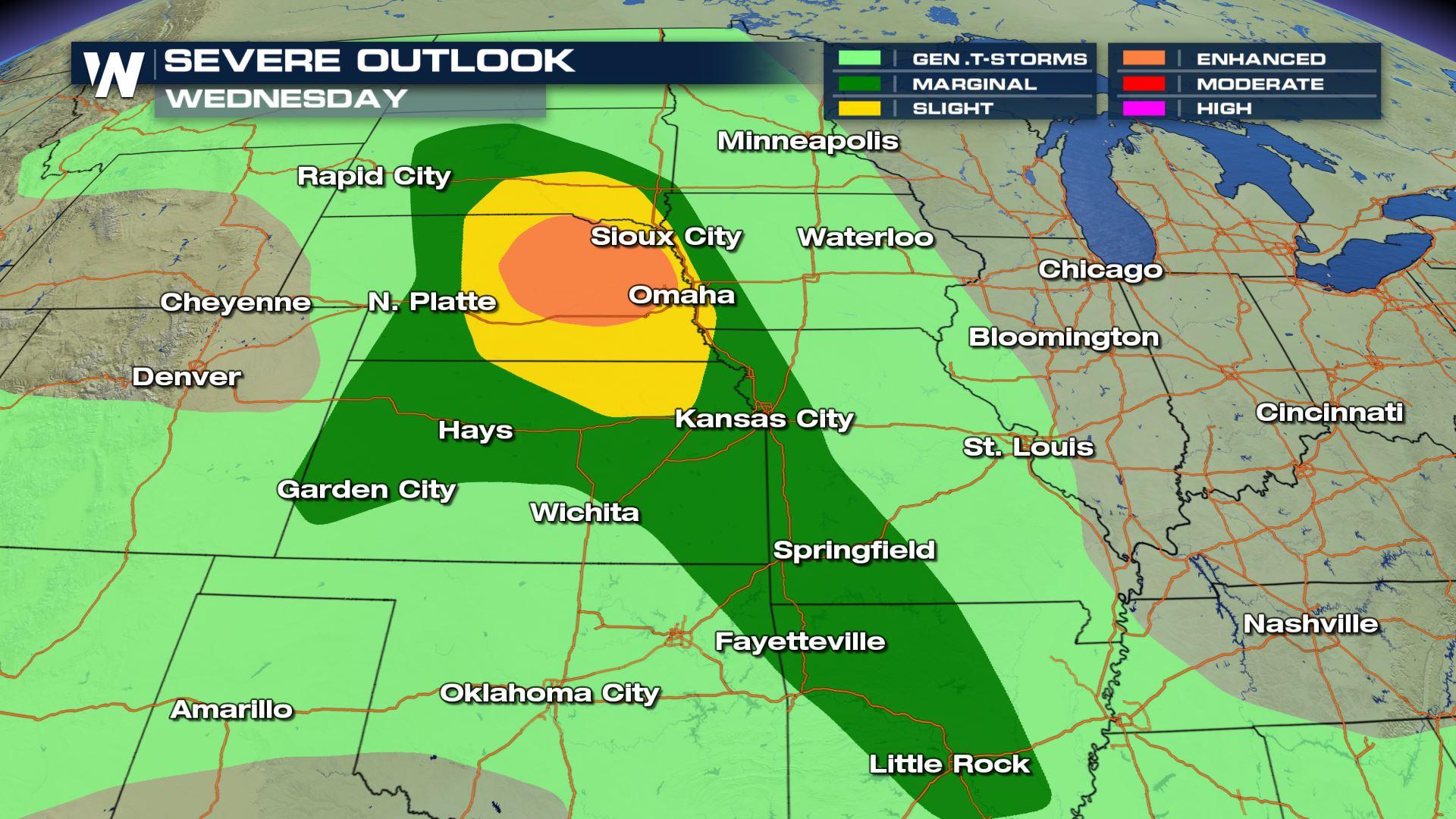
 The severe weather outlook for Wednesday, July 18
Dark green, yellow, and orange areas will be at greatest risk of severe thunderstorms Wednesday.
The severe weather outlook for Wednesday, July 18
Dark green, yellow, and orange areas will be at greatest risk of severe thunderstorms Wednesday.
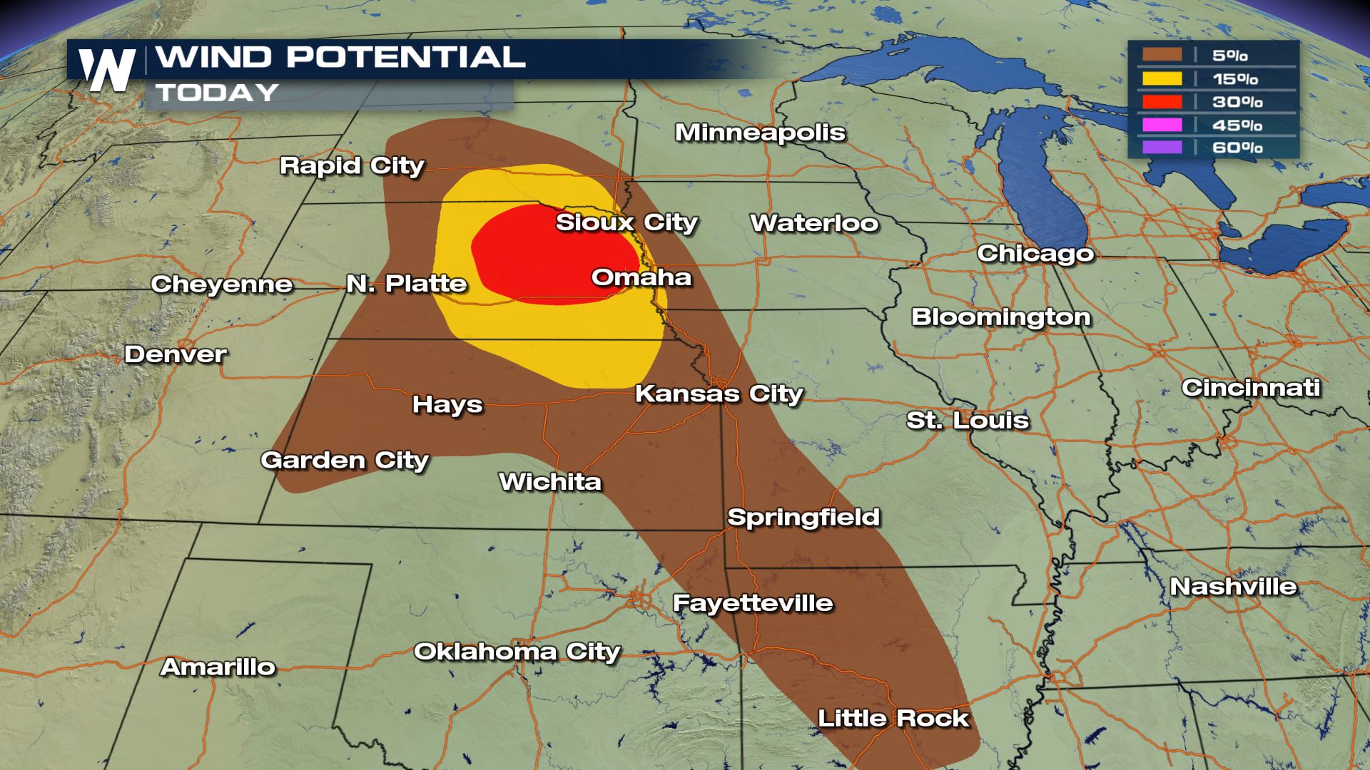 The damaging wind potential on Wednesday, July 18
The greatest severe potential will be damaging wind gusts, from parts of South Dakota through Nebraska and parts of Kansas. These are the areas that may experience isolated power outages from strong winds, along with debris from the storm gusts.
The damaging wind potential on Wednesday, July 18
The greatest severe potential will be damaging wind gusts, from parts of South Dakota through Nebraska and parts of Kansas. These are the areas that may experience isolated power outages from strong winds, along with debris from the storm gusts.
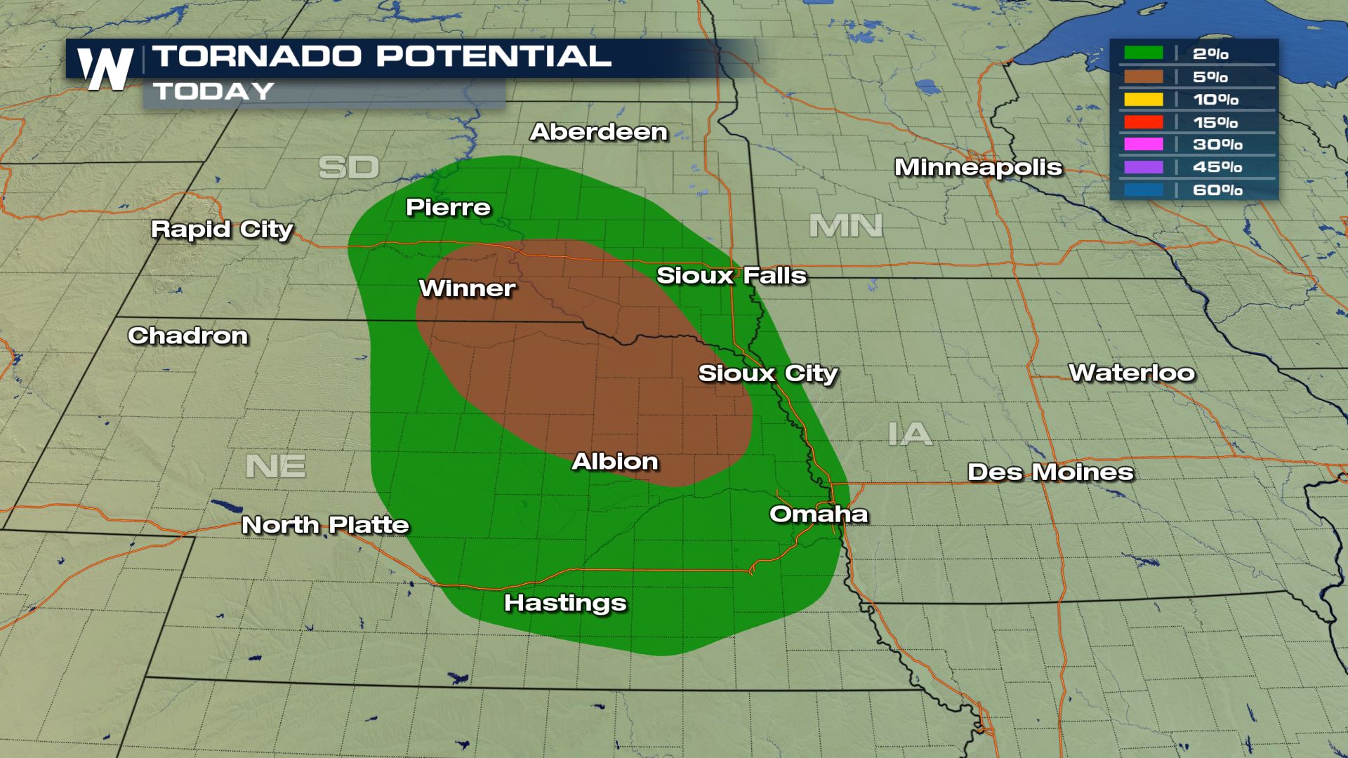 The tornado potential Wednesday, July 18
The highest potential for tornadoes will be in southeast South Dakota and eastern Nebraska.
The tornado potential Wednesday, July 18
The highest potential for tornadoes will be in southeast South Dakota and eastern Nebraska.
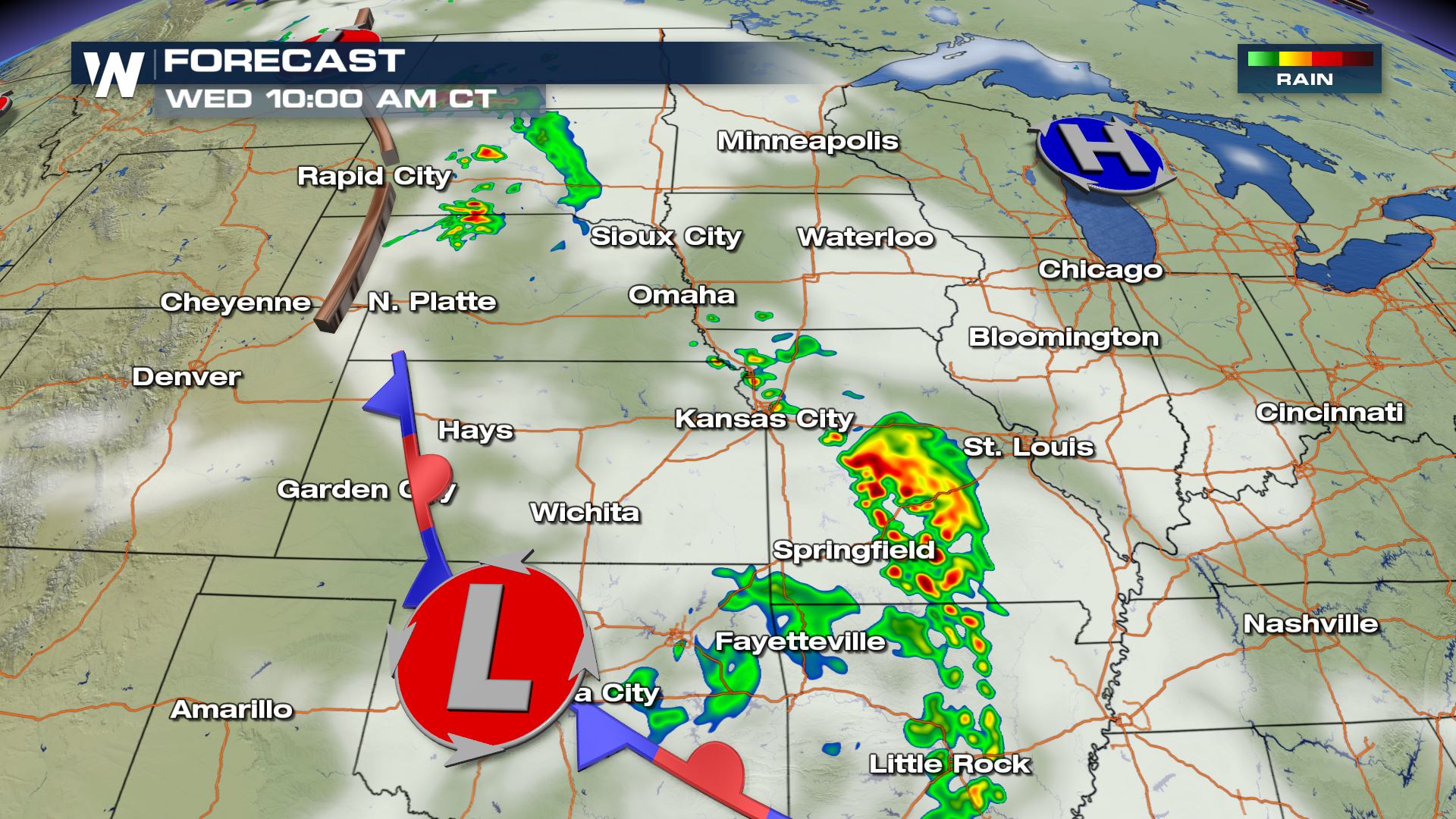 The forecast Wednesday morning, July 18 where yellows and reds show a simulation of where thunderstorms will be.
The thunderstorms will be the result of a change in air mass. Cooler, drier air across the Mississippi River Valley will be invaded by muggier, warmer air approaching from the Rockies.
The forecast Wednesday morning, July 18 where yellows and reds show a simulation of where thunderstorms will be.
The thunderstorms will be the result of a change in air mass. Cooler, drier air across the Mississippi River Valley will be invaded by muggier, warmer air approaching from the Rockies.
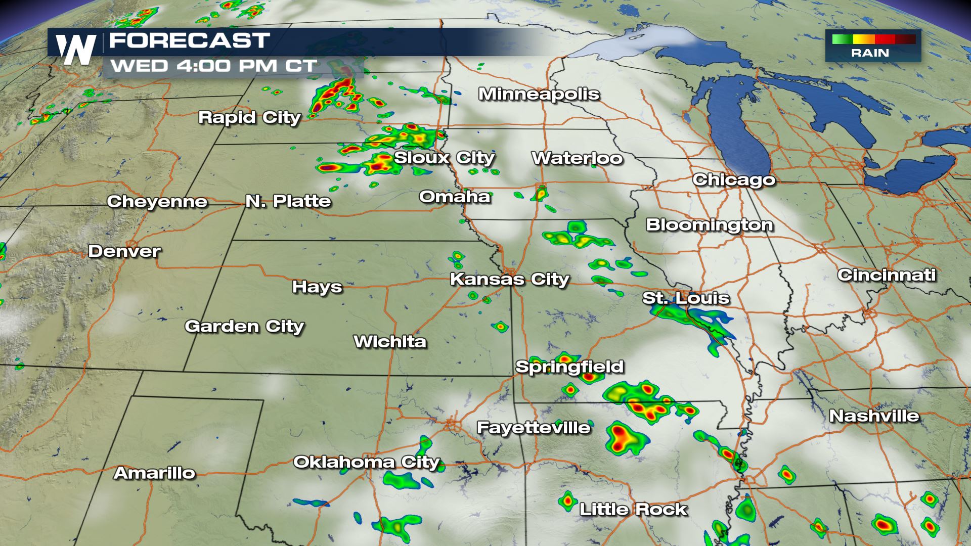 The forecast Wednesday afternoon, July 18 where yellows and reds show a simulation of where thunderstorms will be.
Thunderstorms will move to the east, parallel and most numerous between Interstates 80 (Nebraska) and 90 (South Dakota).
The forecast Wednesday afternoon, July 18 where yellows and reds show a simulation of where thunderstorms will be.
Thunderstorms will move to the east, parallel and most numerous between Interstates 80 (Nebraska) and 90 (South Dakota).
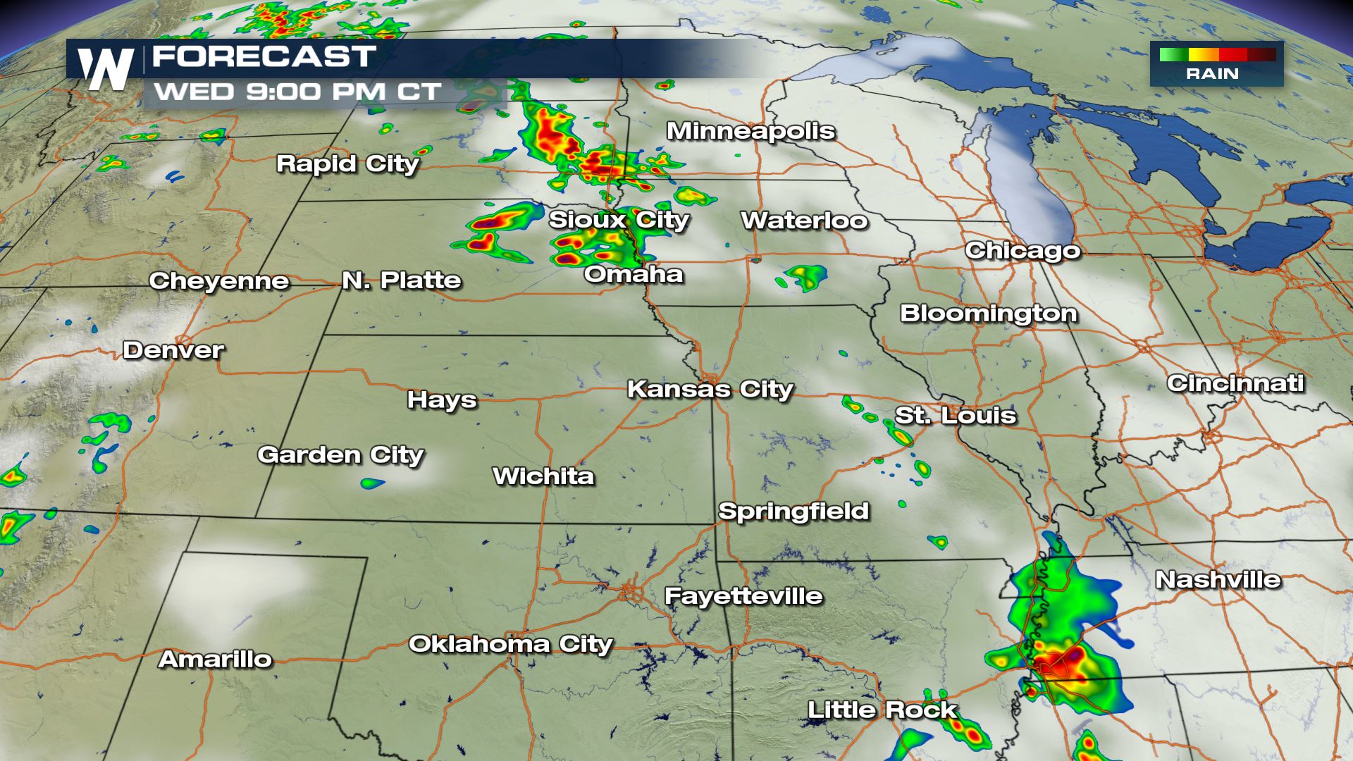 The forecast Wednesday evening, July 18 where yellows and reds show a simulation of where thunderstorms will be.
Thunderstorms will likely last beyond sunset, so have a way of getting those weather warnings!
The forecast Wednesday evening, July 18 where yellows and reds show a simulation of where thunderstorms will be.
Thunderstorms will likely last beyond sunset, so have a way of getting those weather warnings!
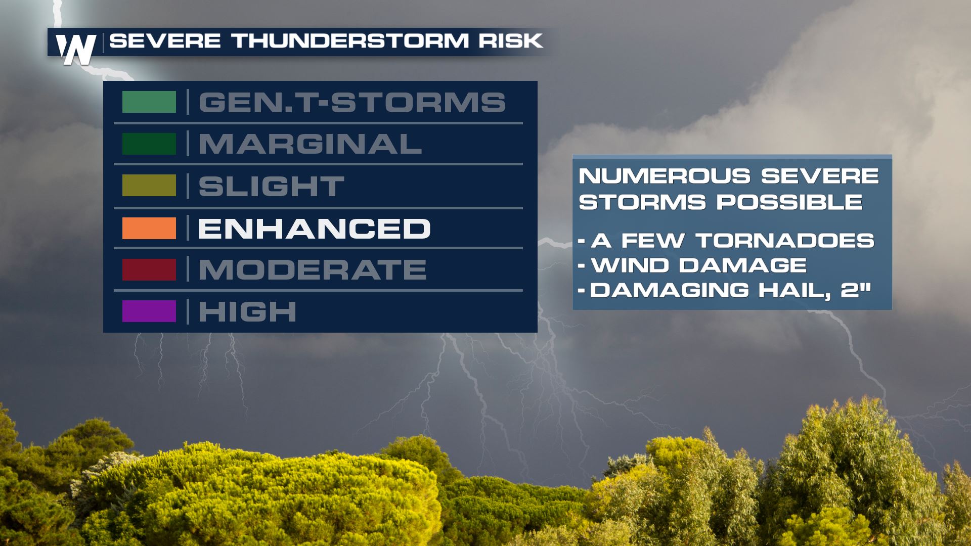 The severe thunderstorm risk is up to "Enhanced" on Wednesday meaning severe thunderstorms become more likely with a few tornadoes and hail the size of hen eggs.
We will update you throughout the day here on WeatherNationTV.com and via Facebook and Twitter.
For WeatherNation, Meteorologist Steve Glazier
The severe thunderstorm risk is up to "Enhanced" on Wednesday meaning severe thunderstorms become more likely with a few tornadoes and hail the size of hen eggs.
We will update you throughout the day here on WeatherNationTV.com and via Facebook and Twitter.
For WeatherNation, Meteorologist Steve Glazier
The severe weather outlook for Wednesday, July 18
Dark green, yellow, and orange areas will be at greatest risk of severe thunderstorms Wednesday.
The damaging wind potential on Wednesday, July 18
The greatest severe potential will be damaging wind gusts, from parts of South Dakota through Nebraska and parts of Kansas. These are the areas that may experience isolated power outages from strong winds, along with debris from the storm gusts.
The tornado potential Wednesday, July 18
The highest potential for tornadoes will be in southeast South Dakota and eastern Nebraska.
The forecast Wednesday morning, July 18 where yellows and reds show a simulation of where thunderstorms will be.
The thunderstorms will be the result of a change in air mass. Cooler, drier air across the Mississippi River Valley will be invaded by muggier, warmer air approaching from the Rockies.
The forecast Wednesday afternoon, July 18 where yellows and reds show a simulation of where thunderstorms will be.
Thunderstorms will move to the east, parallel and most numerous between Interstates 80 (Nebraska) and 90 (South Dakota).
The forecast Wednesday evening, July 18 where yellows and reds show a simulation of where thunderstorms will be.
Thunderstorms will likely last beyond sunset, so have a way of getting those weather warnings!
The severe thunderstorm risk is up to "Enhanced" on Wednesday meaning severe thunderstorms become more likely with a few tornadoes and hail the size of hen eggs.
We will update you throughout the day here on WeatherNationTV.com and via Facebook and Twitter.
For WeatherNation, Meteorologist Steve GlazierAll Weather News
More
Tropical Storm Bertha Makes Landfall Along Gulf Coast
BREAKING NEWS: Bertha made landfall within th
22 Jul 2026 7:45 PM

Another Round of Storms Targets the Northeast
Tuesday brought severe weather again across p
22 Jul 2026 7:30 PM

Flash Flooding for the Carolinas This Week
Another stalled front in the Carolinas is for
22 Jul 2026 7:20 PM

Pacific Northwest Fires Bringing Down the Air Quality
Conditions have been really dry out west. We'
22 Jul 2026 10:45 AM

Another Round of Severe Weather for the Upper Midwest and Great Lakes
The upper-level low train continues to keep t
21 Jul 2026 1:45 AM

Air Quality Improvements in the Forecast
Wildfires burning in Northwestern Ontario, Ca
20 Jul 2026 7:20 PM

Monsoon Moisture Brings Weekend Flood Threat
The monsoon has returned to the southwestern
19 Jul 2026 1:30 AM