Equipment Deployed to Study the Impact Of Burn Scars and Flash Flooding
Special Stories
17 Sep 2019 2:04 AM
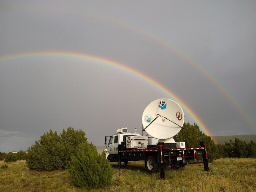
[Researchers are gathering new observations in parts of Colorado that were affected by the 2018 Spring Creek wildfire, Colorado’s third-largest wildfire which burned 108,045 acres of land. Image from NOAA]
[NOAA] To find ways to better protect people from flash floods, researchers are testing equipment and evaluating methods of observing rain and flash-flood prone areas of Colorado. Researchers from NOAA’s National Severe Storms Laboratory and the University of Oklahoma Cooperative Institute for Mesoscale Meteorological Studies are utilizing a suite of tools, including NSSL’s mobile Doppler radar in an effort to gather new observations on rain. From June through September, researchers are gathering new observations in parts of Colorado that were affected by the 2018 Spring Creek wildfire, Colorado’s third-largest wildfire which burned 108,045 acres of land.
“Federal and state partners have teamed up to provide, for the first time, a very dense observational network on the Spring Creek burn scar in Colorado,” said Jonathan Gourley, an NSSL Researcher. “In addition to the deployment of NSSL’s mobile radar, the experimental network is comprised of rain gauges, stream radars, surface velocity measurements, and soil moisture sensors, all positioned within the burn scar.”
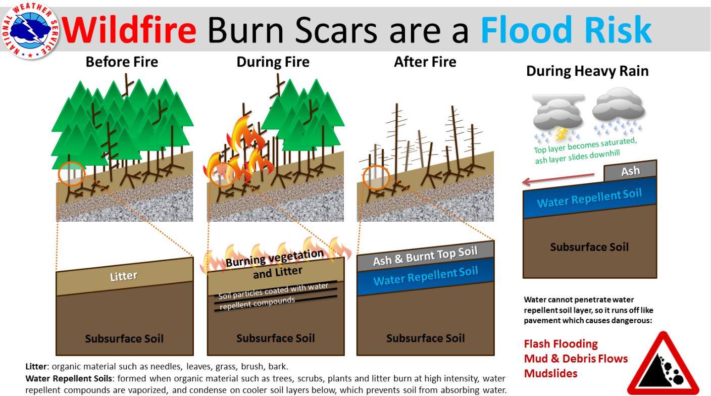
The scientists chose these locations because areas that are burned by wildfires are more susceptible to flash flooding and debris flows, as burned soil tends to repel, rather than absorb, water. Researchers want to demonstrate the value of observations gathered by this equipment to develop early alerts of flash flooding and debris flows on burn scars.
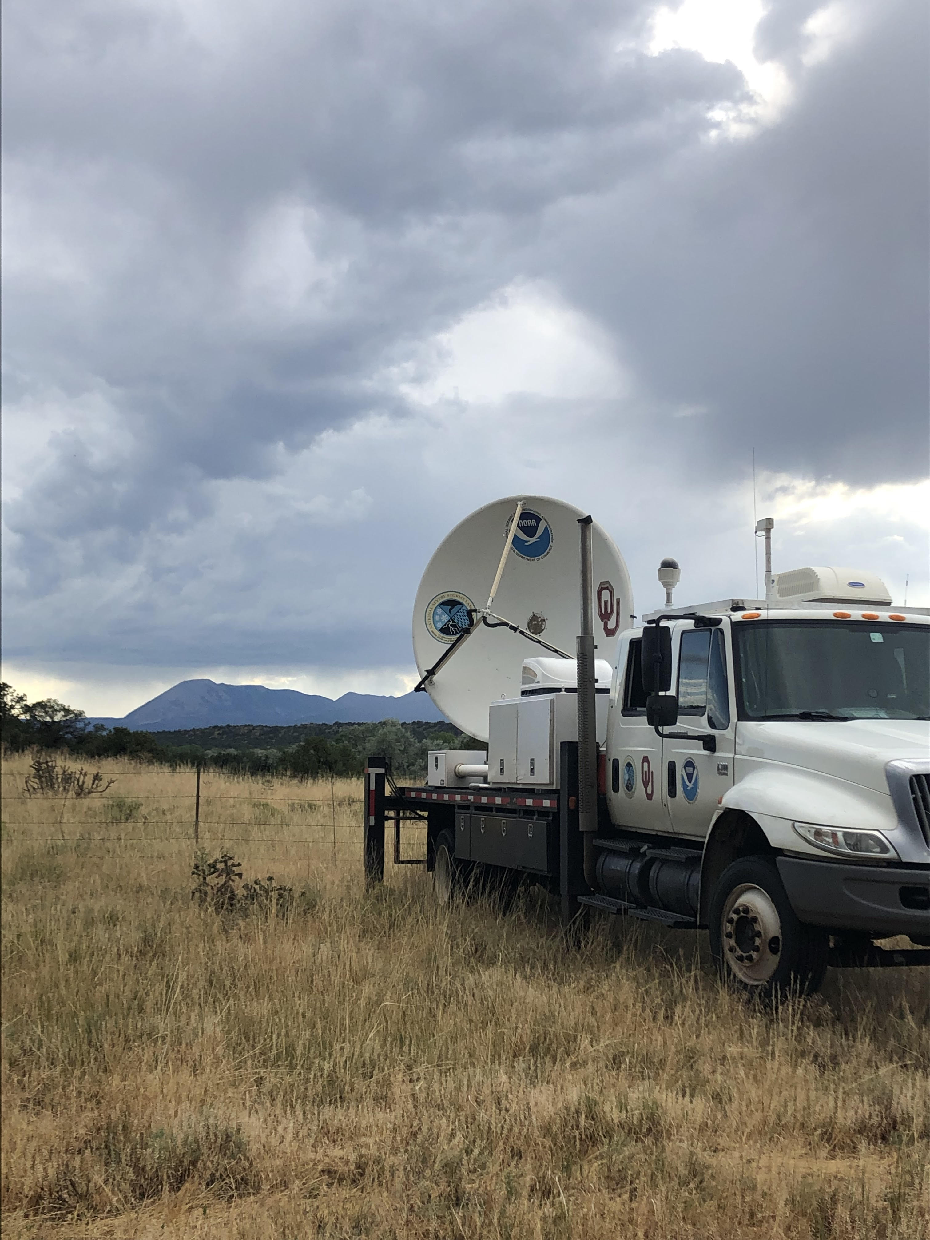 [NSSL’s mobile radar in Colorado near a burn scar. Image from NOAA]
“Burn scars are prolific at producing flash floods,” Gourley said. “The loss of vegetation and changes to the soil structure enhances the amount and velocity of runoff for a given rainfall event. Despite their devastating impacts, we have limited knowledge about the transition of rainfall-to-runoff and the tools used to forecast flash flooding on burn scars.”
The mobile radar is deployed less than 20 miles from the burn area. Researchers are using the mobile radar to monitor the lower atmosphere and supplement current NEXRAD radar coverage. The terrain in mountainous areas, like Colorado, causes difficulties for NEXRAD radars. The radar beam cannot “see” storms as it can in flatter areas, like the plains. NSSL’s mobile radar supplements NEXRAD coverage by providing more information near the ground and providing higher-resolution data for forecasters during intense rainfall events near the burn scar.
“These observations will transform our understanding and forecasting tools, which are becoming increasingly important given the expanding areas, durations, and intensities with wildfires,” Gourley said. So far, the observations have been promising. In July, a major storm near La Veta brought more than 1.5 inches of rain per hour and local officials provided eight reports of flash flooding. One creek overflowed by two feet and was more than 100-yards wide. Researchers collaborated with National Weather Service forecasters to provide more products and information for increased warning time.
[NSSL’s mobile radar in Colorado near a burn scar. Image from NOAA]
“Burn scars are prolific at producing flash floods,” Gourley said. “The loss of vegetation and changes to the soil structure enhances the amount and velocity of runoff for a given rainfall event. Despite their devastating impacts, we have limited knowledge about the transition of rainfall-to-runoff and the tools used to forecast flash flooding on burn scars.”
The mobile radar is deployed less than 20 miles from the burn area. Researchers are using the mobile radar to monitor the lower atmosphere and supplement current NEXRAD radar coverage. The terrain in mountainous areas, like Colorado, causes difficulties for NEXRAD radars. The radar beam cannot “see” storms as it can in flatter areas, like the plains. NSSL’s mobile radar supplements NEXRAD coverage by providing more information near the ground and providing higher-resolution data for forecasters during intense rainfall events near the burn scar.
“These observations will transform our understanding and forecasting tools, which are becoming increasingly important given the expanding areas, durations, and intensities with wildfires,” Gourley said. So far, the observations have been promising. In July, a major storm near La Veta brought more than 1.5 inches of rain per hour and local officials provided eight reports of flash flooding. One creek overflowed by two feet and was more than 100-yards wide. Researchers collaborated with National Weather Service forecasters to provide more products and information for increased warning time.
 Researchers are also testing a product that computes rainfall accumulations at 15, 30 and 60-minute time periods and compares those accumulations to United States Geological Survey-derived debris flow thresholds for the same time period. It is one of many products developed and utilized by researchers to study flooding and debris flow in areas ravaged by wildfires.
Known as the “Wildfire Rain” product, this algorithm utilizes short-term rainfall estimation techniques to provide forecasts of how fast rain may fall and whether it is anticipated to cause flash flooding and debris flows on the burn scars. This experimental tool is used by three local NWS Colorado forecast offices and allows a longer lead time for flash flooding events.
In addition to the Wildfire Rain product, this summer researchers deployed a network of rain gauges, soil moisture sensors and stream radars in Colorado. The stream radars use remote sensing to measure the speed, depth, and flow rates in streams. These products provide on-the-ground validation of flooding at points of interest like bridges and roadways. Monitoring efforts will continue through 2020 as researchers continue to develop ways to monitor and warn for flash flooding and debris flow.
Edited for WeatherNation by Meteorologist Mace Michaels
Researchers are also testing a product that computes rainfall accumulations at 15, 30 and 60-minute time periods and compares those accumulations to United States Geological Survey-derived debris flow thresholds for the same time period. It is one of many products developed and utilized by researchers to study flooding and debris flow in areas ravaged by wildfires.
Known as the “Wildfire Rain” product, this algorithm utilizes short-term rainfall estimation techniques to provide forecasts of how fast rain may fall and whether it is anticipated to cause flash flooding and debris flows on the burn scars. This experimental tool is used by three local NWS Colorado forecast offices and allows a longer lead time for flash flooding events.
In addition to the Wildfire Rain product, this summer researchers deployed a network of rain gauges, soil moisture sensors and stream radars in Colorado. The stream radars use remote sensing to measure the speed, depth, and flow rates in streams. These products provide on-the-ground validation of flooding at points of interest like bridges and roadways. Monitoring efforts will continue through 2020 as researchers continue to develop ways to monitor and warn for flash flooding and debris flow.
Edited for WeatherNation by Meteorologist Mace Michaels
[NSSL’s mobile radar in Colorado near a burn scar. Image from NOAA]
“Burn scars are prolific at producing flash floods,” Gourley said. “The loss of vegetation and changes to the soil structure enhances the amount and velocity of runoff for a given rainfall event. Despite their devastating impacts, we have limited knowledge about the transition of rainfall-to-runoff and the tools used to forecast flash flooding on burn scars.”
The mobile radar is deployed less than 20 miles from the burn area. Researchers are using the mobile radar to monitor the lower atmosphere and supplement current NEXRAD radar coverage. The terrain in mountainous areas, like Colorado, causes difficulties for NEXRAD radars. The radar beam cannot “see” storms as it can in flatter areas, like the plains. NSSL’s mobile radar supplements NEXRAD coverage by providing more information near the ground and providing higher-resolution data for forecasters during intense rainfall events near the burn scar.
“These observations will transform our understanding and forecasting tools, which are becoming increasingly important given the expanding areas, durations, and intensities with wildfires,” Gourley said. So far, the observations have been promising. In July, a major storm near La Veta brought more than 1.5 inches of rain per hour and local officials provided eight reports of flash flooding. One creek overflowed by two feet and was more than 100-yards wide. Researchers collaborated with National Weather Service forecasters to provide more products and information for increased warning time.
Researchers are also testing a product that computes rainfall accumulations at 15, 30 and 60-minute time periods and compares those accumulations to United States Geological Survey-derived debris flow thresholds for the same time period. It is one of many products developed and utilized by researchers to study flooding and debris flow in areas ravaged by wildfires.
Known as the “Wildfire Rain” product, this algorithm utilizes short-term rainfall estimation techniques to provide forecasts of how fast rain may fall and whether it is anticipated to cause flash flooding and debris flows on the burn scars. This experimental tool is used by three local NWS Colorado forecast offices and allows a longer lead time for flash flooding events.
In addition to the Wildfire Rain product, this summer researchers deployed a network of rain gauges, soil moisture sensors and stream radars in Colorado. The stream radars use remote sensing to measure the speed, depth, and flow rates in streams. These products provide on-the-ground validation of flooding at points of interest like bridges and roadways. Monitoring efforts will continue through 2020 as researchers continue to develop ways to monitor and warn for flash flooding and debris flow.
Edited for WeatherNation by Meteorologist Mace MichaelsAll Weather News
More
Severe Storms Target the Midwest to the Northeast This Week
Extreme heat will be a big story this week ac
27 Jul 2026 2:25 PM

Tropics: Fausto Heads towards Hawaii; Genevieve Cat 5 Hurricane
Atlantic BasinBertha has dissipated after mov
27 Jul 2026 2:20 PM


Southeast Flood Risk Lingers Near Stalled Front
A stalled boundary over the Southeast will ke
25 Jul 2026 10:55 AM

Another Round of Storms Targets the Northeast
Tuesday brought severe weather again across p
23 Jul 2026 1:15 AM

Another Round of Severe Weather for the Upper Midwest and Great Lakes
The upper-level low train continues to keep t
21 Jul 2026 1:45 AM