Exceptionally Large Amount of Snow in Northern Hemisphere This Year
Special Stories
16 Mar 2018 9:08 AM
From Finish Meteorological Institute
After several Nor'easters hitting the nation, it probably wouldn't surprise most folks (especially those of you in the Northeast) that there is a lot of snow on the ground. The U.S. is not the only place - much of the Northern Hemisphere is seeing extensive snow cover this year. The new "Arctic Now" product developed by the Finnish Meteorological Institute shows with one picture the extent of the area in the Northern Hemisphere currently covered by ice and snow.
In the Northern Hemisphere, the maximum seasonal snow cover occurs in March. "This year has been a year with an exceptionally large amount of snow, when examining the entire Northern Hemisphere. The variation from one year to another has been somewhat great, and especially in the most recent years the differences between winters have been very great", says Kari Luojus, Senior Research Scientist at the Finnish Meteorological Institute.
The information has been gleaned from the "Arctic Now" service of the Finnish Meteorological Institute, which is unique even on a global scale. The greatest difference compared with other comparable services is that traditionally they only tell about the extent of the ice or snow situation.
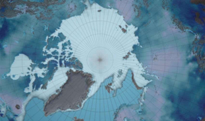
 [Arctic now loop of snow coverage from February 15th to March 15. From Finnish Meteorological Institute]
"Here at the Finnish Meteorological Institute we have managed to combine data to form a single image. In this way we can get a better situational picture of the cryosphere - that is, the cold areas of the Northern Hemisphere", Research Professor Jouni Pulliainen observes. In addition to the coverage, the picture includes the water value of the snow, which determines the water contained in the snow. This is important information for drafting hydrological forecasts on the flood situation and in monitoring the state of the environment in general.
[Arctic now loop of snow coverage from February 15th to March 15. From Finnish Meteorological Institute]
"Here at the Finnish Meteorological Institute we have managed to combine data to form a single image. In this way we can get a better situational picture of the cryosphere - that is, the cold areas of the Northern Hemisphere", Research Professor Jouni Pulliainen observes. In addition to the coverage, the picture includes the water value of the snow, which determines the water contained in the snow. This is important information for drafting hydrological forecasts on the flood situation and in monitoring the state of the environment in general.
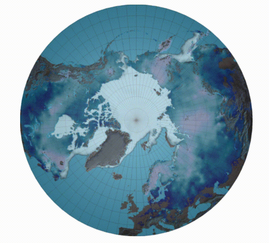
 [Average ice coverage from 2006-2015. From Washington Post]
[Arctic now loop of snow coverage from February 15th to March 15. From Finnish Meteorological Institute]
"Here at the Finnish Meteorological Institute we have managed to combine data to form a single image. In this way we can get a better situational picture of the cryosphere - that is, the cold areas of the Northern Hemisphere", Research Professor Jouni Pulliainen observes. In addition to the coverage, the picture includes the water value of the snow, which determines the water contained in the snow. This is important information for drafting hydrological forecasts on the flood situation and in monitoring the state of the environment in general.
Total amount of snow declines and snow starts to melt earlier
Information on the amount of snow is also sent to the Global Cryosphere Watch service of the World Meteorological Organisation (WMO) where the information is combined with trends and statistics of past years. Lengthy series of observation times show that the total amount of snow in the Northern Hemisphere has declined in the spring period and that the melting of the snow has started earlier in the same period. Examination over a longer period (1980-2017) shows that the total amount of snow in all winter periods has decreased on average. Also, the ice cover on the Arctic Ocean has grown thinner, and the amount and expanse of perennial ice has decreased. Before year 2000, the smallest expanse of sea ice varied between 3.9 and 4.9 million square miles. In the past 10 years, the expanse of ice has varied from 3.3 to 2.2 million square miles.
[Average ice coverage from 2006-2015. From Washington Post]
When it was freezing cold, it can be exceptionally warm at the North Pole
"What happens in the Arctic regions does not stay in the Arctic regions, and a wider area is affected. When it is exceptionally cold somewhere in the world, it is often exceptionally warm somewhere else. This is what happened in the end of February-early March when temperatures in the North Pole were around zero degrees Celsius and it was exceptionally cold in Europe", explains Ari Laaksonen, Scientific Director at the Finnish Meteorological Institute. Edited for WeatherNation by Meteorologist Mace MichaelsAll Weather News
More


More Storms for the East Sunday and Monday
A low-pressure system crashing through the Mi
2 Aug 2026 2:20 AM

After Reaching Category 5, Genevieve Weakens in the Pacific
PacificGenevieve formed on last Friday south
2 Aug 2026 1:30 AM

Flooding, Severe Storms Target the Midwest Again
After an active week of storms across the nor
1 Aug 2026 1:40 AM

Flooding Risk Increases as Heavy Rain Targets the Tri-State Area
Tuesday, heavy rainfall moved across the Nort
30 Jul 2026 12:25 AM

Severe Weather: Energy From the Midwest Now in the Southeast
UPPER MIDWEST - Through Monday, dangerous tor
29 Jul 2026 10:30 PM