Explaining Santa Ana Winds

Top Stories
22 Dec 2020 1:01 PM
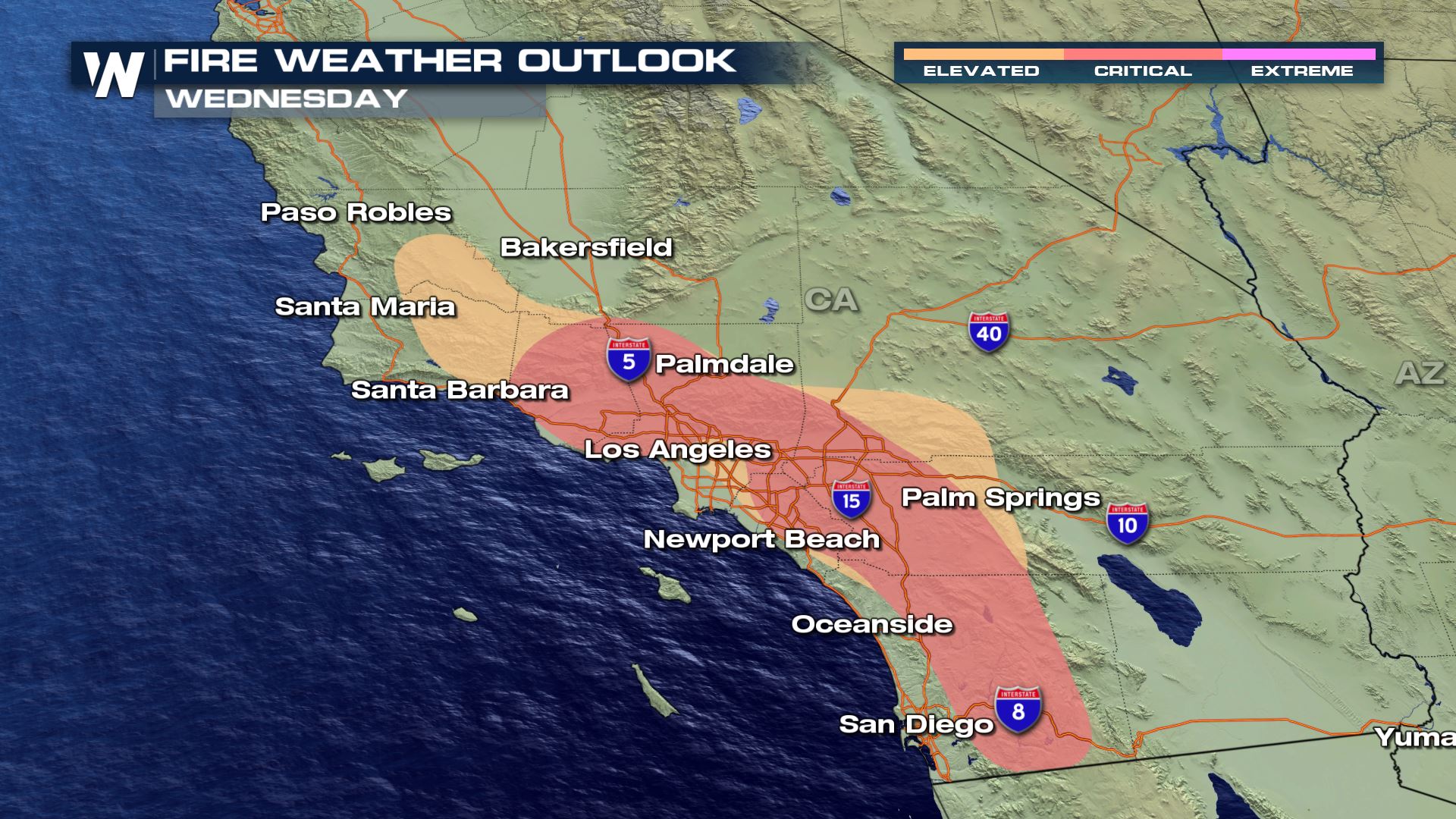
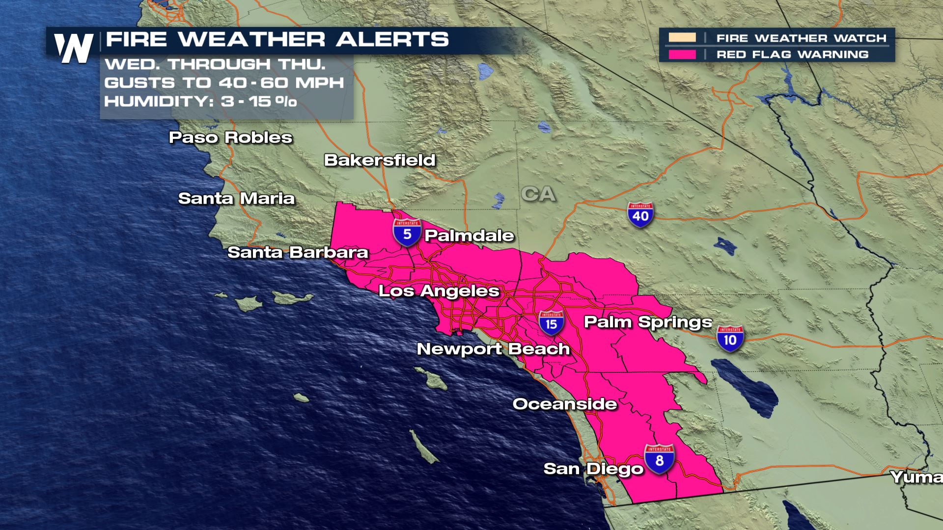
Santa Ana winds are one of Southern California’s most recognized weather features, especially from the fall to the spring. This week, they will elevate fire danger from San Luis Obispo County to Los Angeles from Wednesday through Thursday.
 "It’s one of the most impactful patterns we can have in Southern California," said Mark Jackson, Meteorologist in Charge at the National Weather Service in Los Angeles, CA. "Everybody hears about the wildfires in Southern California and the driving force behind that are these Santa Ana winds."
These are northeasterly, offshore winds that descend in elevation and can sometimes reach hurricane-force strength.
"When you get the very hot, the very dry conditions combined with very strong winds, we can have some Santa Anas that have winds gusting over 100 mph," Jackson said.
These winds originate from high pressure over the Great Basin with low pressure off the coast. Winds flow from high pressure to low pressure, and the stronger the gradient (or pressure difference between the two), the stronger those winds can be. As the winds get closer to sea level, they speed up, dry out, and heat the air.
"It can actually warm on a rate of almost 30 degrees Fahrenheit per mile!" Jackson said.
https://twitter.com/NWSLosAngeles/status/1341162743399739392?s=20
The combination of hot, dry and windy contributes to a number of changes to the weather including record setting temperatures and, most notably, dangerous fire weather conditions.
"I would say that our strongest Santa Anas are probably in the early morning hours so just before sunrise and just after sunrise," Jackson said. "When you have a better chance at getting very hot temperatures, that can naturally bring that relative humidity even lower in the afternoon."
https://twitter.com/i/status/938445393213325312
Santa Anas last around the clock and sometimes days in a row, with little to no relief. Fortunately, forecasters are able to spot this pattern up to 6 to 7 days in advance.
"We may not have the exact time of when that may peak between a certain 6 or 12 hour period, but we can provide the fire agencies information with the idea that say a week from now things are setting up that we could have a pretty strong Santa Ana," Jackson said.
https://youtu.be/m2KmX5Vj2Jc
"It’s one of the most impactful patterns we can have in Southern California," said Mark Jackson, Meteorologist in Charge at the National Weather Service in Los Angeles, CA. "Everybody hears about the wildfires in Southern California and the driving force behind that are these Santa Ana winds."
These are northeasterly, offshore winds that descend in elevation and can sometimes reach hurricane-force strength.
"When you get the very hot, the very dry conditions combined with very strong winds, we can have some Santa Anas that have winds gusting over 100 mph," Jackson said.
These winds originate from high pressure over the Great Basin with low pressure off the coast. Winds flow from high pressure to low pressure, and the stronger the gradient (or pressure difference between the two), the stronger those winds can be. As the winds get closer to sea level, they speed up, dry out, and heat the air.
"It can actually warm on a rate of almost 30 degrees Fahrenheit per mile!" Jackson said.
https://twitter.com/NWSLosAngeles/status/1341162743399739392?s=20
The combination of hot, dry and windy contributes to a number of changes to the weather including record setting temperatures and, most notably, dangerous fire weather conditions.
"I would say that our strongest Santa Anas are probably in the early morning hours so just before sunrise and just after sunrise," Jackson said. "When you have a better chance at getting very hot temperatures, that can naturally bring that relative humidity even lower in the afternoon."
https://twitter.com/i/status/938445393213325312
Santa Anas last around the clock and sometimes days in a row, with little to no relief. Fortunately, forecasters are able to spot this pattern up to 6 to 7 days in advance.
"We may not have the exact time of when that may peak between a certain 6 or 12 hour period, but we can provide the fire agencies information with the idea that say a week from now things are setting up that we could have a pretty strong Santa Ana," Jackson said.
https://youtu.be/m2KmX5Vj2JcAll Weather News
More
Fronts Continue To Spark Severe Weather Across the Plains
A cold front that brought record lows to the
18 Jul 2025 10:40 PM

Extreme Heat Impacts for the East Coast & South
Extreme heat continues to impact several area
18 Jul 2025 10:05 PM

Flooding Threat Remains Elevated in the East
A cold front pushing through the Eastern Seab
18 Jul 2025 9:10 PM

EF-2 Firenado from the Deer Creek Fire in Utah
A fire tornado was spotted near La Sal, Utah
18 Jul 2025 7:30 AM

Tropical System Brings Flood Risk to the Central Gulf
Time has run out for notable tropical develop
18 Jul 2025 3:05 AM

Heavy Rain, Flooding Threat Returns to Florida
Keep the rain boots handy in Florida - heavy
13 Jul 2025 12:50 PM

Severe Storm Risk Pushes into the Great Lakes, Ohio Valley
Friday was another busy day with severe weath
12 Jul 2025 8:00 PM