February 2020 Weather and Climate Stats
Special Stories
10 Mar 2020 1:37 AM
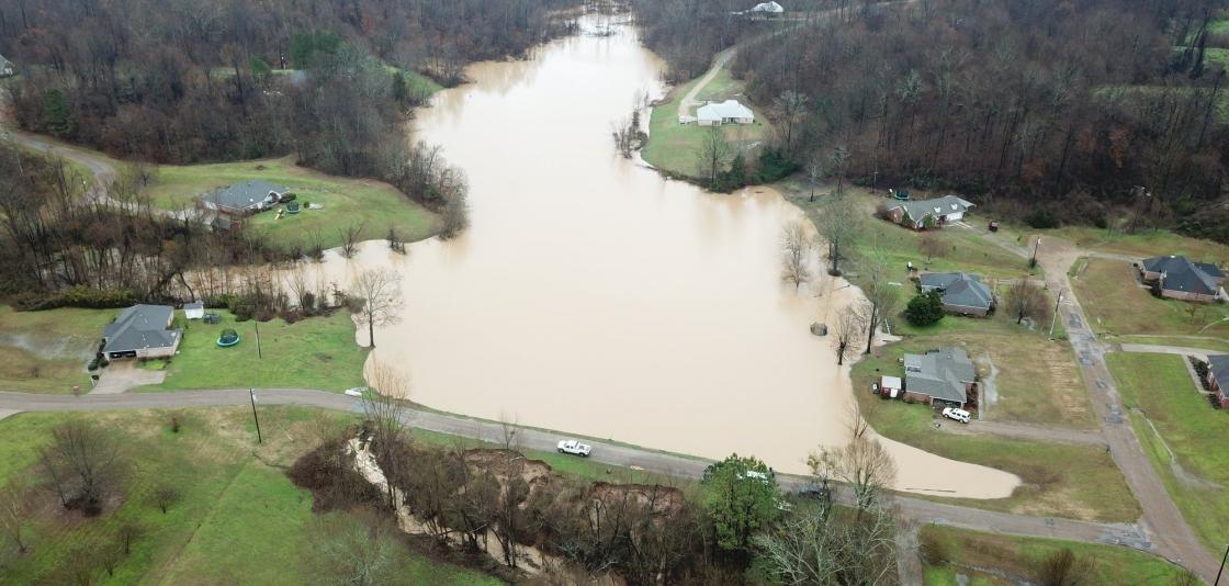
[February 11, 2020 -- An aerial photo of a levee failure that flooded the Springridge Place Subdivision in Yazoo County, Mississippi, following heavy rainfall. Four homes and a church were threatened. From MS Emergency Management Agency via Facebook]
The numbers have been crunched and the climate statistics are in from February. Here's a look back at the month. Information written from the National Centers for Environmental Information, NOAA, and Rebecca Lindsey at NOAA Climate.
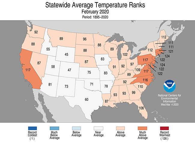
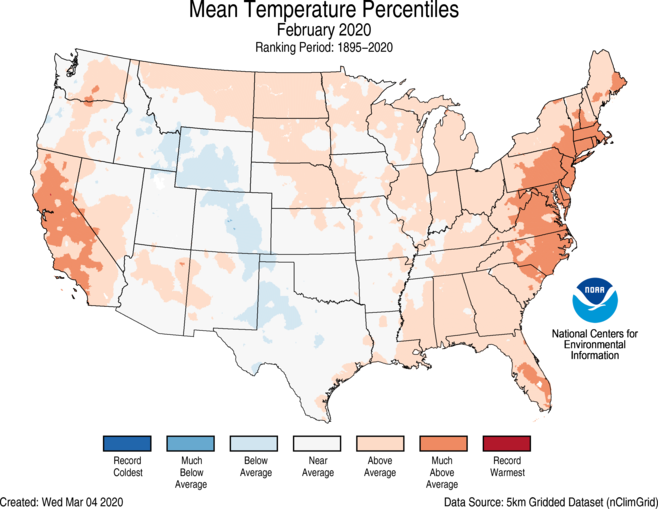 The average February temperature across the contiguous U.S. was 36.2 degrees F (2.4 degrees above the 20th-century average), which ranked in the warmest third of the 126-year record.
Much-above-average temperatures were felt across parts of the Mid-Atlantic and Northeast, as well as portions of California and Florida. New Jersey and Rhode Island ranked third warmest, while Maryland, Delaware and Connecticut ranked fifth warmest.
Below-average temperatures were observed across portions of the central Rockies to western Texas during February, but no state ranked below average for the month.
The average February temperature across the contiguous U.S. was 36.2 degrees F (2.4 degrees above the 20th-century average), which ranked in the warmest third of the 126-year record.
Much-above-average temperatures were felt across parts of the Mid-Atlantic and Northeast, as well as portions of California and Florida. New Jersey and Rhode Island ranked third warmest, while Maryland, Delaware and Connecticut ranked fifth warmest.
Below-average temperatures were observed across portions of the central Rockies to western Texas during February, but no state ranked below average for the month.
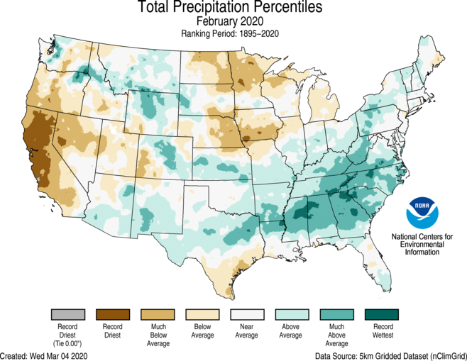 Among the highlights of the February 2020 climate summary for the United States were the precipitation extremes experienced by different parts of the country. Much of the Southeast experienced record or near-record wet conditions last month, while almost all of California and parts of Oregon and Nevada were either much drier than average or record dry. Stations across the San Francisco Bay area and interior parts of northern California tied or set records for driest February on record. San Francisco, San Jose, Sacramento, Oakland and many other stations received no precipitation during the month, setting local records for the driest February.
 The February numbers brought no good news for California, which depends on winter months for the lion’s share of its annual precipitation. On the heels of a drier-than-average January, February was drier still, with many areas reporting less than 5% of their normal rainfall. Some locations in the northern part of the state received no measurable precipitation all month, setting local records for the driest February and bringing an early start to the annual fire season.
At the other extreme, an continuous arc of record to near-record wet conditions stretched from eastern Texas through the Southeast and up the Southern Appalachians to West Virginia. Among other impacts, heavy rain caused landslides in Virginia, historic flooding in Mississippi, and road closures in Alabama.
Georgia ranked second wettest, while Alabama and North Carolina ranked third wettest on record.
The February numbers brought no good news for California, which depends on winter months for the lion’s share of its annual precipitation. On the heels of a drier-than-average January, February was drier still, with many areas reporting less than 5% of their normal rainfall. Some locations in the northern part of the state received no measurable precipitation all month, setting local records for the driest February and bringing an early start to the annual fire season.
At the other extreme, an continuous arc of record to near-record wet conditions stretched from eastern Texas through the Southeast and up the Southern Appalachians to West Virginia. Among other impacts, heavy rain caused landslides in Virginia, historic flooding in Mississippi, and road closures in Alabama.
Georgia ranked second wettest, while Alabama and North Carolina ranked third wettest on record.
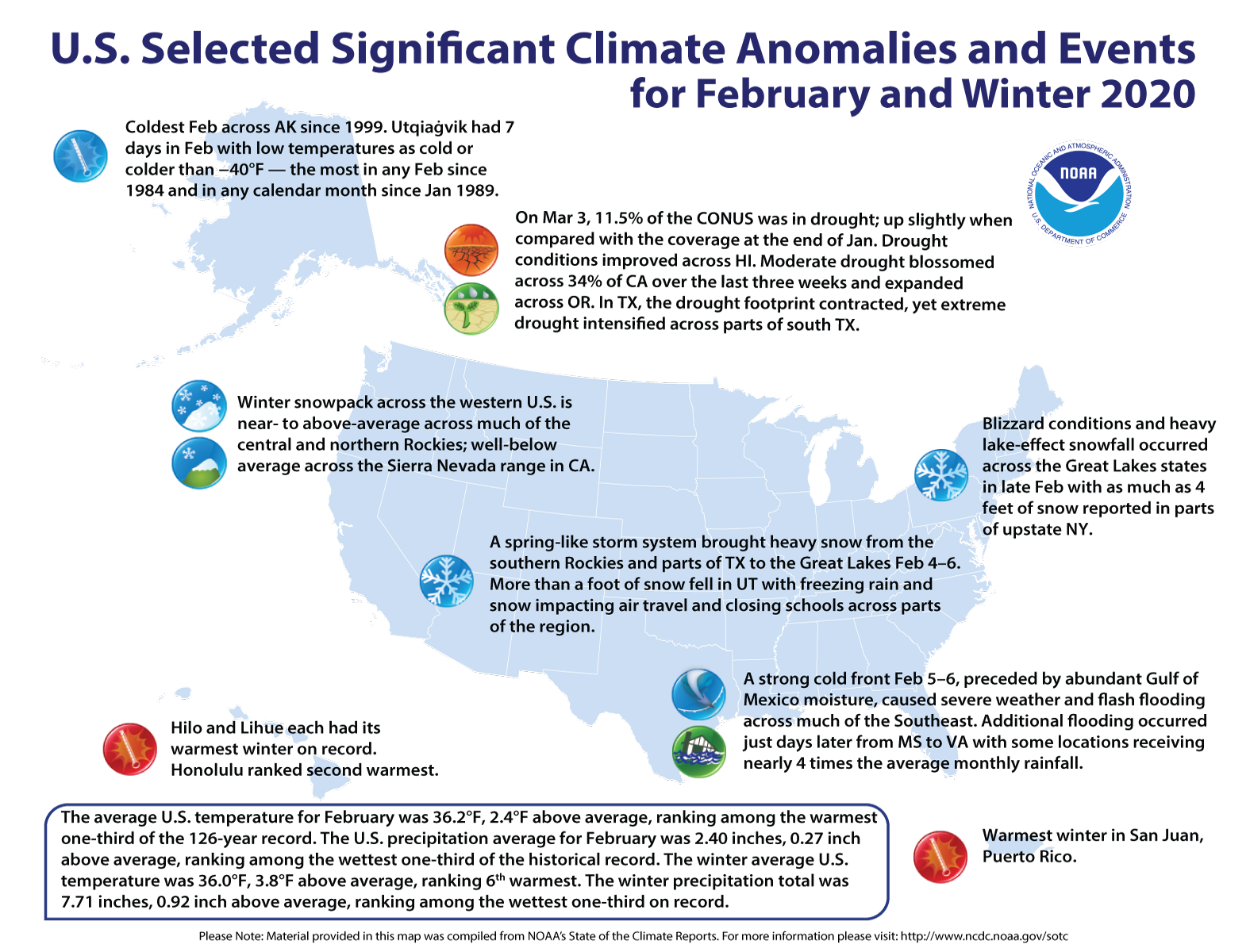 Alaska on ice: The Alaska February temperature was 1.5°F, 3.3°F below the long-term average. This ranked among the coldest one-third of the 96-year period of record for the state and was the coldest February since 1999. It was the coldest February since 1984 in Utqiaġvik (Barrow). Utqiaġvik had seven days in February with low temperatures as cold or colder than −40°F — the most in any February since 1984 and in any calendar month since January 1989. For the first time in 21 years, Fairbanks remained below freezing during all of meteorological winter.
California eyes its water supply: After a very dry January, California had a record-dry February with only 0.20 of an inch of precipitation, beating the previous record of 0.31 inch in 1964. The arid winter increased concerns for sufficient water to get through the summer, as well as to fight wildfires that commonly occur in the fall.
Alaska on ice: The Alaska February temperature was 1.5°F, 3.3°F below the long-term average. This ranked among the coldest one-third of the 96-year period of record for the state and was the coldest February since 1999. It was the coldest February since 1984 in Utqiaġvik (Barrow). Utqiaġvik had seven days in February with low temperatures as cold or colder than −40°F — the most in any February since 1984 and in any calendar month since January 1989. For the first time in 21 years, Fairbanks remained below freezing during all of meteorological winter.
California eyes its water supply: After a very dry January, California had a record-dry February with only 0.20 of an inch of precipitation, beating the previous record of 0.31 inch in 1964. The arid winter increased concerns for sufficient water to get through the summer, as well as to fight wildfires that commonly occur in the fall.
TEMPERATURE
The average February temperature across the contiguous U.S. was 36.2 degrees F (2.4 degrees above the 20th-century average), which ranked in the warmest third of the 126-year record.
Much-above-average temperatures were felt across parts of the Mid-Atlantic and Northeast, as well as portions of California and Florida. New Jersey and Rhode Island ranked third warmest, while Maryland, Delaware and Connecticut ranked fifth warmest.
Below-average temperatures were observed across portions of the central Rockies to western Texas during February, but no state ranked below average for the month.
PRECIPITATION
Among the highlights of the February 2020 climate summary for the United States were the precipitation extremes experienced by different parts of the country. Much of the Southeast experienced record or near-record wet conditions last month, while almost all of California and parts of Oregon and Nevada were either much drier than average or record dry. Stations across the San Francisco Bay area and interior parts of northern California tied or set records for driest February on record. San Francisco, San Jose, Sacramento, Oakland and many other stations received no precipitation during the month, setting local records for the driest February.
Last month’s average precipitation was 2.40 inches (0.27 of an inch above average), ranking in the wettest third of the historical record.
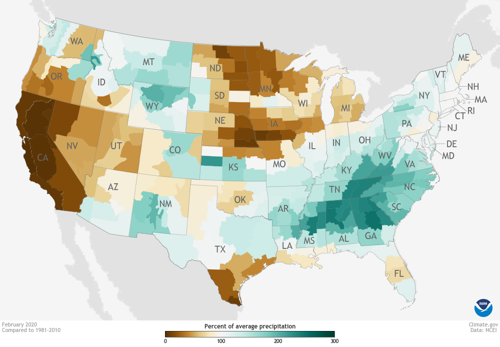
This map shows precipitation—including both rain and snow—for February 2020 as a percent of the 1981-2020 average. Places where precipitation was close to 100% of average are white or very light yellow (just barely below normal) or very light green (just barely above normal). Dark browns and greens indicate extreme departures from average.
The February numbers brought no good news for California, which depends on winter months for the lion’s share of its annual precipitation. On the heels of a drier-than-average January, February was drier still, with many areas reporting less than 5% of their normal rainfall. Some locations in the northern part of the state received no measurable precipitation all month, setting local records for the driest February and bringing an early start to the annual fire season.
At the other extreme, an continuous arc of record to near-record wet conditions stretched from eastern Texas through the Southeast and up the Southern Appalachians to West Virginia. Among other impacts, heavy rain caused landslides in Virginia, historic flooding in Mississippi, and road closures in Alabama.
Georgia ranked second wettest, while Alabama and North Carolina ranked third wettest on record.
OTHER NOTABLE CLIMATE EVENTS
Alaska on ice: The Alaska February temperature was 1.5°F, 3.3°F below the long-term average. This ranked among the coldest one-third of the 96-year period of record for the state and was the coldest February since 1999. It was the coldest February since 1984 in Utqiaġvik (Barrow). Utqiaġvik had seven days in February with low temperatures as cold or colder than −40°F — the most in any February since 1984 and in any calendar month since January 1989. For the first time in 21 years, Fairbanks remained below freezing during all of meteorological winter.
California eyes its water supply: After a very dry January, California had a record-dry February with only 0.20 of an inch of precipitation, beating the previous record of 0.31 inch in 1964. The arid winter increased concerns for sufficient water to get through the summer, as well as to fight wildfires that commonly occur in the fall.All Weather News
More
Wildfire Outbreak in the Pacific Northwest
SPOKANE, WA - On Saturday, August 1st, the Ol
3 Aug 2026 1:55 AM

More Storms for the East Through Monday
A low-pressure system that moved through the
3 Aug 2026 1:50 AM


After Reaching Category 5, Genevieve Weakens in the Pacific
PacificGenevieve formed last Friday south of
3 Aug 2026 12:30 AM

Flooding, Severe Storms Target the Midwest Again
After an active week of storms across the nor
1 Aug 2026 1:40 AM

Flooding Risk Increases as Heavy Rain Targets the Tri-State Area
Tuesday, heavy rainfall moved across the Nort
30 Jul 2026 12:25 AM

Severe Weather: Energy From the Midwest Now in the Southeast
UPPER MIDWEST - Through Monday, dangerous tor
29 Jul 2026 10:30 PM