Fingers Crossed: Atlantic Tropics Remain Quiet

Top Stories
22 Jul 2018 1:55 PM
As we move into the fourth week of July, there's good news in the tropics: No news.
The Atlantic remains quiet, with no storms since Tropical Storm Beryl dissipated earlier this month. The National Hurricane Center (NHC) is not anticipating any storm development in the next five days, meaning the short-term outlook is calm.
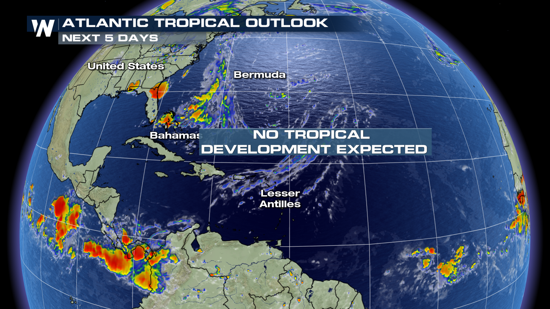 Two general factors are keeping the Atlantic's tropics relatively calm, at least for now: One, and most importantly, strong trade winds are suppressing storms from growing, due to essentially 'tearing apart' storms before they can fully form. Two, cooler-than-average water temperatures between the Lesser Antilles island chain and the west coast of Africa (covering most of the central Atlantic) are running below average, giving possible storms less energy to work with.
That said, deep tropical moisture is blasting much of the East Coast with continued heavy rainfall. Washington, D.C. saw its wettest day in almost eight years on Saturday (4.00"), and the I-95 corridor will be looking at a very soggy start to the week thanks to a stalled low.
But in terms of Atlantic tropical storms or hurricanes, things for now are quiet, fortunately. The climatological peak of hurricane season is in early-to-mid September, though, also indicating that there is plenty of time for the hurricane season to ramp up in intensity.
Stay with WeatherNation for the latest through the tropical season.
For WeatherNation: Meteorologist Chris Bianchi
Two general factors are keeping the Atlantic's tropics relatively calm, at least for now: One, and most importantly, strong trade winds are suppressing storms from growing, due to essentially 'tearing apart' storms before they can fully form. Two, cooler-than-average water temperatures between the Lesser Antilles island chain and the west coast of Africa (covering most of the central Atlantic) are running below average, giving possible storms less energy to work with.
That said, deep tropical moisture is blasting much of the East Coast with continued heavy rainfall. Washington, D.C. saw its wettest day in almost eight years on Saturday (4.00"), and the I-95 corridor will be looking at a very soggy start to the week thanks to a stalled low.
But in terms of Atlantic tropical storms or hurricanes, things for now are quiet, fortunately. The climatological peak of hurricane season is in early-to-mid September, though, also indicating that there is plenty of time for the hurricane season to ramp up in intensity.
Stay with WeatherNation for the latest through the tropical season.
For WeatherNation: Meteorologist Chris BianchiAll Weather News
More


More Storms for the East Sunday and Monday
A low-pressure system crashing through the Mi
2 Aug 2026 2:20 AM

After Reaching Category 5, Genevieve Weakens in the Pacific
PacificGenevieve formed on last Friday south
2 Aug 2026 1:30 AM

Flooding, Severe Storms Target the Midwest Again
After an active week of storms across the nor
1 Aug 2026 1:40 AM

Flooding Risk Increases as Heavy Rain Targets the Tri-State Area
Tuesday, heavy rainfall moved across the Nort
30 Jul 2026 12:25 AM

Severe Weather: Energy From the Midwest Now in the Southeast
UPPER MIDWEST - Through Monday, dangerous tor
29 Jul 2026 10:30 PM