Andrea Forms in the Atlantic Basin

Special Stories
20 May 2019 5:47 PM
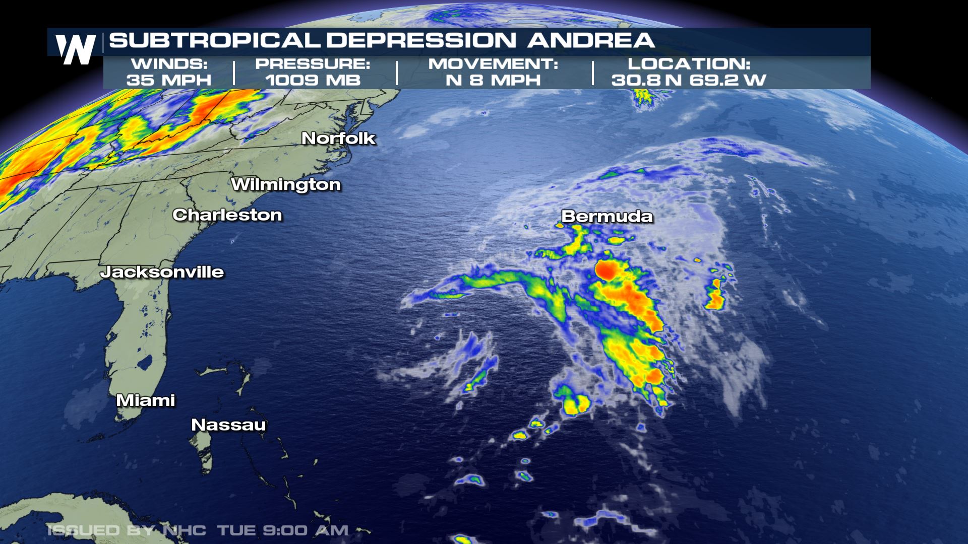
On Monday evening, Subtropical storm Andrea formed in the Atlantic Basin, roughly 335 miles southwest of Bermuda. But, within just 18 hours, the system has already begun to weaken. The National Hurricane Center downgraded Andrea to a subtropical depression by Tuesday morning's update.
As of Tuesday morning, showers and thunderstorms were peppered around the ragged, somewhat disorganized center of Andrea. As of Tuesday morning, the subtropical depression had a central pressure of 1009 mb, with maximum winds of 35 mph- down from 40 mph at the system's peak intensity late Monday. Andrea is moving to the north at about 8 mph.
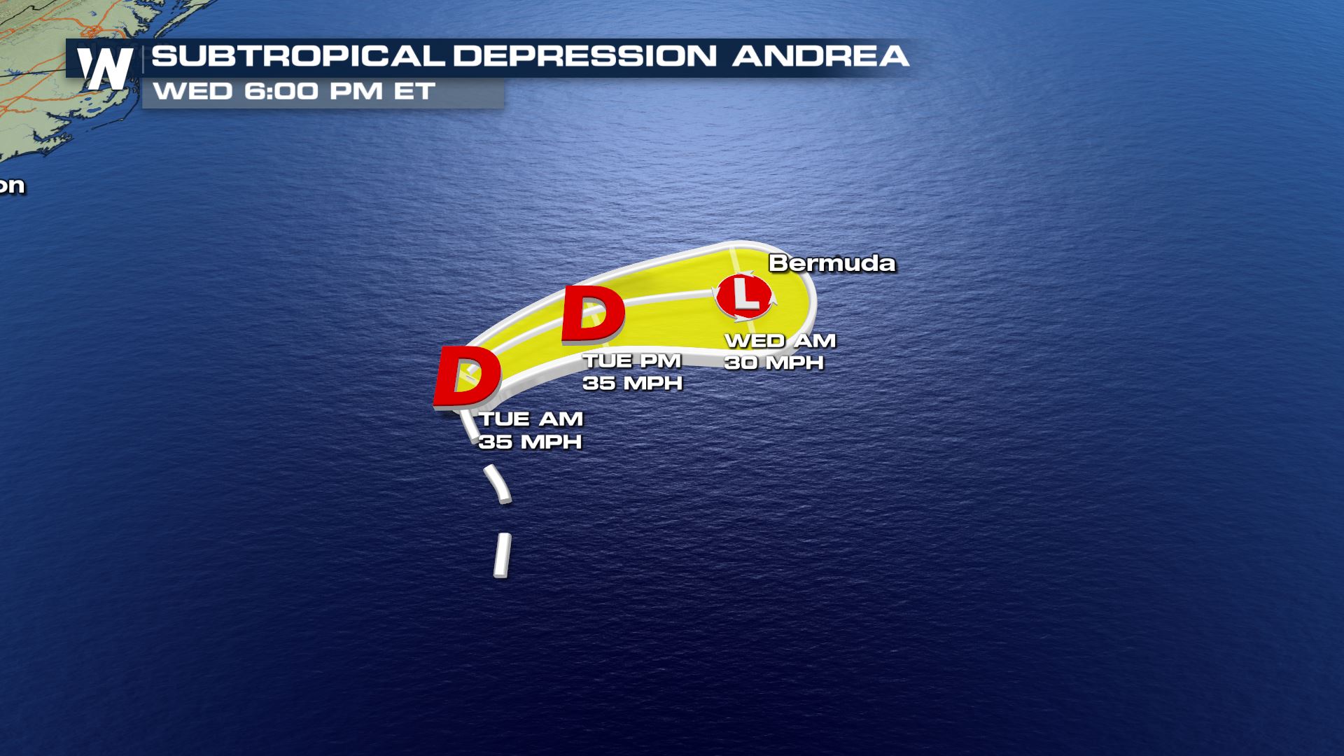
 As Andrea presses northward, upper level winds and a frontal boundary coming off of the United States will interact with Andrea, causing it to turn more to the east. This will also weaken the system significantly as it approaches Bermuda late Tuesday into Wednesday morning.
Andrea is forecast to become a remnant low pressure system before getting close enough to Bermuda. here still could be a round of thunderstorms throughout the day Tuesday for Bermuda with some gusty conditions, with wind gusts near 30 mph.
As Andrea presses northward, upper level winds and a frontal boundary coming off of the United States will interact with Andrea, causing it to turn more to the east. This will also weaken the system significantly as it approaches Bermuda late Tuesday into Wednesday morning.
Andrea is forecast to become a remnant low pressure system before getting close enough to Bermuda. here still could be a round of thunderstorms throughout the day Tuesday for Bermuda with some gusty conditions, with wind gusts near 30 mph.
 Overall, Andrea will bring limited impacts to the island of Bermuda and is not expected to impact any other land. This serves as a great reminder, that hurricane season is coming. June 1 begins the "technical" hurricane season, but as is the case with Andrea, storms can form in the off season.
https://youtu.be/th2cEP4PvYw
Andrea is the first name on the list for 2019.
Overall, Andrea will bring limited impacts to the island of Bermuda and is not expected to impact any other land. This serves as a great reminder, that hurricane season is coming. June 1 begins the "technical" hurricane season, but as is the case with Andrea, storms can form in the off season.
https://youtu.be/th2cEP4PvYw
Andrea is the first name on the list for 2019.

As Andrea presses northward, upper level winds and a frontal boundary coming off of the United States will interact with Andrea, causing it to turn more to the east. This will also weaken the system significantly as it approaches Bermuda late Tuesday into Wednesday morning.
Andrea is forecast to become a remnant low pressure system before getting close enough to Bermuda. here still could be a round of thunderstorms throughout the day Tuesday for Bermuda with some gusty conditions, with wind gusts near 30 mph.
Overall, Andrea will bring limited impacts to the island of Bermuda and is not expected to impact any other land. This serves as a great reminder, that hurricane season is coming. June 1 begins the "technical" hurricane season, but as is the case with Andrea, storms can form in the off season.
https://youtu.be/th2cEP4PvYw
Andrea is the first name on the list for 2019.
All Weather News
More
Fronts Continue To Spark Severe Weather Across the Plains
A cold front that brought record lows to the
18 Jul 2025 10:40 PM

Extreme Heat Impacts for the East Coast & South
Extreme heat continues to impact several area
18 Jul 2025 10:05 PM

Flooding Threat Remains Elevated in the East
A cold front pushing through the Eastern Seab
18 Jul 2025 9:10 PM

EF-2 Firenado from the Deer Creek Fire in Utah
A fire tornado was spotted near La Sal, Utah
18 Jul 2025 7:30 AM

Tropical System Brings Flood Risk to the Central Gulf
Time has run out for notable tropical develop
18 Jul 2025 3:05 AM

Heavy Rain, Flooding Threat Returns to Florida
Keep the rain boots handy in Florida - heavy
13 Jul 2025 12:50 PM

Severe Storm Risk Pushes into the Great Lakes, Ohio Valley
Friday was another busy day with severe weath
12 Jul 2025 8:00 PM