Flooding Threat Continues to Escalate in the Carolinas
Special Stories
16 Sep 2018 4:03 PM
North Carolina and South Carolina continue to get inundated with heavy rain bands that remain nearly stationary across some of the same regions dumping close to 2 feet or more of heavy rain thus far since Florence began impacting the coast late last week.
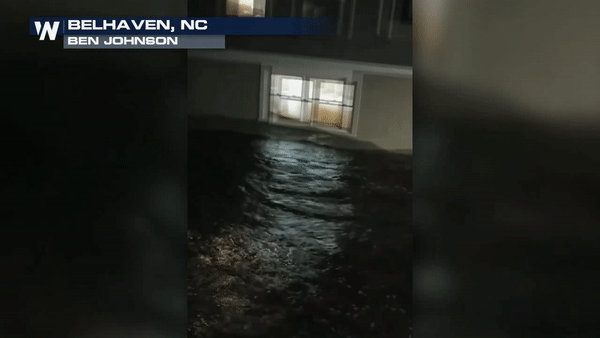
When Florence began closing in on the coast last Thursday it prompted nearly 10 feet of storm surge to move in to places like Belhaven and New Bern yeilding nearly 300 water rescues by early Friday morning
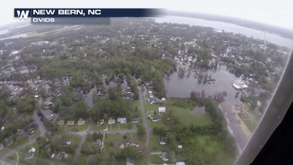
 As Florence slowed to a near crawl over the weekend, it has dumped close to 2 feet of rainfall which is leading to the threat for ongoing freshwater flooding as seen below with the Aerial footage from the National Guard.
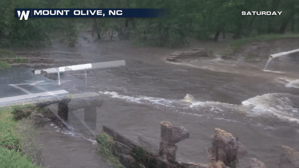
 Several major highways and interstates remain closed across the state as most of these areas remain under under flood waters that are not expected to recede until late next week. Many of the roads are washing out completely as they endure too much stress from the rushing flood waters beneath them.
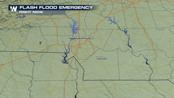
 As of early Sunday, the Charlotte Metro area was under a Flash Flood emergency as rain rates began topping out at 2"/ hour is some areas around the neighborhood of Sherwood Forest which is still seeing rising flood waters from the local rivers and creeks.
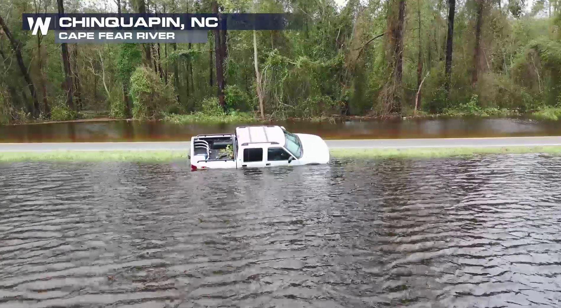
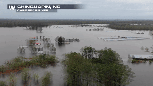
 The video below showing the flooding taking place on Sunday around Chinquapin, NC due to the Cape Fear river overflowing it's banks. Any resident within a mile of the Cape Fear River or the Little River was under Mandatory Evacuations on Sunday ahead of the rising flood waters.
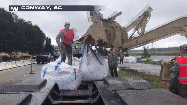
 The National Guard is assisting a Sandbagging operation near Conway, SC ahead of rising flood waters over the next 24 hours.
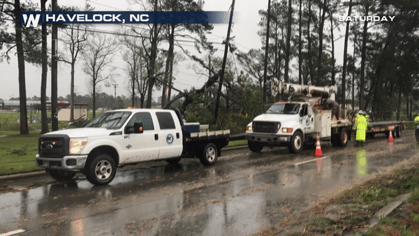
 Nearly a million customers are still without power in the Carolinas. Crews are working endlessly to try and restore power but some areas are not accessible due to flood waters and ongoing torrential downpours.
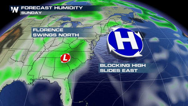
 The big question on everyone's mind is when if FLORENCE going to move it on out and rightfully so.
The short answer is by Monday we will start to see Florence pick up more forward momentum which will take the bulk of the moisture and shift it north into the Virginias and Ohio Valley. There has been essentially nothing to help steer Florence along thus far but as a trough enters from the West this will help Florence pull north at a faster speed. This will allow for some rain to taper off across the coast;however, persistent feeder bands will still be likely even through the day on Monday as the center of low pressure associated with Florence pulls north.
The big question on everyone's mind is when if FLORENCE going to move it on out and rightfully so.
The short answer is by Monday we will start to see Florence pick up more forward momentum which will take the bulk of the moisture and shift it north into the Virginias and Ohio Valley. There has been essentially nothing to help steer Florence along thus far but as a trough enters from the West this will help Florence pull north at a faster speed. This will allow for some rain to taper off across the coast;however, persistent feeder bands will still be likely even through the day on Monday as the center of low pressure associated with Florence pulls north.
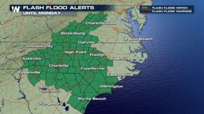
 The Flash Flooding threat is still ongoing and the threat will continue shifting east into the foothills of the Appalachians over the next 6-12 hours. If you live in a low lying area be alert to any Flash Flood Warnings in your region and be prepared to seek higher ground should you need to do so.
 Meteorologist Merry Matthews
As Florence slowed to a near crawl over the weekend, it has dumped close to 2 feet of rainfall which is leading to the threat for ongoing freshwater flooding as seen below with the Aerial footage from the National Guard.
Several major highways and interstates remain closed across the state as most of these areas remain under under flood waters that are not expected to recede until late next week. Many of the roads are washing out completely as they endure too much stress from the rushing flood waters beneath them.
As of early Sunday, the Charlotte Metro area was under a Flash Flood emergency as rain rates began topping out at 2"/ hour is some areas around the neighborhood of Sherwood Forest which is still seeing rising flood waters from the local rivers and creeks.
The video below showing the flooding taking place on Sunday around Chinquapin, NC due to the Cape Fear river overflowing it's banks. Any resident within a mile of the Cape Fear River or the Little River was under Mandatory Evacuations on Sunday ahead of the rising flood waters.
The National Guard is assisting a Sandbagging operation near Conway, SC ahead of rising flood waters over the next 24 hours.
Nearly a million customers are still without power in the Carolinas. Crews are working endlessly to try and restore power but some areas are not accessible due to flood waters and ongoing torrential downpours.
The big question on everyone's mind is when if FLORENCE going to move it on out and rightfully so.
The short answer is by Monday we will start to see Florence pick up more forward momentum which will take the bulk of the moisture and shift it north into the Virginias and Ohio Valley. There has been essentially nothing to help steer Florence along thus far but as a trough enters from the West this will help Florence pull north at a faster speed. This will allow for some rain to taper off across the coast;however, persistent feeder bands will still be likely even through the day on Monday as the center of low pressure associated with Florence pulls north.
The Flash Flooding threat is still ongoing and the threat will continue shifting east into the foothills of the Appalachians over the next 6-12 hours. If you live in a low lying area be alert to any Flash Flood Warnings in your region and be prepared to seek higher ground should you need to do so.
Meteorologist Merry MatthewsAll Weather News
More
Severe Storms Target the Midwest to the Northeast
UPPER MIDWEST - Dangerous tornadoes have alre
28 Jul 2026 1:45 AM

Tropics: Fausto Heads towards Hawaii; Genevieve Cat 4 Hurricane
PacificHurricane Fausto continues to track we
28 Jul 2026 1:45 AM


Southeast Flood Risk Lingers Near Stalled Front
A stalled boundary over the Southeast will ke
25 Jul 2026 10:55 AM

Another Round of Storms Targets the Northeast
Tuesday brought severe weather again across p
23 Jul 2026 1:15 AM

Another Round of Severe Weather for the Upper Midwest and Great Lakes
The upper-level low train continues to keep t
21 Jul 2026 1:45 AM