Fourth Derecho This Year Struck The West Over the Weekend

Top Stories
9 Jun 2020 8:57 AM
If this keep up, 2020 might officially go down as the year of the derecho.
At least four derechos have taken place so far in 2020, an unusually high number for a relatively rare severe weather event.
Derechos are long lines of powerful, wind damage-producing thunderstorms that cover plenty of ground. According to the Storm Prediction Center, a derecho has to travel at least 250 miles, regularly producing winds in excess of 58 mph, with occasional gusts topping 75 mph.
It all started in late April, when an overnight derecho moved south from Missouri to the Gulf Coast, traveling more than 500 miles as it rocked the South with strong winds, large hail and even an EF-2 tornado in Oklahoma.
A deadly derecho moved through the South on May 3rd, killing an off-duty firefighter in Spring Hill, Tennessee. It traveled more than 750 miles and lasted nearly 13 hours, first starting in Kansas before finally petering out in eastern Tennessee.
On June 3rd, a huge line of wind producing storms marched through Pennsylvania and New Jersey, knocking out power to more than a quarter million and leading to winds as high as 93 mph in coastal New Jersey. Philadelphia gusted to 67 mph during this damaging derecho.
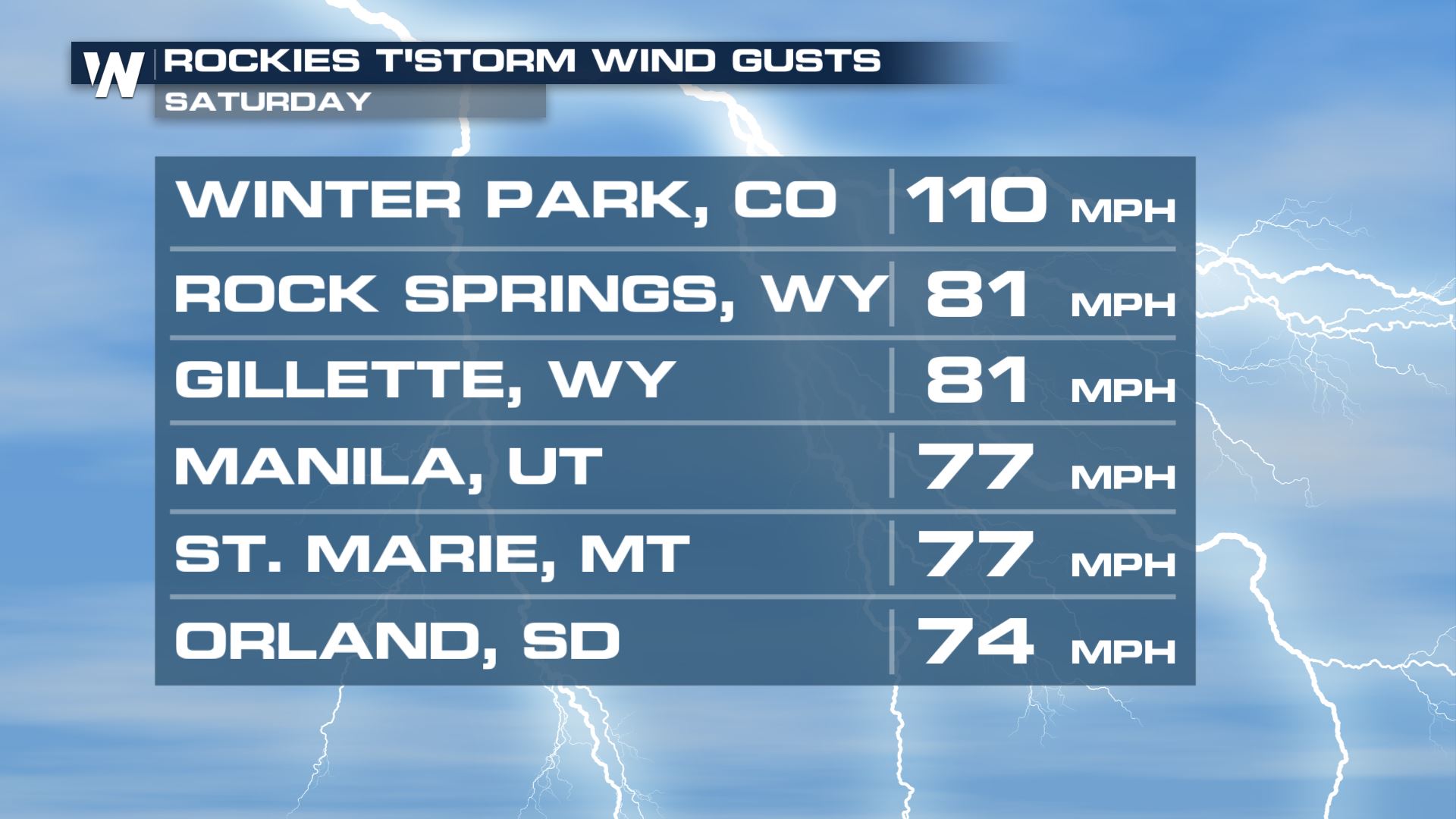
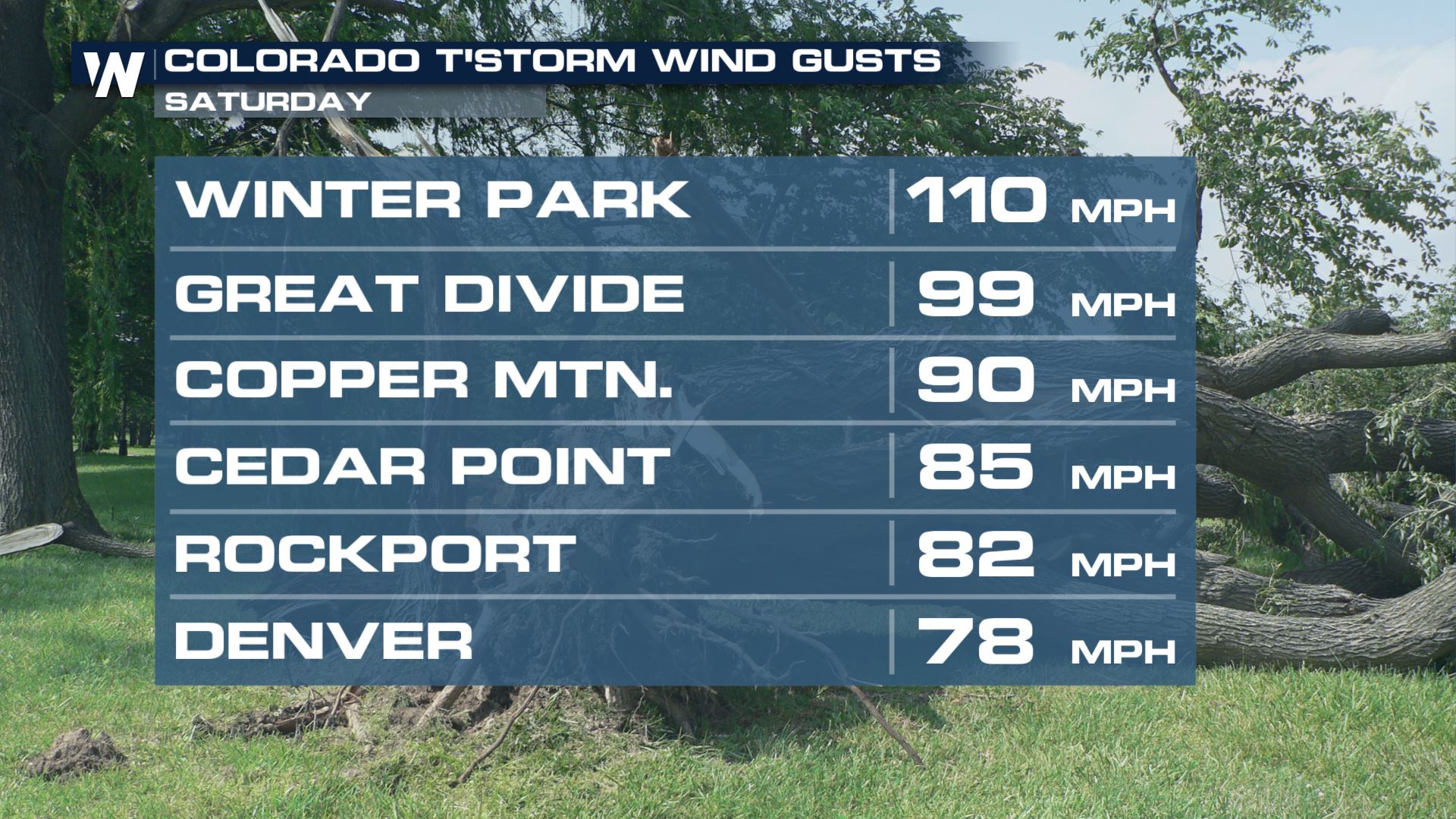
And in the first weekend of June, a powerful derecho took place in a part of the country that rarely sees them: the west. Starting in southern Utah and blasting through Colorado, Nebraska, Wyoming, Nebraska and the Dakotas with winds in excess of 100 mph at times, this violent line led to hundreds of thousands of power outages in those six states.
That's a striking amount of times for a relatively rare severe weather event to strike the same area so many times. Hopefully, Mother Nature's just gotten them out of her system for the rest of the year.
All Weather News
More
Fronts Continue To Spark Severe Weather Across the Plains
A cold front that brought record lows to the
18 Jul 2025 10:40 PM

Extreme Heat Impacts for the East Coast & South
Extreme heat continues to impact several area
18 Jul 2025 10:05 PM

Flooding Threat Remains Elevated in the East
A cold front pushing through the Eastern Seab
18 Jul 2025 9:10 PM

EF-2 Firenado from the Deer Creek Fire in Utah
A fire tornado was spotted near La Sal, Utah
18 Jul 2025 7:30 AM

Tropical System Brings Flood Risk to the Central Gulf
Time has run out for notable tropical develop
18 Jul 2025 3:05 AM

Heavy Rain, Flooding Threat Returns to Florida
Keep the rain boots handy in Florida - heavy
13 Jul 2025 12:50 PM

Severe Storm Risk Pushes into the Great Lakes, Ohio Valley
Friday was another busy day with severe weath
12 Jul 2025 8:00 PM