Getting a Longer Heads-up on El Niño
Special Stories
13 Nov 2018 9:58 AM
[POSTECH] Changes in Atlantic Ocean sea surface temperatures can be used to predict extreme climatic variations known as El Niño and La Niña more than a year in advance, according to research conducted at Korea’s Pohang University of Science and Technology and published in the journal Scientific Reports.
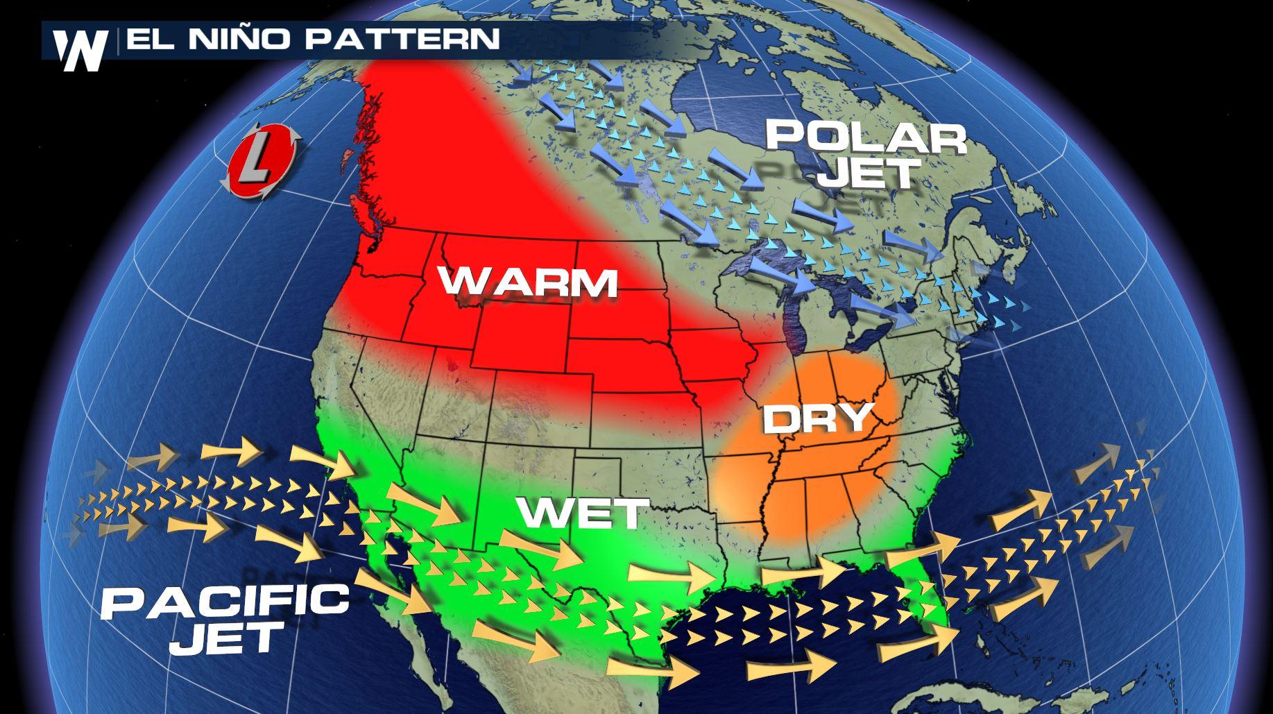
The El Niño Southern Oscillation (ENSO) is an irregular, periodic variation in trade winds and sea and air temperatures in the equatorial region of the Pacific Ocean, . Its warming phase of sea surface temperatures, called El Niño, and cooling phase, called La Niña, affects weather and climate around the world. For example, El Niño conditions typically generate more typhoons in the Pacific Ocean and fewer hurricanes in the Atlantic Ocean, while La Niña conditions usually reverse the trend.
Extensive studies have been conducted to better understand what triggers a distinct oscillation in order to predict associated climatic events. But accurate predictions are still limited to about a year or less before an ENSO swing. For example, studies have found that a peak in warm water in the equatorial Pacific precedes El Niño by about eight months. Also, an abnormal drop in sea surface temperatures in the tropical North Atlantic in early spring precedes El Niño conditions in the Pacific within about nine months.
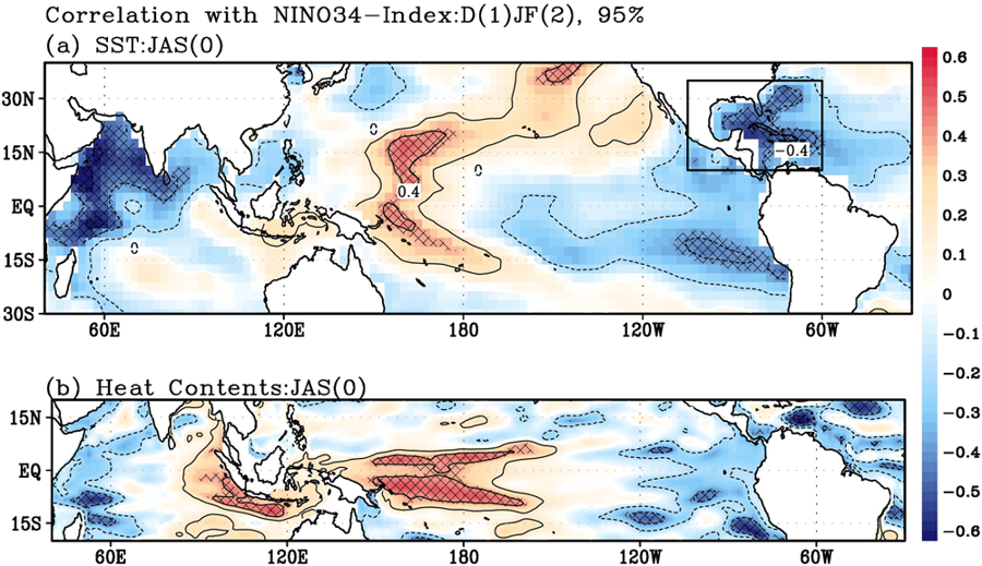 [Relation between sea-surface temperatures (SST) and Nino3.4 index. Lead-lag correlation maps of (a) SST and (b) Heat content (HC) anomalies based on the Niño3.4 index, indicating 17-month lead-lag. Contour intervals are 0.2, and hatching indicates 95% confidence level.]
Now, researchers at Pohang University of Science and Technology and colleagues in Hawaii and Japan have found that an abnormal rise in sea surface temperatures in a large body of warm water, called the Atlantic Warm Pool—comprising the Gulf of Mexico, the Caribbean Sea, and the western tropical North Atlantic—triggers La Niña about 17 months later.
The team analysed observational (1985-2016) and model simulation (1970-2000) data and found an unusual rise of sea surface temperature in the Atlantic Warm Pool in mid-summer to early fall leads to the formation of a northerly wind over the North Pacific. This generates cold sea surface temperatures, high sea level pressure, and a low-level high-pressure area called an anti-cyclone in the subtropical north-eastern Pacific that persist through the subsequent winter and spring. The cold sea surface temperature extends toward the equator. Together, these events lead to a coupling between sea surface temperature and surface winds in the equatorial Pacific in the spring, triggering La Niña. Falling sea surface temperatures in the Atlantic Warm Pool ultimately trigger El Niño. Both ENSO events are triggered 17 months after the initial changes in Atlantic Warm Pool sea surface temperatures.
The robust relationship between these events can provide a longer lead time for ENSO predictions compared to those reported in previous studies, the researchers say. This relationship has only become strong enough for the purpose of these predictions in the past three decades. Before this, it was not statistically significant. Average rising sea surface temperatures in the Atlantic Warm Pool above 28°C seem to be responsible for this, the researchers say.
[Relation between sea-surface temperatures (SST) and Nino3.4 index. Lead-lag correlation maps of (a) SST and (b) Heat content (HC) anomalies based on the Niño3.4 index, indicating 17-month lead-lag. Contour intervals are 0.2, and hatching indicates 95% confidence level.]
Now, researchers at Pohang University of Science and Technology and colleagues in Hawaii and Japan have found that an abnormal rise in sea surface temperatures in a large body of warm water, called the Atlantic Warm Pool—comprising the Gulf of Mexico, the Caribbean Sea, and the western tropical North Atlantic—triggers La Niña about 17 months later.
The team analysed observational (1985-2016) and model simulation (1970-2000) data and found an unusual rise of sea surface temperature in the Atlantic Warm Pool in mid-summer to early fall leads to the formation of a northerly wind over the North Pacific. This generates cold sea surface temperatures, high sea level pressure, and a low-level high-pressure area called an anti-cyclone in the subtropical north-eastern Pacific that persist through the subsequent winter and spring. The cold sea surface temperature extends toward the equator. Together, these events lead to a coupling between sea surface temperature and surface winds in the equatorial Pacific in the spring, triggering La Niña. Falling sea surface temperatures in the Atlantic Warm Pool ultimately trigger El Niño. Both ENSO events are triggered 17 months after the initial changes in Atlantic Warm Pool sea surface temperatures.
The robust relationship between these events can provide a longer lead time for ENSO predictions compared to those reported in previous studies, the researchers say. This relationship has only become strong enough for the purpose of these predictions in the past three decades. Before this, it was not statistically significant. Average rising sea surface temperatures in the Atlantic Warm Pool above 28°C seem to be responsible for this, the researchers say.
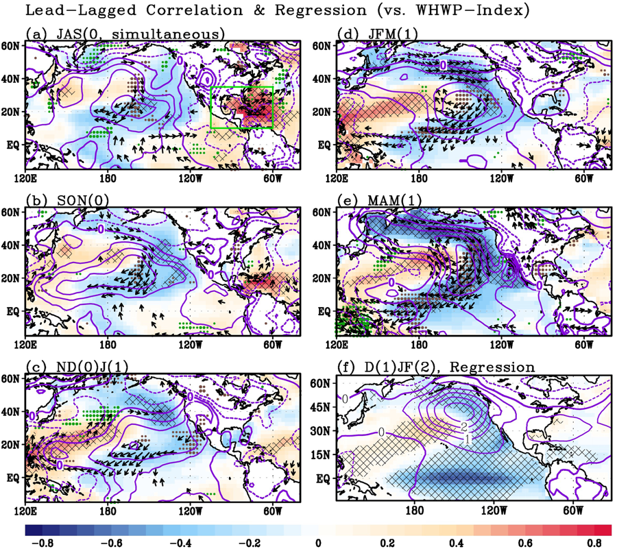 [Lagged influence of sea surface temperatures (SST) on the Pacific. Lagged correlation maps of SST (shading; above 90% confidence level is hatched), sea level pressure, wind (vectors; shown only above 90% confidence level) and precipitation (dots; positive-green, negative-brown; shown only above 90% confidence level)]
They conclude that a model simulation that is able to capture the pattern that occurs between the Atlantic Warm Pool and the El Niño Southern Oscillation in the Pacific could extend the ability of climatologists to predict these swings, and their associated extreme weather and climate impacts, more than a year in advance.
Edited for WeatherNation by Meteorologist Mace Michaels
[Lagged influence of sea surface temperatures (SST) on the Pacific. Lagged correlation maps of SST (shading; above 90% confidence level is hatched), sea level pressure, wind (vectors; shown only above 90% confidence level) and precipitation (dots; positive-green, negative-brown; shown only above 90% confidence level)]
They conclude that a model simulation that is able to capture the pattern that occurs between the Atlantic Warm Pool and the El Niño Southern Oscillation in the Pacific could extend the ability of climatologists to predict these swings, and their associated extreme weather and climate impacts, more than a year in advance.
Edited for WeatherNation by Meteorologist Mace Michaels
[Relation between sea-surface temperatures (SST) and Nino3.4 index. Lead-lag correlation maps of (a) SST and (b) Heat content (HC) anomalies based on the Niño3.4 index, indicating 17-month lead-lag. Contour intervals are 0.2, and hatching indicates 95% confidence level.]
Now, researchers at Pohang University of Science and Technology and colleagues in Hawaii and Japan have found that an abnormal rise in sea surface temperatures in a large body of warm water, called the Atlantic Warm Pool—comprising the Gulf of Mexico, the Caribbean Sea, and the western tropical North Atlantic—triggers La Niña about 17 months later.
The team analysed observational (1985-2016) and model simulation (1970-2000) data and found an unusual rise of sea surface temperature in the Atlantic Warm Pool in mid-summer to early fall leads to the formation of a northerly wind over the North Pacific. This generates cold sea surface temperatures, high sea level pressure, and a low-level high-pressure area called an anti-cyclone in the subtropical north-eastern Pacific that persist through the subsequent winter and spring. The cold sea surface temperature extends toward the equator. Together, these events lead to a coupling between sea surface temperature and surface winds in the equatorial Pacific in the spring, triggering La Niña. Falling sea surface temperatures in the Atlantic Warm Pool ultimately trigger El Niño. Both ENSO events are triggered 17 months after the initial changes in Atlantic Warm Pool sea surface temperatures.
The robust relationship between these events can provide a longer lead time for ENSO predictions compared to those reported in previous studies, the researchers say. This relationship has only become strong enough for the purpose of these predictions in the past three decades. Before this, it was not statistically significant. Average rising sea surface temperatures in the Atlantic Warm Pool above 28°C seem to be responsible for this, the researchers say.
[Lagged influence of sea surface temperatures (SST) on the Pacific. Lagged correlation maps of SST (shading; above 90% confidence level is hatched), sea level pressure, wind (vectors; shown only above 90% confidence level) and precipitation (dots; positive-green, negative-brown; shown only above 90% confidence level)]
They conclude that a model simulation that is able to capture the pattern that occurs between the Atlantic Warm Pool and the El Niño Southern Oscillation in the Pacific could extend the ability of climatologists to predict these swings, and their associated extreme weather and climate impacts, more than a year in advance.
Edited for WeatherNation by Meteorologist Mace MichaelsAll Weather News
More
Severe Storms Target the Midwest to the Northeast
UPPER MIDWEST - Dangerous tornadoes have alre
28 Jul 2026 1:45 AM

Tropics: Fausto Heads towards Hawaii; Genevieve Cat 4 Hurricane
PacificHurricane Fausto continues to track we
28 Jul 2026 1:45 AM


Southeast Flood Risk Lingers Near Stalled Front
A stalled boundary over the Southeast will ke
25 Jul 2026 10:55 AM

Another Round of Storms Targets the Northeast
Tuesday brought severe weather again across p
23 Jul 2026 1:15 AM

Another Round of Severe Weather for the Upper Midwest and Great Lakes
The upper-level low train continues to keep t
21 Jul 2026 1:45 AM