GOES East Satellite Captures the First Images from Space of Gigantic Jet Lightning
Special Stories
28 Mar 2018 3:20 PM
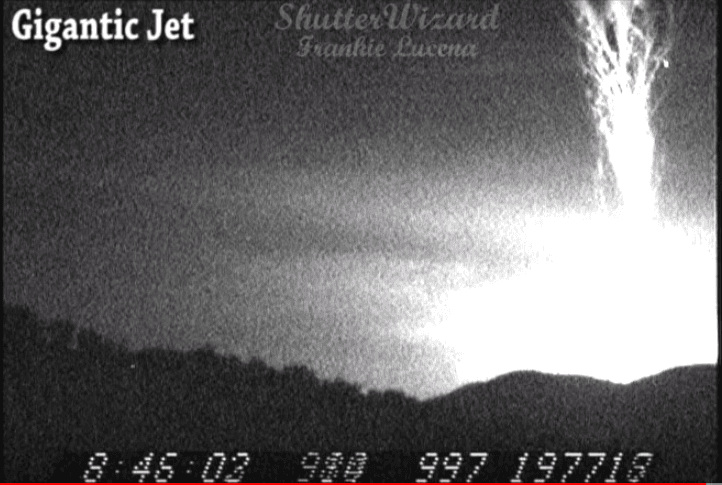
NOAA GOES East (GOES-16) satellite's Geostationary Lightning Mapper has captured the first images from space of 'gigantic jet' lightning - electrical discharges from a thunderstorm that come out the TOP of the storm and reach as high as the ionosphere (that's 50 miles up).
https://www.youtube.com/watch?v=sy7zRwDRLbk&feature=youtu.be
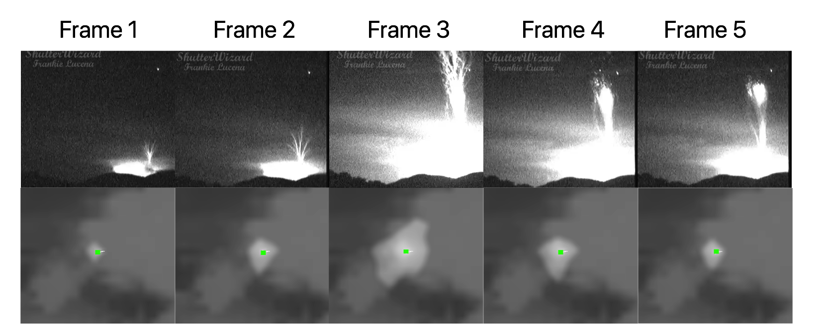 [The image above shows a comparison in the optical energy from GLM and the camera on the ground. Video Credit: Frankie Lucena, Research credit: Levi Boggs, Florida Tech]
Thunderstorms can produce electrical discharges that come out the top of the storm and reach the ionosphere (50 miles altitude). These are known as gigantic jets. Jets have predominantly been recorded by cameras on the ground. However, new research using the GOES-16 Geostationary Lightning Mapper has identified gigantic jets from space that were produced by Tropical Storm Harvey on Aug 19, 2017, as it passed Puerto Rico. This research can lead to a better understanding of these spectacular discharges and determine when and where they take place.
[The image above shows a comparison in the optical energy from GLM and the camera on the ground. Video Credit: Frankie Lucena, Research credit: Levi Boggs, Florida Tech]
Thunderstorms can produce electrical discharges that come out the top of the storm and reach the ionosphere (50 miles altitude). These are known as gigantic jets. Jets have predominantly been recorded by cameras on the ground. However, new research using the GOES-16 Geostationary Lightning Mapper has identified gigantic jets from space that were produced by Tropical Storm Harvey on Aug 19, 2017, as it passed Puerto Rico. This research can lead to a better understanding of these spectacular discharges and determine when and where they take place.
 [The chart above shows 5 frames of the gigantic lightning jet - electrical discharges from a thunderstorm that come out the TOP of the storm and reach as high as the ionosphere (50 miles up)]
Edited for WeatherNation by Meteorologist Mace Michaels
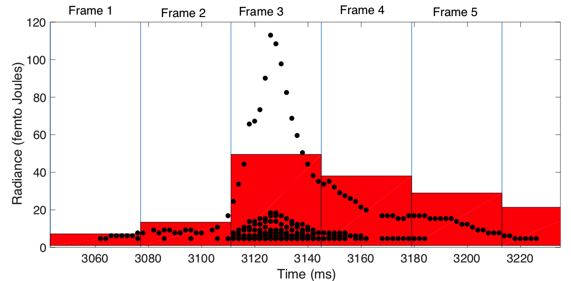
[The chart above shows 5 frames of the gigantic lightning jet - electrical discharges from a thunderstorm that come out the TOP of the storm and reach as high as the ionosphere (50 miles up)]
Edited for WeatherNation by Meteorologist Mace Michaels
[The image above shows a comparison in the optical energy from GLM and the camera on the ground. Video Credit: Frankie Lucena, Research credit: Levi Boggs, Florida Tech]
Thunderstorms can produce electrical discharges that come out the top of the storm and reach the ionosphere (50 miles altitude). These are known as gigantic jets. Jets have predominantly been recorded by cameras on the ground. However, new research using the GOES-16 Geostationary Lightning Mapper has identified gigantic jets from space that were produced by Tropical Storm Harvey on Aug 19, 2017, as it passed Puerto Rico. This research can lead to a better understanding of these spectacular discharges and determine when and where they take place.
[The chart above shows 5 frames of the gigantic lightning jet - electrical discharges from a thunderstorm that come out the TOP of the storm and reach as high as the ionosphere (50 miles up)]
Edited for WeatherNation by Meteorologist Mace MichaelsAll Weather News
More
Severe Storm Threat Returns to the Midwest
After several tornadoes ripped through the Mi
30 Jul 2026 9:30 PM


After Reaching Category 5, Genevieve Weakens in the Pacific
PacificFausto is now a post-tropical cyclone.
30 Jul 2026 12:00 PM

Flooding Risk Increases as Heavy Rain Targets the Tri-State Area
Tuesday, heavy rainfall moved across the Nort
30 Jul 2026 12:25 AM

Severe Weather: Energy From the Midwest Now in the Southeast
UPPER MIDWEST - Through Monday, dangerous tor
29 Jul 2026 10:30 PM

Southeast Flood Risk Lingers Near Stalled Front
A stalled boundary over the Southeast will ke
25 Jul 2026 10:55 AM