Gulf Coast on Watch for Possible Tropical Development

Top Stories
1 Sep 2018 9:33 PM
The northern Gulf Coast must monitor the forecast for incoming tropical rain, some of which may develop into something stronger.
The National Hurricane Center, as of Saturday evening, was giving a tropical wave a 50% chance of developing in the northern Gulf of Mexico.
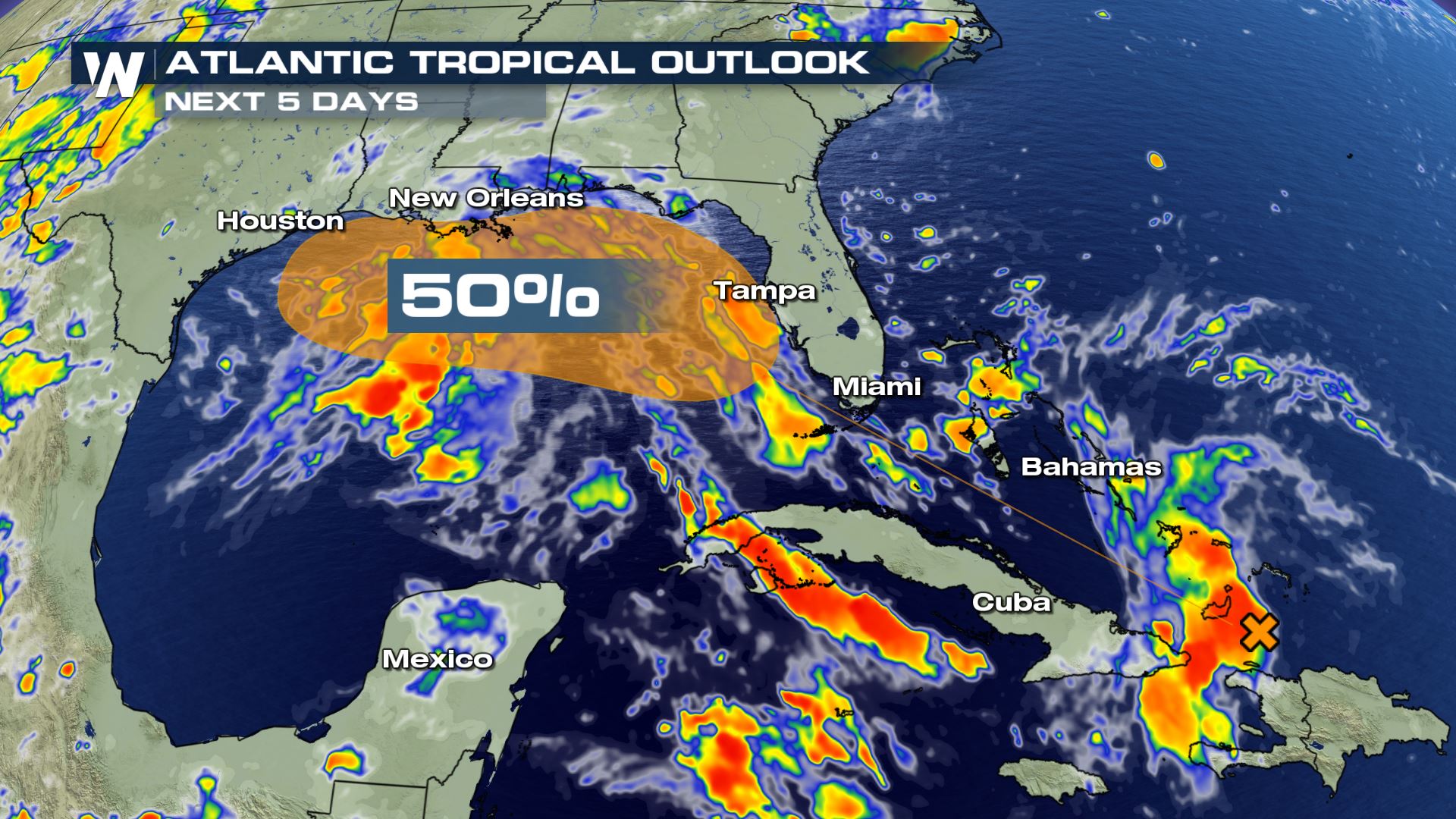 Saturday evening, the tropical wave was located over the Bahamas, indicated by the orange X above. It is forecast to move toward Florida through Monday and then into the Gulf of Mexico either Monday night or Tuesday. That is when the National Hurricane Center is expecting conditions to become more favorable for development.
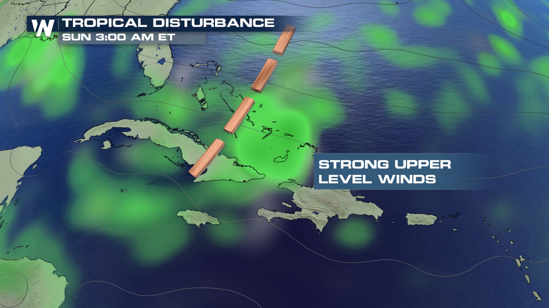 Right now, disruptive winds known as wind shear are limiting the tropical wave's development.
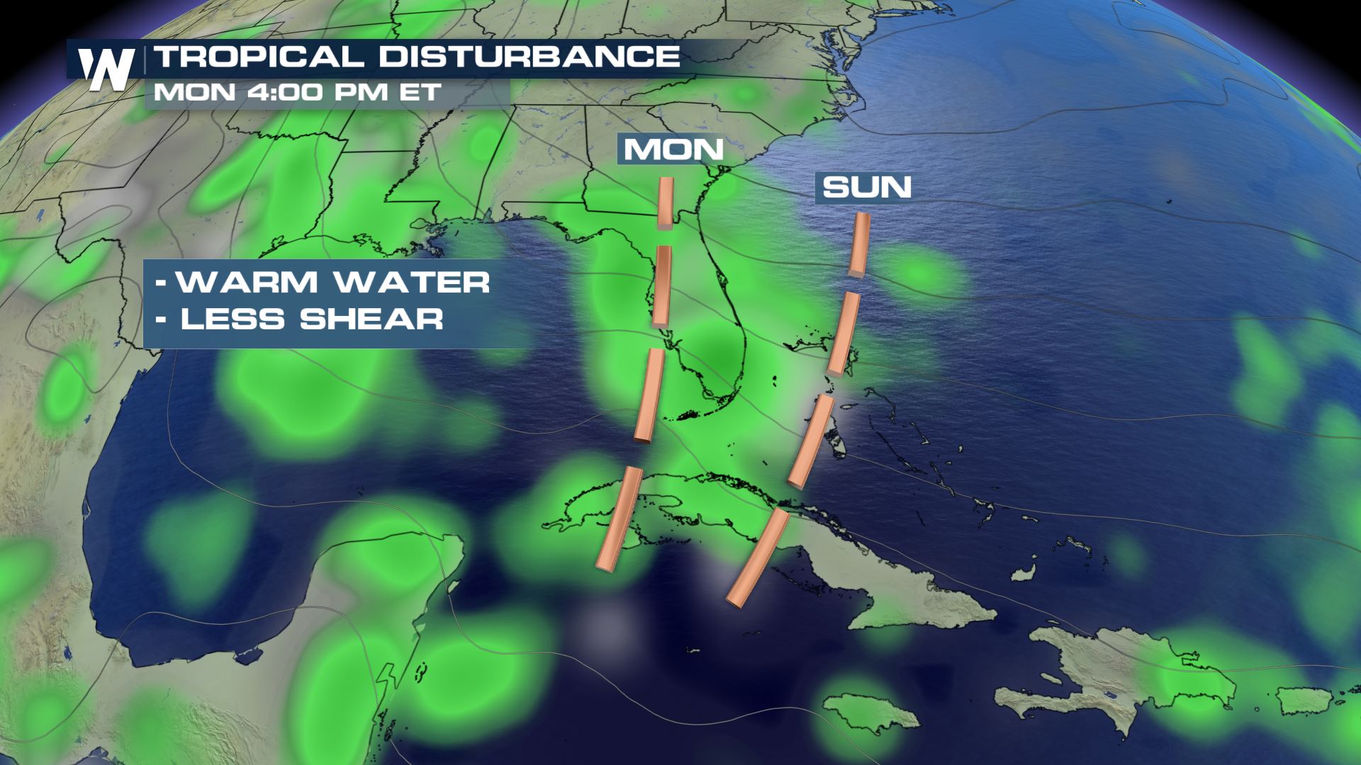 By Labor Day and the upcoming week, the wind shear is forecast to relax as the tropical wave moves over warmer sea surface temperatures. The combination may help this wave strengthen into a tropical depression.
What does this mean for you along the Gulf? As of Saturday evening, no immediate action was needed. However, check in with us multiple times each day to learn the very latest with this tropical wave. Regardless of development, pockets of heavy rain will be likely from Texas to Florida's panhandle between Sunday and Tuesday, so plan on some wet days (at times) ahead.
For WeatherNation, Meteorologist Steve Glazier
By Labor Day and the upcoming week, the wind shear is forecast to relax as the tropical wave moves over warmer sea surface temperatures. The combination may help this wave strengthen into a tropical depression.
What does this mean for you along the Gulf? As of Saturday evening, no immediate action was needed. However, check in with us multiple times each day to learn the very latest with this tropical wave. Regardless of development, pockets of heavy rain will be likely from Texas to Florida's panhandle between Sunday and Tuesday, so plan on some wet days (at times) ahead.
For WeatherNation, Meteorologist Steve Glazier
Saturday evening, the tropical wave was located over the Bahamas, indicated by the orange X above. It is forecast to move toward Florida through Monday and then into the Gulf of Mexico either Monday night or Tuesday. That is when the National Hurricane Center is expecting conditions to become more favorable for development.
Right now, disruptive winds known as wind shear are limiting the tropical wave's development.
By Labor Day and the upcoming week, the wind shear is forecast to relax as the tropical wave moves over warmer sea surface temperatures. The combination may help this wave strengthen into a tropical depression.
What does this mean for you along the Gulf? As of Saturday evening, no immediate action was needed. However, check in with us multiple times each day to learn the very latest with this tropical wave. Regardless of development, pockets of heavy rain will be likely from Texas to Florida's panhandle between Sunday and Tuesday, so plan on some wet days (at times) ahead.
For WeatherNation, Meteorologist Steve GlazierAll Weather News
More
Tropics: Fausto Heads to Hawaii; Genevieve Will Become a Major Hurricane
Atlantic BasinBertha has dissipated after mov
25 Jul 2026 7:25 PM


Severe Storms Target the Midwest This Weekend
Extreme heat will be a big story this week ac
25 Jul 2026 7:10 PM

Heat Wave Grips Central, Western U.S.
Are you over the summer heat yet? SouthwestEx
25 Jul 2026 5:20 PM

Southeast Flood Risk Lingers Near Stalled Front
A stalled boundary over the Southeast will ke
25 Jul 2026 10:55 AM

Another Round of Storms Targets the Northeast
Tuesday brought severe weather again across p
23 Jul 2026 1:15 AM

Another Round of Severe Weather for the Upper Midwest and Great Lakes
The upper-level low train continues to keep t
21 Jul 2026 1:45 AM