Happening Now: Heavy Rain, Flooding Threatening Houston & Southeast Texas
Special Stories
4 Jul 2018 11:42 AM
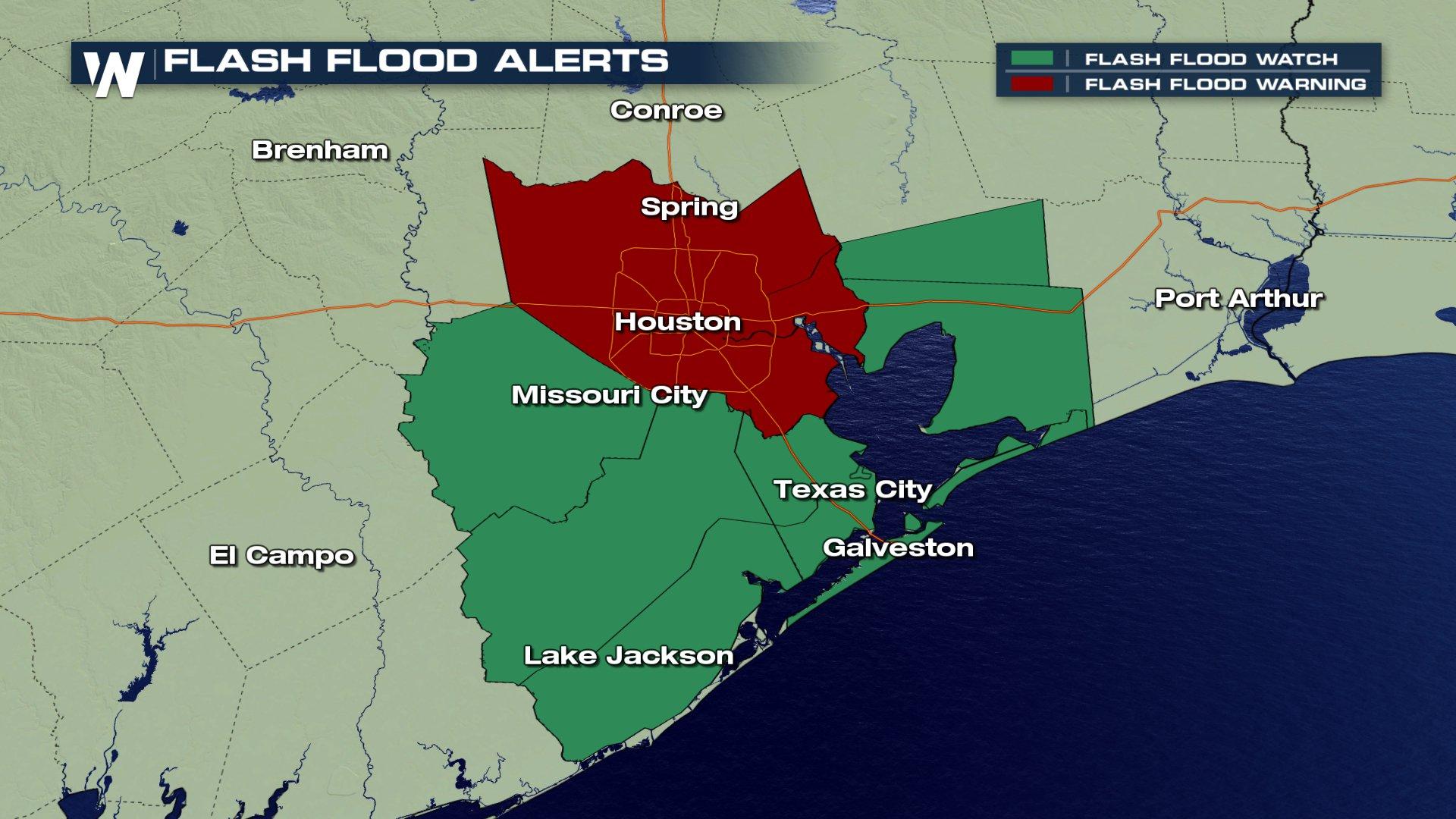
Heavy rain continues to fall across Southeast Texas, including for cities like Houston. Due to the heavy rain and the amount of rain that has already fallen, flooding alerts have been issued for this part of the state.
 According to the National Weather Service, between 3 and 6 inches of rain has already fallen across south central Harris County, the county where Houston is located, with more rain on the way. Rainfall rates at times have ranged between 3 to 4 inches over western Houston, leading to some urban roadways being flooded.
https://twitter.com/WeatherNation/status/1014554533068853249
Areas experiencing flooding include Northern Missouri City, Bellaire, West University Place, Galena Park, Jacinto City, Hunters Creek Village, Bunker Hill Village, Piney Point Village, Midtown Houston, Downtown Houston, Greenway / Upper Kirby Area, Second Ward, Greater Heights, Neartown / Montrose, Greater Eastwood, Near Northside Houston, Greater Fifth Ward, Memorial Park, and the Greater Third Ward and Fourth Ward.
This rainfall is due to a broad mid-level low pressure system centered over Galveston Bay that is helping to producing intense showers and thunderstorms. This low is showing signs of weakening, but is still helping to produce significant rain. You can check live radar here.
https://twitter.com/WeatherNation/status/1014537046398984192
The forecast calls for more rain over the next several hours. It's always encouraged to turn away from and do not drive in flooded roads. Driving through flooded roads puts the life of the driver and any passengers in the vehicle at risk. Most flood deaths occur in vehicles.
Stay with WeatherNation for the latest.
According to the National Weather Service, between 3 and 6 inches of rain has already fallen across south central Harris County, the county where Houston is located, with more rain on the way. Rainfall rates at times have ranged between 3 to 4 inches over western Houston, leading to some urban roadways being flooded.
https://twitter.com/WeatherNation/status/1014554533068853249
Areas experiencing flooding include Northern Missouri City, Bellaire, West University Place, Galena Park, Jacinto City, Hunters Creek Village, Bunker Hill Village, Piney Point Village, Midtown Houston, Downtown Houston, Greenway / Upper Kirby Area, Second Ward, Greater Heights, Neartown / Montrose, Greater Eastwood, Near Northside Houston, Greater Fifth Ward, Memorial Park, and the Greater Third Ward and Fourth Ward.
This rainfall is due to a broad mid-level low pressure system centered over Galveston Bay that is helping to producing intense showers and thunderstorms. This low is showing signs of weakening, but is still helping to produce significant rain. You can check live radar here.
https://twitter.com/WeatherNation/status/1014537046398984192
The forecast calls for more rain over the next several hours. It's always encouraged to turn away from and do not drive in flooded roads. Driving through flooded roads puts the life of the driver and any passengers in the vehicle at risk. Most flood deaths occur in vehicles.
Stay with WeatherNation for the latest.
All Weather News
More

Flooding Risk Increases as Heavy Rain Targets the Tri-State Area
TRI-STATE AREA - Along with the threat of sev
29 Jul 2026 2:00 AM

Tropics: Fausto Heads towards Hawaii; Genevieve a Major Hurricane
PacificTropical Storm Fausto continues to tra
29 Jul 2026 1:35 AM


Southeast Flood Risk Lingers Near Stalled Front
A stalled boundary over the Southeast will ke
25 Jul 2026 10:55 AM

Another Round of Storms Targets the Northeast
Tuesday brought severe weather again across p
23 Jul 2026 1:15 AM