Heightened Risk For Flash Flooding in the Northeast
Top Stories
18 Jul 2021 10:01 AM
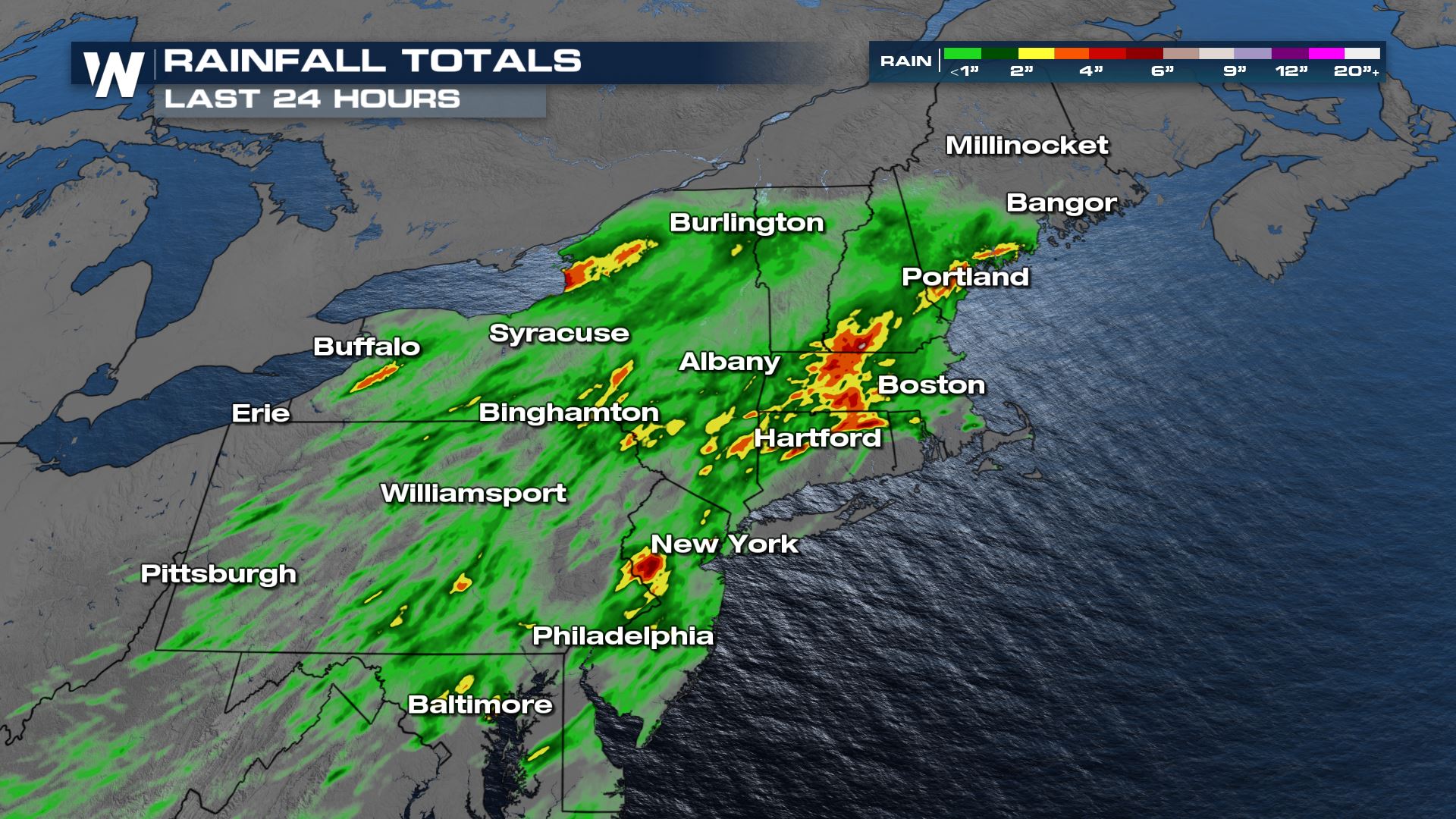
Ongoing heavy rain will likely lead to numerous instances of flash flooding today with improving conditions into Monday. The last 24 hours have produced several locations with over 4" of rain.
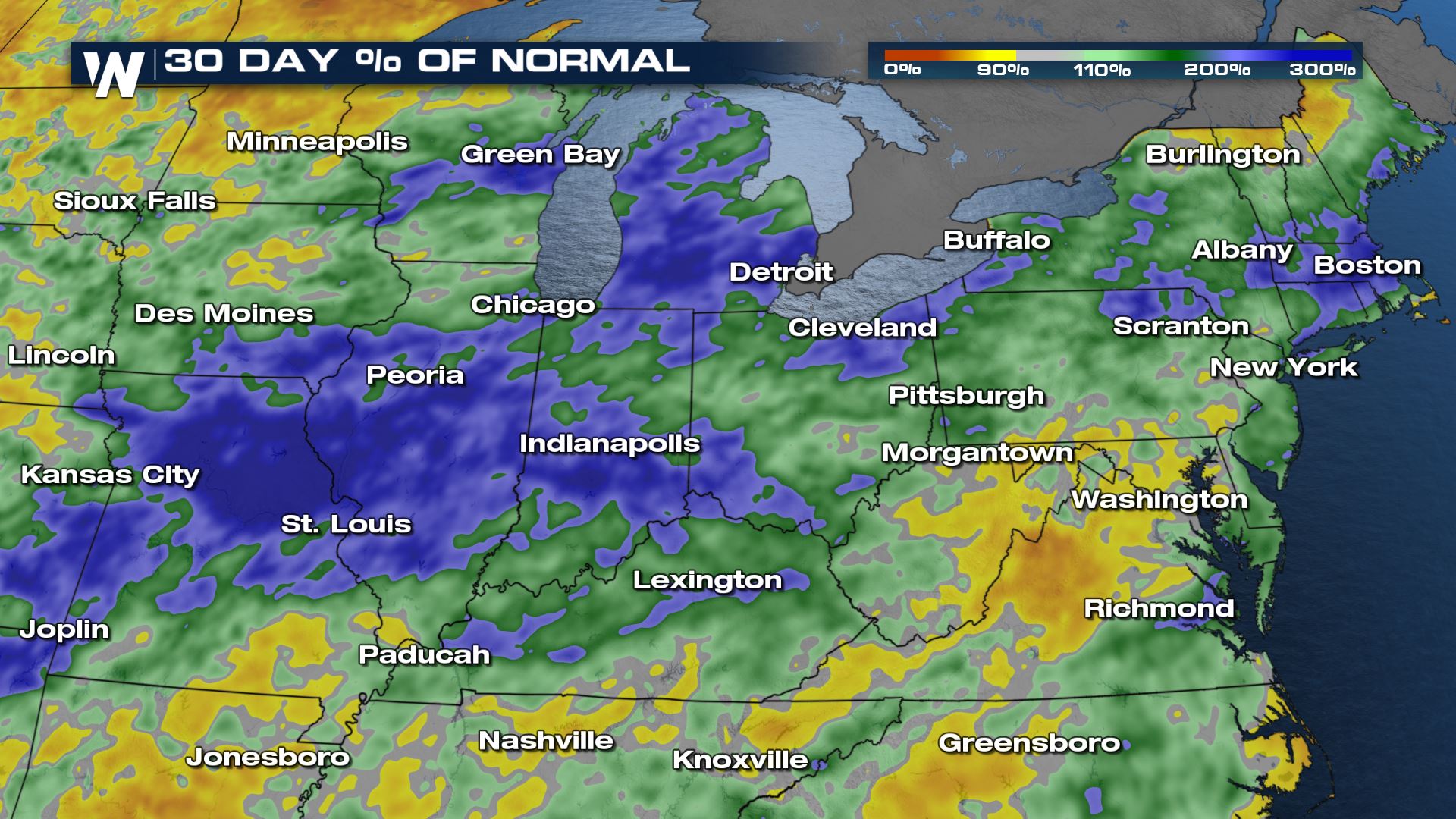
 Over the past few days, the heavy rain has been focused across the Central Plains and Midwest, leading to flash flooding in major metropolitan areas like Detroit. Many of these locations, including in New England, have seen 200-300% of their normal rainfall over the last 30 days, leading to saturated soils and runoff that develops more quickly. These areas need less total rain for flash flooding.
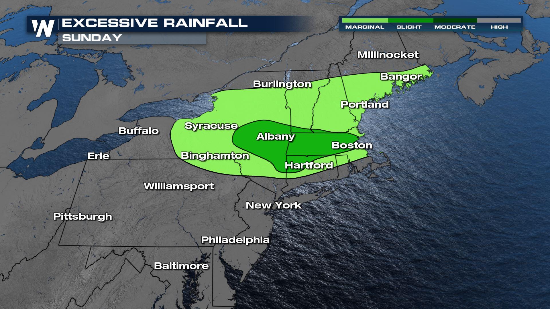
 The Weather Prediction Center (WPC) has issued a slight risk for flash flooding on Sunday in the Northeast. This is a level 2 out of 4 risk for flash flooding, which means numerous instances of flash flooding can be expected in the lime green region but anywhere shaded should be on alert today.
 Storms are expected to be much more isolated as the day progresses, which is why the risk level is marginal and slight across portions of the Northeast for the time frame that ends early Monday morning.
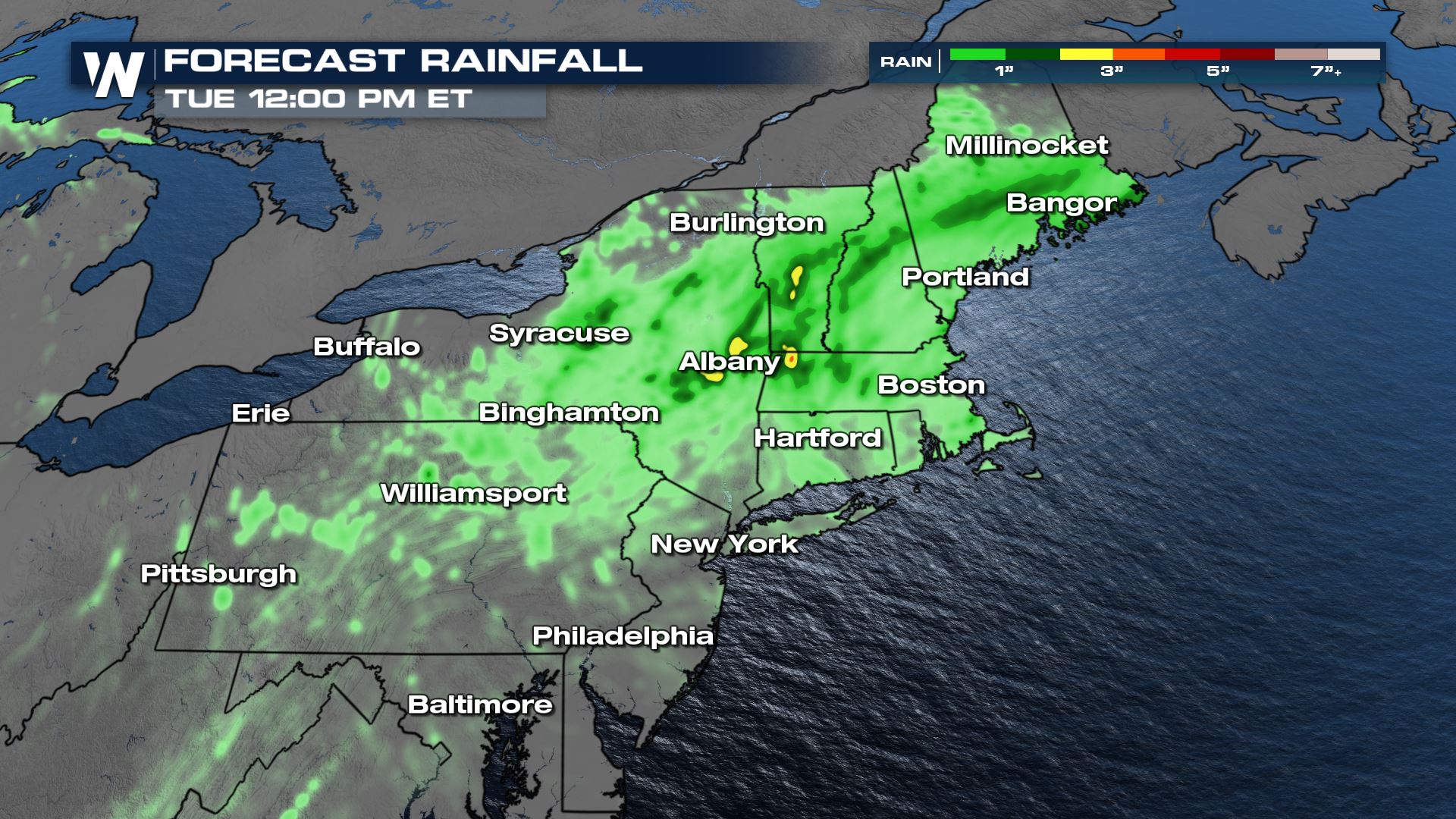
Rainfall totals could exceed 3 inches in many locations, with the majority picking up an additional 1" to 2".
Storms are expected to be much more isolated as the day progresses, which is why the risk level is marginal and slight across portions of the Northeast for the time frame that ends early Monday morning.
Rainfall totals could exceed 3 inches in many locations, with the majority picking up an additional 1" to 2".
 Never drive through or walk through flood waters. Stay up to date with the latest weather information as this flood threat persists. Your Northeastern regional forecast can always be viewed on our app or on our livestream at 10 past the hour.
Over the past few days, the heavy rain has been focused across the Central Plains and Midwest, leading to flash flooding in major metropolitan areas like Detroit. Many of these locations, including in New England, have seen 200-300% of their normal rainfall over the last 30 days, leading to saturated soils and runoff that develops more quickly. These areas need less total rain for flash flooding.
Forecast / Alerts
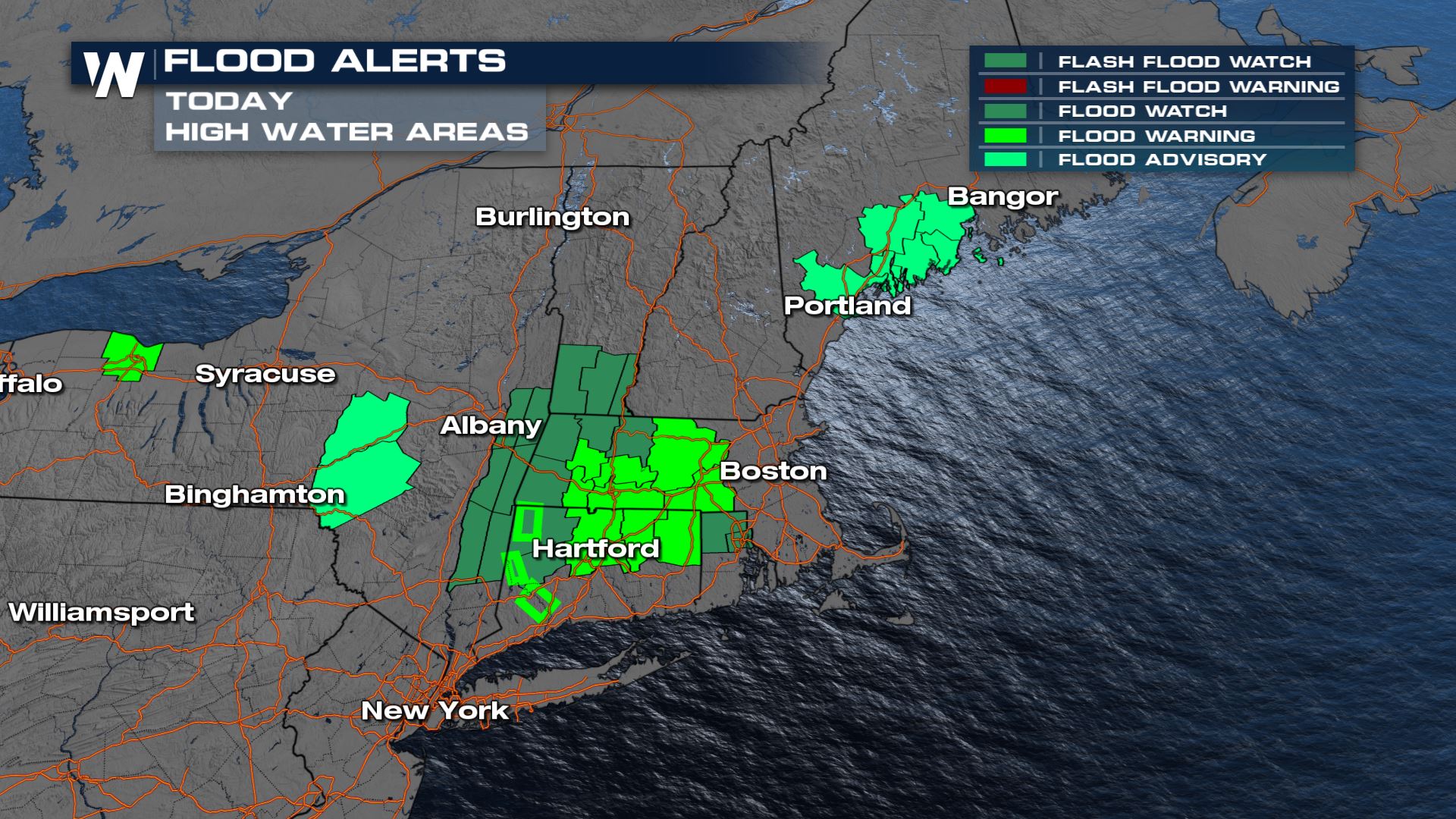
Flash flood watches are in effect through Sunday in the Northeast, with some flooding alerts in place for imminent flooding ongoing from the steady morning rain.
The Weather Prediction Center (WPC) has issued a slight risk for flash flooding on Sunday in the Northeast. This is a level 2 out of 4 risk for flash flooding, which means numerous instances of flash flooding can be expected in the lime green region but anywhere shaded should be on alert today.
Storms are expected to be much more isolated as the day progresses, which is why the risk level is marginal and slight across portions of the Northeast for the time frame that ends early Monday morning.
Rainfall totals could exceed 3 inches in many locations, with the majority picking up an additional 1" to 2".
Never drive through or walk through flood waters. Stay up to date with the latest weather information as this flood threat persists. Your Northeastern regional forecast can always be viewed on our app or on our livestream at 10 past the hour.All Weather News
More
Fronts Continue To Spark Severe Weather Across the Plains
A cold front that brought record lows to the
18 Jul 2025 10:40 PM

Extreme Heat Impacts for the East Coast & South
Extreme heat continues to impact several area
18 Jul 2025 10:05 PM

Flooding Threat Remains Elevated in the East
A cold front pushing through the Eastern Seab
18 Jul 2025 9:10 PM

EF-2 Firenado from the Deer Creek Fire in Utah
A fire tornado was spotted near La Sal, Utah
18 Jul 2025 7:30 AM

Tropical System Brings Flood Risk to the Central Gulf
Time has run out for notable tropical develop
18 Jul 2025 3:05 AM

Heavy Rain, Flooding Threat Returns to Florida
Keep the rain boots handy in Florida - heavy
13 Jul 2025 12:50 PM

Severe Storm Risk Pushes into the Great Lakes, Ohio Valley
Friday was another busy day with severe weath
12 Jul 2025 8:00 PM