Historic Rainfall & Flooding in Tennessee
Special Stories
24 Feb 2019 6:13 PM
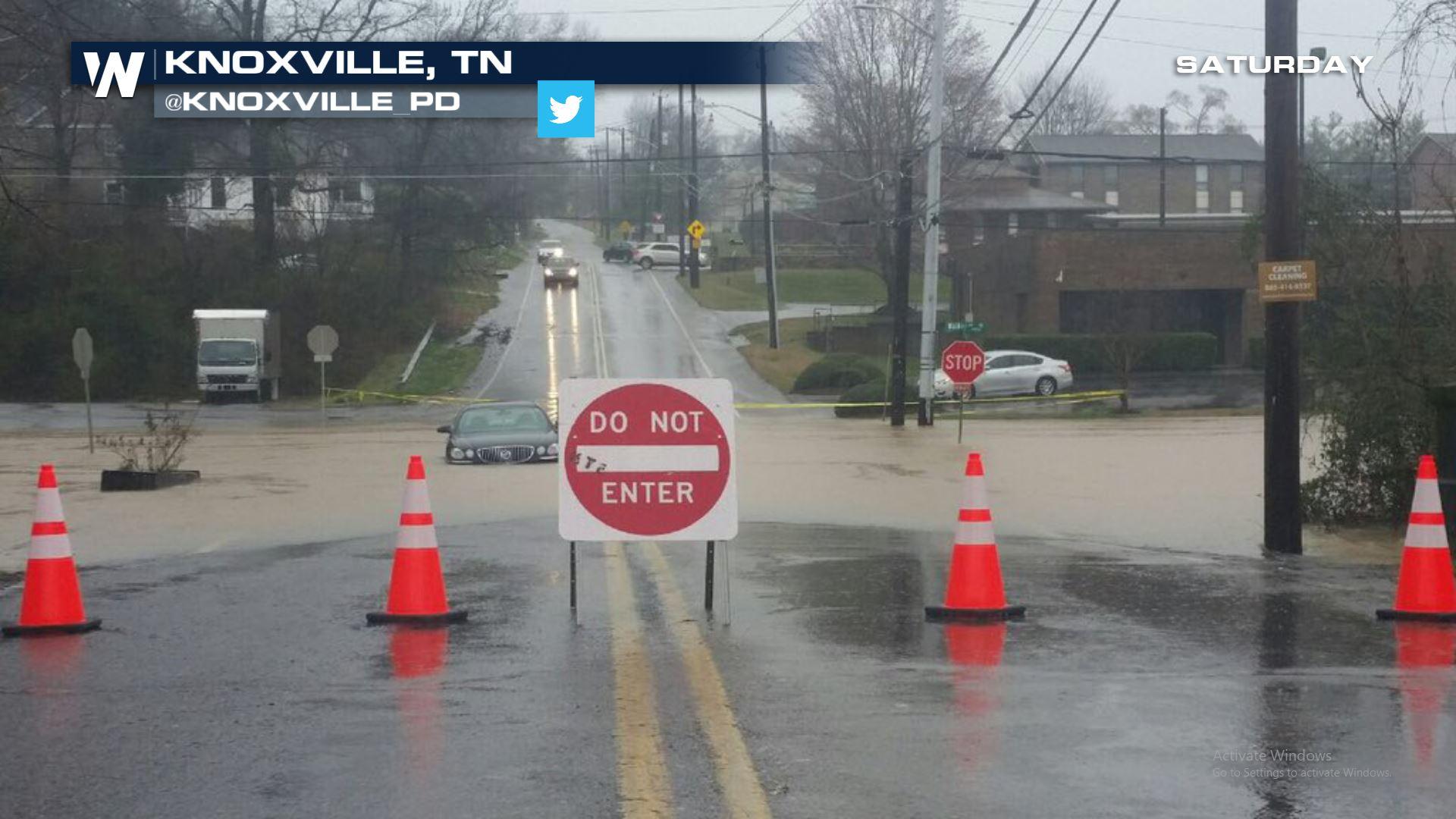
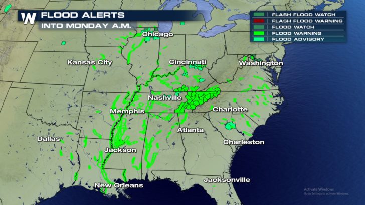
Heavy rainfall late last week led to widespread flooding across many Southeastern states and areas as far north as the Ohio Valley. One state hit particularly hard was Tennessee, where the governor declared a Level 3 State of Emergency. Floodwaters covered roadways, people had to be rescued by emergency officials, and rivers overflowed their banks. River levels will continue to rise this week.
https://twitter.com/TVAnews/status/1099790112261660673
Not only did river flooding and flash flooding occur, there were mudslide concerns in many of the state's mountainous areas.
https://twitter.com/WeatherNation/status/1099804936689278977
Many cities experienced record rainfall. On Saturday alone, the city of Knoxville was inundated with over 5 inches, setting a new record for February 23rd.
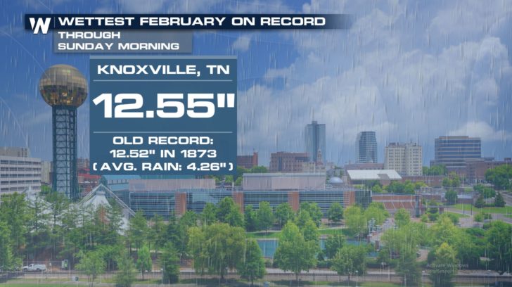
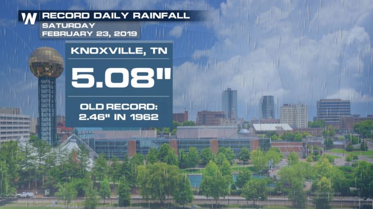 Saturday's total pushed February's monthly rainfall up to 12.55 inches. February 2019 is now the wettest February in Knoxville's history, surpassing a record that has stood for 146 years! Weather records have been kept in Knoxville since 1871.
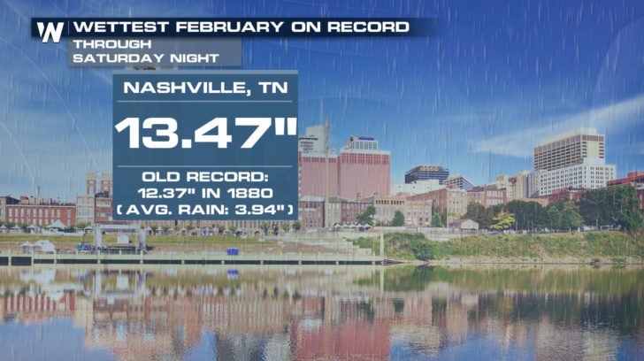
 In the state capital of Nashville, a similar record was set this month. February 2019 is now their wettest February with a total of 13.47 inches. This surpasses a record set 139 years ago in the Music City.
 February 2019 brought copious amounts of rain to many other cities in Tennessee and the surrounding states. The local National Weather Service office in Nashville mentioned that approximately 10 to 15 inches of rain has fallen throughout much of Middle Tennessee.
https://twitter.com/NWSNashville/status/1099738686118338560
Because of the significant rainfall, river levels are expected to remain high through the end of the month. Record crest levels are forecast on several waterways.
February 2019 brought copious amounts of rain to many other cities in Tennessee and the surrounding states. The local National Weather Service office in Nashville mentioned that approximately 10 to 15 inches of rain has fallen throughout much of Middle Tennessee.
https://twitter.com/NWSNashville/status/1099738686118338560
Because of the significant rainfall, river levels are expected to remain high through the end of the month. Record crest levels are forecast on several waterways.
 https://twitter.com/NWSMemphis/status/1099504509146025985
https://twitter.com/NWSMemphis/status/1099508789437435909
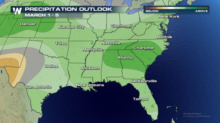
Looking ahead to early March, the Climate Prediction Center paints a wetter-than-normal picture across much of the southeastern United States.
https://twitter.com/NWSMemphis/status/1099504509146025985
https://twitter.com/NWSMemphis/status/1099508789437435909
Looking ahead to early March, the Climate Prediction Center paints a wetter-than-normal picture across much of the southeastern United States.
 Be sure to follow WeatherNation on Facebook and Twitter for the latest forecast information.
- Meteorologist Joe Astolfi
Be sure to follow WeatherNation on Facebook and Twitter for the latest forecast information.
- Meteorologist Joe Astolfi
Saturday's total pushed February's monthly rainfall up to 12.55 inches. February 2019 is now the wettest February in Knoxville's history, surpassing a record that has stood for 146 years! Weather records have been kept in Knoxville since 1871.
In the state capital of Nashville, a similar record was set this month. February 2019 is now their wettest February with a total of 13.47 inches. This surpasses a record set 139 years ago in the Music City.
February 2019 brought copious amounts of rain to many other cities in Tennessee and the surrounding states. The local National Weather Service office in Nashville mentioned that approximately 10 to 15 inches of rain has fallen throughout much of Middle Tennessee.
https://twitter.com/NWSNashville/status/1099738686118338560
Because of the significant rainfall, river levels are expected to remain high through the end of the month. Record crest levels are forecast on several waterways.
https://twitter.com/NWSMemphis/status/1099504509146025985
https://twitter.com/NWSMemphis/status/1099508789437435909
Looking ahead to early March, the Climate Prediction Center paints a wetter-than-normal picture across much of the southeastern United States.
Be sure to follow WeatherNation on Facebook and Twitter for the latest forecast information.
- Meteorologist Joe AstolfiAll Weather News
More
Fronts Continue To Spark Severe Weather Across the Plains
A cold front that brought record lows to the
18 Jul 2025 10:40 PM

Extreme Heat Impacts for the East Coast & South
Extreme heat continues to impact several area
18 Jul 2025 10:05 PM

Flooding Threat Remains Elevated in the East
A cold front pushing through the Eastern Seab
18 Jul 2025 9:10 PM

EF-2 Firenado from the Deer Creek Fire in Utah
A fire tornado was spotted near La Sal, Utah
18 Jul 2025 7:30 AM

Tropical System Brings Flood Risk to the Central Gulf
Time has run out for notable tropical develop
18 Jul 2025 3:05 AM

Heavy Rain, Flooding Threat Returns to Florida
Keep the rain boots handy in Florida - heavy
13 Jul 2025 12:50 PM

Severe Storm Risk Pushes into the Great Lakes, Ohio Valley
Friday was another busy day with severe weath
12 Jul 2025 8:00 PM