Holiday Forecast Lookahead: Chances of a White Christmas, Above Average Temps
Special Stories
16 Dec 2020 4:55 AM
While this year is different than any other, the holidays cannot be cancelled and neither can our dreams (or nightmares) of having a white Christmas.
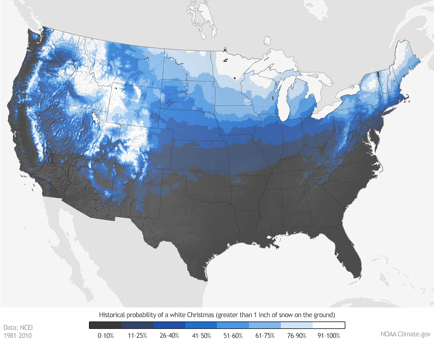
The map at the top of the page shows the historical probability (over the last 30 years) of having at least one inch of snow on the ground on December 25th. For an interactive map that lets you zoom and click on various climate sites, click here. In fact, check out this article from NOAA, with many more links and even a spreadsheet with Christmas snow probabilities.
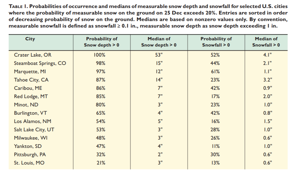
If you want a near guarantee for a white Christmas, you should probably head to the Upper Midwest, Northern New England, the Rocky Mountains, or the Sierra/Cascades. This is historically where chances are greater than 90 percent. The table below may give you a good idea of where to book next year's holiday excursion should you really want to see snow on Christmas day.
 Still, the map at the top only shows historical probability and does not account for the major swings in weather patterns each year that, with the right timing and ingredients, can bring snow to nearly anywhere in the lower 48.
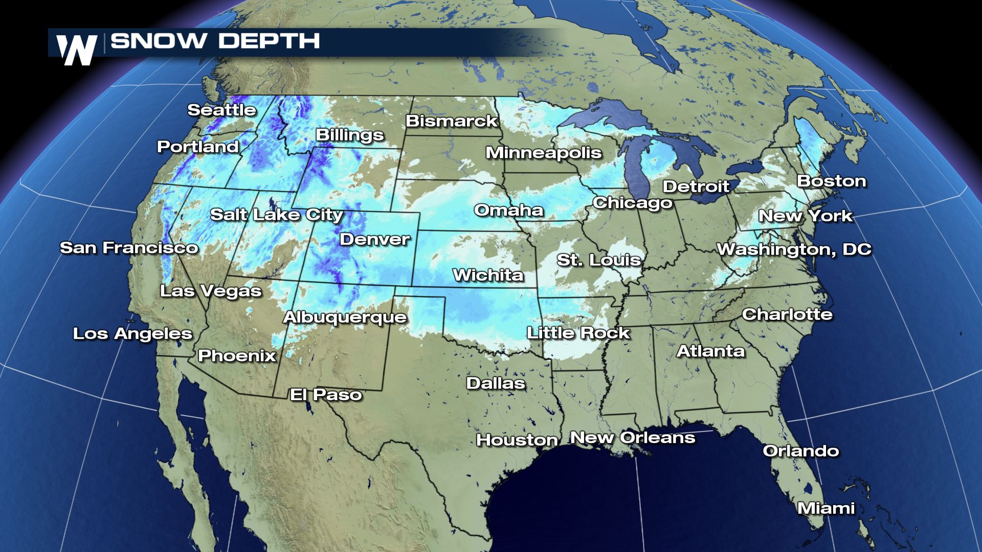
In fact, at the time this article is being published, there's over an inch of snow on the ground across a large portion of the Southern Plains (see snow depth map below), including Northern Texas where probabilities are climatologically low in late December. That snow will likely be gone by the 25th, while areas in darker blue (mainly higher elevations) will have better luck holding onto their current powder.
Still, the map at the top only shows historical probability and does not account for the major swings in weather patterns each year that, with the right timing and ingredients, can bring snow to nearly anywhere in the lower 48.
In fact, at the time this article is being published, there's over an inch of snow on the ground across a large portion of the Southern Plains (see snow depth map below), including Northern Texas where probabilities are climatologically low in late December. That snow will likely be gone by the 25th, while areas in darker blue (mainly higher elevations) will have better luck holding onto their current powder.
 So, how is this year shaping up? Lets take a look at the latest outlooks from the Climate Prediction Center.
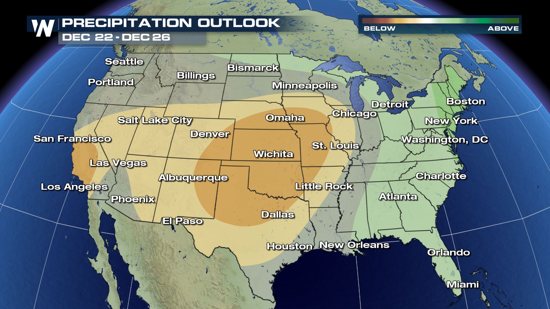
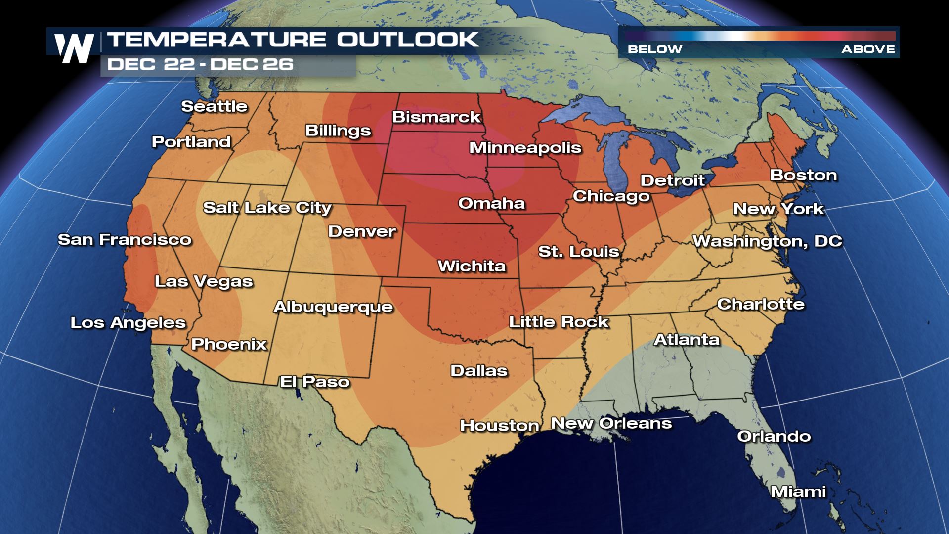 The potential impacts from that trough are more evident in the CPC's precipitation outlook for the 22nd to the 26th. Most of the country's midsection and the Southwest look to record lower than average precipitation, while chances look decent for rain and/or snow across the East. This would favor snow chances in some of our more climatologically inclined locations across the Upper Midwest, through the Great Lakes, and in the higher elevations of the Northeast. Of course, there's a lot of time for forecast details to be figured out so don't lose hope if you're dreaming of snow on Christmas Day.
 We can't forget that although air travel has been down this year, many will still travel for the holidays and may have to deal with messy roads or delays in the airports because of the aforementioned trough.
 Yet again, most of the West looks to stay drier than average while the East and Gulf Coast will have a shot at seeing near normal precipitation. Since the 8-14 day outlook has greater uncertainty than the 6-10 day period, this is one to watch for bigger changes that could slow down any traveling or your daily routine.
 Be sure to stay up-to-date with us on the forecast around the holidays by watching our broadcasts and checking back with us here.
Still, the map at the top only shows historical probability and does not account for the major swings in weather patterns each year that, with the right timing and ingredients, can bring snow to nearly anywhere in the lower 48.
In fact, at the time this article is being published, there's over an inch of snow on the ground across a large portion of the Southern Plains (see snow depth map below), including Northern Texas where probabilities are climatologically low in late December. That snow will likely be gone by the 25th, while areas in darker blue (mainly higher elevations) will have better luck holding onto their current powder.
So, how is this year shaping up? Lets take a look at the latest outlooks from the Climate Prediction Center.
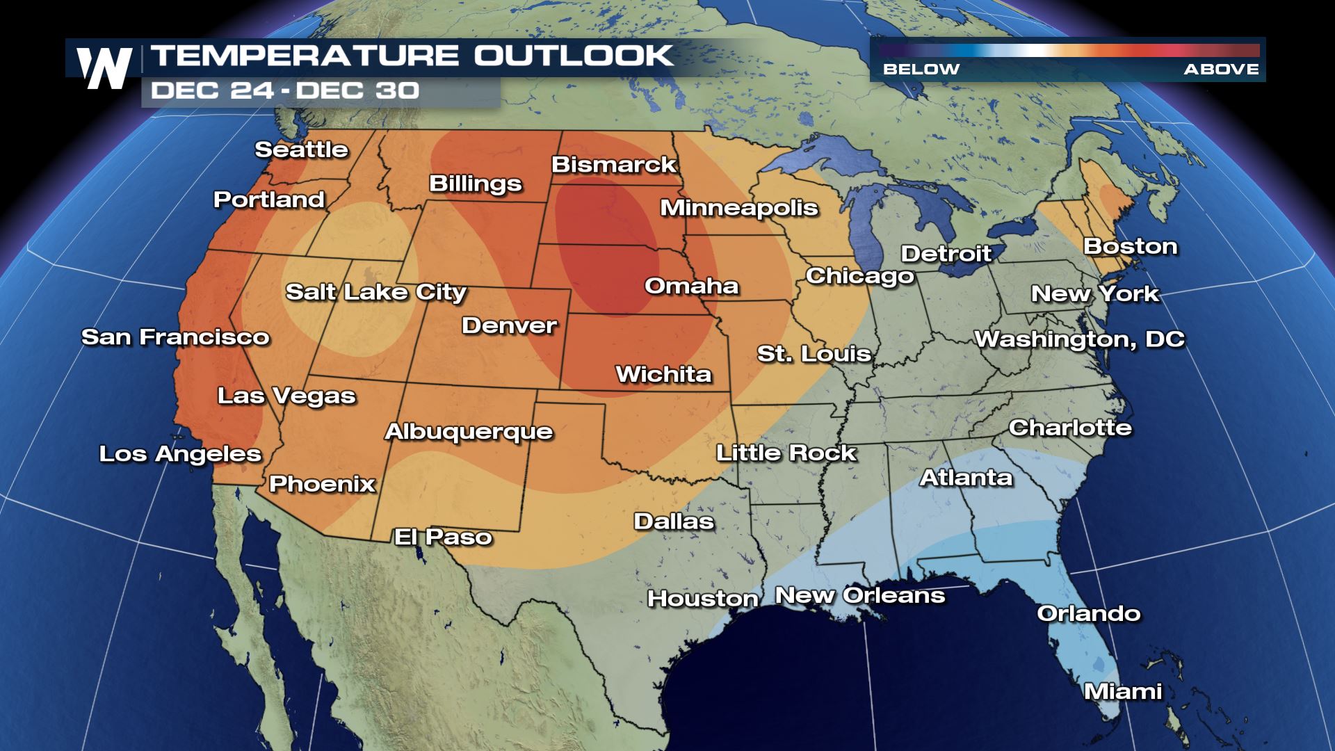
Warmer Than Average For Most
In the days leading up to Christmas, the Climate Prediction Center's 6-10 day outlook favors winter warmth for much of the Midwest and, in fact, for most of the lower 48. Don't let this snapshot get your snowy hopes down though, this is an average over those four days and most global models show a fast moving trough swinging through the Great Lakes and Eastern third of the country from Thursday (the 24th) into the weekend. That trough is partly responsible for the lack of "above average" probability in the Southeast.
The potential impacts from that trough are more evident in the CPC's precipitation outlook for the 22nd to the 26th. Most of the country's midsection and the Southwest look to record lower than average precipitation, while chances look decent for rain and/or snow across the East. This would favor snow chances in some of our more climatologically inclined locations across the Upper Midwest, through the Great Lakes, and in the higher elevations of the Northeast. Of course, there's a lot of time for forecast details to be figured out so don't lose hope if you're dreaming of snow on Christmas Day.
We can't forget that although air travel has been down this year, many will still travel for the holidays and may have to deal with messy roads or delays in the airports because of the aforementioned trough.
Staying Warm and Dry Out West
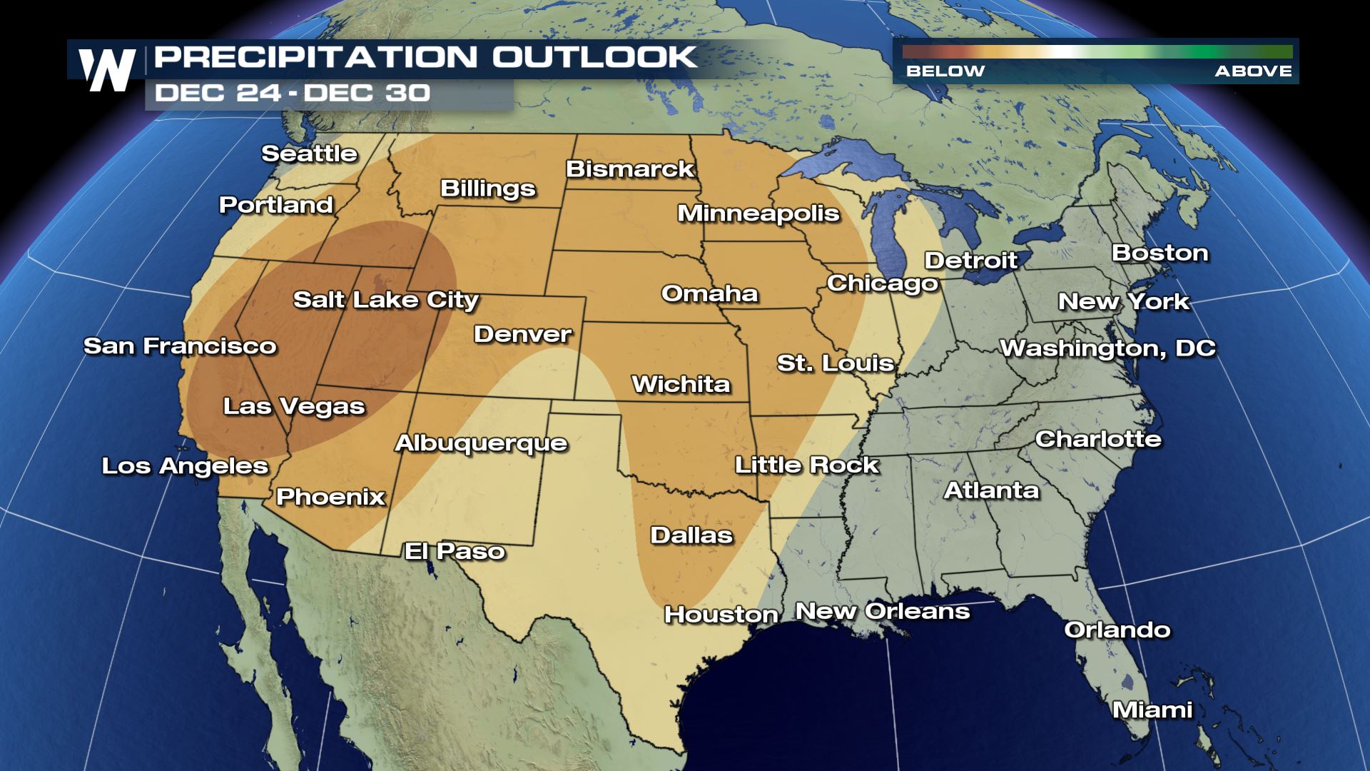
How about the days after Christmas leading up to the new year? Once again, the CPC favors warmer than average temperatures out west, with potential for cooler than average temperatures in the Southeast. This doesn't mean much when we're trying to gauge how the pattern will potentially impact travel however, so let's look at the precipitation outlook.
Yet again, most of the West looks to stay drier than average while the East and Gulf Coast will have a shot at seeing near normal precipitation. Since the 8-14 day outlook has greater uncertainty than the 6-10 day period, this is one to watch for bigger changes that could slow down any traveling or your daily routine.
Be sure to stay up-to-date with us on the forecast around the holidays by watching our broadcasts and checking back with us here.All Weather News
More
Massive Fires Burn in the Four Corners
The Aspen Acres fire burning in Southern Colo
1 Jul 2026 7:25 PM

Storms Spark up in the Northeast Ahead of Heatwave
Severe storms will be possible as we head tow
1 Jul 2026 7:25 PM

Dangerous Stretch of Heat Leads Us to the 4th
The hottest temperatures of the year are loom
1 Jul 2026 7:20 PM

Severe Storms Keep Northern U.S. Active
Winds hit 85 mph in Nebraska in the last 24 h
1 Jul 2026 7:10 PM

Slow-Moving Front No Longer Expected to Develop Tropically, Monitoring Eastern Pacific
Early in the season, we watch closer to the c
30 Jun 2026 9:00 PM

'MCS' Season Brings Severe and Flooding Threats Across the Southeast
As Summer settles in across the Central U.S.,
28 Jun 2026 2:10 AM

Severe Threat Tracks into the Northeast Friday
Another day, another Illinois tornado. That's
26 Jun 2026 2:25 AM