Hundreds of Thousands of Acres Spared So Far This Year in California
Top Stories
16 Aug 2019 7:29 AM
https://youtu.be/Lg9ainul0qk
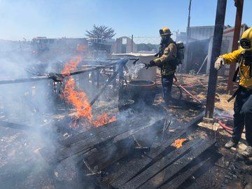
The wildfire season of 2017 was heartbreaking for California, followed by another record-setting 2018 season.
 It was also in 2018 that we saw the largest, most destructive, and deadliest fires in recorded history burn across the northern part of the state.
https://twitter.com/i/status/1063630324771389440
So far in 2019, it has been a different story.
From January 1 through August 1, there have been just under 3,000 wildfires across the Golden State.
This is compared to nearly 3,700 at the same time last year, sparing hundreds of thousands of acres.
It was also in 2018 that we saw the largest, most destructive, and deadliest fires in recorded history burn across the northern part of the state.
https://twitter.com/i/status/1063630324771389440
So far in 2019, it has been a different story.
From January 1 through August 1, there have been just under 3,000 wildfires across the Golden State.
This is compared to nearly 3,700 at the same time last year, sparing hundreds of thousands of acres.
"We respond to hundreds of fires on a daily basis, which we consider our initial attack fire," said Mike Mohler, Cal Fire Deputy Director of Communications. "95% of those at 10 acres or less. It’s that 5% that turn into those really large fires so really Mother Nature has been the big key factor in keeping the acreage down this year."
The reason? Above average precipitation during the winter.
"We started out this last winter in pretty good shape as far as precipitation amounts and recovery with vegetation," said Eric Boldt, Warning Coordination Meteorologist for the National Weather Service Los Angeles/Oxnard.
"In the mountains, we had record snow pack especially during the month of February, and that really resulted in filling the reservoirs and replenishing a lot of the water we need for the rest of the season.
https://twitter.com/i/status/1098714916704284672
Drought conditions have also significantly improved since last year, and you can see the substantial change in the Drought Monitor from the beginning of August in 2018 to 2019.
This is all thanks to effects from a weak El Nino.
"The pattern persists with this onshore flow keeping us rather moist, especially the humidities stay up a little more closer to the ocean and we have the onshore flow keeping the cooler temperatures in there," Boldt said.
"Even the heat waves have been a little bit more to our east, we’ve not really had much of a monsoon season here in California."
https://twitter.com/i/status/1162127954643603456
And less extreme wind events have allowed firefighters to get their job done in a shorter period of time.
"When we have a wind driven fire, that’s not something we just stand out in front of and stop the head," Mohler said. "We have to flank that fire so where we’re seeing less wind events, more precipitation, slower fire growth, and we’re able to get a handle on them much quicker."
https://twitter.com/i/status/1160292881929605120
FIRE SAFETY INFORMATION
But while it has been much quieter so far, you should still be prepared and on alert for what’s to come this fall.
"The offshore dry wind scenarios are yet to come," Boldt said. "And we don’t expect that to really get going until October or November. It’s fairly far away to make an accurate forecast as above or below normal, but we’d probably be leaning toward a little bit above normal overall and we’re crossing our fingers that we’ll get back to back wet years and that’s what we really need to happen."
For WeatherNation, I’m Meteorologist Garofalo
It was also in 2018 that we saw the largest, most destructive, and deadliest fires in recorded history burn across the northern part of the state.
https://twitter.com/i/status/1063630324771389440
So far in 2019, it has been a different story.
From January 1 through August 1, there have been just under 3,000 wildfires across the Golden State.
This is compared to nearly 3,700 at the same time last year, sparing hundreds of thousands of acres.
Number of Fires and Acres:
(SOURCE: Cal Fire)| Interval | Fires | Acres |
| January 1, 2019 through August 4, 2019 | 2,971 | 22,949 |
| January 1, 2018 through August 4, 2018 | 3,661 | 615,771 |
| 5-Year Average (same interval) | 3,572 | 245,850 |
| 2019 Combined YTD (CALFIRE & US Forest Service) | 3,487 | 45,364 |
All Weather News
More
Wildfire Outbreak in the Pacific Northwest
SPOKANE, WA - On Saturday, August 1st, the Ol
2 Aug 2026 7:20 PM

More Storms for the East Through Monday
A low-pressure system that moved through the
2 Aug 2026 7:20 PM


After Reaching Category 5, Genevieve Weakens in the Pacific
PacificGenevieve formed on last Friday south
2 Aug 2026 6:25 PM

Flooding, Severe Storms Target the Midwest Again
After an active week of storms across the nor
1 Aug 2026 1:40 AM

Flooding Risk Increases as Heavy Rain Targets the Tri-State Area
Tuesday, heavy rainfall moved across the Nort
30 Jul 2026 12:25 AM

Severe Weather: Energy From the Midwest Now in the Southeast
UPPER MIDWEST - Through Monday, dangerous tor
29 Jul 2026 10:30 PM