Hurricane Forecast Reminder: Don't Focus on Single Model Updates
Special Stories
18 Jun 2018 7:32 AM
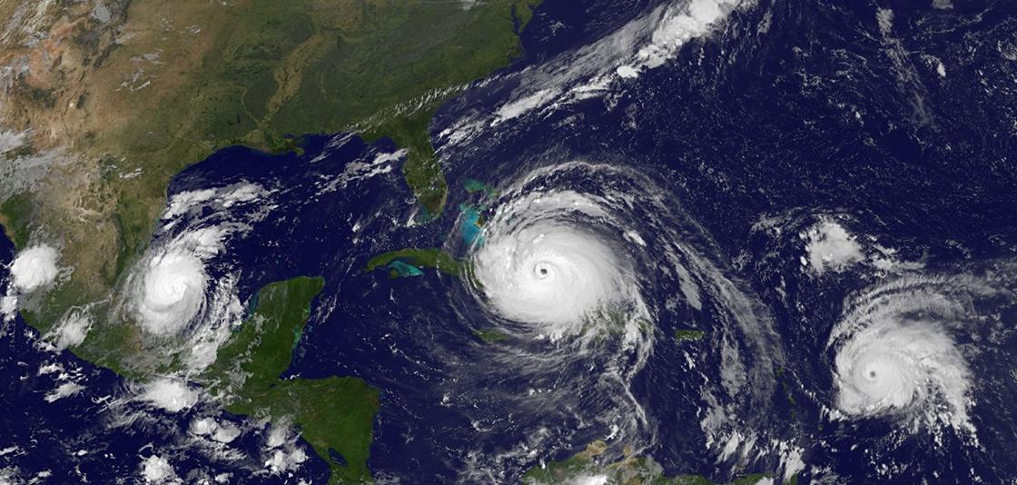
[GOES 16 full disk image of hurricanes Katia, Irma and Jose captured September 8, 2017. From NOAA]
From NWS
The sultry summer months along the Gulf Coast and East Coast are a time of volatile weather as warm ocean water fuels storms, some just bringing rain and some growing into fierce tropical storms and hurricanes. The World Meteorological Organization rotates an alphabetical naming system every year to simplify references to tropical storms and hurricanes, but selecting a name is perhaps the simplest task surrounding them, while the more complex challenge lies in predicting where they will go.
The oftentimes destructive nature of tropical storms and hurricanes makes it paramount for the National Weather Service’s National Hurricane Center (NHC) to accurately predict the track, intensity, and size of tropical storms and hurricanes, and provide information related to various hazards, such as storm surge, wind, and heavy rainfall. NHC forecasters rely on numerical weather prediction models run on advanced supercomputers to develop their forecasts.
 Dr. Louis Uccellini, director of the National Weather Service, explains that “numerical modeling itself - the introduction of those models, the continued improvements, the ability to run them in real time - has fundamentally revolutionized weather forecasting and has allowed us to make accurate hurricane forecasts up to five days in advance.”
NHC forecasters don’t rely on one single run of a specific computer model to create a forecast. Rather, they’ve found that the best predictions of a hurricane’s future track and intensity are formed based on a multi-model ensemble - grouping several models together. Multi-model ensembles, also called the consensus approach by forecasters, significantly increase forecast accuracy over any individual model by canceling out biases found in individual models. Think of a modeling ensemble as you would a musical ensemble: while each individual instrument is vital, it is the unified whole that accomplishes harmony.
Dr. Louis Uccellini, director of the National Weather Service, explains that “numerical modeling itself - the introduction of those models, the continued improvements, the ability to run them in real time - has fundamentally revolutionized weather forecasting and has allowed us to make accurate hurricane forecasts up to five days in advance.”
NHC forecasters don’t rely on one single run of a specific computer model to create a forecast. Rather, they’ve found that the best predictions of a hurricane’s future track and intensity are formed based on a multi-model ensemble - grouping several models together. Multi-model ensembles, also called the consensus approach by forecasters, significantly increase forecast accuracy over any individual model by canceling out biases found in individual models. Think of a modeling ensemble as you would a musical ensemble: while each individual instrument is vital, it is the unified whole that accomplishes harmony.
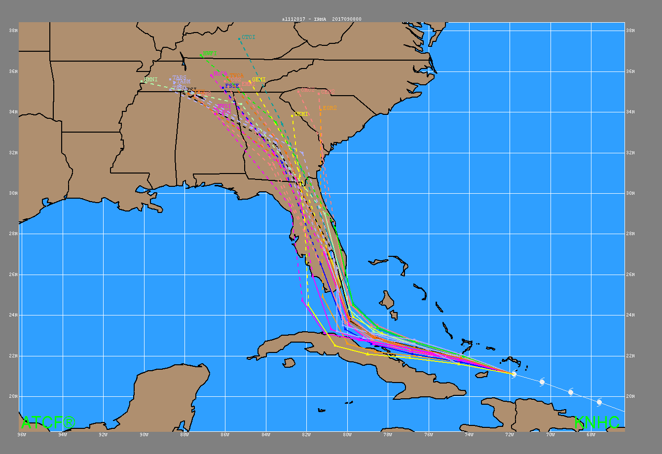 [Track model plot, often called spaghetti model plot, from Hurricane Irma from 8 p.m. EDT September 9, 2017.]
When forecasting Atlantic hurricanes, the NHC creates a “consensus” forecast from five unique models - each with different initial conditions, physics, and model resolutions - to be used as guidance when making the official forecast.
Unfortunately, when a potential hurricane is inciting worry and stress, it is easy to mistake a prediction from one model for a final forecast. On this topic, Dr. Uccellini wants to impress upon the public that “we have a partnership with the international community, we exchange our models, we exchange our model output, we exchange our ensembles. And it’s all of these model runs that our forecasters are using to develop what they believe will be the best forecast, with a higher level of certainty, that allows us to then sit down with the emergency management community and give them not only the options, but what we believe is going to be the best option.”
Edited for WeatherNation by Meteorologist Mace Michaels
[Track model plot, often called spaghetti model plot, from Hurricane Irma from 8 p.m. EDT September 9, 2017.]
When forecasting Atlantic hurricanes, the NHC creates a “consensus” forecast from five unique models - each with different initial conditions, physics, and model resolutions - to be used as guidance when making the official forecast.
Unfortunately, when a potential hurricane is inciting worry and stress, it is easy to mistake a prediction from one model for a final forecast. On this topic, Dr. Uccellini wants to impress upon the public that “we have a partnership with the international community, we exchange our models, we exchange our model output, we exchange our ensembles. And it’s all of these model runs that our forecasters are using to develop what they believe will be the best forecast, with a higher level of certainty, that allows us to then sit down with the emergency management community and give them not only the options, but what we believe is going to be the best option.”
Edited for WeatherNation by Meteorologist Mace Michaels
Dr. Louis Uccellini, director of the National Weather Service, explains that “numerical modeling itself - the introduction of those models, the continued improvements, the ability to run them in real time - has fundamentally revolutionized weather forecasting and has allowed us to make accurate hurricane forecasts up to five days in advance.”
NHC forecasters don’t rely on one single run of a specific computer model to create a forecast. Rather, they’ve found that the best predictions of a hurricane’s future track and intensity are formed based on a multi-model ensemble - grouping several models together. Multi-model ensembles, also called the consensus approach by forecasters, significantly increase forecast accuracy over any individual model by canceling out biases found in individual models. Think of a modeling ensemble as you would a musical ensemble: while each individual instrument is vital, it is the unified whole that accomplishes harmony.
[Track model plot, often called spaghetti model plot, from Hurricane Irma from 8 p.m. EDT September 9, 2017.]
When forecasting Atlantic hurricanes, the NHC creates a “consensus” forecast from five unique models - each with different initial conditions, physics, and model resolutions - to be used as guidance when making the official forecast.
Unfortunately, when a potential hurricane is inciting worry and stress, it is easy to mistake a prediction from one model for a final forecast. On this topic, Dr. Uccellini wants to impress upon the public that “we have a partnership with the international community, we exchange our models, we exchange our model output, we exchange our ensembles. And it’s all of these model runs that our forecasters are using to develop what they believe will be the best forecast, with a higher level of certainty, that allows us to then sit down with the emergency management community and give them not only the options, but what we believe is going to be the best option.”
Edited for WeatherNation by Meteorologist Mace MichaelsAll Weather News
More
More Storms for the East Through Monday
A low-pressure system that moved through the
2 Aug 2026 10:40 PM

Wildfire Outbreak in the Pacific Northwest
SPOKANE, WA - On Saturday, August 1st, the Ol
2 Aug 2026 10:35 PM


After Reaching Category 5, Genevieve Weakens in the Pacific
PacificGenevieve formed on last Friday south
2 Aug 2026 6:25 PM

Flooding, Severe Storms Target the Midwest Again
After an active week of storms across the nor
1 Aug 2026 1:40 AM

Flooding Risk Increases as Heavy Rain Targets the Tri-State Area
Tuesday, heavy rainfall moved across the Nort
30 Jul 2026 12:25 AM

Severe Weather: Energy From the Midwest Now in the Southeast
UPPER MIDWEST - Through Monday, dangerous tor
29 Jul 2026 10:30 PM