Hurricane Hunters Could Investigate Storm Friday
Special Stories
24 May 2018 8:49 PM
If necessary, the National Hurricane Center (NHC) will send a crew of meteorologists and scientists into the tropical wave (Invest 90L) on Friday.
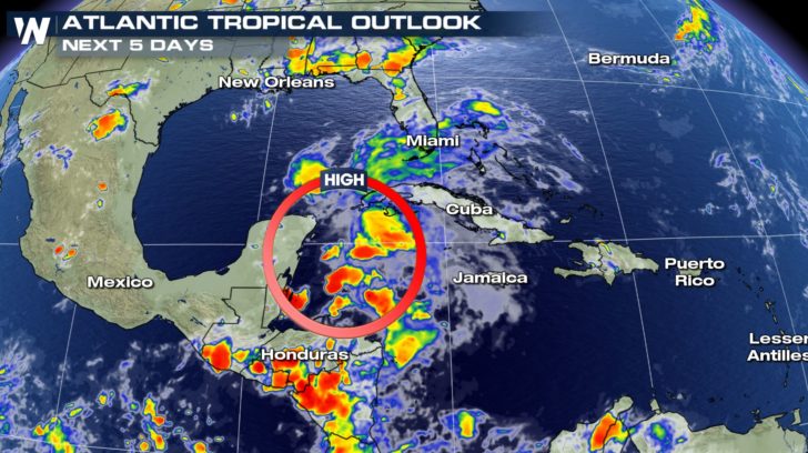 The tropical weather outlook through Monday, May 27 shows a high chance of tropical development in the eastern Gulf of Mexico.
NHC usually plans a reconnaissance flight to get that incredibly-vital information of what's exactly happening inside a storm, or in this case, a tropical wave. Pilots fly into the weather system, conduct a "crisscross" pattern, try to find a center of circulation, collect observations of highest wind speed and lowest barometric pressure, and many other tests.
Related story: The Importance of Hurricane Hunters
In scenarios like this, the meteorologists will be looking to see if a center of circulation has formed within Invest 90L and if winds are high enough for tropical storm status (39 mph or greater).
The tropical weather outlook through Monday, May 27 shows a high chance of tropical development in the eastern Gulf of Mexico.
NHC usually plans a reconnaissance flight to get that incredibly-vital information of what's exactly happening inside a storm, or in this case, a tropical wave. Pilots fly into the weather system, conduct a "crisscross" pattern, try to find a center of circulation, collect observations of highest wind speed and lowest barometric pressure, and many other tests.
Related story: The Importance of Hurricane Hunters
In scenarios like this, the meteorologists will be looking to see if a center of circulation has formed within Invest 90L and if winds are high enough for tropical storm status (39 mph or greater).
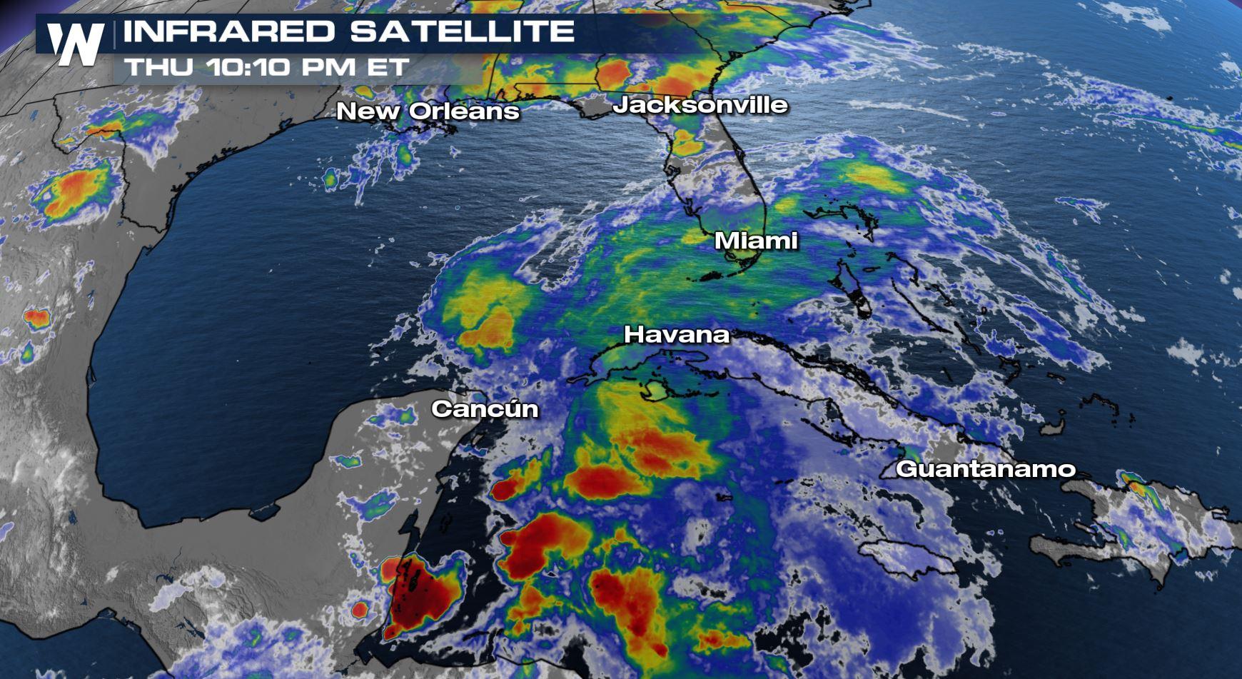
 Satellite imagery over Invest 90L Thursday evening showed the system still looked disorganized.
Related story: The View From Inside a Hurricane Flight
Here's the tentative schedule for NHC flights and the possibility of formation:
Satellite imagery over Invest 90L Thursday evening showed the system still looked disorganized.
Related story: The View From Inside a Hurricane Flight
Here's the tentative schedule for NHC flights and the possibility of formation:
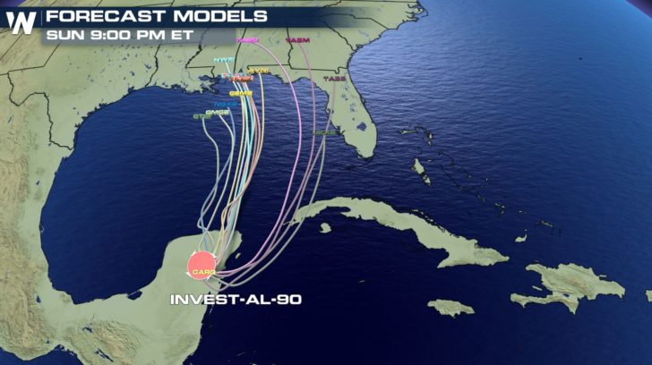 Forecast weather models each showing the projected storm center through Sunday evening.
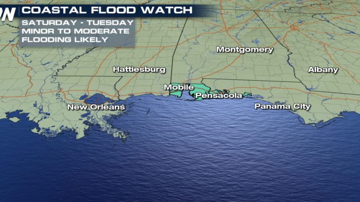
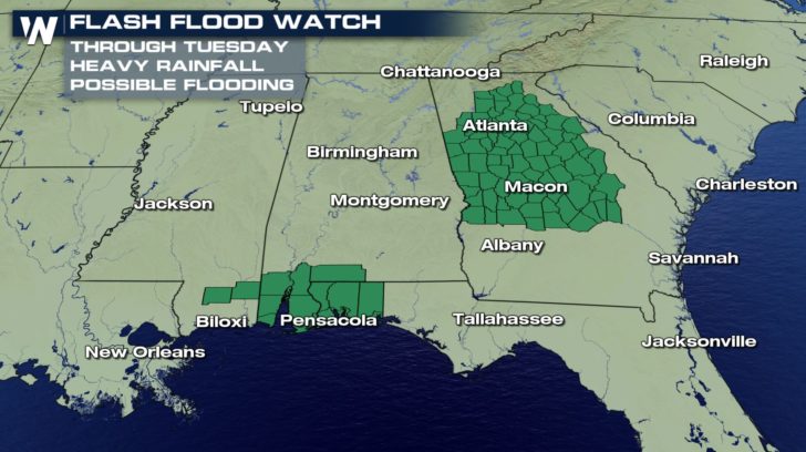
It is important not to focus solely on the track, but the widespread impacts. In this case, flooding appears to be the biggest hazard to the Gulf Coast states.
Forecast weather models each showing the projected storm center through Sunday evening.
It is important not to focus solely on the track, but the widespread impacts. In this case, flooding appears to be the biggest hazard to the Gulf Coast states.
 Stay with WeatherNation for the very latest.
For WeatherNation, Meteorologist Steve Glazier
Stay with WeatherNation for the very latest.
For WeatherNation, Meteorologist Steve Glazier
The tropical weather outlook through Monday, May 27 shows a high chance of tropical development in the eastern Gulf of Mexico.
NHC usually plans a reconnaissance flight to get that incredibly-vital information of what's exactly happening inside a storm, or in this case, a tropical wave. Pilots fly into the weather system, conduct a "crisscross" pattern, try to find a center of circulation, collect observations of highest wind speed and lowest barometric pressure, and many other tests.
Related story: The Importance of Hurricane Hunters
In scenarios like this, the meteorologists will be looking to see if a center of circulation has formed within Invest 90L and if winds are high enough for tropical storm status (39 mph or greater).
Satellite imagery over Invest 90L Thursday evening showed the system still looked disorganized.
Related story: The View From Inside a Hurricane Flight
Here's the tentative schedule for NHC flights and the possibility of formation:
- Friday at 2 a.m. ET: Tropical weather outlook is released
- Friday at 8 a.m. ET: Tropical weather outlook is released
- Friday around 1 p.m. ET Reconnaissance flight takes place
Forecast weather models each showing the projected storm center through Sunday evening.
It is important not to focus solely on the track, but the widespread impacts. In this case, flooding appears to be the biggest hazard to the Gulf Coast states.
Stay with WeatherNation for the very latest.
For WeatherNation, Meteorologist Steve GlazierAll Weather News
More
Fronts Continue To Spark Severe Weather Across the Plains
A cold front that brought record lows to the
18 Jul 2025 10:40 PM

Extreme Heat Impacts for the East Coast & South
Extreme heat continues to impact several area
18 Jul 2025 10:05 PM

Flooding Threat Remains Elevated in the East
A cold front pushing through the Eastern Seab
18 Jul 2025 9:10 PM

EF-2 Firenado from the Deer Creek Fire in Utah
A fire tornado was spotted near La Sal, Utah
18 Jul 2025 7:30 AM

Tropical System Brings Flood Risk to the Central Gulf
Time has run out for notable tropical develop
18 Jul 2025 3:05 AM

Heavy Rain, Flooding Threat Returns to Florida
Keep the rain boots handy in Florida - heavy
13 Jul 2025 12:50 PM

Severe Storm Risk Pushes into the Great Lakes, Ohio Valley
Friday was another busy day with severe weath
12 Jul 2025 8:00 PM