Hurricane Michael Before and After Damage Assessment Imagery
Special Stories
15 Oct 2018 8:59 AM
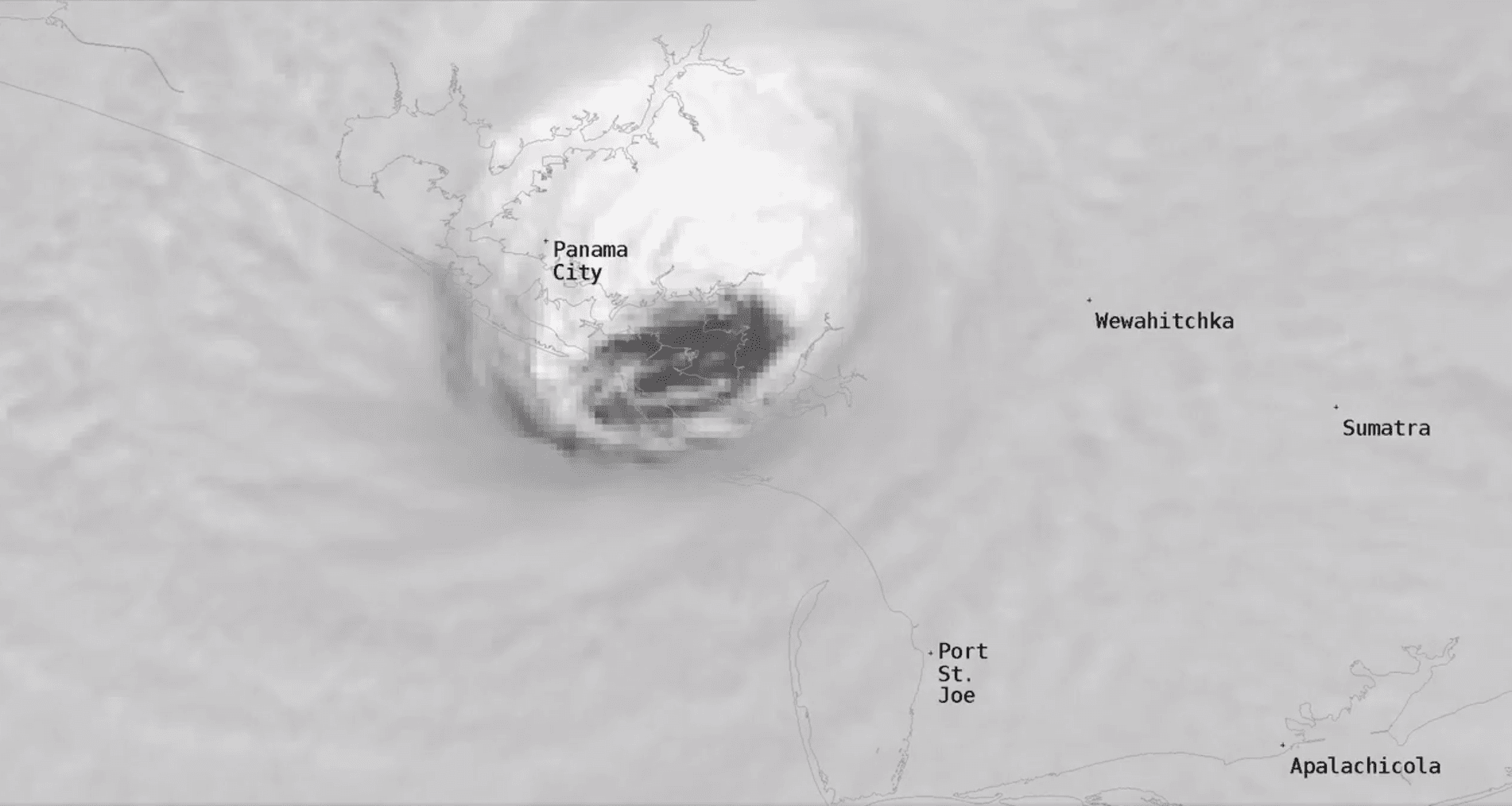
[Close-up satellite image of the eye of Hurricane Michael as it made landfall at Mexico Beach, Florida last Wednesday afternoon, October 10th.]
[NOAA] Last Thursday, October 11, the National Geodetic Survey (NGS) began collecting damage assessment imagery in the aftermath of Hurricane Michael. Weather permitting, aerial imagery will be collected in specific areas identified by NOAA in coordination with FEMA and other state and federal partners. During the mission, NGS will fly two missions a day. Images will be updated every 12 hours, which includes flight and processing time. Collected images are available to view online via the NGS aerial imagery viewer.
A team of NOAA aviators and sensor operators are capturing the images using specialized remote-sensing cameras aboard NOAA Office of Marine and Aviation Operations' King Air aircraft flying above the area at an altitude between 500 and 1500 meters (about 1,600 to 5,000 feet).
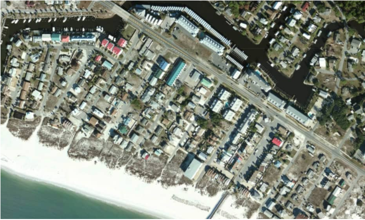
 [Mexico Beach, Florida. Top image is before Hurricane Michael landfall, provided by Mapbox, Digital Globe, and OpenStreetMap. Bottom image is after Michael, from NOAA's National Geodetic Survey.]
NOAA's aerial imagery aids safe navigation and captures damage to coastal areas caused by a storm. Aerial imagery is a crucial tool to determine the extent of the damage inflicted by flooding, and to compare baseline coastal areas to assess the damage to major ports and waterways, coastlines, critical infrastructure, and coastal communities. This imagery provides a cost-effective way to better understand the damage sustained to both property and the environment.
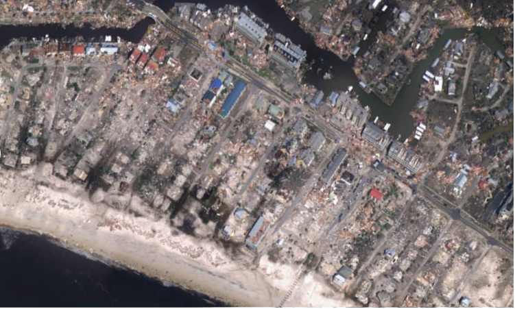
[Mexico Beach, Florida. Top image is before Hurricane Michael landfall, provided by Mapbox, Digital Globe, and OpenStreetMap. Bottom image is after Michael, from NOAA's National Geodetic Survey.]
NOAA's aerial imagery aids safe navigation and captures damage to coastal areas caused by a storm. Aerial imagery is a crucial tool to determine the extent of the damage inflicted by flooding, and to compare baseline coastal areas to assess the damage to major ports and waterways, coastlines, critical infrastructure, and coastal communities. This imagery provides a cost-effective way to better understand the damage sustained to both property and the environment.
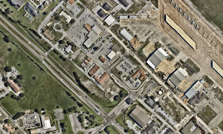
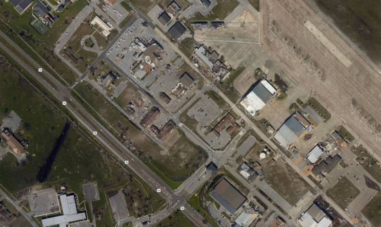 [Tyndall Air Force Base, Florida. Top image is before Hurricane Michael landfall, provided by Mapbox, Digital Globe, and OpenStreetMap. Bottom image is after Michael, from NOAA's National Geodetic Survey.]
Edited for WeatherNation by Meteorologist Mace Michaels
[Tyndall Air Force Base, Florida. Top image is before Hurricane Michael landfall, provided by Mapbox, Digital Globe, and OpenStreetMap. Bottom image is after Michael, from NOAA's National Geodetic Survey.]
Edited for WeatherNation by Meteorologist Mace Michaels
[Mexico Beach, Florida. Top image is before Hurricane Michael landfall, provided by Mapbox, Digital Globe, and OpenStreetMap. Bottom image is after Michael, from NOAA's National Geodetic Survey.]
NOAA's aerial imagery aids safe navigation and captures damage to coastal areas caused by a storm. Aerial imagery is a crucial tool to determine the extent of the damage inflicted by flooding, and to compare baseline coastal areas to assess the damage to major ports and waterways, coastlines, critical infrastructure, and coastal communities. This imagery provides a cost-effective way to better understand the damage sustained to both property and the environment.
Available Imagery
View NOAA Emergency Response Imagery collected on the following days:- October 11: Mobile Bay to St. George Island, Florida, and over Panama City, Florida.
- October 12: Major transportation routes along the path of hurricane force winds; several localities in Northern Florida and Southern Georgia.
- October 13: Outer coast from St. George Island east to Cedar Key, Florida; Bonifay, Chipley, and the Gulf Intracoastal Waterway from West Bay to Point Washington, Florida.
[Tyndall Air Force Base, Florida. Top image is before Hurricane Michael landfall, provided by Mapbox, Digital Globe, and OpenStreetMap. Bottom image is after Michael, from NOAA's National Geodetic Survey.]
Edited for WeatherNation by Meteorologist Mace Michaels
All Weather News
More
Fronts Continue To Spark Severe Weather Across the Plains
A cold front that brought record lows to the
18 Jul 2025 10:40 PM

Extreme Heat Impacts for the East Coast & South
Extreme heat continues to impact several area
18 Jul 2025 10:05 PM

Flooding Threat Remains Elevated in the East
A cold front pushing through the Eastern Seab
18 Jul 2025 9:10 PM

EF-2 Firenado from the Deer Creek Fire in Utah
A fire tornado was spotted near La Sal, Utah
18 Jul 2025 7:30 AM

Tropical System Brings Flood Risk to the Central Gulf
Time has run out for notable tropical develop
18 Jul 2025 3:05 AM

Heavy Rain, Flooding Threat Returns to Florida
Keep the rain boots handy in Florida - heavy
13 Jul 2025 12:50 PM

Severe Storm Risk Pushes into the Great Lakes, Ohio Valley
Friday was another busy day with severe weath
12 Jul 2025 8:00 PM