Hurricanes: Common Misperceptions Heard from the National Hurricane Center
Special Stories
6 Sep 2018 9:09 AM
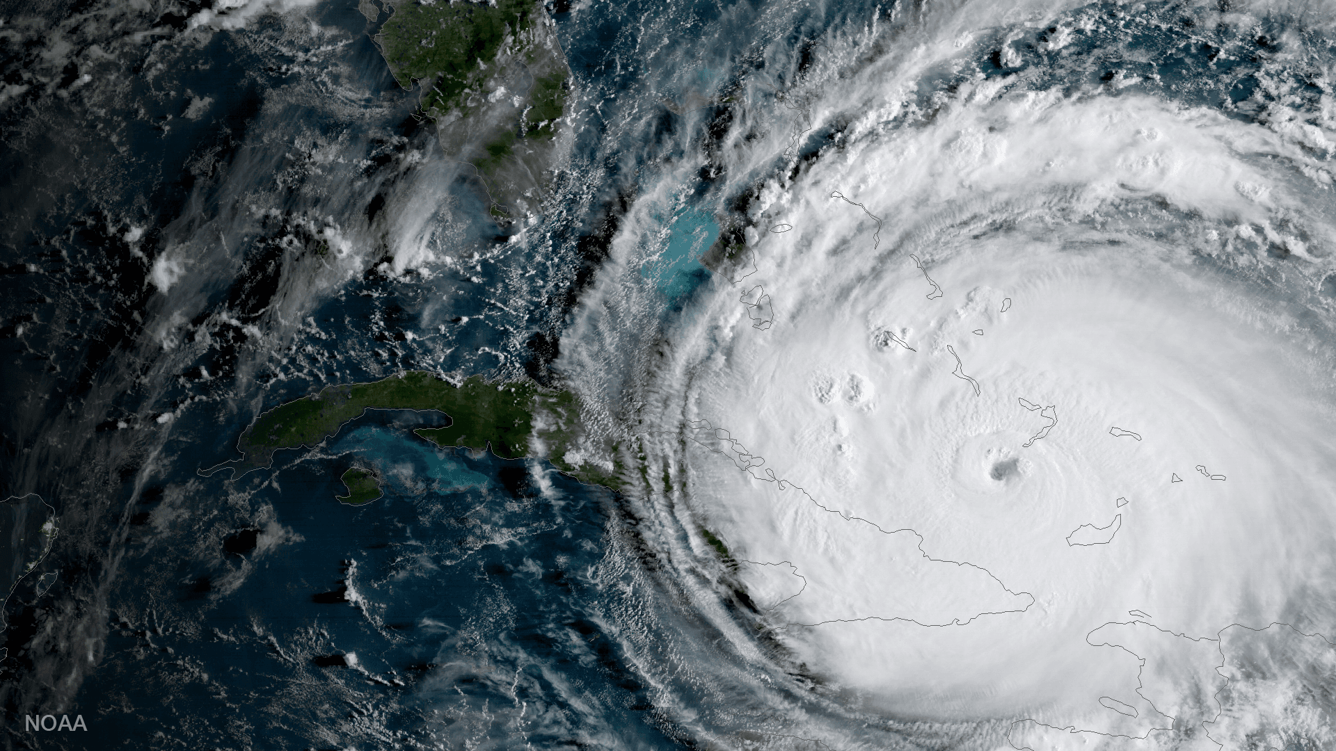
[Satellite photo of major Hurricane Irma on Sept 8, 2017. Credit: NOAA]
From NOAA
Millions of people were affected by hurricanes last year. Their perceptions have now been reset, but some don’t line up with reality. Social science may be the answer to fixing it.
When a hurricane is approaching, many people prepare based on previous experience, but they’re not always right. As we approach the peak of hurricane season, here is a sampling of common misperceptions from Dennis Feltgen of the National Hurricane Center:
“I live outside of the cone, so I am safe from feeling the effects.”
The cone has nothing to do with impacts, only the average track error of the past five years. 2017’s Irma went up Florida’s west coast, but its wind field grew in size and pushed storm surge onto Florida’s east coast.
“It’s never flooded here before.”
It’s not easy to picture 60 inches of rain, but it was one of the biggest stories of Harvey. There’s no historical record of that amount, so it’s difficult to imagine what it will do.
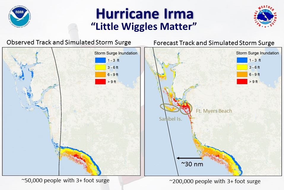 [Storm surge inundation (feet above ground level) based on Irma’s actual track versus forecasted track. The wiggle to the east spared the coastline from Naples northward to the Cape Coral area from storm surge inundation greater than 9 feet above ground level. Image Credit: NOAA]
“I got hit last year and it was a one hundred year storm, so I’m in good shape for the next one hundred years.”
All a hundred year storm means is that you have a one percent chance of it happening to you every single year. That’s the same as a 25 percent chance of flooding in a typical 30-year mortgage. You can get hit in back to back years or even in the same year.
“A very slight wiggle in the track doesn't matter.”
That could be true over the middle of the ocean, but not for land. Hurricane Irma proved that. Its wiggle of 30 miles along Florida southwest coast meant the difference between getting only a few feet of storm surge versus 9 feet.
“We went through a Cat 4 and nothing bad happened”
Many people in Key West will tell you Irma was a Cat 4 there. The reality is they only got Cat 1 winds. You had to go 20 to 30 miles away to find the Cat 4 winds. The reality is that you’ve got to understand exactly what you went through and that you may not have seen the strongest part of that storm.
How do we line up perception with reality? The answer lies in social science. A project will soon begin at NOAA’s National Hurricane Center to find ways to better communicate the risk from the hurricane hazards, find out how people are interpreting our products and to make sure everything is actionable. We have to plan for what COULD happen, not what has happened in the past. It’s a life and death proposition.
Edited for WeatherNation by Meteorologist Mace Michaels
[Storm surge inundation (feet above ground level) based on Irma’s actual track versus forecasted track. The wiggle to the east spared the coastline from Naples northward to the Cape Coral area from storm surge inundation greater than 9 feet above ground level. Image Credit: NOAA]
“I got hit last year and it was a one hundred year storm, so I’m in good shape for the next one hundred years.”
All a hundred year storm means is that you have a one percent chance of it happening to you every single year. That’s the same as a 25 percent chance of flooding in a typical 30-year mortgage. You can get hit in back to back years or even in the same year.
“A very slight wiggle in the track doesn't matter.”
That could be true over the middle of the ocean, but not for land. Hurricane Irma proved that. Its wiggle of 30 miles along Florida southwest coast meant the difference between getting only a few feet of storm surge versus 9 feet.
“We went through a Cat 4 and nothing bad happened”
Many people in Key West will tell you Irma was a Cat 4 there. The reality is they only got Cat 1 winds. You had to go 20 to 30 miles away to find the Cat 4 winds. The reality is that you’ve got to understand exactly what you went through and that you may not have seen the strongest part of that storm.
How do we line up perception with reality? The answer lies in social science. A project will soon begin at NOAA’s National Hurricane Center to find ways to better communicate the risk from the hurricane hazards, find out how people are interpreting our products and to make sure everything is actionable. We have to plan for what COULD happen, not what has happened in the past. It’s a life and death proposition.
Edited for WeatherNation by Meteorologist Mace MichaelsAll Weather News
More
Fronts Continue To Spark Severe Weather Across the Plains
A cold front that brought record lows to the
18 Jul 2025 10:40 PM

Extreme Heat Impacts for the East Coast & South
Extreme heat continues to impact several area
18 Jul 2025 10:05 PM

Flooding Threat Remains Elevated in the East
A cold front pushing through the Eastern Seab
18 Jul 2025 9:10 PM

EF-2 Firenado from the Deer Creek Fire in Utah
A fire tornado was spotted near La Sal, Utah
18 Jul 2025 7:30 AM

Tropical System Brings Flood Risk to the Central Gulf
Time has run out for notable tropical develop
18 Jul 2025 3:05 AM

Heavy Rain, Flooding Threat Returns to Florida
Keep the rain boots handy in Florida - heavy
13 Jul 2025 12:50 PM

Severe Storm Risk Pushes into the Great Lakes, Ohio Valley
Friday was another busy day with severe weath
12 Jul 2025 8:00 PM