To Improve Seasonal Storm Track Forecasts, Look to the Tropical Stratosphere
Special Stories
29 Mar 2018 8:55 AM
From NOAA by Ali Stevens
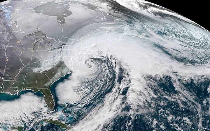
People have become familiar with “bomb cyclones” this winter, as several powerful winter storms brought strong winds and heavy precipitation to the U.S. east coast, knocking out power and causing flooding. With strength that can rival that of hurricanes, bomb cyclones get their name from a process called bombogenesis, which describes the rapid intensification they undergo within 24 hours as they move along the coast.
These winter storms tend to form and travel within narrow “atmospheric conveyor belts”, called storm tracks, which can change location over a period of years.
Scientists have extensively studied potential causes behind these year-to-year changes in attempt to better forecast storm tracks and their extreme impacts, but new research from scientists at the Stony Brook University (SBU) School of Marine and Atmospheric Sciences, funded by NOAA Research’s MAPP Program, identifies another crucial controlling force.
After analyzing 38 years of model data, the research team found that an alternating pattern of winds high up in the tropical stratosphere, called the Quasi-Biennial Oscillation (QBO), affects significant year-to-year changes in both the North Pacific and North Atlantic storm tracks.
The QBO’s dual influence
Past research has primarily considered how variabilities in the lower part of our atmosphere — the troposphere — and in the polar region of our stratosphere influence storm tracks. These studies mostly found that different atmospheric patterns affected storm tracks in just one ocean basin. For instance, the El Niño-Southern Oscillation influences the North Pacific storm track but not the North Atlantic storm track.
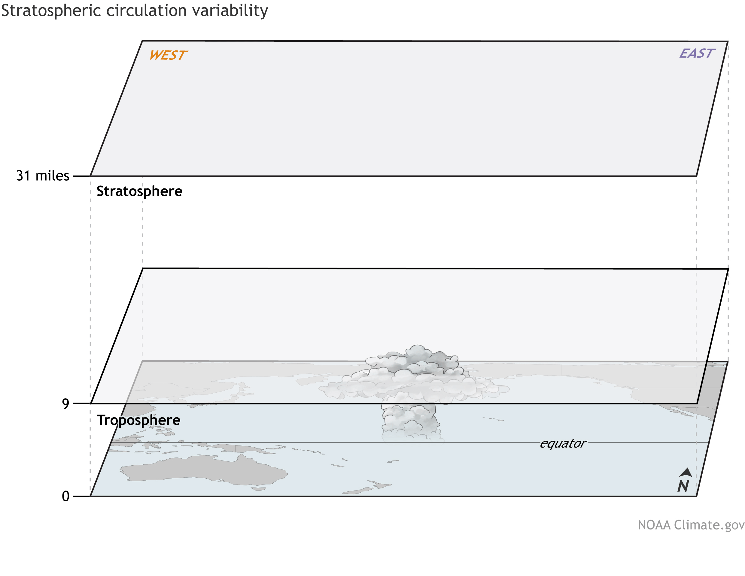 [The wind in the tropical stratosphere shifts between easterlies and westerlies over two to three years. This alternating pattern, called the QBO, can influence the location of the North Pacific and North Atlantic storm tracks, or the atmospheric conveyor belts that carry storms like bomb cyclones along the U.S. coasts. Credit: NOAA Climate animation.]
“This study finds that the QBO modulates the North Pacific and North Atlantic storm track simultaneously. Such a finding on a basin-wide influence is relatively new,” said Hyemi Kim, paper co-author and SBU Assistant Professor.
Not only does the QBO influence both the North Pacific and North Atlantic storm tracks, but the authors also found that the two storm tracks respond differently.
“When the QBO pattern has easterly winds, the North Pacific storm track shifts further north, while the North Atlantic storm track shifts to a lower vertical height in the atmosphere,” said Jiabao Wang, graduate researcher and lead author of the paper.
In addition, when the QBO pattern has westerly winds, the North Atlantic storm track shifts to a higher vertical height in the atmosphere. The authors explained that these directional and vertical shifts in storm track locations can cause changes in local weather and climate, such as strong winds and heavy precipitation, and can impact aviation by causing severe turbulence in higher or lower parts of the atmosphere.
[The wind in the tropical stratosphere shifts between easterlies and westerlies over two to three years. This alternating pattern, called the QBO, can influence the location of the North Pacific and North Atlantic storm tracks, or the atmospheric conveyor belts that carry storms like bomb cyclones along the U.S. coasts. Credit: NOAA Climate animation.]
“This study finds that the QBO modulates the North Pacific and North Atlantic storm track simultaneously. Such a finding on a basin-wide influence is relatively new,” said Hyemi Kim, paper co-author and SBU Assistant Professor.
Not only does the QBO influence both the North Pacific and North Atlantic storm tracks, but the authors also found that the two storm tracks respond differently.
“When the QBO pattern has easterly winds, the North Pacific storm track shifts further north, while the North Atlantic storm track shifts to a lower vertical height in the atmosphere,” said Jiabao Wang, graduate researcher and lead author of the paper.
In addition, when the QBO pattern has westerly winds, the North Atlantic storm track shifts to a higher vertical height in the atmosphere. The authors explained that these directional and vertical shifts in storm track locations can cause changes in local weather and climate, such as strong winds and heavy precipitation, and can impact aviation by causing severe turbulence in higher or lower parts of the atmosphere.
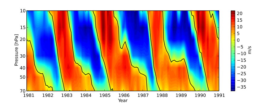 [QBO plot during the 1980s. From the Free University of Berlin]
“Because the QBO is a fairly uniform circumglobal phenomenon, we thought that its influence on storm tracks over the two basins would be similar,” said Wang. “The different responses between the North Pacific and North Atlantic storm track to the QBO were not as expected.”
Given that the QBO’s alternating pattern every 2-3 years can be accurately predicted up to 12 months in advance, Edmund Chang, co-author and SBU Professor, explained that these storm track changes and, potentially, the likelihood of related natural disasters should be predictable out to several months ahead of time. Thus, their study offers a new pathway to improve seasonal forecasts of storm tracks and their extreme impacts — like future winter weather bombs.
If forecasters take the QBO into account, Chang noted that the potential prediction improvements would provide useful information to advance decision-making in many sectors, including wind and solar energy, agriculture, water management, and emergency response.
Edited for WeatherNation by Meteorologist Mace Michaels
[QBO plot during the 1980s. From the Free University of Berlin]
“Because the QBO is a fairly uniform circumglobal phenomenon, we thought that its influence on storm tracks over the two basins would be similar,” said Wang. “The different responses between the North Pacific and North Atlantic storm track to the QBO were not as expected.”
Given that the QBO’s alternating pattern every 2-3 years can be accurately predicted up to 12 months in advance, Edmund Chang, co-author and SBU Professor, explained that these storm track changes and, potentially, the likelihood of related natural disasters should be predictable out to several months ahead of time. Thus, their study offers a new pathway to improve seasonal forecasts of storm tracks and their extreme impacts — like future winter weather bombs.
If forecasters take the QBO into account, Chang noted that the potential prediction improvements would provide useful information to advance decision-making in many sectors, including wind and solar energy, agriculture, water management, and emergency response.
Edited for WeatherNation by Meteorologist Mace Michaels
[The wind in the tropical stratosphere shifts between easterlies and westerlies over two to three years. This alternating pattern, called the QBO, can influence the location of the North Pacific and North Atlantic storm tracks, or the atmospheric conveyor belts that carry storms like bomb cyclones along the U.S. coasts. Credit: NOAA Climate animation.]
“This study finds that the QBO modulates the North Pacific and North Atlantic storm track simultaneously. Such a finding on a basin-wide influence is relatively new,” said Hyemi Kim, paper co-author and SBU Assistant Professor.
Not only does the QBO influence both the North Pacific and North Atlantic storm tracks, but the authors also found that the two storm tracks respond differently.
“When the QBO pattern has easterly winds, the North Pacific storm track shifts further north, while the North Atlantic storm track shifts to a lower vertical height in the atmosphere,” said Jiabao Wang, graduate researcher and lead author of the paper.
In addition, when the QBO pattern has westerly winds, the North Atlantic storm track shifts to a higher vertical height in the atmosphere. The authors explained that these directional and vertical shifts in storm track locations can cause changes in local weather and climate, such as strong winds and heavy precipitation, and can impact aviation by causing severe turbulence in higher or lower parts of the atmosphere.
[QBO plot during the 1980s. From the Free University of Berlin]
“Because the QBO is a fairly uniform circumglobal phenomenon, we thought that its influence on storm tracks over the two basins would be similar,” said Wang. “The different responses between the North Pacific and North Atlantic storm track to the QBO were not as expected.”
Given that the QBO’s alternating pattern every 2-3 years can be accurately predicted up to 12 months in advance, Edmund Chang, co-author and SBU Professor, explained that these storm track changes and, potentially, the likelihood of related natural disasters should be predictable out to several months ahead of time. Thus, their study offers a new pathway to improve seasonal forecasts of storm tracks and their extreme impacts — like future winter weather bombs.
If forecasters take the QBO into account, Chang noted that the potential prediction improvements would provide useful information to advance decision-making in many sectors, including wind and solar energy, agriculture, water management, and emergency response.
Edited for WeatherNation by Meteorologist Mace MichaelsAll Weather News
More


After Reaching Category 5, Genevieve Weakens in the Pacific
PacificFausto is now a post-tropical cyclone.
30 Jul 2026 12:00 PM

Flooding Risk Increases as Heavy Rain Targets the Tri-State Area
Tuesday, heavy rainfall moved across the Nort
30 Jul 2026 12:25 AM

Severe Weather: Energy From the Midwest Now in the Southeast
UPPER MIDWEST - Through Monday, dangerous tor
29 Jul 2026 10:30 PM

Southeast Flood Risk Lingers Near Stalled Front
A stalled boundary over the Southeast will ke
25 Jul 2026 10:55 AM

Another Round of Storms Targets the Northeast
Tuesday brought severe weather again across p
23 Jul 2026 1:15 AM