Jet Stream "Traffic Jams" Cause Abnormal Weather Patterns
Special Stories
22 Jun 2018 9:34 AM
From University of Chicago
The sky sometimes has its limits, according to new research from two University of Chicago atmospheric scientists.
A study published May 24 in Science offers an explanation for a mysterious and sometimes deadly weather pattern in which the jet stream, the global air currents that circle the Earth, stalls out over a region. Much like highways, the jet stream has a capacity, researchers said, and when it’s exceeded, blockages form that are remarkably similar to traffic jams—and forecasters can use the same math to model them both.
The deadly 2003 European heat wave, California’s 2014 drought and the swing of Superstorm Sandy in 2012 that surprised forecasters—all of these were caused by a weather phenomenon known as “blocking,” in which the jet stream meanders, stopping weather systems from moving eastward. Scientists have known about it for decades, almost as long as they’ve known about the jet stream—which was explored in the last century by pioneering University of Chicago meteorologist Carl-Gustaf Rossby, in fact—but no one had a good explanation for why it happens.
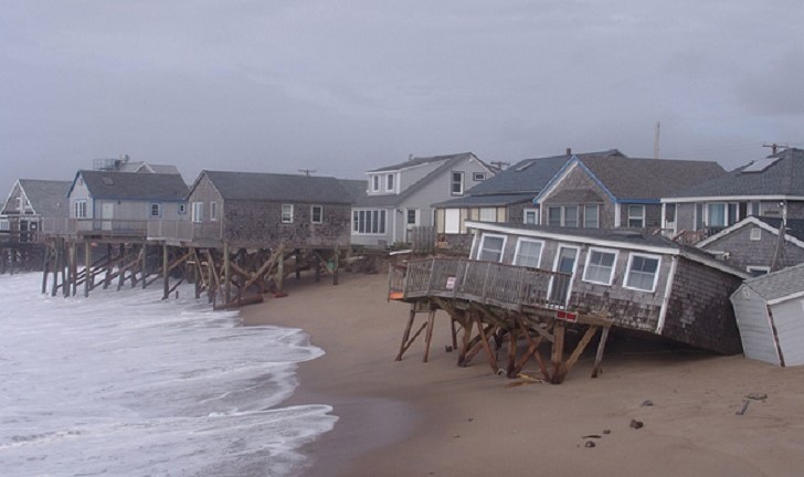 [Beachfront homes in the aftermath of Post-tropical Cyclone Sandy in 2012.]
“Blocking is notoriously difficult to forecast, in large part because there was no compelling theory about when it forms and why,” said lead author Noboru Nakamura, a professor in the Department of the Geophysical Sciences.
Nakamura and Clare S.Y. Huang, PhD'17, were studying the jet stream, trying to determine a clear set of measurements for blocking in order to better analyze the phenomenon. One of their new metrics was a term that measured the jet stream’s meander. Looking over the math, Nakamura realized that the equation was nearly identical to one devised decades ago by transportation engineers trying to describe traffic jams.
“It turns out the jet stream has a capacity for ‘weather traffic,’ just as highway has traffic capacity, and when it is exceeded, blocking manifests as congestion,” said Huang, who performed the research for her thesis.
[Beachfront homes in the aftermath of Post-tropical Cyclone Sandy in 2012.]
“Blocking is notoriously difficult to forecast, in large part because there was no compelling theory about when it forms and why,” said lead author Noboru Nakamura, a professor in the Department of the Geophysical Sciences.
Nakamura and Clare S.Y. Huang, PhD'17, were studying the jet stream, trying to determine a clear set of measurements for blocking in order to better analyze the phenomenon. One of their new metrics was a term that measured the jet stream’s meander. Looking over the math, Nakamura realized that the equation was nearly identical to one devised decades ago by transportation engineers trying to describe traffic jams.
“It turns out the jet stream has a capacity for ‘weather traffic,’ just as highway has traffic capacity, and when it is exceeded, blocking manifests as congestion,” said Huang, who performed the research for her thesis.
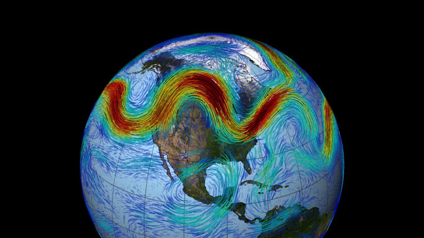
 [A wind map shows a typical blocking pattern in the Pacific, where the winds split and circle around. (Original image by earth.nullschool.net) via Gfycat]
Just as car traffic piles up where speed limit is reduced or multiple highways converge, blocking often occurs where the background jet speed slows down due to mountains and coasts.
The result is a simple theory that not only reproduces blocking, but predicts it, said Nakamura, who called making the cross-disciplinary connection “one of the most unexpected, but enlightening moments in my research career—it was a gift from God.”
The explanation may not immediately improve short-term weather forecasting, the researchers said, but it will certainly help predict long-term patterns, including which areas may see more drought or floods.
[A wind map shows a typical blocking pattern in the Pacific, where the winds split and circle around. (Original image by earth.nullschool.net) via Gfycat]
Just as car traffic piles up where speed limit is reduced or multiple highways converge, blocking often occurs where the background jet speed slows down due to mountains and coasts.
The result is a simple theory that not only reproduces blocking, but predicts it, said Nakamura, who called making the cross-disciplinary connection “one of the most unexpected, but enlightening moments in my research career—it was a gift from God.”
The explanation may not immediately improve short-term weather forecasting, the researchers said, but it will certainly help predict long-term patterns, including which areas may see more drought or floods.
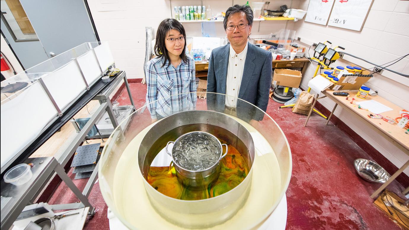 [Clare S. Y. Huang (left) and Prof. Noboru Nakamura demonstrate an experiment that shows how temperature contrasts and rotation create the polar jet stream. Photo by Jean Lachat]
Their initial results suggest that while climate change probably increases blocking by running the jet stream closer to its capacity, there will be regional differences: for example, the Pacific Ocean may actually see a decrease in blocking over the decades.
“It’s very difficult to forecast anything until you understand why it’s happening, so this mechanistic model should provide a useful guiding principle,” Nakamura said.
And the model, unlike most modern climate science, is expressed in simple math: “This equation captures the essence with a much less complicated system,” Huang said.
Edited for WeatherNation by Meteorologist Mace Michaels
[Clare S. Y. Huang (left) and Prof. Noboru Nakamura demonstrate an experiment that shows how temperature contrasts and rotation create the polar jet stream. Photo by Jean Lachat]
Their initial results suggest that while climate change probably increases blocking by running the jet stream closer to its capacity, there will be regional differences: for example, the Pacific Ocean may actually see a decrease in blocking over the decades.
“It’s very difficult to forecast anything until you understand why it’s happening, so this mechanistic model should provide a useful guiding principle,” Nakamura said.
And the model, unlike most modern climate science, is expressed in simple math: “This equation captures the essence with a much less complicated system,” Huang said.
Edited for WeatherNation by Meteorologist Mace Michaels
[Beachfront homes in the aftermath of Post-tropical Cyclone Sandy in 2012.]
“Blocking is notoriously difficult to forecast, in large part because there was no compelling theory about when it forms and why,” said lead author Noboru Nakamura, a professor in the Department of the Geophysical Sciences.
Nakamura and Clare S.Y. Huang, PhD'17, were studying the jet stream, trying to determine a clear set of measurements for blocking in order to better analyze the phenomenon. One of their new metrics was a term that measured the jet stream’s meander. Looking over the math, Nakamura realized that the equation was nearly identical to one devised decades ago by transportation engineers trying to describe traffic jams.
“It turns out the jet stream has a capacity for ‘weather traffic,’ just as highway has traffic capacity, and when it is exceeded, blocking manifests as congestion,” said Huang, who performed the research for her thesis.
[A wind map shows a typical blocking pattern in the Pacific, where the winds split and circle around. (Original image by earth.nullschool.net) via Gfycat]
Just as car traffic piles up where speed limit is reduced or multiple highways converge, blocking often occurs where the background jet speed slows down due to mountains and coasts.
The result is a simple theory that not only reproduces blocking, but predicts it, said Nakamura, who called making the cross-disciplinary connection “one of the most unexpected, but enlightening moments in my research career—it was a gift from God.”
The explanation may not immediately improve short-term weather forecasting, the researchers said, but it will certainly help predict long-term patterns, including which areas may see more drought or floods.
[Clare S. Y. Huang (left) and Prof. Noboru Nakamura demonstrate an experiment that shows how temperature contrasts and rotation create the polar jet stream. Photo by Jean Lachat]
Their initial results suggest that while climate change probably increases blocking by running the jet stream closer to its capacity, there will be regional differences: for example, the Pacific Ocean may actually see a decrease in blocking over the decades.
“It’s very difficult to forecast anything until you understand why it’s happening, so this mechanistic model should provide a useful guiding principle,” Nakamura said.
And the model, unlike most modern climate science, is expressed in simple math: “This equation captures the essence with a much less complicated system,” Huang said.
Edited for WeatherNation by Meteorologist Mace MichaelsAll Weather News
More
Tropics: Bertha Dissipates, Fausto Heads to Hawaii
BerthaBertha has now moved inland into easter
23 Jul 2026 8:00 PM

Flash Flooding for the Carolinas This Week
A stalled boundary over the Carolinas will ke
23 Jul 2026 7:45 PM

Hot & Smoky w/ a Chance of Lightning
Conditions have been really dry out west. We'
23 Jul 2026 1:20 PM

Another Round of Storms Targets the Northeast
Tuesday brought severe weather again across p
23 Jul 2026 1:15 AM

Another Round of Severe Weather for the Upper Midwest and Great Lakes
The upper-level low train continues to keep t
21 Jul 2026 1:45 AM

Air Quality Improvements in the Forecast
Wildfires burning in Northwestern Ontario, Ca
20 Jul 2026 7:20 PM

Monsoon Moisture Brings Weekend Flood Threat
The monsoon has returned to the southwestern
19 Jul 2026 1:30 AM