June El Nino Update: Concentrate and Ask Again
Special Stories
14 Jun 2019 4:44 AM
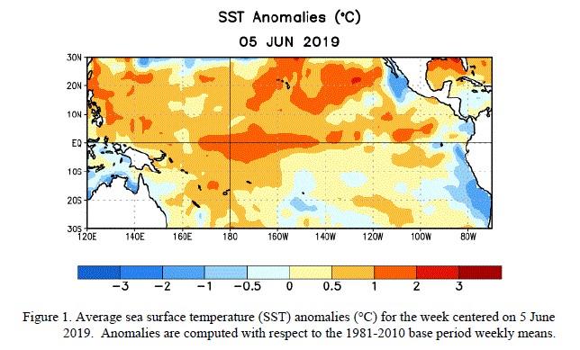
[NOAA by Emily Becker] Our El Niño is still hanging around, and forecasters think it’s likely to stay through the summer. What happens after that is less clear, though, with about a 50% chance of El Niño continuing through the fall and winter.
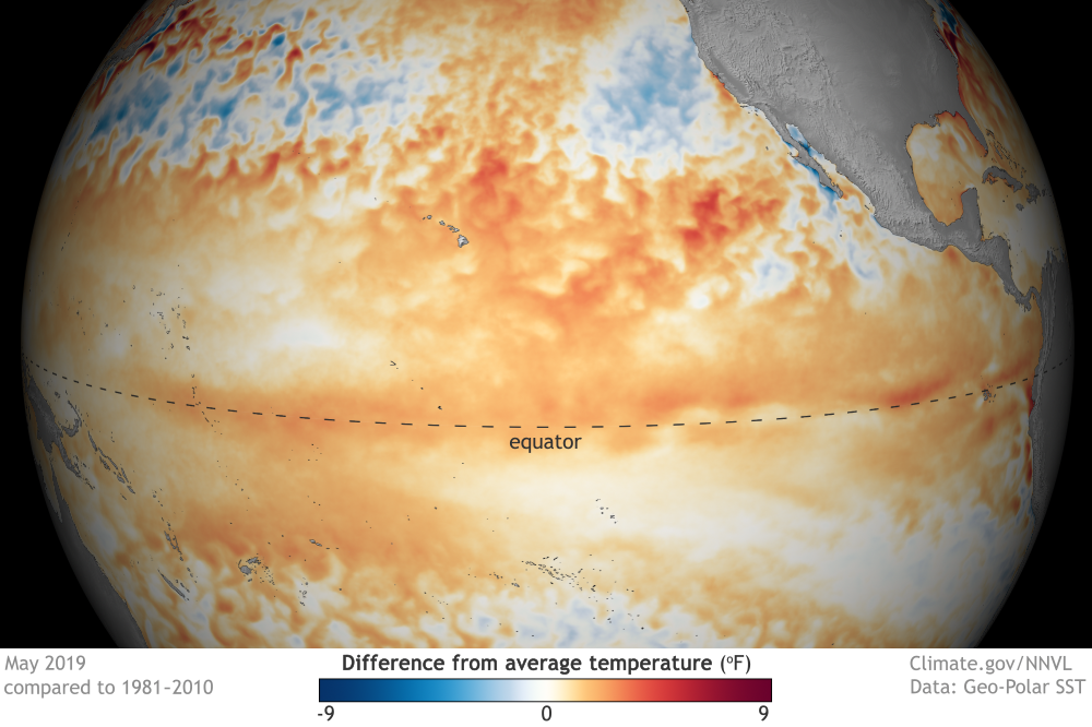 [May 2019 sea surface temperature departure from the 1981-2010 average. Image from Data Snapshots from NOAA Climate; data from NOAA’s Environmental Visualization Lab.]
The atmosphere also reflected weak El Niño during May, and both the Southern Oscillation Index the Equatorial Southern Oscillation Index were moderately negative. When these indexes are negative, it means the surface air pressure over the far western Pacific is higher than average (more sinking air) and the surface air pressure over the central-eastern Pacific is lower than average (more rising air), indicative of a weakened Walker circulation.
[May 2019 sea surface temperature departure from the 1981-2010 average. Image from Data Snapshots from NOAA Climate; data from NOAA’s Environmental Visualization Lab.]
The atmosphere also reflected weak El Niño during May, and both the Southern Oscillation Index the Equatorial Southern Oscillation Index were moderately negative. When these indexes are negative, it means the surface air pressure over the far western Pacific is higher than average (more sinking air) and the surface air pressure over the central-eastern Pacific is lower than average (more rising air), indicative of a weakened Walker circulation.
Things as they are
The sea surface temperature across much of the tropical Pacific is still warmer than average, with the Niño3.4 Index coming in at 0.64°C above average during May (via ERSSTv5).
[May 2019 sea surface temperature departure from the 1981-2010 average. Image from Data Snapshots from NOAA Climate; data from NOAA’s Environmental Visualization Lab.]
The atmosphere also reflected weak El Niño during May, and both the Southern Oscillation Index the Equatorial Southern Oscillation Index were moderately negative. When these indexes are negative, it means the surface air pressure over the far western Pacific is higher than average (more sinking air) and the surface air pressure over the central-eastern Pacific is lower than average (more rising air), indicative of a weakened Walker circulation.
Things that were
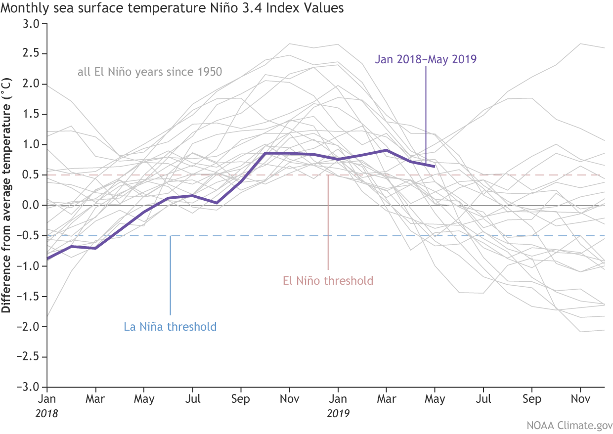
Speaking of the Niño3.4 index—it’s been just bumping along between 0.5° and 1°C above average for several months in a row. This behavior is fairly unusual.[Monthly sea surface temperature in the Niño 3.4 region of the tropical Pacific for 2018–19 (purple line) and all other El Niño years since 1950. Climate.gov graph based on ERSSTv5 temperature data.]
Of the 23 El Niño winters in our historical record (dating back to 1950), nine persisted into March–May. Six of those were stronger El Niños, with the three-month-average Niño3.4 Index (the “Oceanic Niño Index” or ONI) peaking at 1.5°C or more above average.
Two winters, 1968–69 and 1986–87, featured a peak ONI of 1.1°C and 1.2°C (respectively) and persisted into the spring. Only once before now has the ONI remained above 0.5°C but less than 1°C above average throughout the winter and lasted into the spring: 2014–15. In that instance, March 2015 was technically the start of the great El Niño of 2015-16.
These three cases were all followed by El Niño the next winter. The predictive value of this factoid is not large, though, and I’m really just providing you fodder for your next very esoteric trivia night. You can revisit Tony’s excellent post from 2014 for an explanation of why past is not prologue, but essentially, the ocean/atmosphere system is so complex that from year to year, even if some elements (like the ONI) look the same, there are many, many other differences. These differences mean that conditions will develop differently, leading to unique futures. My favorite part of Tony’s post is that it would take approximately one trillion quintillion years for nature to repeat itself!
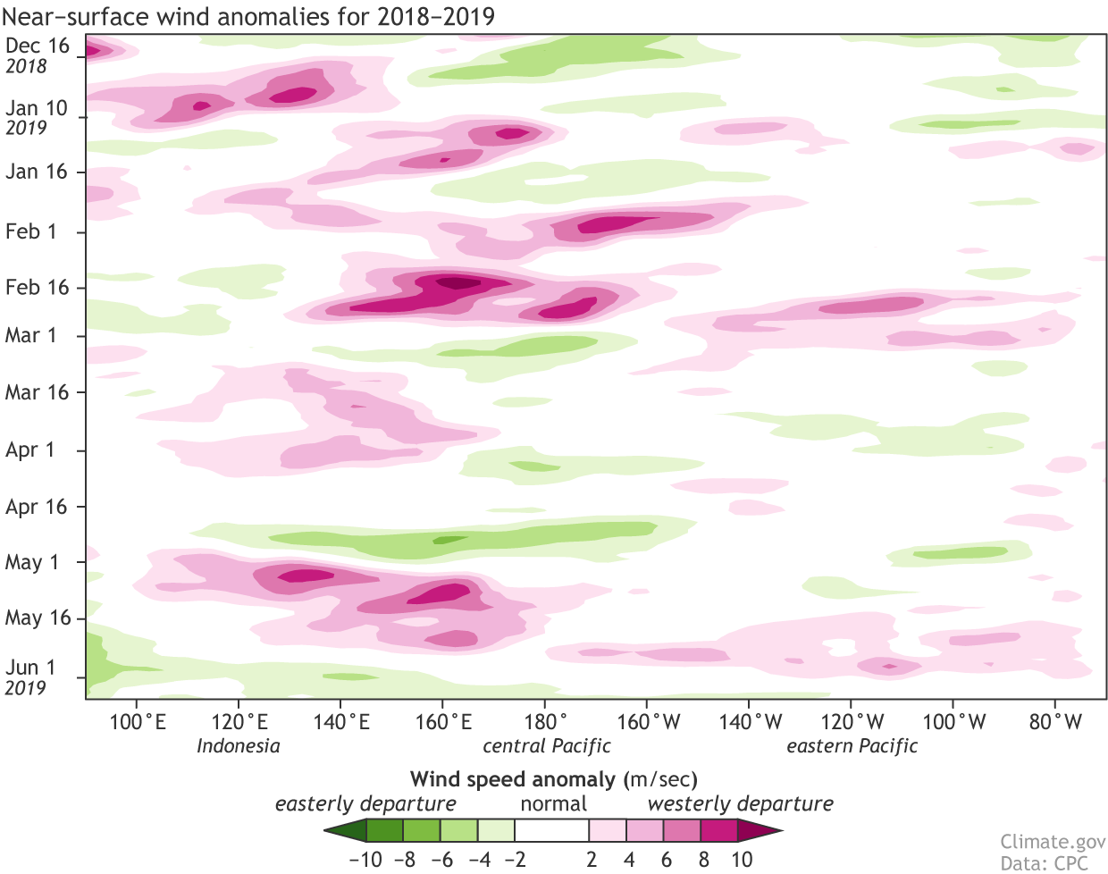 [Near-surface wind anomalies over the tropical Pacific (5°N-5°S) during 2018, starting at the top in December 2018 and ending in early June 2019 at the bottom. Each row in this type of image is the departure from average (1981-2010) at that time. Pink areas show weaker-than-average trade winds, and green stronger. NOAA Climate image, based on data provided by the Climate Prediction Center.]
Near-term, one of the conditions we look at is how the winds near the surface of the tropical Pacific—the trade winds—are behaving. The trade winds normally blow steadily east-to-west, keeping warm water piled up near Indonesia. When they slow down, that warm water can begin to slide eastward under the surface—a downwelling Kelvin wave—transferring warmer waters to the east. This warm wave eventually rises to the surface, reinforcing the El Niño.
Throughout most of May, the trade winds were weaker than average.
The effect of these weaker winds can be seen in the recent increase of warmer-than-average water under the surface of the tropical Pacific, as a new downwelling Kelvin wave has formed. (But not a Kelvin wave of cinematic proportions.)
[Near-surface wind anomalies over the tropical Pacific (5°N-5°S) during 2018, starting at the top in December 2018 and ending in early June 2019 at the bottom. Each row in this type of image is the departure from average (1981-2010) at that time. Pink areas show weaker-than-average trade winds, and green stronger. NOAA Climate image, based on data provided by the Climate Prediction Center.]
Near-term, one of the conditions we look at is how the winds near the surface of the tropical Pacific—the trade winds—are behaving. The trade winds normally blow steadily east-to-west, keeping warm water piled up near Indonesia. When they slow down, that warm water can begin to slide eastward under the surface—a downwelling Kelvin wave—transferring warmer waters to the east. This warm wave eventually rises to the surface, reinforcing the El Niño.
Throughout most of May, the trade winds were weaker than average.
The effect of these weaker winds can be seen in the recent increase of warmer-than-average water under the surface of the tropical Pacific, as a new downwelling Kelvin wave has formed. (But not a Kelvin wave of cinematic proportions.)
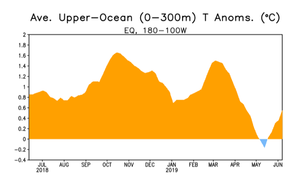 [Area-averaged upper-ocean temperature anomaly (°C) in the equatorial Pacific (5°N-5°S, 180º-100ºW). The anomaly is computed as the departure from the 1981-2010 base period pentad (5-day) means. Upper ocean temperature anomalies were nearly average at the start of May, but anomalies increased toward the end of the month in association with a downwelling Kelvin wave. CPC figure.]
Over the next few months, this Kelvin wave will likely (66% chance!) supply the surface with the warmer-than-average water required to continue El Niño through the summer. Since the end of May, the trade winds have strengthened, mostly due to an active Madden-Julian Oscillation. The MJO has been distracting the tropical Pacific before and during this El Niño, providing “subseasonal variability” (changes in the atmospheric pattern on timescales of weeks).
For an idea of the longer term, we can look to computer models. Overall, the models in the current forecast predict that the Niño3.4 Index will stay near to slightly above the El Niño threshold of 0.5°C warmer than average. Some models are in the ENSO-neutral range, around average. It’s interesting that nearly all of the models remain between 0.0 and +1.0°C through the fall and into the winter; this level of agreement between the models would usually contribute to more confidence in the forecast. However, the mix of predictions above and below the El Niño threshold means that, while El Niño is the favorite for next winter, forecasters are giving it only a 50% chance at this point.
Edited for WeatherNation by Meteorologist Mace Michaels
[Area-averaged upper-ocean temperature anomaly (°C) in the equatorial Pacific (5°N-5°S, 180º-100ºW). The anomaly is computed as the departure from the 1981-2010 base period pentad (5-day) means. Upper ocean temperature anomalies were nearly average at the start of May, but anomalies increased toward the end of the month in association with a downwelling Kelvin wave. CPC figure.]
Over the next few months, this Kelvin wave will likely (66% chance!) supply the surface with the warmer-than-average water required to continue El Niño through the summer. Since the end of May, the trade winds have strengthened, mostly due to an active Madden-Julian Oscillation. The MJO has been distracting the tropical Pacific before and during this El Niño, providing “subseasonal variability” (changes in the atmospheric pattern on timescales of weeks).
For an idea of the longer term, we can look to computer models. Overall, the models in the current forecast predict that the Niño3.4 Index will stay near to slightly above the El Niño threshold of 0.5°C warmer than average. Some models are in the ENSO-neutral range, around average. It’s interesting that nearly all of the models remain between 0.0 and +1.0°C through the fall and into the winter; this level of agreement between the models would usually contribute to more confidence in the forecast. However, the mix of predictions above and below the El Niño threshold means that, while El Niño is the favorite for next winter, forecasters are giving it only a 50% chance at this point.
Edited for WeatherNation by Meteorologist Mace Michaels
Hints of what’s to come
So what has more predictive power? To develop the most complete picture of how conditions in the tropical Pacific might develop over the next several months, ENSO forecasters study current conditions and dynamical and statistical computer models. (From the grimaces I sometimes see after forecasters consider the latest model runs, I suspect some of us consult soothsayers, as well…)
[Near-surface wind anomalies over the tropical Pacific (5°N-5°S) during 2018, starting at the top in December 2018 and ending in early June 2019 at the bottom. Each row in this type of image is the departure from average (1981-2010) at that time. Pink areas show weaker-than-average trade winds, and green stronger. NOAA Climate image, based on data provided by the Climate Prediction Center.]
Near-term, one of the conditions we look at is how the winds near the surface of the tropical Pacific—the trade winds—are behaving. The trade winds normally blow steadily east-to-west, keeping warm water piled up near Indonesia. When they slow down, that warm water can begin to slide eastward under the surface—a downwelling Kelvin wave—transferring warmer waters to the east. This warm wave eventually rises to the surface, reinforcing the El Niño.
Throughout most of May, the trade winds were weaker than average.
The effect of these weaker winds can be seen in the recent increase of warmer-than-average water under the surface of the tropical Pacific, as a new downwelling Kelvin wave has formed. (But not a Kelvin wave of cinematic proportions.)
[Area-averaged upper-ocean temperature anomaly (°C) in the equatorial Pacific (5°N-5°S, 180º-100ºW). The anomaly is computed as the departure from the 1981-2010 base period pentad (5-day) means. Upper ocean temperature anomalies were nearly average at the start of May, but anomalies increased toward the end of the month in association with a downwelling Kelvin wave. CPC figure.]
Over the next few months, this Kelvin wave will likely (66% chance!) supply the surface with the warmer-than-average water required to continue El Niño through the summer. Since the end of May, the trade winds have strengthened, mostly due to an active Madden-Julian Oscillation. The MJO has been distracting the tropical Pacific before and during this El Niño, providing “subseasonal variability” (changes in the atmospheric pattern on timescales of weeks).
For an idea of the longer term, we can look to computer models. Overall, the models in the current forecast predict that the Niño3.4 Index will stay near to slightly above the El Niño threshold of 0.5°C warmer than average. Some models are in the ENSO-neutral range, around average. It’s interesting that nearly all of the models remain between 0.0 and +1.0°C through the fall and into the winter; this level of agreement between the models would usually contribute to more confidence in the forecast. However, the mix of predictions above and below the El Niño threshold means that, while El Niño is the favorite for next winter, forecasters are giving it only a 50% chance at this point.
Edited for WeatherNation by Meteorologist Mace Michaels
All Weather News
More
Flooding & Severe Storms Target the Southwest
A low pressure system coming across the Weste
23 Oct 2026 2:05 AM

Tropical Storm Vance Forms In The Pacific
Isaias ended the late-season streak of no hur
23 Oct 2026 2:00 AM

Warmer Than Average: Above-Normal Temperatures Across the Central U.S. This Week
WHAT TO EXPECTA ridge of high pressure will b
23 Oct 2026 1:45 AM


Several Fires Break Out in SoCal Last Week Amid Santa Ana Wind Event
Santa Ana winds helped several fires grow qui
19 Oct 2026 1:25 PM

Another Cold Morning Before Things Warm Back Up
Across portions of the Ohio Valley through th
19 Oct 2026 10:15 AM

Severe Risk Diminishing Saturday Morning for the Northeast
Severe Storm PotentialSevere risk is decreasi
16 Oct 2026 10:20 AM