June La Nina Update: Neutral Noodle
Special Stories
16 Jun 2021 1:58 AM
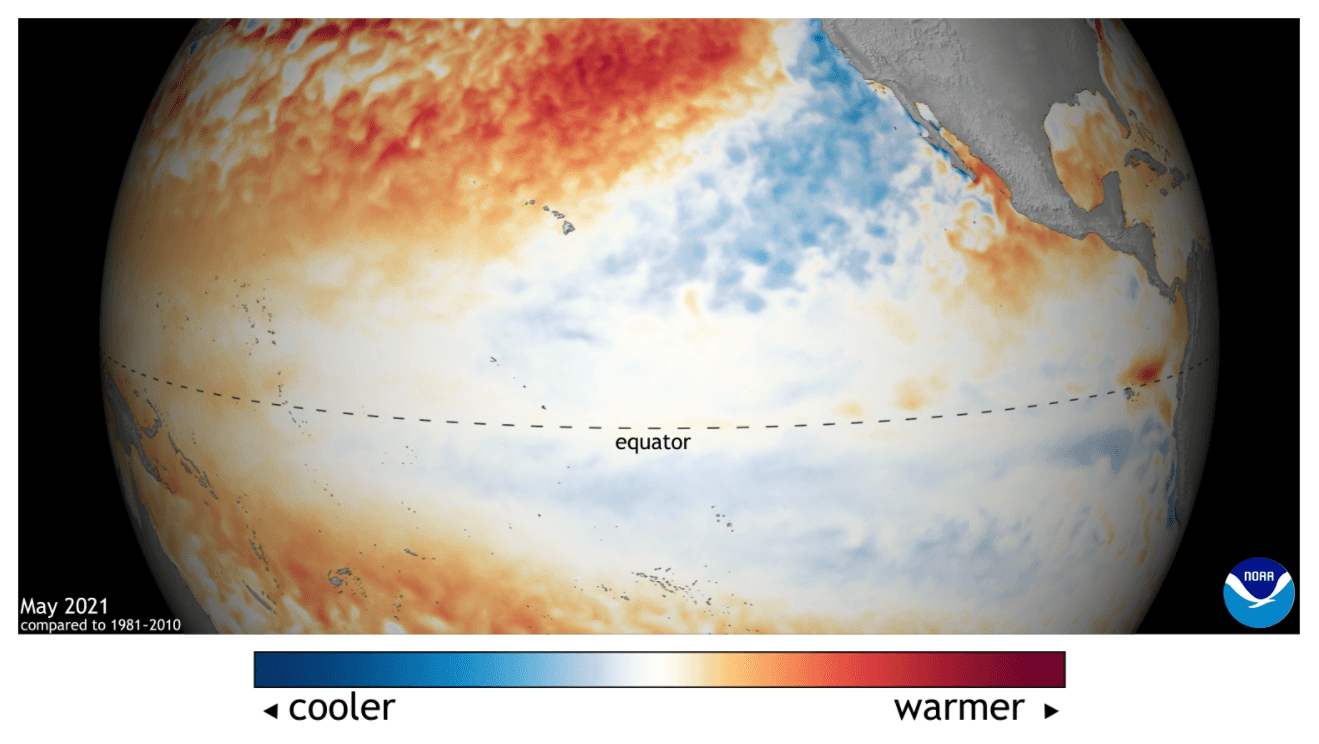
[May 2021 Pacific Ocean sea surface temperature departure from the 1981-2010 average. Image from Data Snapshots on NOAA Climate.]
[From NOAA written by Emily Becker] ENSO-neutral conditions are present in the tropical Pacific, and NOAA forecasters think they’re likely to continue through the summer. Neutral is slightly favored through the fall, although it’s a close call between continued neutral and re-developing La Niña for the late fall and winter.
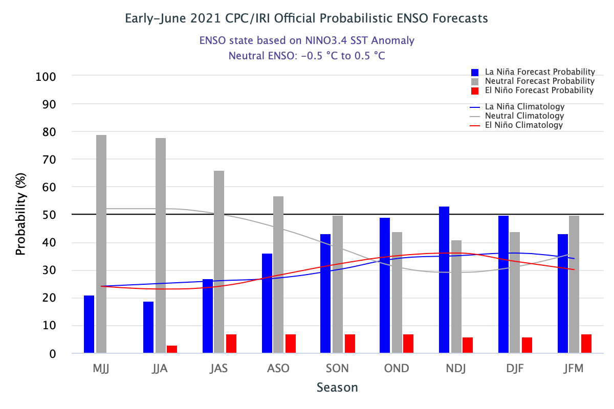 [The official CPC/IRI ENSO probability forecast, based on a consensus of CPC and IRI forecasters. It is updated during the first half of the month, in association with the official CPC/IRI ENSO Diagnostic Discussion. It is based on observational and predictive information from early in the month and from the previous month. Image from IRI.]
The chance of neutral drops, and La Niña chances rise, through the fall, until the probability of La Niña overtakes neutral in October–December and reaches 53% for November–January. As Nat discussed last month, La Niña has a tendency to appear in consecutive winters. Meanwhile, the official forecast summary emphasizes neutral. NOAA has an ENSO Alert System for when La Niña (or El Niño) is expected to develop… why hasn’t it been activated for La Niña? There are a few reasons! Let’s noodle on this.
A La Niña Watch is issued when “conditions are favorable for the development of El Niño or La Niña conditions within the next six months,” and we’re still more than six months from the November–January season (we count by the center month). Also, many climate models predict neutral will continue through the fall and winter, and there is no consensus among the models that the Niño3.4 sea surface temperature will remain more than 0.5°C cooler than average for more than a few months. By January–March, neutral is again the most likely category. This is important, because ENSO is a seasonal system, requiring sustained conditions to impact global weather and climate.
In summary, there just isn’t enough evidence yet to tip the scales definitively between neutral and La Niña for this coming winter. One thing we can say with confidence is that chances for El Niño next fall/winter are low—less than 10%.
[The official CPC/IRI ENSO probability forecast, based on a consensus of CPC and IRI forecasters. It is updated during the first half of the month, in association with the official CPC/IRI ENSO Diagnostic Discussion. It is based on observational and predictive information from early in the month and from the previous month. Image from IRI.]
The chance of neutral drops, and La Niña chances rise, through the fall, until the probability of La Niña overtakes neutral in October–December and reaches 53% for November–January. As Nat discussed last month, La Niña has a tendency to appear in consecutive winters. Meanwhile, the official forecast summary emphasizes neutral. NOAA has an ENSO Alert System for when La Niña (or El Niño) is expected to develop… why hasn’t it been activated for La Niña? There are a few reasons! Let’s noodle on this.
A La Niña Watch is issued when “conditions are favorable for the development of El Niño or La Niña conditions within the next six months,” and we’re still more than six months from the November–January season (we count by the center month). Also, many climate models predict neutral will continue through the fall and winter, and there is no consensus among the models that the Niño3.4 sea surface temperature will remain more than 0.5°C cooler than average for more than a few months. By January–March, neutral is again the most likely category. This is important, because ENSO is a seasonal system, requiring sustained conditions to impact global weather and climate.
In summary, there just isn’t enough evidence yet to tip the scales definitively between neutral and La Niña for this coming winter. One thing we can say with confidence is that chances for El Niño next fall/winter are low—less than 10%.
 We care about ENSO prediction because it can provide an early picture of potential climate conditions months in advance. (Also because it’s a super-interesting geophysical phenomenon, but that might just be us geeks!) One important aspect of ENSO is its influence on hurricane activity.
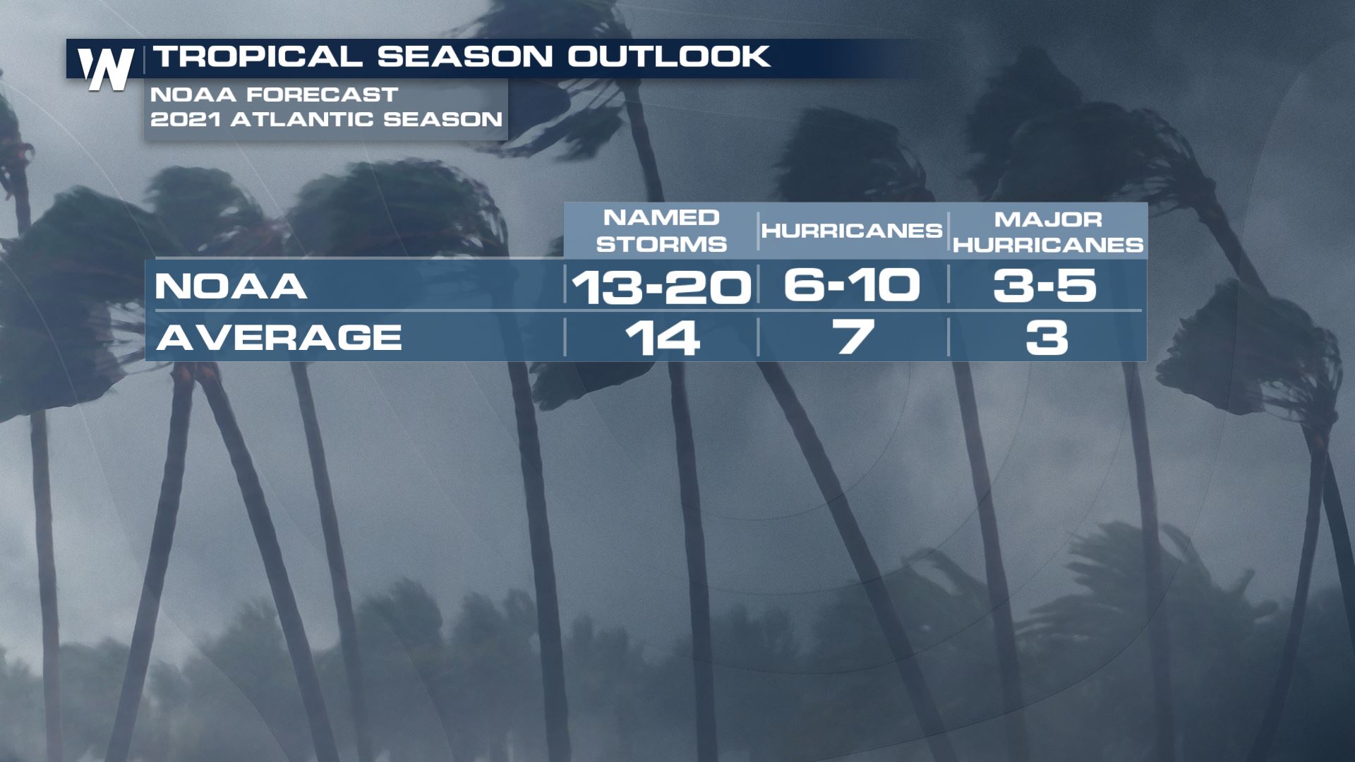
NOAA’s recent Atlantic hurricane outlook predicts an active season, with a 60% chance of above-average activity. The low chance of El Niño (which tends to suppress hurricane activity in the Atlantic) was an important component in this outlook. Other factors, such as predicted warmer-than-average tropical Atlantic sea surface temperatures, bolster the outlook. On the other hand, the Central and Eastern Pacific are expected to have normal or below-normal tropical storm seasons. El Niño tends to enhance storm activity in those regions.
We care about ENSO prediction because it can provide an early picture of potential climate conditions months in advance. (Also because it’s a super-interesting geophysical phenomenon, but that might just be us geeks!) One important aspect of ENSO is its influence on hurricane activity.
NOAA’s recent Atlantic hurricane outlook predicts an active season, with a 60% chance of above-average activity. The low chance of El Niño (which tends to suppress hurricane activity in the Atlantic) was an important component in this outlook. Other factors, such as predicted warmer-than-average tropical Atlantic sea surface temperatures, bolster the outlook. On the other hand, the Central and Eastern Pacific are expected to have normal or below-normal tropical storm seasons. El Niño tends to enhance storm activity in those regions.
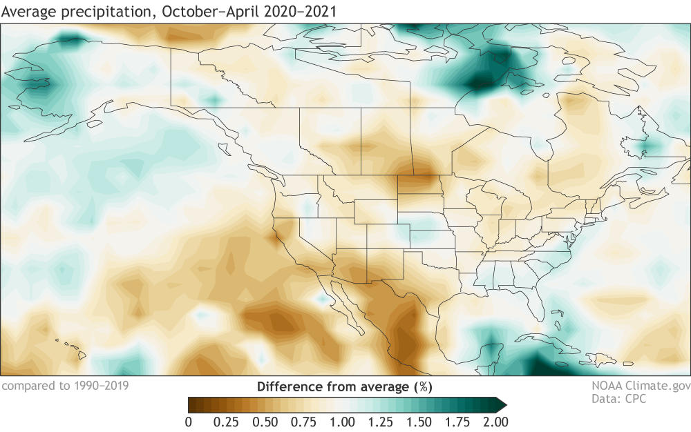 [Percent of average precipitation (rain, snow, and other frozen precipitation) during October–April 2020–21. Average period is 1990–2019. Data from GPCP via ESRL PSL; image by NOAA Climate.]
Another reason to care about long-range ENSO prediction is its relationship to rainfall in the southwestern US. La Niña is linked to reduced late-fall/winter/early-spring rain and snow in this region, while El Niño tends to enhance rain in the southwest. During La Niña 2020–21, much of the Southwest US and Mexico was indeed below average.
[Percent of average precipitation (rain, snow, and other frozen precipitation) during October–April 2020–21. Average period is 1990–2019. Data from GPCP via ESRL PSL; image by NOAA Climate.]
Another reason to care about long-range ENSO prediction is its relationship to rainfall in the southwestern US. La Niña is linked to reduced late-fall/winter/early-spring rain and snow in this region, while El Niño tends to enhance rain in the southwest. During La Niña 2020–21, much of the Southwest US and Mexico was indeed below average.
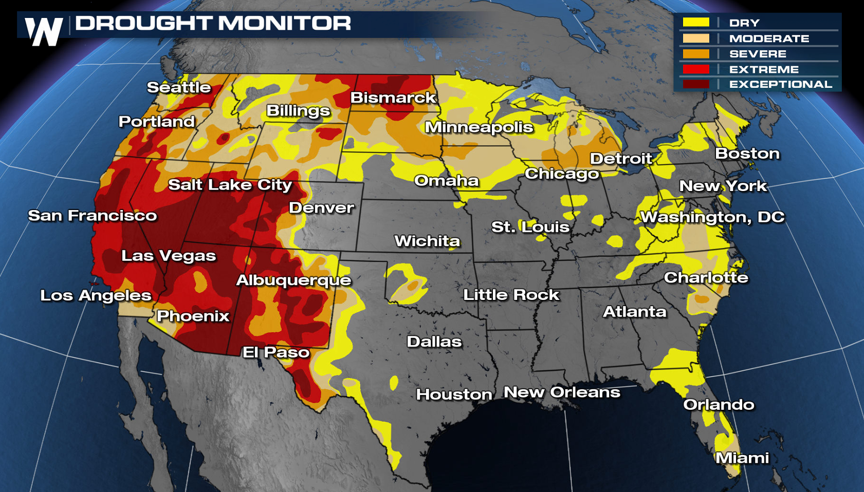 A huge portion of the western US is now in extreme drought, and the seasonal drought outlook predicts drought conditions to continue through the summer. Mexico is also experiencing widespread and intense drought. Second-year La Niña has been linked to more pronounced drought, another concern if La Niña does re-develop.
La Niña is also usually related to increased winter rain and snow in the Pacific Northwest, which did not materialize this past year. Since apparently I’m just linking to all of Nat’s posts today, here’s the one about the unexpected conditions we saw during the 2020–21 La Niña.
A huge portion of the western US is now in extreme drought, and the seasonal drought outlook predicts drought conditions to continue through the summer. Mexico is also experiencing widespread and intense drought. Second-year La Niña has been linked to more pronounced drought, another concern if La Niña does re-develop.
La Niña is also usually related to increased winter rain and snow in the Pacific Northwest, which did not materialize this past year. Since apparently I’m just linking to all of Nat’s posts today, here’s the one about the unexpected conditions we saw during the 2020–21 La Niña.
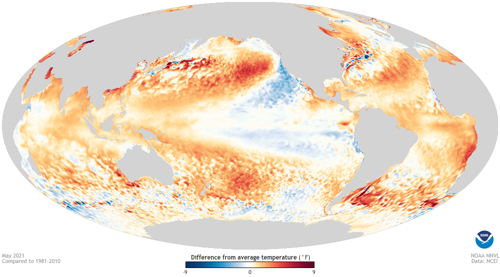 [May 2021 sea surface temperature departure from the 1981-2010 average (note that this image still uses the previous averaging period). Image from Data Snapshots on NOAA Climate.]
Finally, let’s take a look at the global sea surface temperature pattern from May, where we can see that much of the North Atlantic is already warmer than average.
Although La Niña conditions have ended, there are still regions of cooler-than-average surface waters to in the eastern Pacific and southwest of the US. What I’d really like to point out here, though, is the re-emergent blob in the north Pacific. According to NOAA’s Blobtracker (official name: California Current Marine Heatwave Tracker) this marine heatwave formed in late April and has tripled in area since then. It formed in the same spot as a powerful marine heatwave that dominated much of 2020 and was the 2nd-largest on record (their record starts in 1982). Yet another ocean feature that bears watching.
Edited for WeatherNation by Mace Michaels
[May 2021 sea surface temperature departure from the 1981-2010 average (note that this image still uses the previous averaging period). Image from Data Snapshots on NOAA Climate.]
Finally, let’s take a look at the global sea surface temperature pattern from May, where we can see that much of the North Atlantic is already warmer than average.
Although La Niña conditions have ended, there are still regions of cooler-than-average surface waters to in the eastern Pacific and southwest of the US. What I’d really like to point out here, though, is the re-emergent blob in the north Pacific. According to NOAA’s Blobtracker (official name: California Current Marine Heatwave Tracker) this marine heatwave formed in late April and has tripled in area since then. It formed in the same spot as a powerful marine heatwave that dominated much of 2020 and was the 2nd-largest on record (their record starts in 1982). Yet another ocean feature that bears watching.
Edited for WeatherNation by Mace Michaels
Neutral soup
I often start my top-of-the-month posts with a detailed review of the current conditions in the tropical Pacific, but I think I’ll just breeze through that and get to the forecast today. Currently, sea surface temperatures in the ENSO monitoring regions are still slightly cooler than average, but within the neutral range of +/- 0.5°C from the long-term (1991–2020) average. Neutral conditions are likely through the summer: there’s a 78% chance that the sea surface temperature in the Niño3.4 region of the Pacific ocean will be close to the long-term average—within the neutral range—during June–August. The sea surface temperature in the Niño3.4 region is our primary ENSO-monitoring index.
[The official CPC/IRI ENSO probability forecast, based on a consensus of CPC and IRI forecasters. It is updated during the first half of the month, in association with the official CPC/IRI ENSO Diagnostic Discussion. It is based on observational and predictive information from early in the month and from the previous month. Image from IRI.]
The chance of neutral drops, and La Niña chances rise, through the fall, until the probability of La Niña overtakes neutral in October–December and reaches 53% for November–January. As Nat discussed last month, La Niña has a tendency to appear in consecutive winters. Meanwhile, the official forecast summary emphasizes neutral. NOAA has an ENSO Alert System for when La Niña (or El Niño) is expected to develop… why hasn’t it been activated for La Niña? There are a few reasons! Let’s noodle on this.
A La Niña Watch is issued when “conditions are favorable for the development of El Niño or La Niña conditions within the next six months,” and we’re still more than six months from the November–January season (we count by the center month). Also, many climate models predict neutral will continue through the fall and winter, and there is no consensus among the models that the Niño3.4 sea surface temperature will remain more than 0.5°C cooler than average for more than a few months. By January–March, neutral is again the most likely category. This is important, because ENSO is a seasonal system, requiring sustained conditions to impact global weather and climate.
In summary, there just isn’t enough evidence yet to tip the scales definitively between neutral and La Niña for this coming winter. One thing we can say with confidence is that chances for El Niño next fall/winter are low—less than 10%.
Tuna neutral casserole
We care about ENSO prediction because it can provide an early picture of potential climate conditions months in advance. (Also because it’s a super-interesting geophysical phenomenon, but that might just be us geeks!) One important aspect of ENSO is its influence on hurricane activity.
NOAA’s recent Atlantic hurricane outlook predicts an active season, with a 60% chance of above-average activity. The low chance of El Niño (which tends to suppress hurricane activity in the Atlantic) was an important component in this outlook. Other factors, such as predicted warmer-than-average tropical Atlantic sea surface temperatures, bolster the outlook. On the other hand, the Central and Eastern Pacific are expected to have normal or below-normal tropical storm seasons. El Niño tends to enhance storm activity in those regions.
[Percent of average precipitation (rain, snow, and other frozen precipitation) during October–April 2020–21. Average period is 1990–2019. Data from GPCP via ESRL PSL; image by NOAA Climate.]
Another reason to care about long-range ENSO prediction is its relationship to rainfall in the southwestern US. La Niña is linked to reduced late-fall/winter/early-spring rain and snow in this region, while El Niño tends to enhance rain in the southwest. During La Niña 2020–21, much of the Southwest US and Mexico was indeed below average.
A huge portion of the western US is now in extreme drought, and the seasonal drought outlook predicts drought conditions to continue through the summer. Mexico is also experiencing widespread and intense drought. Second-year La Niña has been linked to more pronounced drought, another concern if La Niña does re-develop.
La Niña is also usually related to increased winter rain and snow in the Pacific Northwest, which did not materialize this past year. Since apparently I’m just linking to all of Nat’s posts today, here’s the one about the unexpected conditions we saw during the 2020–21 La Niña.
Buttered neutrals
[May 2021 sea surface temperature departure from the 1981-2010 average (note that this image still uses the previous averaging period). Image from Data Snapshots on NOAA Climate.]
Finally, let’s take a look at the global sea surface temperature pattern from May, where we can see that much of the North Atlantic is already warmer than average.
Although La Niña conditions have ended, there are still regions of cooler-than-average surface waters to in the eastern Pacific and southwest of the US. What I’d really like to point out here, though, is the re-emergent blob in the north Pacific. According to NOAA’s Blobtracker (official name: California Current Marine Heatwave Tracker) this marine heatwave formed in late April and has tripled in area since then. It formed in the same spot as a powerful marine heatwave that dominated much of 2020 and was the 2nd-largest on record (their record starts in 1982). Yet another ocean feature that bears watching.
Edited for WeatherNation by Mace MichaelsAll Weather News
More
Fronts Continue To Spark Severe Weather Across the Plains
A cold front that brought record lows to the
18 Jul 2025 10:40 PM

Extreme Heat Impacts for the East Coast & South
Extreme heat continues to impact several area
18 Jul 2025 10:05 PM

Flooding Threat Remains Elevated in the East
A cold front pushing through the Eastern Seab
18 Jul 2025 9:10 PM

EF-2 Firenado from the Deer Creek Fire in Utah
A fire tornado was spotted near La Sal, Utah
18 Jul 2025 7:30 AM

Tropical System Brings Flood Risk to the Central Gulf
Time has run out for notable tropical develop
18 Jul 2025 3:05 AM

Heavy Rain, Flooding Threat Returns to Florida
Keep the rain boots handy in Florida - heavy
13 Jul 2025 12:50 PM

Severe Storm Risk Pushes into the Great Lakes, Ohio Valley
Friday was another busy day with severe weath
12 Jul 2025 8:00 PM