Laser Light System Among The Armada Of Tools Used In Tornado Radar Research
Special Stories
17 Jun 2019 11:05 PM
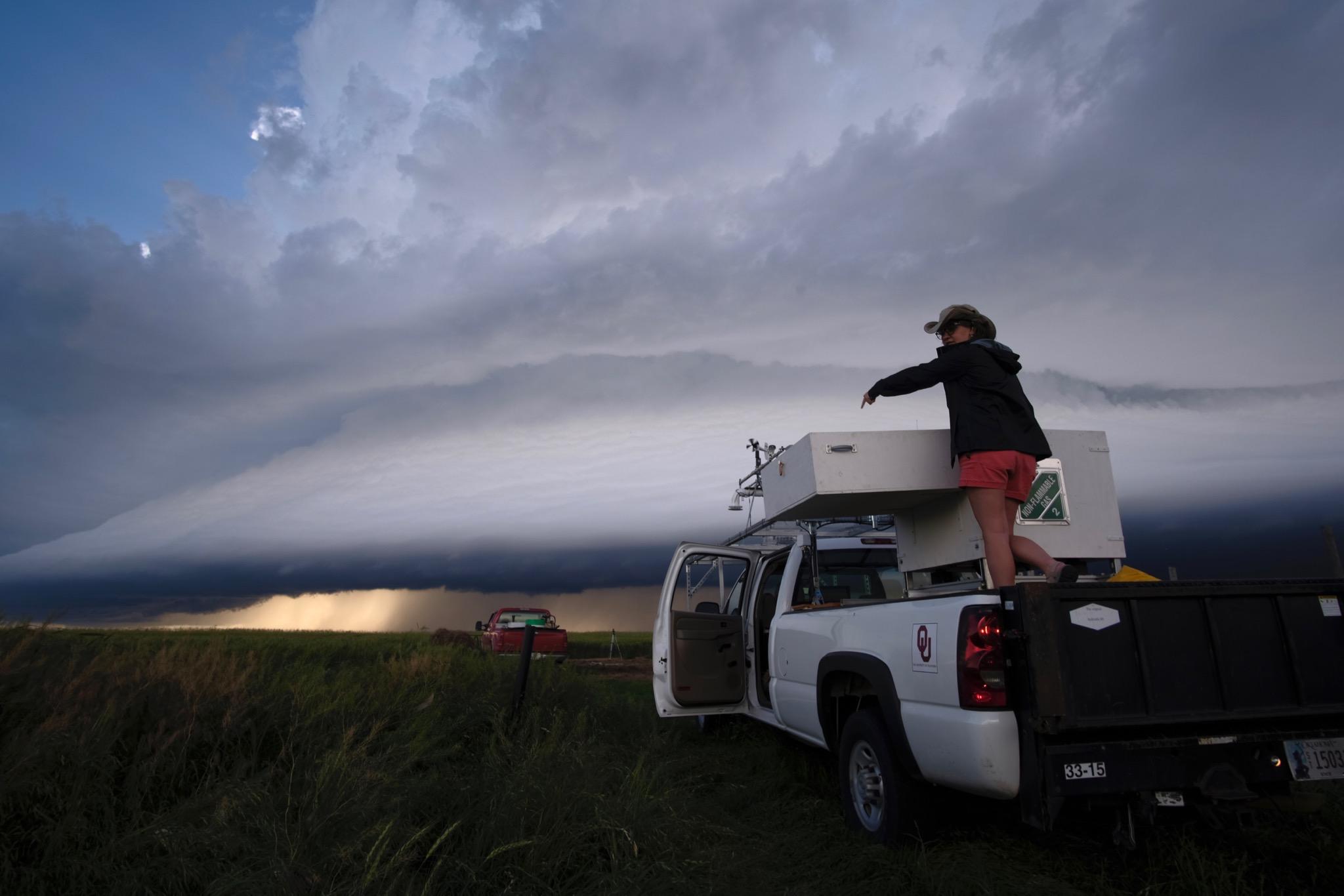
[Researcher Elizabeth Smith preparing the LiDAR system for operation on the outskirts of a storm. (Photo by Mike Coniglio/NOAA NSSL)]
[NOAA] Researcher Elizabeth Smith sits in the backseat of a white Chevy pick-up truck surrounded by computer equipment on a windy day in Oklahoma. Smith works as a University of Oklahoma Cooperative Institute for Mesoscale Meteorological Studies researcher supporting NOAA’s National Severe Storms Laboratory. On this day she’s testing equipment after a recent deployment on TORUS, or Targeted Observation by Radars and UAS of Supercells. The project aims at understanding the relationships between severe thunderstorms and tornado formation.
In the back of the pick-up truck is a LiDAR system, which stands for LIght Detection And Ranging. Unlike radar systems, LiDAR utilizes laser light. The LiDAR utilizes a 1.5-micron wavelength, just on the edge of visible light. “The LiDAR fires out laser light to hit particles that are small enough for that specific wavelength,” Smith said. “Those are things you and I can’t easily see, like really, really small dust and aerosol particles.”
The LiDAR team collects observations utilizing the device to track how quickly all the dust, dirt and particles move in the atmosphere. “If we know how fast those particles move, we can figure out how fast the wind blows,” Smith said. “Understanding the wind field around severe storms and weather is very important for us to improve our understanding and forecasts.” The LiDAR is one of many instruments utilized in TORUS — a month long project funded by the National Science Foundation and NOAA. The LiDAR is funded by the NOAA NSSL Director’s Discretionary Research Fund to support TORUS.
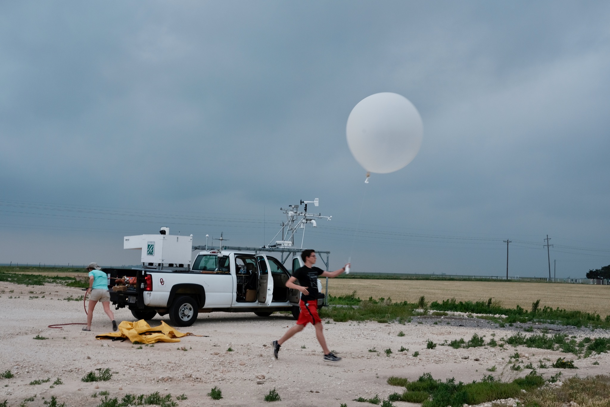 [Researchers launch weather balloons in May 2019 during TORUS. The LiDAR system team has the ability to launch weather balloons while in the field. TORUS is funded by the National Science Foundation with support from NOAA. (Photo by Mike Coniglio/NOAA NSSL)]
TORUS includes many instruments, including those on top of trucks known as mobile mesonets, as well as mobile radar trucks and unmanned aircraft vehicles. Mobile mesonets measure atmospheric factors such as wind speed, temperature and humidity at the surface while radar measures storm factors at much higher levels. As a result there is often a gap in coverage, which may be up to several hundred feet above the surface.
“We use the LiDAR and weather balloons with instruments attached to fill that gap,” Smith said. “The LiDAR system is able to provide us with wind information in minutes. There’s a lot about the environment around storms and near storms we don’t understand yet. Understanding the complex flows in that region can be very important.”
Smith said two of the most vital factors the OU CIMMS and NOAA NSSL team are studying to improve forecasting tools are how supercell thunderstorms move and persist. The team already captured several data sets to review after successful deployments in mid-May, including in Nebraska and Oklahoma.
[Researchers launch weather balloons in May 2019 during TORUS. The LiDAR system team has the ability to launch weather balloons while in the field. TORUS is funded by the National Science Foundation with support from NOAA. (Photo by Mike Coniglio/NOAA NSSL)]
TORUS includes many instruments, including those on top of trucks known as mobile mesonets, as well as mobile radar trucks and unmanned aircraft vehicles. Mobile mesonets measure atmospheric factors such as wind speed, temperature and humidity at the surface while radar measures storm factors at much higher levels. As a result there is often a gap in coverage, which may be up to several hundred feet above the surface.
“We use the LiDAR and weather balloons with instruments attached to fill that gap,” Smith said. “The LiDAR system is able to provide us with wind information in minutes. There’s a lot about the environment around storms and near storms we don’t understand yet. Understanding the complex flows in that region can be very important.”
Smith said two of the most vital factors the OU CIMMS and NOAA NSSL team are studying to improve forecasting tools are how supercell thunderstorms move and persist. The team already captured several data sets to review after successful deployments in mid-May, including in Nebraska and Oklahoma.
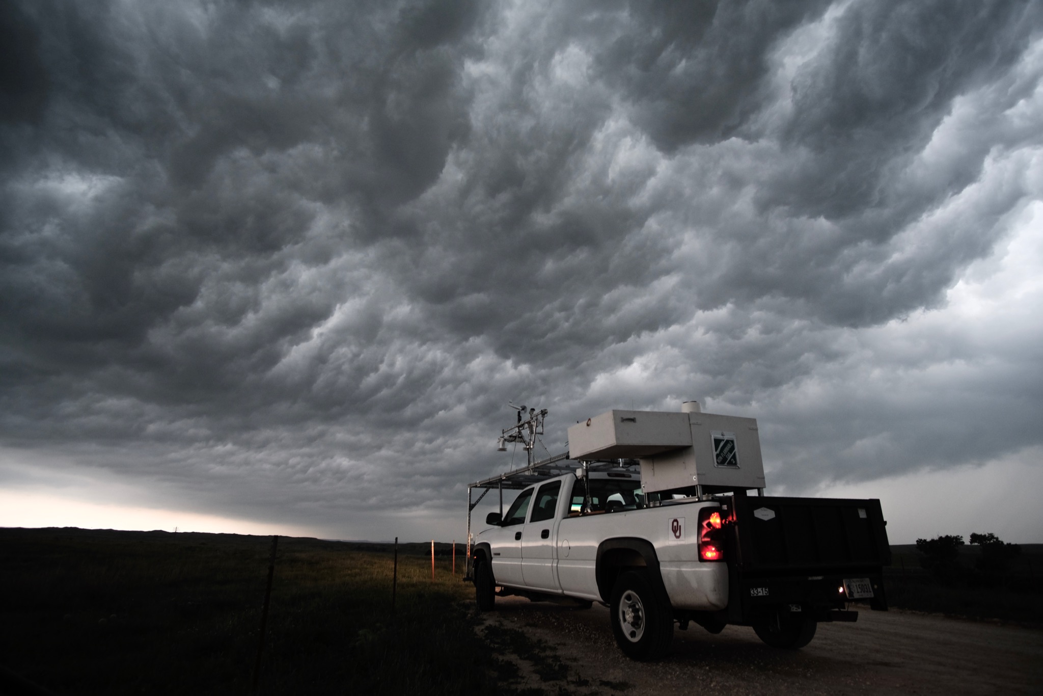 [The LiDAR system utilized in TORUS, or Targeted Observation by Radars and UAS of Supercells, is located in the back of this pickup truck. (Photo by Mike Coniglio/NOAA National Severe Storms Laboratory)]
“We saw interesting turbulence structure in the wind field,” Smith said. “We don’t know what that means just yet, but this is unprecedented data because this specific LiDAR is faster than those used in past field projects.” Smith said she doesn’t know what the data means, yet, but she does know it is interesting and poses more questions than answers until she can analyze it.
The LiDAR in the Chevy truck, lovingly named Louise, is from the NOAA NSSL CLAMPS-2trailer utilized during the Verification of the Origins of Rotation in Tornadoes EXperiment-Southeast project during the past few years. The LiDAR was removed from the trailer for increased mobility in extreme environments.
Edited for WeatherNation by Meteorologist Mace Michaels
[The LiDAR system utilized in TORUS, or Targeted Observation by Radars and UAS of Supercells, is located in the back of this pickup truck. (Photo by Mike Coniglio/NOAA National Severe Storms Laboratory)]
“We saw interesting turbulence structure in the wind field,” Smith said. “We don’t know what that means just yet, but this is unprecedented data because this specific LiDAR is faster than those used in past field projects.” Smith said she doesn’t know what the data means, yet, but she does know it is interesting and poses more questions than answers until she can analyze it.
The LiDAR in the Chevy truck, lovingly named Louise, is from the NOAA NSSL CLAMPS-2trailer utilized during the Verification of the Origins of Rotation in Tornadoes EXperiment-Southeast project during the past few years. The LiDAR was removed from the trailer for increased mobility in extreme environments.
Edited for WeatherNation by Meteorologist Mace Michaels
[Researchers launch weather balloons in May 2019 during TORUS. The LiDAR system team has the ability to launch weather balloons while in the field. TORUS is funded by the National Science Foundation with support from NOAA. (Photo by Mike Coniglio/NOAA NSSL)]
TORUS includes many instruments, including those on top of trucks known as mobile mesonets, as well as mobile radar trucks and unmanned aircraft vehicles. Mobile mesonets measure atmospheric factors such as wind speed, temperature and humidity at the surface while radar measures storm factors at much higher levels. As a result there is often a gap in coverage, which may be up to several hundred feet above the surface.
“We use the LiDAR and weather balloons with instruments attached to fill that gap,” Smith said. “The LiDAR system is able to provide us with wind information in minutes. There’s a lot about the environment around storms and near storms we don’t understand yet. Understanding the complex flows in that region can be very important.”
Smith said two of the most vital factors the OU CIMMS and NOAA NSSL team are studying to improve forecasting tools are how supercell thunderstorms move and persist. The team already captured several data sets to review after successful deployments in mid-May, including in Nebraska and Oklahoma.
[The LiDAR system utilized in TORUS, or Targeted Observation by Radars and UAS of Supercells, is located in the back of this pickup truck. (Photo by Mike Coniglio/NOAA National Severe Storms Laboratory)]
“We saw interesting turbulence structure in the wind field,” Smith said. “We don’t know what that means just yet, but this is unprecedented data because this specific LiDAR is faster than those used in past field projects.” Smith said she doesn’t know what the data means, yet, but she does know it is interesting and poses more questions than answers until she can analyze it.
The LiDAR in the Chevy truck, lovingly named Louise, is from the NOAA NSSL CLAMPS-2trailer utilized during the Verification of the Origins of Rotation in Tornadoes EXperiment-Southeast project during the past few years. The LiDAR was removed from the trailer for increased mobility in extreme environments.
Edited for WeatherNation by Meteorologist Mace MichaelsAll Weather News
More
Fronts Continue To Spark Severe Weather Across the Plains
A cold front that brought record lows to the
18 Jul 2025 10:40 PM

Extreme Heat Impacts for the East Coast & South
Extreme heat continues to impact several area
18 Jul 2025 10:05 PM

Flooding Threat Remains Elevated in the East
A cold front pushing through the Eastern Seab
18 Jul 2025 9:10 PM

EF-2 Firenado from the Deer Creek Fire in Utah
A fire tornado was spotted near La Sal, Utah
18 Jul 2025 7:30 AM

Tropical System Brings Flood Risk to the Central Gulf
Time has run out for notable tropical develop
18 Jul 2025 3:05 AM

Heavy Rain, Flooding Threat Returns to Florida
Keep the rain boots handy in Florida - heavy
13 Jul 2025 12:50 PM

Severe Storm Risk Pushes into the Great Lakes, Ohio Valley
Friday was another busy day with severe weath
12 Jul 2025 8:00 PM