Madden-Julian Oscillation Could Help Provide Earlier Forecasts for U.S. Tornadoes
Special Stories
21 May 2020 8:45 AM
Forecasting severe storms has come a long way since the first ever tornado forecast in the late 1940s, when the mechanisms that help create severe storms were poorly understood and the lead time for tornado forecasts was little to none.
Now, regions where severe storms are possible from day 1 (today) through day 8 are highlighted in outlooks by the Storm Prediction Center in addition to up to the minute products like tornado and severe thunderstorm watches. These outlooks and updates help give people time to prepare for severe weather well before it happens, sometimes more than a week in advance.
The lead time to predict those events could be more than doubled to the 14-30 day range according to a new study, due to a link between tornadogenisis in the U.S. and the Madden-Julian Oscillation.
[embed]https://www.youtube.com/watch?v=bA230B4w9t8[/embed]
Video Source: UCAR (University Corporation for Atmospheric Research)
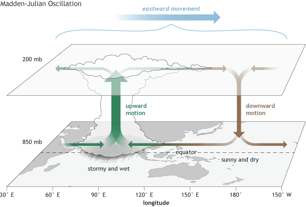
The Madden-Julian Oscillation (MJO), like ENSO (El Niño-Southern Oscillation), is a large scale atmospheric circulation in the tropics. But, while ENSO changes slowly over the course of the year (seasonal), the MJO has phases that can cycle every few weeks (meaning it is intraseasonal). The MJO has eight defined phases during which large scale ascent and thunderstorm activity is focused in one area and large scale descent (drier weather) occurs in another. These areas of ascent and descent move in an eastward motion, generally near the tropics.
In the past, the MJO has been linked to activity in the tropics and variability in temperatures (check out this article for a more detailed explanation). While past studies have also found a correlation between the MJO and tornado activity in the United States from March through July, the new study found a much more robust correlation during the late Spring and early Summer (May through July).
A summary of the correlation posted on NOAA’s Atlantic Oceanographic and Meteorological Laboratory (AOML) page states,"When the moving thunderstorm is passing across Indonesia to the Pacific, the air across Central America becomes very dry due to changes in the Walker circulation that moves upper-level air westward and lower-level air eastward across the tropical Pacific. The drying air across Central America redirects the low-level air flow to enhance the supply of warm and moist air into the U.S. east of the Rockies. This enhanced supply of warm and moist air to the U.S. destabilizes the atmosphere to produce favorable conditions for tornado activity."
Scientists at the AOML are looking at ways to apply this link in long-range weather forecasts in the United States, including the potential to expand SPC Outlooks beyond the 8 day window during the pinpointed season (May through July). This could mean additional planning time for local agencies and governments to help prepare the public for the potential for severe weather, which would help better protect lives and property.
The current status and additional information about the MJO can be found on the Climate Prediction Center's website.
All Weather News
More
Tropics: Tropical Storm Bertha Forms In the Atlantic, Eastern Pacific Active
In the Atlantic basin, we are keeping a very
21 Jul 2026 10:55 PM

Flash Flooding and Severe Weather for the Carolinas This Week
Another stalled front in the Carolinas is for
21 Jul 2026 10:50 PM

Another Round of Storms Targets the Northeast
Another cold front is dropping east and will
21 Jul 2026 10:00 PM

Pacific Northwest Fires Bringing Down the Air Quality
Conditions have been real dry out west. We've
21 Jul 2026 5:05 PM

Another Round of Severe Weather for the Upper Midwest and Great Lakes
The upper-level low train continues to keep t
21 Jul 2026 1:45 AM

Air Quality Improvements in the Forecast
Wildfires burning in Northwestern Ontario, Ca
20 Jul 2026 7:20 PM

Monsoon Moisture Brings Weekend Flood Threat
The monsoon has returned to the southwestern
19 Jul 2026 1:30 AM