May Climate Stats: A Mild Month with Limited Severe Weather

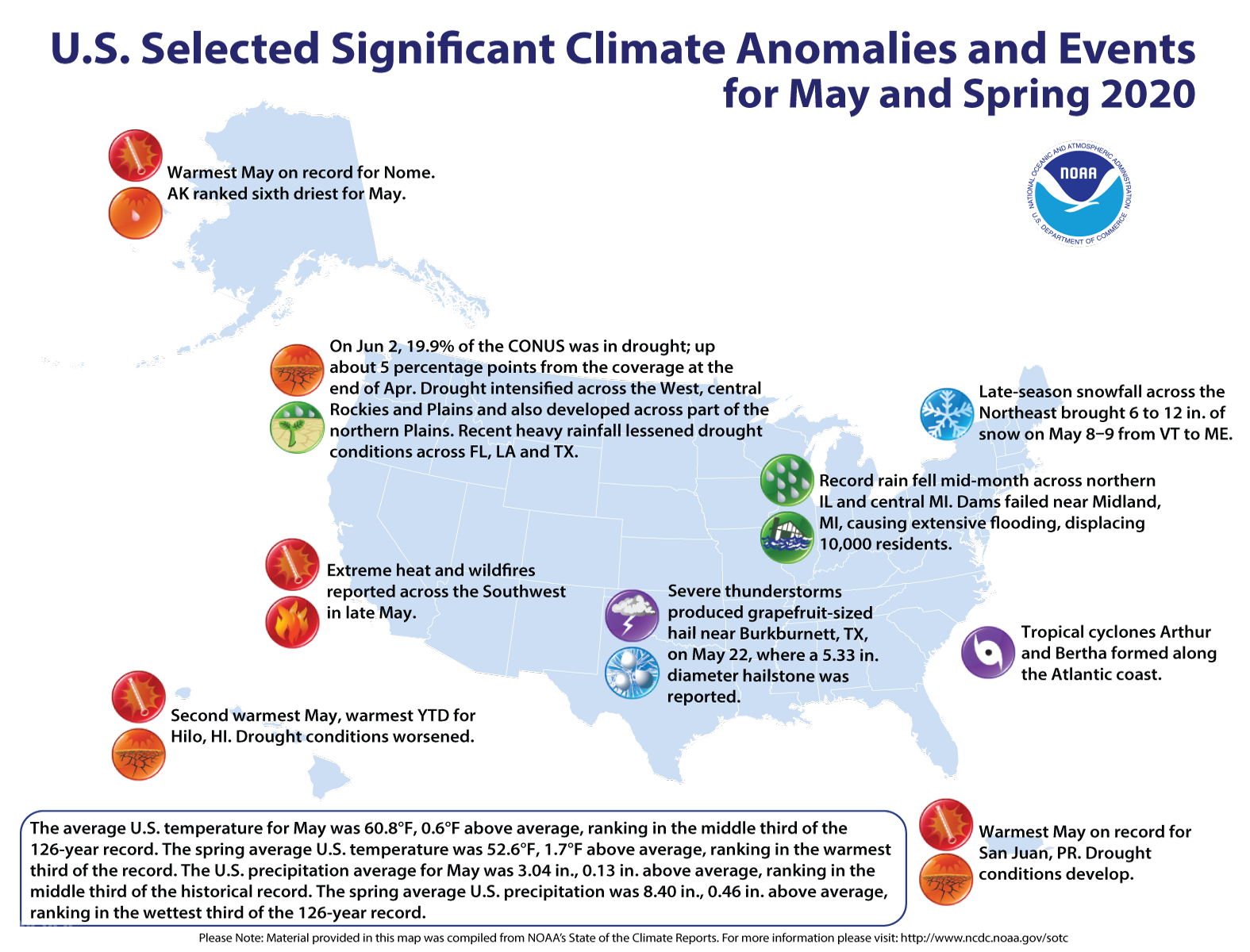
[Michigan’s Bay Region sustained an unprecedented flooding event beginning May 19, following several days of heavy rain and multiple dam failures. At its peak, more than 20 state trunkline and local bridges were impacted by flooding, resulting in immediate closures to protect the motoring public. More than 10,000 households were evacuated in Midland County over a 24-hour period. Between May 19 and 26, five Michigan counties were declared to be a state of emergency (Midland, Gladwin, Saginaw, Arenac, and Iosco). Image of a section of highway washed out in the area of Edenville, Michigan.]
[Written by NOAA] May 2020 was near average temperature-wise for the contiguous U.S., but the month capped off a warm spring and even warmer year to date, according to scientists from NOAA’s National Centers for Environmental Information.
Last month was also slightly wetter than average, as severe flooding impacted parts of the U.S., including heavy rain in the Midwest and tropical downpours in Florida.
Here are more highlights from NOAA's latest U.S. monthly climate report:
Climate by the numbers
May 2020
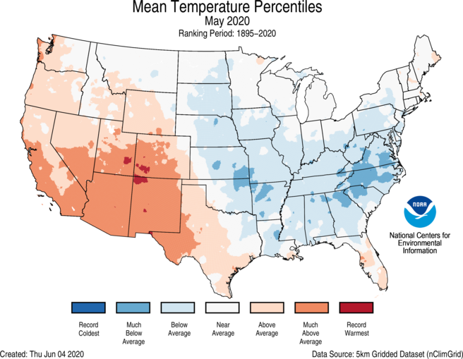
The average May temperature across the contiguous U.S. was 60.8 degrees F (0.6 of a degree above the 20th-century average), ranking in the middle third of the 126-year record.
Temperatures were highly variable across the nation last month: North Carolina had its 10th-coldest May on record, while New Mexico had its fifth-warmest.
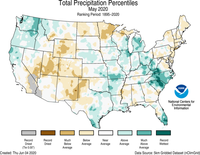
The average precipitation for May was 3.04 inches, 0.13 of an inch above average, which ranked in the middle third of the record. A soggy setup spread heavy rain across the Great Lakes region and Southeast, while drier-than-normal conditions covered the Southwest and Rockies.
Meteorological spring and the year to date
The average temperature for the contiguous U.S. during meteorological spring (March through May) was 52.6 degrees F (1.7 degrees F above the 20th-century average), which ranked in the warmest third of the record. The spring precipitation total of 8.40 inches (0.46 of an inch above average) ranked in the wettest third of the record.
The average U.S. temperature for the year to date (January through May, YTD) was 45.9 degrees F (2.6 degrees F above average); it ranked 9th-warmest YTD on record. The period was also unusually wet, with a precipitation total of 13.60 inches, 1.21 inches above average and ranking in the wettest third.
Other notable May climate events
-
Devastating flooding in Michigan: A slow-moving system in May brought several days of rain to the Midwest. The heavy rainfall contributed to catastrophic dam failures, which produced record flooding along the entire Tittabawassee River near Midland, Michigan. Officials evacuated approximately 10,000 residents in the region.
-
Early tropical troubles: Two tropical storms, Arthur and Bertha, formed in May, making it the sixth year in a row in which at least one named storm formed in the Atlantic Ocean before the official start of the hurricane season (June 1). Rainfall associated with Bertha gave Miami its wettest May on record.
-
Severe weather was scarce: May had the fewest number of severe weather reports in six years, as well as the fewest number of tornadoes and EF2+ tornadoes reported since at least 1970.
-
Drought ramped up: According to the U.S. Drought Monitor, 19.9% of the contiguous U.S. experienced drought conditions, up 5% from the end of April. Drought intensified across the West, central Rockies and Plains, while dryness developed across parts of Minnesota, North Dakota, Puerto Rico and Hawaii.
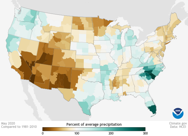 [Map of May precipitation across the United States as a percent of the 1981-2010 average. Much of the West had less than 100% of their normal precipitation (brown), while much of the East had more than 100% of their normal May precipitation (green). Map from NOAA Climate's Data Snapshots collection, based on data from NCEI.]
Edited for WeatherNation by Mace Michaels
[Map of May precipitation across the United States as a percent of the 1981-2010 average. Much of the West had less than 100% of their normal precipitation (brown), while much of the East had more than 100% of their normal May precipitation (green). Map from NOAA Climate's Data Snapshots collection, based on data from NCEI.]
Edited for WeatherNation by Mace Michaels


