May La Nina Update: Piece of Cake
Special Stories
30 May 2022 5:00 AM
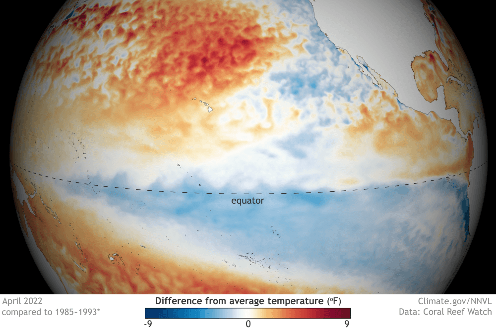
[Still cool: Sea surface temperatures across the tropical Pacific remained below average in April 2022. NOAA Climate image from our Data Snapshots collection.]
[From NOAA Climate written by Emily Becker] La Niña continued through April, and forecasters estimate a 61% chance of a La Niña three-peat for next fall and early winter. Current El Niño/Southern Oscillation (ENSO, the entire El Niño and La Niña system) conditions, the forecast for the rest of the year, and some potential impacts are all on the dessert menu today.
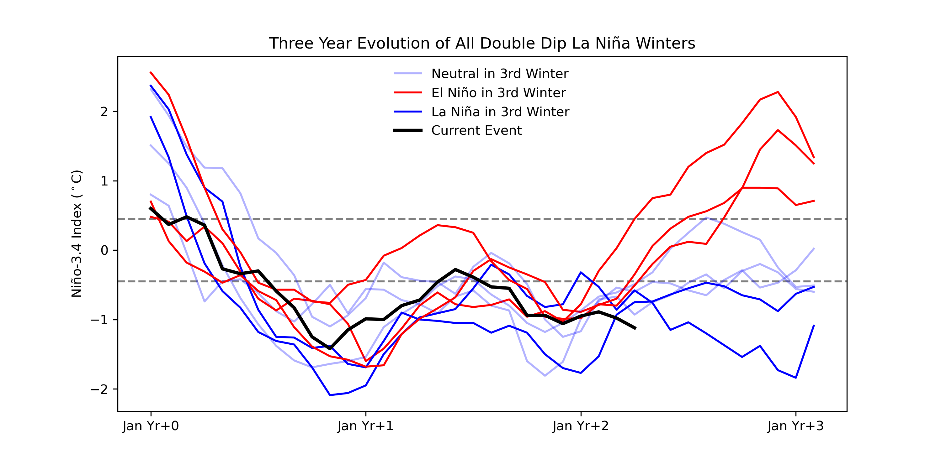 [Three-year history of sea surface temperatures in the Niño-3.4 region of the tropical Pacific for 8 previous double-dip La Niña events. The color of the line indicates the state of ENSO for the third winter (red: El Niño, darker blue: La Niña, lighter blue: neutral). The black line shows the current event. Monthly Niño-3.4 index is from CPC using ERSSTv5. Time series comparison was created by Michelle L’Heureux, and modified by NOAA Climate.]
The atmosphere also continues to reflect La Niña, with plenty of evidence of an enhanced Walker circulation. The normal Walker circulation consists of a loop of rising air over the warm waters of the far western Pacific and Indonesia, west-to-east winds aloft, descending motion over the cooler central/eastern Pacific, and east-to-west winds near the surface (the trade winds). During La Niña, the even-warmer west Pacific and even-cooler east Pacific act to strengthen the Walker circulation. In April, both the trade winds and upper-level winds were stronger than average. Along with the April 2022 pattern of more rain than average in the western Pacific and less in the central/eastern Pacific, we have ample confirmation that La Niña conditions are still going strong.
[Three-year history of sea surface temperatures in the Niño-3.4 region of the tropical Pacific for 8 previous double-dip La Niña events. The color of the line indicates the state of ENSO for the third winter (red: El Niño, darker blue: La Niña, lighter blue: neutral). The black line shows the current event. Monthly Niño-3.4 index is from CPC using ERSSTv5. Time series comparison was created by Michelle L’Heureux, and modified by NOAA Climate.]
The atmosphere also continues to reflect La Niña, with plenty of evidence of an enhanced Walker circulation. The normal Walker circulation consists of a loop of rising air over the warm waters of the far western Pacific and Indonesia, west-to-east winds aloft, descending motion over the cooler central/eastern Pacific, and east-to-west winds near the surface (the trade winds). During La Niña, the even-warmer west Pacific and even-cooler east Pacific act to strengthen the Walker circulation. In April, both the trade winds and upper-level winds were stronger than average. Along with the April 2022 pattern of more rain than average in the western Pacific and less in the central/eastern Pacific, we have ample confirmation that La Niña conditions are still going strong.
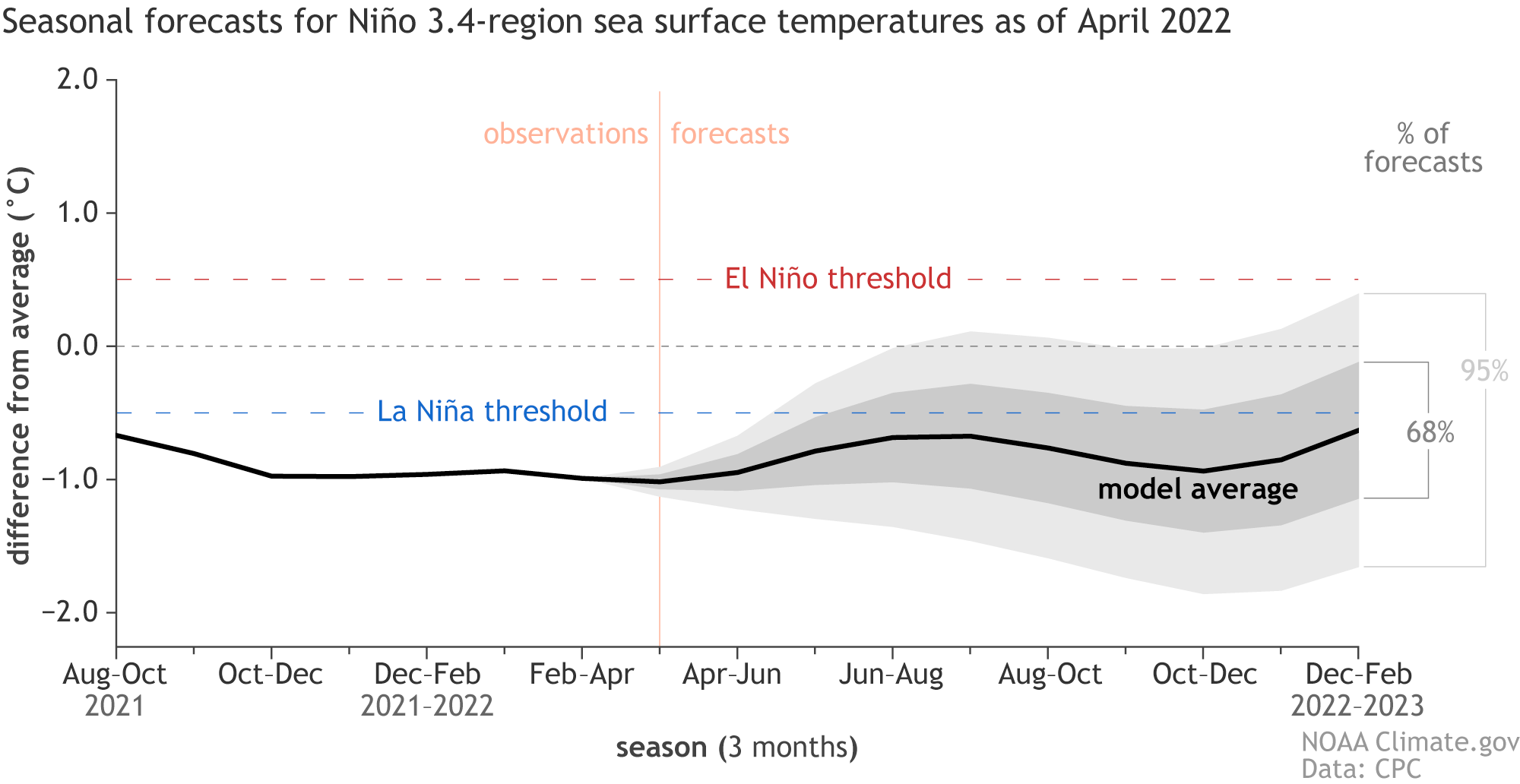 [The range of forecasts for departures from average temperatures in the Niño-3.4 region of the tropical Pacific in 2022 from the North American Multi-Model Ensemble (NMME). The average of all forecasts (black line) is below the La Niña threshold. Sixty-eight percent of the forecasts (dark gray shading) are for neutral or La Niña temperatures. Ninety-five percent (light gray shading) are below El Niño temperatures. NOAA Climate image from University of Miami data.]
As we’ve mentioned a few times here on the ENSO Blog, we’ve had La Niña for three winters in a row only twice before:1973–1976 and 1998–2001. Both of those periods followed very strong El Niño events, while the current situation follows a somewhat warm, but officially neutral winter (2019–2020). ENSO is determined to keep us on our toes, for sure.
One final note about the forecast—we’re still within the spring predictability barrier, when ENSO forecasts are generally less accurate than forecasts made at other times of the year. We’ll start to clear this barrier next month.
[The range of forecasts for departures from average temperatures in the Niño-3.4 region of the tropical Pacific in 2022 from the North American Multi-Model Ensemble (NMME). The average of all forecasts (black line) is below the La Niña threshold. Sixty-eight percent of the forecasts (dark gray shading) are for neutral or La Niña temperatures. Ninety-five percent (light gray shading) are below El Niño temperatures. NOAA Climate image from University of Miami data.]
As we’ve mentioned a few times here on the ENSO Blog, we’ve had La Niña for three winters in a row only twice before:1973–1976 and 1998–2001. Both of those periods followed very strong El Niño events, while the current situation follows a somewhat warm, but officially neutral winter (2019–2020). ENSO is determined to keep us on our toes, for sure.
One final note about the forecast—we’re still within the spring predictability barrier, when ENSO forecasts are generally less accurate than forecasts made at other times of the year. We’ll start to clear this barrier next month.
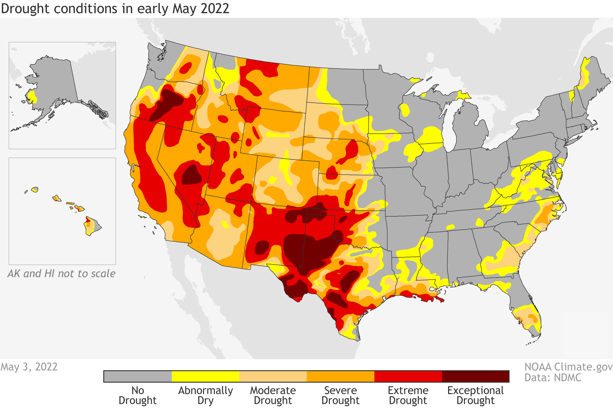 [Drought status across the United States as of May 3, 2022. More than half the country was in some level of drought, and an additional amount was abnormally dry (yellow). In many Western states, conditions were extreme (bright red) or exceptional (dark red). A third winter of La Niña is unlikely to be good news for the country's southern tier. NOAA Climate map, based on data from the U.S. Drought Monitor project.]
More than half the contiguous US is currently experiencing drought, so I reached out to Brad Pugh, a drought expert at the NOAA Climate Prediction Center, for more information. Brad had this to say about current conditions:
[Drought status across the United States as of May 3, 2022. More than half the country was in some level of drought, and an additional amount was abnormally dry (yellow). In many Western states, conditions were extreme (bright red) or exceptional (dark red). A third winter of La Niña is unlikely to be good news for the country's southern tier. NOAA Climate map, based on data from the U.S. Drought Monitor project.]
More than half the contiguous US is currently experiencing drought, so I reached out to Brad Pugh, a drought expert at the NOAA Climate Prediction Center, for more information. Brad had this to say about current conditions:
Mix the butter and sugar together
We’ll start by measuring out the tropical Pacific ocean-atmosphere system. The first ingredient in any ENSO recipe is the sea surface temperature anomaly in the Niño-3.4 region of the Pacific. An anomaly is the difference from the long-term average; in this case, the average is 1991–2020. When the sea surface temperature anomaly in Niño-3.4 meets or exceeds -0.5 °C, we’re in La Niña territory. At -1.1 °C, April 2022 was tied with 1950 for the strongest negative April anomaly in the 1950–present record. That’s according to ERSSTv5, our most reliable long-term sea surface temperature observation dataset. In the context of repeat La Niña events, the April average anomaly was noticeably stronger than any of the other 8 second-year La Niñas.
[Three-year history of sea surface temperatures in the Niño-3.4 region of the tropical Pacific for 8 previous double-dip La Niña events. The color of the line indicates the state of ENSO for the third winter (red: El Niño, darker blue: La Niña, lighter blue: neutral). The black line shows the current event. Monthly Niño-3.4 index is from CPC using ERSSTv5. Time series comparison was created by Michelle L’Heureux, and modified by NOAA Climate.]
The atmosphere also continues to reflect La Niña, with plenty of evidence of an enhanced Walker circulation. The normal Walker circulation consists of a loop of rising air over the warm waters of the far western Pacific and Indonesia, west-to-east winds aloft, descending motion over the cooler central/eastern Pacific, and east-to-west winds near the surface (the trade winds). During La Niña, the even-warmer west Pacific and even-cooler east Pacific act to strengthen the Walker circulation. In April, both the trade winds and upper-level winds were stronger than average. Along with the April 2022 pattern of more rain than average in the western Pacific and less in the central/eastern Pacific, we have ample confirmation that La Niña conditions are still going strong.
Beat in the eggs and flour
So what’s in the oven? The odds of La Niña drop from 87% for the May–July average to 58% for August–October, before rebounding very slightly to 61% for the fall and early winter. In the short term, the trade winds are predicted to slow in the coming weeks, which would support a weakening of the cool sea surface temperature anomalies. Most current climate model predictions expect the negative Niño-3.4 anomaly will weaken over the summer and strengthen in the fall.
[The range of forecasts for departures from average temperatures in the Niño-3.4 region of the tropical Pacific in 2022 from the North American Multi-Model Ensemble (NMME). The average of all forecasts (black line) is below the La Niña threshold. Sixty-eight percent of the forecasts (dark gray shading) are for neutral or La Niña temperatures. Ninety-five percent (light gray shading) are below El Niño temperatures. NOAA Climate image from University of Miami data.]
As we’ve mentioned a few times here on the ENSO Blog, we’ve had La Niña for three winters in a row only twice before:1973–1976 and 1998–2001. Both of those periods followed very strong El Niño events, while the current situation follows a somewhat warm, but officially neutral winter (2019–2020). ENSO is determined to keep us on our toes, for sure.
One final note about the forecast—we’re still within the spring predictability barrier, when ENSO forecasts are generally less accurate than forecasts made at other times of the year. We’ll start to clear this barrier next month.
Bake at 350 until set
La Niña has several important effects on US weather and climate throughout the year. These effects include links to increased severe spring weather and tornado activity through the U.S. Southeast. So far, 2022 has recorded more tornadoes than average. On the other hand, there are a lot of different factors besides La Niña at work in creating the conditions for severe weather. For instance, 2021’s La Niña spring featured a less active tornado season. Another reason to care about the ENSO forecast is La Niña’s influence on the Atlantic hurricane season. La Niña conditions decrease the vertical wind shear—the difference between near-surface and upper-level winds—over the tropical Atlantic. Shear makes it harder for hurricanes to develop, so La Niña’s reduced shear can contribute to a more active hurricane season. NOAA’s official Atlantic hurricane seasonal outlook will be released on May 24th. Last, but definitely not least, La Niña’s northward-shifted jet stream is associated with less rain and snow over large regions of the western and southern US (compare the seasons here). This can cause and exacerbate drought conditions.
[Drought status across the United States as of May 3, 2022. More than half the country was in some level of drought, and an additional amount was abnormally dry (yellow). In many Western states, conditions were extreme (bright red) or exceptional (dark red). A third winter of La Niña is unlikely to be good news for the country's southern tier. NOAA Climate map, based on data from the U.S. Drought Monitor project.]
More than half the contiguous US is currently experiencing drought, so I reached out to Brad Pugh, a drought expert at the NOAA Climate Prediction Center, for more information. Brad had this to say about current conditions:
According to the U.S. Drought Monitor, valid on May 3, 53.77% of the continental U.S. is designated with drought (D1-4), with severe to exceptional drought (D2-D4) mostly limited to the West and Great Plains. During the past three months, drought has worsened across much of the Southwest and central to southern Great Plains, which is consistent with La Niña during the late winter and spring.The Drought Monitor is updated weekly on Thursdays; check out the site for lots of fascinating maps. Brad continued:
The start of the widespread severe to exceptional drought across the Southwest was due to the failed 2020 monsoon. [That would be the North American monsoon, a critical source of rainfall for the southwest. The 2020 monsoon season was the driest and warmest on record for the Southwest.] The persistence and additional expansion of the drought during the past two years is related to the consecutive La Nina winters. La Nina typically favors below-normal precipitation and above-normal temperatures across the southern tier of the U.S.As far as the forecast goes, Brad added,
the seasonal drought outlook through the end of July calls for drought persistence throughout much of the West, but there could be improvement later in the summer across Arizona as monsoon rainfall increases.Edited for WeatherNation by Mace Michaels
All Weather News
More
Fronts Continue To Spark Severe Weather Across the Plains
A cold front that brought record lows to the
18 Jul 2025 10:40 PM

Extreme Heat Impacts for the East Coast & South
Extreme heat continues to impact several area
18 Jul 2025 10:05 PM

Flooding Threat Remains Elevated in the East
A cold front pushing through the Eastern Seab
18 Jul 2025 9:10 PM

EF-2 Firenado from the Deer Creek Fire in Utah
A fire tornado was spotted near La Sal, Utah
18 Jul 2025 7:30 AM

Tropical System Brings Flood Risk to the Central Gulf
Time has run out for notable tropical develop
18 Jul 2025 3:05 AM

Heavy Rain, Flooding Threat Returns to Florida
Keep the rain boots handy in Florida - heavy
13 Jul 2025 12:50 PM

Severe Storm Risk Pushes into the Great Lakes, Ohio Valley
Friday was another busy day with severe weath
12 Jul 2025 8:00 PM