More Rain in the Mississippi Valley & Mid-South

Special Stories
12 Aug 2020 2:05 PM
Slow-moving thunderstorms have soaked communities in the Mississippi River Valley, Mid-South, and southern Plains over the last few days. On Wednesday morning, the community of Texarkana---straddling the border of Texas and Arkansas---witnessed widespread flooding due to incredibly heavy rainfall.
https://twitter.com/NWSShreveport/status/1293620012813561858
A preliminary rainfall total---taken around 10 am CT---at the Texarkana Regional Airport showed that Wednesday, August 12, 2020 will enter the record books as that city's wettest August day.
 Flash Flooding was also a concern in St. Louis, Missouri on Wednesday. Storm drains could not handle the amount of rain that fell in a short amount of time. Numerous roads were submerged in water.
https://twitter.com/FMtheWeatherman/status/1293574395353542662
Stranded vehicles and motorists were a common site throughout the city of St. Louis and surrounding suburbs in Missouri and Illinois.
https://twitter.com/LeonWhitener3/status/1293574128117649414
Looking ahead, the threat of heavy rain will linger, thanks to a stationary front that will remain across the region at least through Friday.
Flash Flooding was also a concern in St. Louis, Missouri on Wednesday. Storm drains could not handle the amount of rain that fell in a short amount of time. Numerous roads were submerged in water.
https://twitter.com/FMtheWeatherman/status/1293574395353542662
Stranded vehicles and motorists were a common site throughout the city of St. Louis and surrounding suburbs in Missouri and Illinois.
https://twitter.com/LeonWhitener3/status/1293574128117649414
Looking ahead, the threat of heavy rain will linger, thanks to a stationary front that will remain across the region at least through Friday.
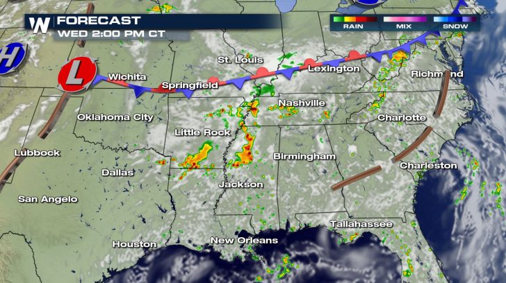
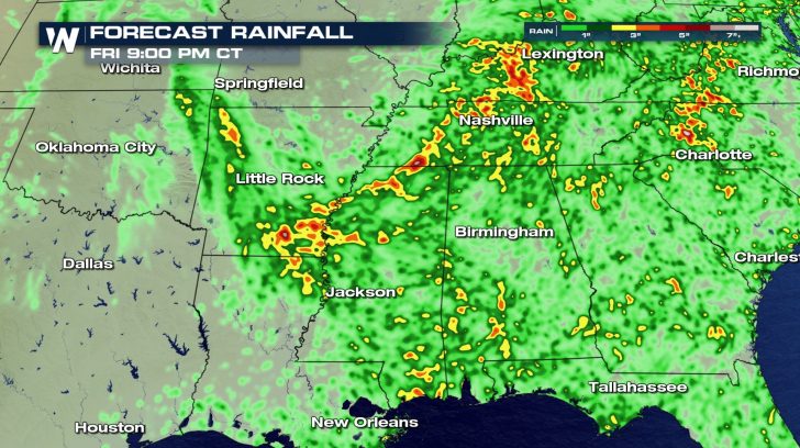
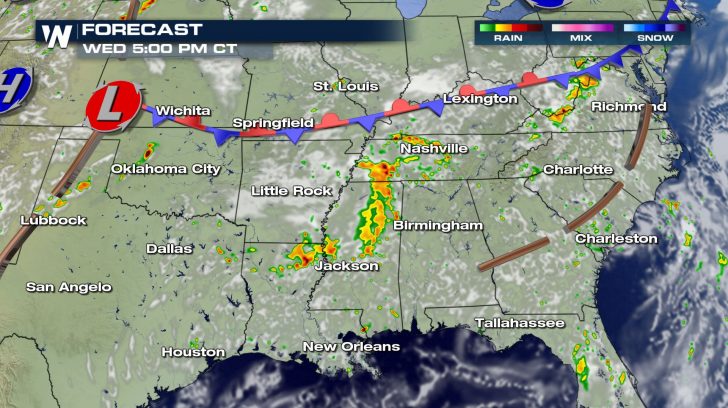 Additional rounds of slow-moving showers and thunderstorms may produce widespread 1 to 2 inch rainfall totals. Localized amounts up to 6 inches will be possible.
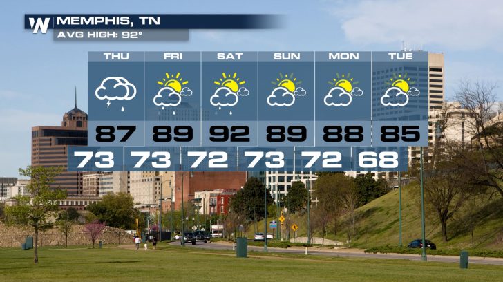
 Cities like Texarkana, St. Louis, and Memphis---among many others---will want to keep it tuned to WeatherNation for the latest forecast.
 Follow WeatherNation on Twitter and Facebook for more information.
Flash Flooding was also a concern in St. Louis, Missouri on Wednesday. Storm drains could not handle the amount of rain that fell in a short amount of time. Numerous roads were submerged in water.
https://twitter.com/FMtheWeatherman/status/1293574395353542662
Stranded vehicles and motorists were a common site throughout the city of St. Louis and surrounding suburbs in Missouri and Illinois.
https://twitter.com/LeonWhitener3/status/1293574128117649414
Looking ahead, the threat of heavy rain will linger, thanks to a stationary front that will remain across the region at least through Friday.
Additional rounds of slow-moving showers and thunderstorms may produce widespread 1 to 2 inch rainfall totals. Localized amounts up to 6 inches will be possible.
Cities like Texarkana, St. Louis, and Memphis---among many others---will want to keep it tuned to WeatherNation for the latest forecast.
Follow WeatherNation on Twitter and Facebook for more information.All Weather News
More
Fronts Continue To Spark Severe Weather Across the Plains
A cold front that brought record lows to the
18 Jul 2025 10:40 PM

Extreme Heat Impacts for the East Coast & South
Extreme heat continues to impact several area
18 Jul 2025 10:05 PM

Flooding Threat Remains Elevated in the East
A cold front pushing through the Eastern Seab
18 Jul 2025 9:10 PM

EF-2 Firenado from the Deer Creek Fire in Utah
A fire tornado was spotted near La Sal, Utah
18 Jul 2025 7:30 AM

Tropical System Brings Flood Risk to the Central Gulf
Time has run out for notable tropical develop
18 Jul 2025 3:05 AM

Heavy Rain, Flooding Threat Returns to Florida
Keep the rain boots handy in Florida - heavy
13 Jul 2025 12:50 PM

Severe Storm Risk Pushes into the Great Lakes, Ohio Valley
Friday was another busy day with severe weath
12 Jul 2025 8:00 PM