NASA Balloon Mission Captures Electric Blue Clouds
Special Stories
27 Sep 2018 8:39 AM
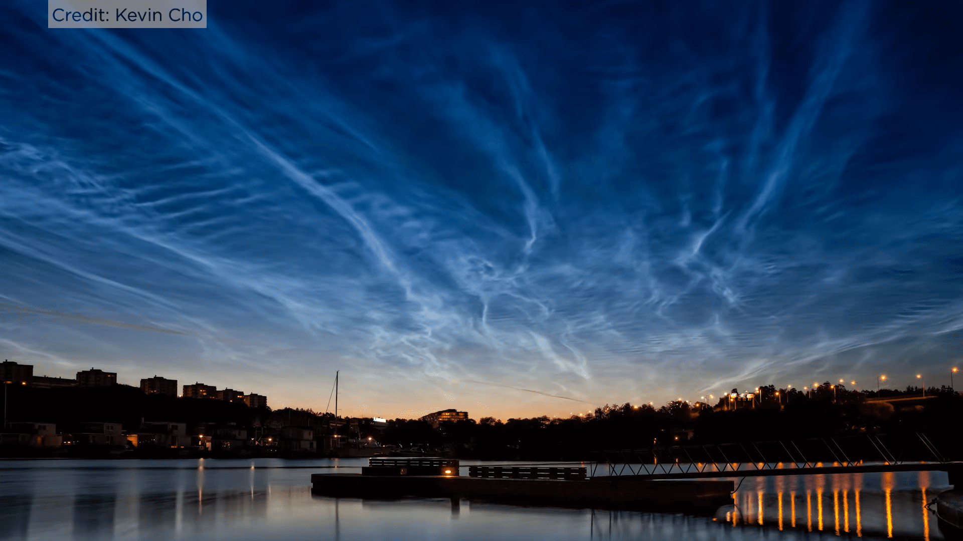
[Polar mesospheric clouds/electric blue clouds. Credit: Kevin Cho via NASA]
[NASA] On the cusp of our atmosphere live a thin group of seasonal electric blue clouds. Forming 50 miles above the poles in summer, these clouds are known as noctilucent clouds or polar mesospheric clouds — PMCs. A recent NASA long-duration balloon mission observed these clouds over the course of five days at their home in the mesosphere. The resulting photos, which scientists have just begun to analyze, will help us better understand turbulence in the atmosphere, as well as in oceans, lakes and other planetary atmospheres, and may even improve weather forecasting.
On July 8, 2018, NASA’s PMC Turbo mission launched a giant balloon to study PMCs at a height of 50 miles above the surface. For five days, the balloon floated through the stratosphere from its launch at Esrange, Sweden, across the Arctic to Western Nunavut, Canada. During its flight, cameras aboard the balloon captured 6 million high-resolution images filling up 120 terabytes of data storage — most of which included a variety of PMC displays, revealing the processes leading to turbulence. Scientists are now beginning to go through the images and the first look has been promising.
“From what we’ve seen so far, we expect to have a really spectacular dataset from this mission,” said Dave Fritts, principal investigator of the PMC Turbo mission at Global Atmospheric Technologies and Sciences in Boulder, Colorado. “Our cameras were likely able to capture some really interesting events and we hope will provide new insights into these complex dynamics.”
https://www.youtube.com/watch?v=NWb5SF8hFyE
Noctilucent clouds coalesce as ice crystals on tiny meteor remnants in the upper atmosphere. The results make brilliant blue rippling clouds that are visible just after the Sun sets in polar regions during the summer. These clouds are affected by what’s known as atmospheric gravity waves — caused by the convecting and uplifting of air masses, such as when air is pushed up by mountain ranges. The waves play major roles in transferring energy from the lower atmosphere to the mesosphere.
“This is the first time we’ve been able to visualize the flow of energy from larger gravity waves to smaller flow instabilities and turbulence in the upper atmosphere,” Fritts said. “At these altitudes you can literally see the gravity waves breaking — like ocean waves on the beach — and cascading to turbulence.”
The PMC Turbo balloon payload was equipped with seven specially designed imaging systems to observe the clouds. Each included a high-resolution camera, a computer control and communications system, and 32 terabytes of data storage. The seven imaging systems were arranged to create a mosaic of wide views extending one hundred miles across, with each narrow views able to image turbulence features as small as 20 yards wide. For the first time, a lidar — or laser radar — measured the precise altitudes of the PMCs as well as the temperature fluctuations of the gravity waves above and below the PMCs.
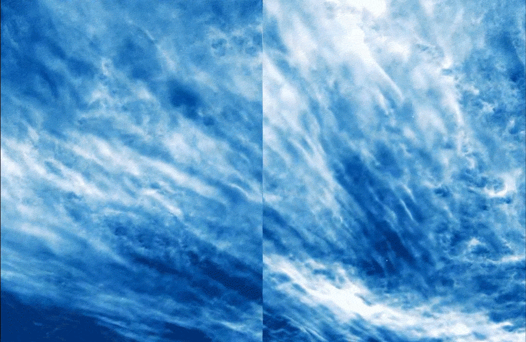 [Polar mesospheric clouds observed by NASA’s PMC Turbo mission as it flew over the Arctic in July 2018. Credit: NASA/PMC Turbo/Joy Ng]
“We know the 2D wave structure from the images, but in order to fully describe the waves we need to measure the third dimension as well,” said Bernd Kaifler, the researcher at the German Aerospace Center, in Wessling, Germany, who designed the balloon’s lidar experiment. “From the lidar measurements, we can infer the vertical structure of the waves, thus providing important data which would have not been available from the imaging experiment alone.”
Learning about the causes and effects of turbulence will help scientists understand not only the structure and variability of the upper atmosphere, but other areas as well. Turbulence occurs in fluids across the universe and the results will help scientists better model it in all systems. Ultimately, the results will even help improve weather forecast models.
Understanding a wide range of processes in near-Earth space — including how they interact with Earth’s atmosphere and weather — is a key part of NASA’s heliophysics research, which employs a full squad of satellites and sub-orbital instruments to observe different phenomena from different perspectives. NASA also studies noctilucent clouds with the Aeronomy of Ice in the Mesosphere, or AIM, spacecraft, which launched in 2007 into a low-Earth orbit. AIM tracks large scale features in the clouds across a global scale, but can only resolve features a couple miles across. PMC Turbo helps fill in the details, explaining what happens at smaller scales where turbulence occurs.
[Polar mesospheric clouds observed by NASA’s PMC Turbo mission as it flew over the Arctic in July 2018. Credit: NASA/PMC Turbo/Joy Ng]
“We know the 2D wave structure from the images, but in order to fully describe the waves we need to measure the third dimension as well,” said Bernd Kaifler, the researcher at the German Aerospace Center, in Wessling, Germany, who designed the balloon’s lidar experiment. “From the lidar measurements, we can infer the vertical structure of the waves, thus providing important data which would have not been available from the imaging experiment alone.”
Learning about the causes and effects of turbulence will help scientists understand not only the structure and variability of the upper atmosphere, but other areas as well. Turbulence occurs in fluids across the universe and the results will help scientists better model it in all systems. Ultimately, the results will even help improve weather forecast models.
Understanding a wide range of processes in near-Earth space — including how they interact with Earth’s atmosphere and weather — is a key part of NASA’s heliophysics research, which employs a full squad of satellites and sub-orbital instruments to observe different phenomena from different perspectives. NASA also studies noctilucent clouds with the Aeronomy of Ice in the Mesosphere, or AIM, spacecraft, which launched in 2007 into a low-Earth orbit. AIM tracks large scale features in the clouds across a global scale, but can only resolve features a couple miles across. PMC Turbo helps fill in the details, explaining what happens at smaller scales where turbulence occurs.
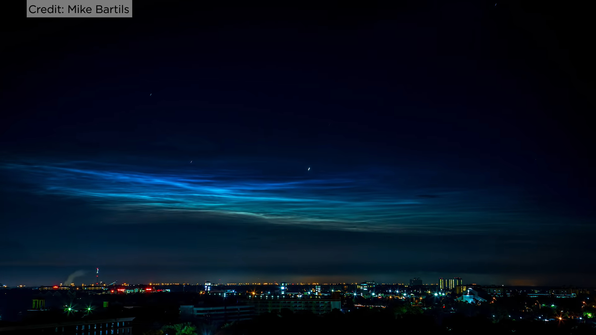 [Polar mesospheric clouds/electric blue clouds. Credit: Mike Bartils via NASA]
The PMC Turbo payload was successfully recovered from its landing site in the Canadian Arctic and the recovered instruments are expected to contribute to future missions, including one anticipated to fly next December over Antarctica.
[Polar mesospheric clouds/electric blue clouds. Credit: Mike Bartils via NASA]
The PMC Turbo payload was successfully recovered from its landing site in the Canadian Arctic and the recovered instruments are expected to contribute to future missions, including one anticipated to fly next December over Antarctica.
[Polar mesospheric clouds observed by NASA’s PMC Turbo mission as it flew over the Arctic in July 2018. Credit: NASA/PMC Turbo/Joy Ng]
“We know the 2D wave structure from the images, but in order to fully describe the waves we need to measure the third dimension as well,” said Bernd Kaifler, the researcher at the German Aerospace Center, in Wessling, Germany, who designed the balloon’s lidar experiment. “From the lidar measurements, we can infer the vertical structure of the waves, thus providing important data which would have not been available from the imaging experiment alone.”
Learning about the causes and effects of turbulence will help scientists understand not only the structure and variability of the upper atmosphere, but other areas as well. Turbulence occurs in fluids across the universe and the results will help scientists better model it in all systems. Ultimately, the results will even help improve weather forecast models.
Understanding a wide range of processes in near-Earth space — including how they interact with Earth’s atmosphere and weather — is a key part of NASA’s heliophysics research, which employs a full squad of satellites and sub-orbital instruments to observe different phenomena from different perspectives. NASA also studies noctilucent clouds with the Aeronomy of Ice in the Mesosphere, or AIM, spacecraft, which launched in 2007 into a low-Earth orbit. AIM tracks large scale features in the clouds across a global scale, but can only resolve features a couple miles across. PMC Turbo helps fill in the details, explaining what happens at smaller scales where turbulence occurs.
[Polar mesospheric clouds/electric blue clouds. Credit: Mike Bartils via NASA]
The PMC Turbo payload was successfully recovered from its landing site in the Canadian Arctic and the recovered instruments are expected to contribute to future missions, including one anticipated to fly next December over Antarctica.
NASA’s Goddard Space Flight Center’s Wallops Flight Facility in Virginia manages the agency’s scientific balloon flight program with 10 to 15 flights each year from launch sites worldwide.
Edited for WeatherNation by Meteorologist Mace Michaels
All Weather News
More


Severe Storms Target the Midwest to the Northeast This Week
Extreme heat will be a big story this week ac
27 Jul 2026 9:50 AM

Tropics: Fausto Heads to Hawaii; Genevieve Rapidly Intensifying
Atlantic BasinBertha has dissipated after mov
27 Jul 2026 1:40 AM

Southeast Flood Risk Lingers Near Stalled Front
A stalled boundary over the Southeast will ke
25 Jul 2026 10:55 AM

Another Round of Storms Targets the Northeast
Tuesday brought severe weather again across p
23 Jul 2026 1:15 AM

Another Round of Severe Weather for the Upper Midwest and Great Lakes
The upper-level low train continues to keep t
21 Jul 2026 1:45 AM