NASA Mapping Hurricane Damage to Everglades, Puerto Rico Forests
Special Stories
17 Apr 2018 9:10 AM
[Using data from the G-LiHT instrument flown over a 3 square mile (8 square kilometer) region of the Everglades, scientists calculated that Hurricane Irma heavily (orange) or severely (red) damaged 60 percent of the measured mangrove forest. From NASA]
From NASA
Last spring, NASA researchers flew over the Everglades and Puerto Rico to measure how mangroves and rainforests grow and evolve over time. Five months later, hurricanes Irma and Maria tore through those study areas – creating a unique opportunity to investigate the devastating effects of massive storms on these ecosystems, as well as their gradual recovery.
Flying the same paths over the Everglades three months after Hurricane Irma, the scientists’ preliminary findings reveal that 60 percent of the mangrove forests analyzed were heavily or severely damaged. Next week, the team will return to Puerto Rico to conduct an airborne survey of the rainforest there – quantifying the damage and possibly identifying sites vulnerable to landslides.
The view of southeastern Florida, less than three months after Hurricane Irma hit, revealed swaths of leafless trees and broken branches, even uprooted mangrove trees.
“It’s staggering how much was lost. The question is, which areas will regrow and which areas won’t,” said Lola Fatoyinbo, a remote sensing scientist at NASA’s Goddard Space Flight Center in Greenbelt, Maryland and the Florida project’s principal investigator. “This is an opportunity -- with all these data, we can really make a difference in understanding how hurricanes impact Florida’s mangrove ecosystems.”
 [Researchers used laser and stereoscopic instruments to collect 3D information of hurricane-damaged mangrove forests from the ground as well as from planes. Here, a ground-based lidar captures researchers within a mangrove forest in Ten Thousand Islands in southwest Florida, displaying much finer detail on the ground than available from the air. Credits: NASA]
A team of scientists worked with local land managers, including the Everglades National Park and Florida Fish and Wildlife, to plan and execute data-collecting flights in April 2017 for a scientific instrument called Goddard’s Lidar, Hyperspectral and Thermal Imager, or G-LiHT.G-LiHT collects multiple measurements simultaneously, including the heights of the vegetation from a lidar instrument, and high-resolution photographs.
“We had this amazing dataset – then the hurricane went through,” Lagomasino said. Hurricane Irma, with winds upwards of 140 miles per hour (225 kilometers per hour), swept through the Everglades National Park on Sept. 10, 2017. “Hurricanes are a natural part of the ecosystem, and we know that after hurricanes the ecosystem does return for the most part. But not a hundred percent.” Areas without surviving or regrowing mangrove trees may put neighboring ecosystems at risk of additional impacts from storm surges and saltwater intrusion.
After the team reflew the same paths across 500 square miles (1,300 square km) of wetlands, a preliminary analysis of the two sets of flights found that gaps in the canopy from snapped branches and uprooted trees covered 40 percent of the area. In areas hit the hardest, the height measurements from G-LiHT showed that the average height of the forest canopy was shortened by 3 to 5 feet (1 to 1.5 meters) due to fallen branches and trees.
The researchers also joined scientists from local agencies and organizations to measure the hurricane impact from the ground. Hiking into the wetlands, they used laser scanners to take three-dimensional images of the trees, branches and even leaves that make up the forest structure.
“The number of downed trees, just completely splintered in some cases, was impressive to see,” said Lagomasino.
[Researchers used laser and stereoscopic instruments to collect 3D information of hurricane-damaged mangrove forests from the ground as well as from planes. Here, a ground-based lidar captures researchers within a mangrove forest in Ten Thousand Islands in southwest Florida, displaying much finer detail on the ground than available from the air. Credits: NASA]
A team of scientists worked with local land managers, including the Everglades National Park and Florida Fish and Wildlife, to plan and execute data-collecting flights in April 2017 for a scientific instrument called Goddard’s Lidar, Hyperspectral and Thermal Imager, or G-LiHT.G-LiHT collects multiple measurements simultaneously, including the heights of the vegetation from a lidar instrument, and high-resolution photographs.
“We had this amazing dataset – then the hurricane went through,” Lagomasino said. Hurricane Irma, with winds upwards of 140 miles per hour (225 kilometers per hour), swept through the Everglades National Park on Sept. 10, 2017. “Hurricanes are a natural part of the ecosystem, and we know that after hurricanes the ecosystem does return for the most part. But not a hundred percent.” Areas without surviving or regrowing mangrove trees may put neighboring ecosystems at risk of additional impacts from storm surges and saltwater intrusion.
After the team reflew the same paths across 500 square miles (1,300 square km) of wetlands, a preliminary analysis of the two sets of flights found that gaps in the canopy from snapped branches and uprooted trees covered 40 percent of the area. In areas hit the hardest, the height measurements from G-LiHT showed that the average height of the forest canopy was shortened by 3 to 5 feet (1 to 1.5 meters) due to fallen branches and trees.
The researchers also joined scientists from local agencies and organizations to measure the hurricane impact from the ground. Hiking into the wetlands, they used laser scanners to take three-dimensional images of the trees, branches and even leaves that make up the forest structure.
“The number of downed trees, just completely splintered in some cases, was impressive to see,” said Lagomasino.
[Damage to the Florida Everglades is seen from the air, as the G-LiHT team captured images of the same mangrove ecosystem of Ten Thousand Islands before (March 28, 2017 on top) and after (Dec. 1, 2017 on bottom) Hurricane Irma. Credits: NASA]
The South Florida project started with a question about how freshwater ecosystems, such as sawgrass marshes of the Everglades, are transitioning to saltwater ecosystems. This change, which can result from rising sea level and coastal erosion, can impact the local soil microbes, vegetation and even the aquifers Miami draws on for its drinking water.
The scientists have been using data from the Landsat satellites to measure the extent of hurricane damage to the forests over the last 30 years. The Landsat imagery not only provides information about the extent of the damage, but also the time it takes the forest to recover. At the same time the satellite imagery can also identify areas where vulnerable forests were replaced with open water.
“We want to know how fast this transition is happening. Combining the spatial changes measured by satellite with the structural information we measure from the air we can estimate where the key habitats are that are most vulnerable to hurricanes and saltwater intrusion,” said David Lagomasino, a remote sensing scientist at Goddard.
[Researchers used laser and stereoscopic instruments to collect 3D information of hurricane-damaged mangrove forests from the ground as well as from planes. Here, a ground-based lidar captures researchers within a mangrove forest in Ten Thousand Islands in southwest Florida, displaying much finer detail on the ground than available from the air. Credits: NASA]
A team of scientists worked with local land managers, including the Everglades National Park and Florida Fish and Wildlife, to plan and execute data-collecting flights in April 2017 for a scientific instrument called Goddard’s Lidar, Hyperspectral and Thermal Imager, or G-LiHT.G-LiHT collects multiple measurements simultaneously, including the heights of the vegetation from a lidar instrument, and high-resolution photographs.
“We had this amazing dataset – then the hurricane went through,” Lagomasino said. Hurricane Irma, with winds upwards of 140 miles per hour (225 kilometers per hour), swept through the Everglades National Park on Sept. 10, 2017. “Hurricanes are a natural part of the ecosystem, and we know that after hurricanes the ecosystem does return for the most part. But not a hundred percent.” Areas without surviving or regrowing mangrove trees may put neighboring ecosystems at risk of additional impacts from storm surges and saltwater intrusion.
After the team reflew the same paths across 500 square miles (1,300 square km) of wetlands, a preliminary analysis of the two sets of flights found that gaps in the canopy from snapped branches and uprooted trees covered 40 percent of the area. In areas hit the hardest, the height measurements from G-LiHT showed that the average height of the forest canopy was shortened by 3 to 5 feet (1 to 1.5 meters) due to fallen branches and trees.
The researchers also joined scientists from local agencies and organizations to measure the hurricane impact from the ground. Hiking into the wetlands, they used laser scanners to take three-dimensional images of the trees, branches and even leaves that make up the forest structure.
“The number of downed trees, just completely splintered in some cases, was impressive to see,” said Lagomasino.
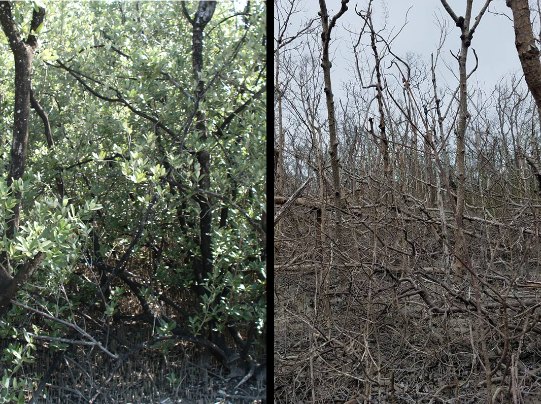
[More than four months after Hurricane Irma, some mangrove forests were still lacking leaves and new growth. On the left, a healthy mangrove forest in 2000, on the right, damaged hurricane-damaged mangroves in January 2018. Credits: Credit: USGS/Tracy Enright, left, and NASA/David Lagomasino, right]
The team now plans to compare datasets from before and after the hurricane to see if the areas that were under stress before the storm – whether from saltwater encroachment, nearby developments, or other reasons – correspond with the areas that don’t recover as quickly, or don’t recover at all. Lagomasino would also like to look for other damage patterns and estimate tree mortality. Collectively, the G-LiHT data will help provide a better understanding of the vulnerability of Florida’s coastal ecosystems to storms.
“There’s so much data, and we’re trying to see now what could give us important information about the landscape before we head into the next hurricane season,” Lagomasino said. “There’s a lot to do.”
The store of post-hurricane data – all free and available to the public – is about to grow. G-LiHT flights over Puerto Rico, which was hit by both Hurricane Irma and the Category 4 Hurricane Maria on Sept. 20, are scheduled to start next week.
The team will fly the same flight paths they surveyed in March 2017, with some additional routes designed to gather data over landslides and other sites of interest. As they did in Florida, they’ll work with local ecologists and forest managers to tie what they measure from the air with what they measure from the ground.
“It’s a good way to document which areas were more susceptible to events like Hurricane Maria,” said Bruce Cook, G-LiHT’s lead scientist at NASA Goddard. “And also it’s a way to start tracking recovery as well. A lot of people are interested in the recovery, and what we might be talking about in terms of reestablishing the forests in the future, and whether it will require human intervention.”
Edited for WeatherNation by Meteorologist Mace MichaelsAll Weather News
More
Fronts Continue To Spark Severe Weather Across the Plains
A cold front that brought record lows to the
18 Jul 2025 10:40 PM

Extreme Heat Impacts for the East Coast & South
Extreme heat continues to impact several area
18 Jul 2025 10:05 PM

Flooding Threat Remains Elevated in the East
A cold front pushing through the Eastern Seab
18 Jul 2025 9:10 PM

EF-2 Firenado from the Deer Creek Fire in Utah
A fire tornado was spotted near La Sal, Utah
18 Jul 2025 7:30 AM

Tropical System Brings Flood Risk to the Central Gulf
Time has run out for notable tropical develop
18 Jul 2025 3:05 AM

Heavy Rain, Flooding Threat Returns to Florida
Keep the rain boots handy in Florida - heavy
13 Jul 2025 12:50 PM

Severe Storm Risk Pushes into the Great Lakes, Ohio Valley
Friday was another busy day with severe weath
12 Jul 2025 8:00 PM