New Data Product Offers a More Complete Picture of Storms
Special Stories
6 Jan 2021 1:00 AM
[From NOAA NSSL by Emily Summars] Researchers are excited to announce the release of a new, extensive data product that combines a multitude of data sources to help researchers, forecasters, and weather enthusiasts.
The Multi-Year Reanalysis of Remotely Sensed Storms Project, or MYRORSS, combines individual radar data with other sources, like weather models and lightning data, for a more complete picture of storms. MYRORSS data is high-resolution, three-dimensional, and updates more rapidly, unlike some two-dimensional data sets. Created by researchers and students at the Cooperative Institute for Mesoscale Meteorological Studies and NOAA National Severe Storms Laboratory, MYRORSS provides scientists the capability to create new computer programs for storm analysis and climatologies, or storm climatology studies.
“Most storm climatologies are based on reports,” said Kiel Ortega, a researcher at CIMMS supporting NSSL. “Such reports can be biased based on where people live. With MYRORSS data, we can get a better idea, for example, where hail occurs and with what frequency.”
In addition, scientists may use the data in machine learning and artificial intelligence experiments to learn more about specific components and characteristics of severe weather. One example would be how tornado-producing storms may look different from storms that do not produce tornadoes.
CIMMS Researcher Vanna Chmielewski who is utilizing the product for her lightning research said the data combination in MYRORSS will make a big difference.
“A large time commitment to many studies is quality controlling the data and aligning different data sources,” Chmielewski said. “For a large statistical or machine learning project, it is also important to have uniformity in how that process is done, otherwise there could be some bias which shows up in the statistical model purely due to changes in how the process was done.
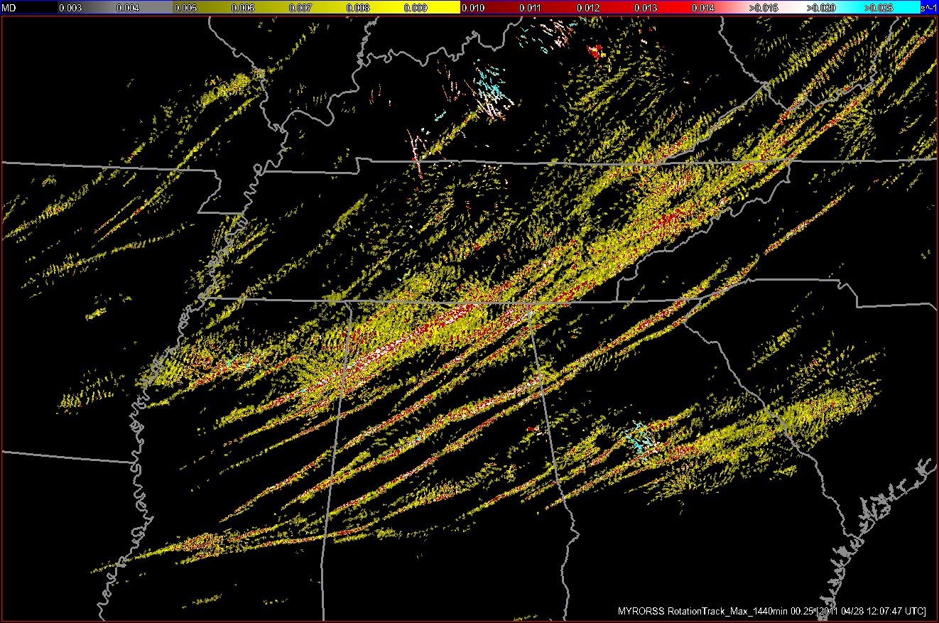 [This an accumulation of azimuthal shear, called rotation tracks, from a tornado outbreak on April 27, 2011. Researchers are using rotation track data in MYRORSS to identify rotating storms and to help with climatologies, like hail, as rotating storms can produce larger hail than non-rotating storms. (Screenshot provided by Kiel Ortega and Skylar Williams, OU CIMMS/NOAA NSSL)]
CIMMS Researcher Vanna Chmielewski who is utilizing the product for her lightning research said the data combination in MYRORSS will make a big difference.
“A large time commitment to many studies is quality controlling the data and aligning different data sources,” Chmielewski said. “For a large statistical or machine learning project, it is also important to have uniformity in how that process is done, otherwise there could be some bias which shows up in the statistical model purely due to changes in how the process was done.
“What has been done by the MYRORSS team is huge in building that base dataset over a large area and time period. This database really has infinite potential for future studies,” she said.
Several meteorological studies have sample sizes that are small, such as data from one field experiment or one severe weather season. Larger studies have often been limited in which data could be included due to time restrictions associated with quality control and other initial steps, Chmielewski explained.
“Having a dataset like this can really help improve science by allowing those larger studies to be more easily done,” she said.
Chmielewski plans to use MYRORSS data to study “bolts from the blue,” cloud-to-ground lightning flashes typically originating from the backside of a thunderstorm cloud. Such flashes can travel a large distance in clear air away from the storm cloud, angling down and striking the ground. She also intends to research answers to questions like, “how far can a flash of lightning strike from a storm?” with a larger data sample than previously available.
The MYRORSS database will allow researchers to tackle many atmospheric questions from over many years and across the country.
[This an accumulation of azimuthal shear, called rotation tracks, from a tornado outbreak on April 27, 2011. Researchers are using rotation track data in MYRORSS to identify rotating storms and to help with climatologies, like hail, as rotating storms can produce larger hail than non-rotating storms. (Screenshot provided by Kiel Ortega and Skylar Williams, OU CIMMS/NOAA NSSL)]
CIMMS Researcher Vanna Chmielewski who is utilizing the product for her lightning research said the data combination in MYRORSS will make a big difference.
“A large time commitment to many studies is quality controlling the data and aligning different data sources,” Chmielewski said. “For a large statistical or machine learning project, it is also important to have uniformity in how that process is done, otherwise there could be some bias which shows up in the statistical model purely due to changes in how the process was done.
“What has been done by the MYRORSS team is huge in building that base dataset over a large area and time period. This database really has infinite potential for future studies,” she said.
Several meteorological studies have sample sizes that are small, such as data from one field experiment or one severe weather season. Larger studies have often been limited in which data could be included due to time restrictions associated with quality control and other initial steps, Chmielewski explained.
“Having a dataset like this can really help improve science by allowing those larger studies to be more easily done,” she said.
Chmielewski plans to use MYRORSS data to study “bolts from the blue,” cloud-to-ground lightning flashes typically originating from the backside of a thunderstorm cloud. Such flashes can travel a large distance in clear air away from the storm cloud, angling down and striking the ground. She also intends to research answers to questions like, “how far can a flash of lightning strike from a storm?” with a larger data sample than previously available.
The MYRORSS database will allow researchers to tackle many atmospheric questions from over many years and across the country.
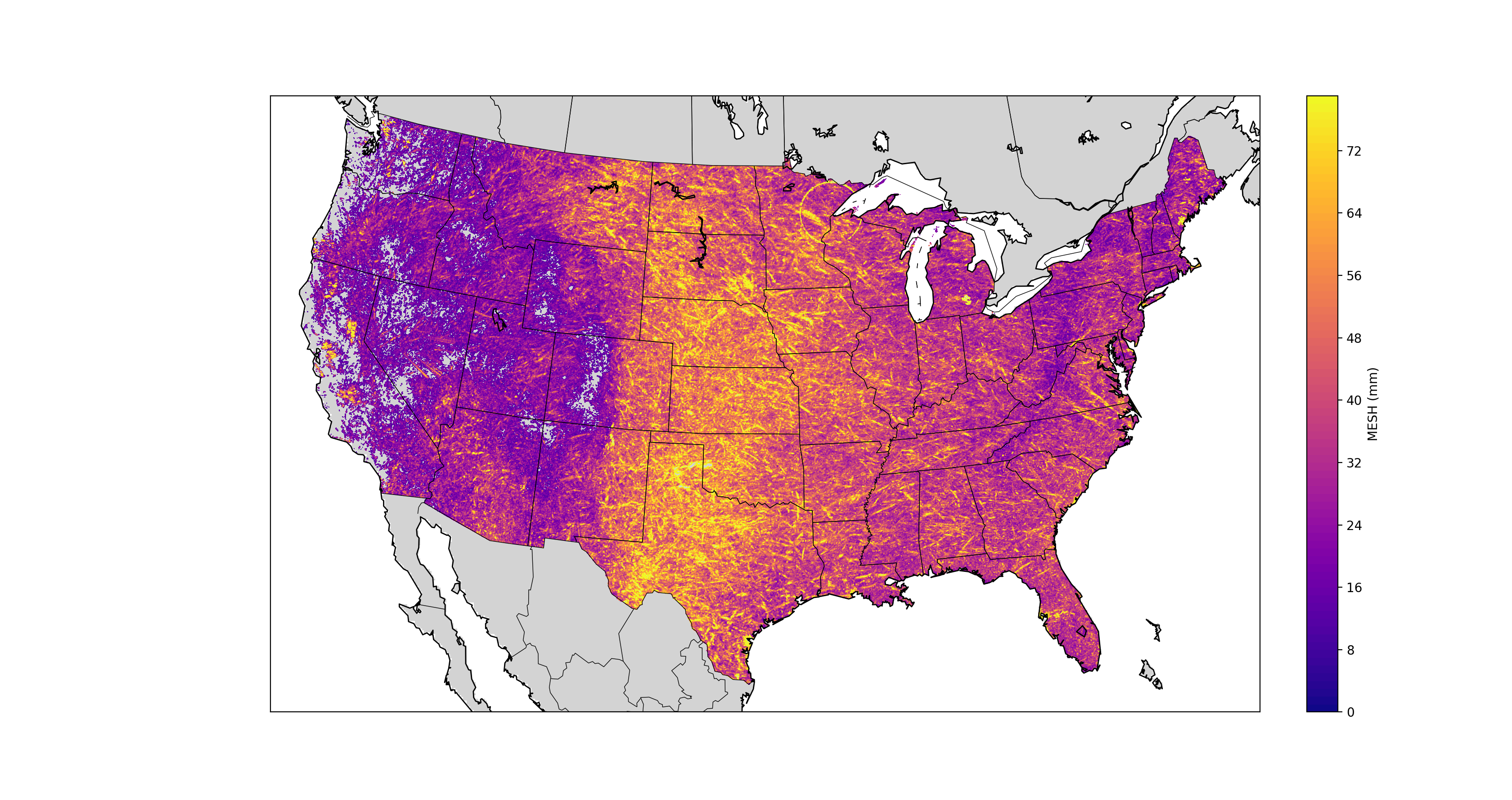 [The Multi-Year Reanalysis of Remotely Sensed Storms Project, or MYRORSS combines individual radar data with other sources, like weather models and lightning data, for a more complete picture of storms. Image from OU CIMMS]
For Chmielewski, this presents new opportunities.
“Are bolt from the blue flashes more common in some parts of the country than others? Has that changed with time? Can we find reasons why some storms do and others don’t? These sorts of questions are really hard to answer without a base dataset like MYRORSS, and the MYRORSS group has done a great job bringing these storm and environmental variables together into a single, quality-controlled dataset,” she said.
MYRORSS began in 2012 and utilizes the Multi-Radar Multi-Sensor framework, along with many other data sources. Students made this project possible as they combed through terabytes of data. Guided by researchers from CIMMS at the University of Oklahoma and NSSL, students processed the data required for MYRORSS while conducting extensive quality control. The NOAA National Centers for Environmental Information also assisted with some of the data processing.
“MYRORSS was my first experience with research as a student and helped me determine my path in the field,” said Skylar Williams, CIMMS researcher supporting NSSL.
Williams finished her master’s degree and was hired full-time at CIMMS, continuing her work on MYRORSS. She is excited to share the product with others after years of work.
“The processing was time-consuming— even with more than 15 machines — and because of the extensive quality control, anytime we found bad data we would actually have to go back and reprocess that entire day,” Williams said. “When dealing with 14 years of data, reprocessing that added up. However, reprocessing allowed us to create a great product with good data for anyone to use.” You can learn more about MYRORSS and view the data here.
Edited for WeatherNation by Mace Michaels
[The Multi-Year Reanalysis of Remotely Sensed Storms Project, or MYRORSS combines individual radar data with other sources, like weather models and lightning data, for a more complete picture of storms. Image from OU CIMMS]
For Chmielewski, this presents new opportunities.
“Are bolt from the blue flashes more common in some parts of the country than others? Has that changed with time? Can we find reasons why some storms do and others don’t? These sorts of questions are really hard to answer without a base dataset like MYRORSS, and the MYRORSS group has done a great job bringing these storm and environmental variables together into a single, quality-controlled dataset,” she said.
MYRORSS began in 2012 and utilizes the Multi-Radar Multi-Sensor framework, along with many other data sources. Students made this project possible as they combed through terabytes of data. Guided by researchers from CIMMS at the University of Oklahoma and NSSL, students processed the data required for MYRORSS while conducting extensive quality control. The NOAA National Centers for Environmental Information also assisted with some of the data processing.
“MYRORSS was my first experience with research as a student and helped me determine my path in the field,” said Skylar Williams, CIMMS researcher supporting NSSL.
Williams finished her master’s degree and was hired full-time at CIMMS, continuing her work on MYRORSS. She is excited to share the product with others after years of work.
“The processing was time-consuming— even with more than 15 machines — and because of the extensive quality control, anytime we found bad data we would actually have to go back and reprocess that entire day,” Williams said. “When dealing with 14 years of data, reprocessing that added up. However, reprocessing allowed us to create a great product with good data for anyone to use.” You can learn more about MYRORSS and view the data here.
Edited for WeatherNation by Mace Michaels
[This an accumulation of azimuthal shear, called rotation tracks, from a tornado outbreak on April 27, 2011. Researchers are using rotation track data in MYRORSS to identify rotating storms and to help with climatologies, like hail, as rotating storms can produce larger hail than non-rotating storms. (Screenshot provided by Kiel Ortega and Skylar Williams, OU CIMMS/NOAA NSSL)]
CIMMS Researcher Vanna Chmielewski who is utilizing the product for her lightning research said the data combination in MYRORSS will make a big difference.
“A large time commitment to many studies is quality controlling the data and aligning different data sources,” Chmielewski said. “For a large statistical or machine learning project, it is also important to have uniformity in how that process is done, otherwise there could be some bias which shows up in the statistical model purely due to changes in how the process was done.
“What has been done by the MYRORSS team is huge in building that base dataset over a large area and time period. This database really has infinite potential for future studies,” she said.
Several meteorological studies have sample sizes that are small, such as data from one field experiment or one severe weather season. Larger studies have often been limited in which data could be included due to time restrictions associated with quality control and other initial steps, Chmielewski explained.
“Having a dataset like this can really help improve science by allowing those larger studies to be more easily done,” she said.
Chmielewski plans to use MYRORSS data to study “bolts from the blue,” cloud-to-ground lightning flashes typically originating from the backside of a thunderstorm cloud. Such flashes can travel a large distance in clear air away from the storm cloud, angling down and striking the ground. She also intends to research answers to questions like, “how far can a flash of lightning strike from a storm?” with a larger data sample than previously available.
The MYRORSS database will allow researchers to tackle many atmospheric questions from over many years and across the country.
[The Multi-Year Reanalysis of Remotely Sensed Storms Project, or MYRORSS combines individual radar data with other sources, like weather models and lightning data, for a more complete picture of storms. Image from OU CIMMS]
For Chmielewski, this presents new opportunities.
“Are bolt from the blue flashes more common in some parts of the country than others? Has that changed with time? Can we find reasons why some storms do and others don’t? These sorts of questions are really hard to answer without a base dataset like MYRORSS, and the MYRORSS group has done a great job bringing these storm and environmental variables together into a single, quality-controlled dataset,” she said.
MYRORSS began in 2012 and utilizes the Multi-Radar Multi-Sensor framework, along with many other data sources. Students made this project possible as they combed through terabytes of data. Guided by researchers from CIMMS at the University of Oklahoma and NSSL, students processed the data required for MYRORSS while conducting extensive quality control. The NOAA National Centers for Environmental Information also assisted with some of the data processing.
“MYRORSS was my first experience with research as a student and helped me determine my path in the field,” said Skylar Williams, CIMMS researcher supporting NSSL.
Williams finished her master’s degree and was hired full-time at CIMMS, continuing her work on MYRORSS. She is excited to share the product with others after years of work.
“The processing was time-consuming— even with more than 15 machines — and because of the extensive quality control, anytime we found bad data we would actually have to go back and reprocess that entire day,” Williams said. “When dealing with 14 years of data, reprocessing that added up. However, reprocessing allowed us to create a great product with good data for anyone to use.” You can learn more about MYRORSS and view the data here.
Edited for WeatherNation by Mace MichaelsAll Weather News
More
SW Low Moves East, Brings Flood Threat to the Plains
A powerful low pressure system has been movin
24 Oct 2026 1:10 AM

Hurricane Vance Strengthens In The Pacific
After becoming a hurricane Friday, Vance quic
24 Oct 2026 1:00 AM

Warmer Than Average: Above-Normal Temperatures Across the Central U.S. This Week
WHAT TO EXPECTA ridge of high pressure linger
24 Oct 2026 12:50 AM


Several Fires Break Out in SoCal Last Week Amid Santa Ana Wind Event
Santa Ana winds helped several fires grow qui
19 Oct 2026 1:25 PM

Another Cold Morning Before Things Warm Back Up
Across portions of the Ohio Valley through th
19 Oct 2026 10:15 AM

Severe Risk Diminishing Saturday Morning for the Northeast
Severe Storm PotentialSevere risk is decreasi
16 Oct 2026 10:20 AM