New NOAA Report Looks at National Coastal Flood Vulnerability
Special Stories
20 Mar 2018 8:33 AM
From NOAA
NOAA scientists have demonstrated a new method to assess flood vulnerability in the United States on a national to regional level.
The report, spearheaded by sea level experts from NOAA’s Center for Operational Oceanographic Products and Services, looked at existing flood thresholds established by the National Weather Service and found patterns in the thresholds based upon tide range. They were then able to apply that pattern nationwide and find a statistical and consistent way to measure and monitor minor high tide flooding, as well as moderate and major flooding in locations where no threshold exists.
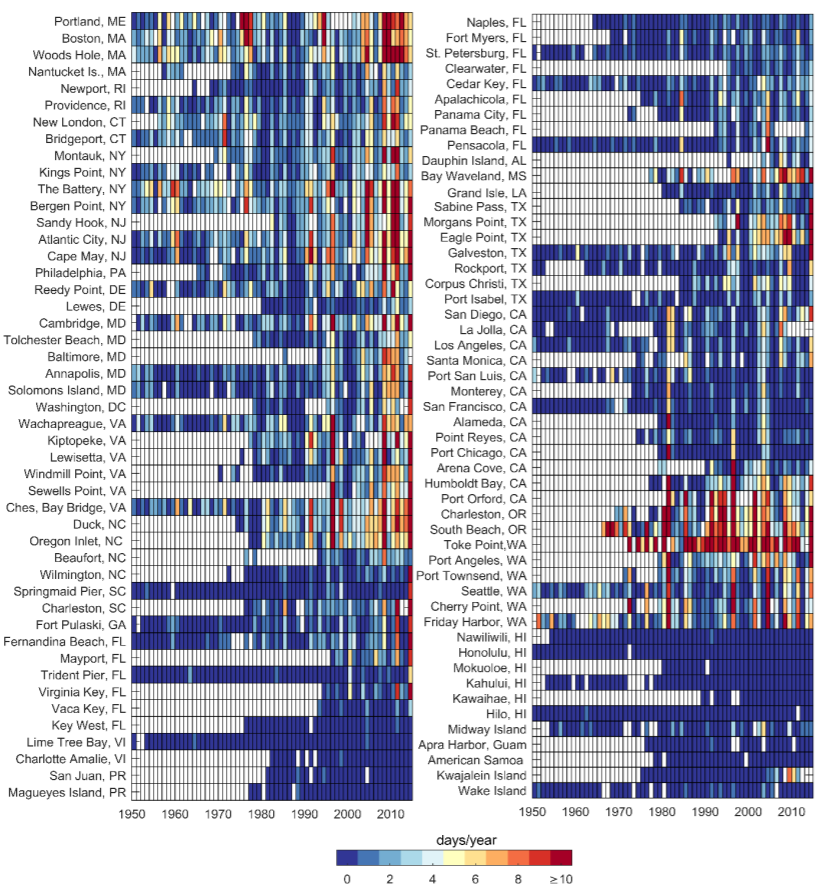 [Annual number of high tide floods (days per year) at NOAA tide gauge locations. A year is defined in
terms of a meteorological year (May–April). Note: White squares indicate no data or that hourly data was less than 80% complete within a year.]
The report finds that, on average, U.S. coastal infrastructure is vulnerable to minor, moderate, and major flooding at heights of about 1.6, 2.6, and 3.9 feet above the average daily highest tide (Mean Higher High Water). Trends in annual high tide flood frequencies are increasing or accelerating at two-thirds of the roughly 100 locations examined.
[Annual number of high tide floods (days per year) at NOAA tide gauge locations. A year is defined in
terms of a meteorological year (May–April). Note: White squares indicate no data or that hourly data was less than 80% complete within a year.]
The report finds that, on average, U.S. coastal infrastructure is vulnerable to minor, moderate, and major flooding at heights of about 1.6, 2.6, and 3.9 feet above the average daily highest tide (Mean Higher High Water). Trends in annual high tide flood frequencies are increasing or accelerating at two-thirds of the roughly 100 locations examined.
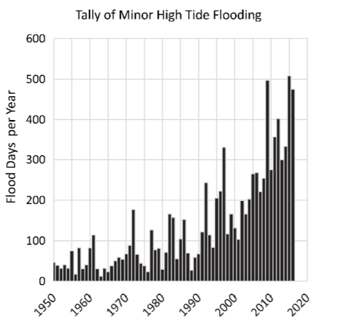 This science gives communities more information about their risk as they prepare for coastal flooding. With continued increases in regional sea level rise projected to occur, high tide flooding will become chronic in the next several decades.
Edited for WeatherNation by Meteorologist Mace Michaels
This science gives communities more information about their risk as they prepare for coastal flooding. With continued increases in regional sea level rise projected to occur, high tide flooding will become chronic in the next several decades.
Edited for WeatherNation by Meteorologist Mace Michaels
[Annual number of high tide floods (days per year) at NOAA tide gauge locations. A year is defined in
terms of a meteorological year (May–April). Note: White squares indicate no data or that hourly data was less than 80% complete within a year.]
The report finds that, on average, U.S. coastal infrastructure is vulnerable to minor, moderate, and major flooding at heights of about 1.6, 2.6, and 3.9 feet above the average daily highest tide (Mean Higher High Water). Trends in annual high tide flood frequencies are increasing or accelerating at two-thirds of the roughly 100 locations examined.
This science gives communities more information about their risk as they prepare for coastal flooding. With continued increases in regional sea level rise projected to occur, high tide flooding will become chronic in the next several decades.
Edited for WeatherNation by Meteorologist Mace MichaelsAll Weather News
More
Fronts Continue To Spark Severe Weather Across the Plains
A cold front that brought record lows to the
18 Jul 2025 10:40 PM

Extreme Heat Impacts for the East Coast & South
Extreme heat continues to impact several area
18 Jul 2025 10:05 PM

Flooding Threat Remains Elevated in the East
A cold front pushing through the Eastern Seab
18 Jul 2025 9:10 PM

EF-2 Firenado from the Deer Creek Fire in Utah
A fire tornado was spotted near La Sal, Utah
18 Jul 2025 7:30 AM

Tropical System Brings Flood Risk to the Central Gulf
Time has run out for notable tropical develop
18 Jul 2025 3:05 AM

Heavy Rain, Flooding Threat Returns to Florida
Keep the rain boots handy in Florida - heavy
13 Jul 2025 12:50 PM

Severe Storm Risk Pushes into the Great Lakes, Ohio Valley
Friday was another busy day with severe weath
12 Jul 2025 8:00 PM