The Next Big Thing: Coast-to-Coast Storm
Special Stories
17 Jan 2018 2:53 PM
Here we go again. A coast-to-coast storm system is brewing in the Pacific and will bring some big changes to the forecast through early next week. Keep in mind, the farther you go out in time, the more the forecast is likely to change. Here is a look at the possible scenario through the weekend:
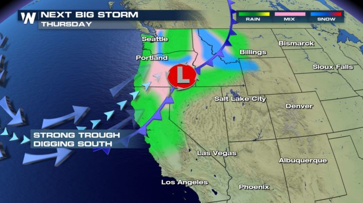 A trough of low pressure will begin digging south just off the west coast. Mid and upper level energy will help provide a broad sense of lift to make for a rainy pattern. Add in a surface low, sprawling cold front, and mountainous terrain and wide spread rain and snow showers will be possible. Watch out for some wintry mix at mid-elevations as it could become icy at times. Winter Weather Advisories are in place for parts of the Northern Rockies and Washington Cascades. Winter Storm Watches are popping up in Northern California for elevations above 3000 ft.
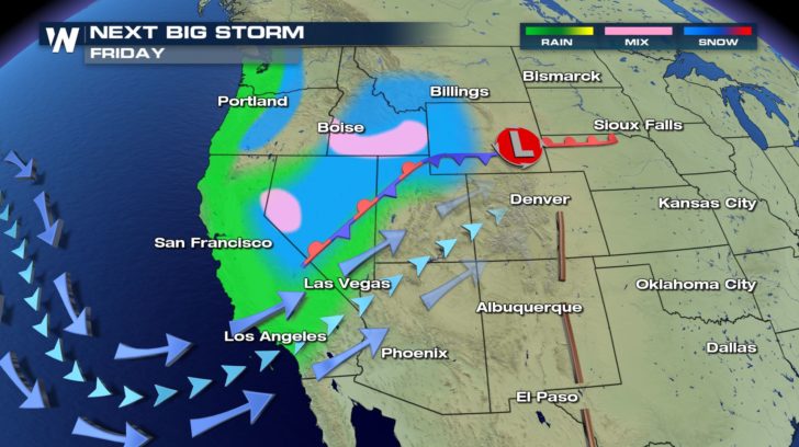 As the trough continues to dig south, so will precipitation chances. California and Nevada will see their best shot at rain/snow during the day. Wyoming and Utah will get in on the mountain snow, while the Snake River Valley in Idaho could be looking at a bit of wintry mix. Winds will be strong, making driving that much more difficult. Watch for advisories and warnings to expand.
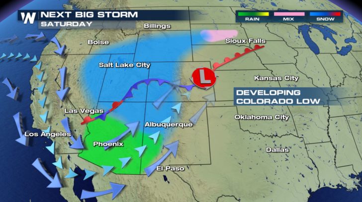 It's been a very dry season across the Four Corners region. This storm system could bring a chance of rain and snow to areas in pretty desperate need. As this system drops rain and snow from the northern to the southern Rockies, we're keeping an eye on the surface low that will deepen east of the mountains. As it strengthens and moves east, the storm's intensity could blow up into Sunday. This is when the track of the low has a huge impact. Keep checking in on our Top Weather Stories as the forecast updates.
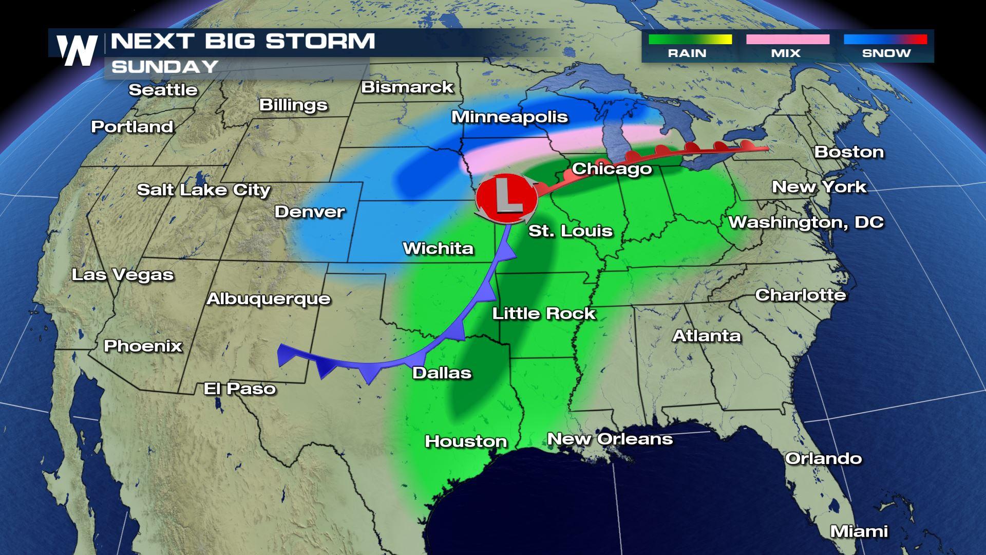
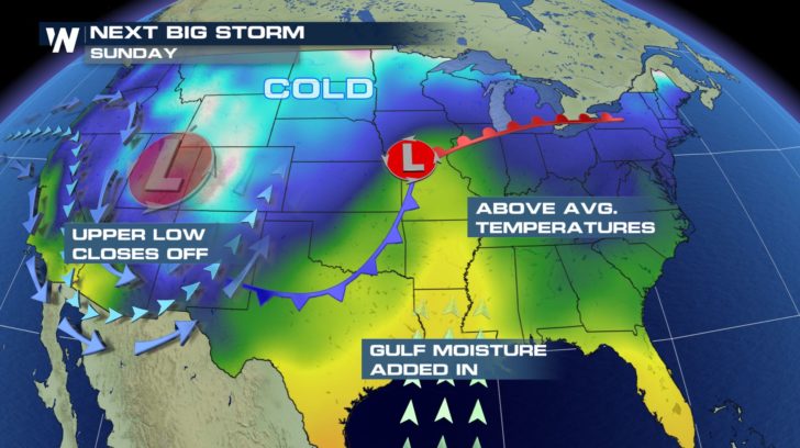 Sunday has the potential to be a pretty big day. In addition to the energy and development coming from the west, we'll add in moisture from the Gulf of Mexico and above average temperatures. This will help energize the system and possibly add on a severe weather component along the cold front.
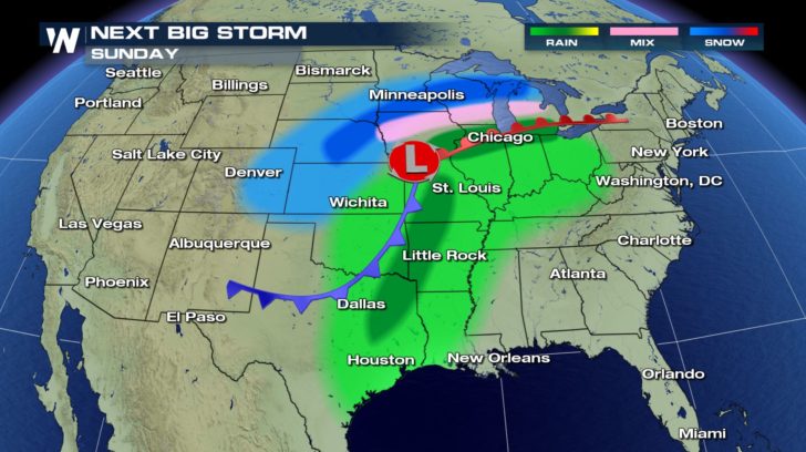 Heavy snow is also a possibility through the Upper Midwest. Gusty winds could create near blizzard conditions north of the low. Because of the warm air associated with this system, we could be looking at moderate rainfall as far north as the Great Lakes. Along the warm front, a mixed bag of rain, snow, sleet and freezing rain is possible. Keep in mind, once the low passes east, temperatures will drop quickly and precipitation type will change.
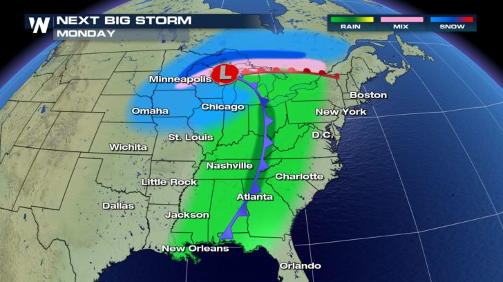 On Monday, the storm begins to wrap up in itself. The cold air starts catching up with the warm air and the system begins the slow process of weakening. It's still looking like heavy rain and a few thunderstorms are possible along the cold front, but the severe potential will be less than Sunday. The chance of wintry mix and icing will once again hug the warm front as the low slides east. The heaviest snow will fall just north of the transition line, with lighter snow wrapping around on the back side of the low.
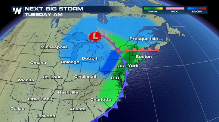 Late Monday into Tuesday, the storm system will work its way into the Mid-Atlantic and Northeastern states. A triple point (spot where the three fronts come together) develops and will trace the heaviest precipitation as it moves northeast. Heavy rain is possible on the warm side of the front, with heavy snow to follow behind. By Tuesday night, the worst of the precipitation should move out to sea.
For WeatherNation, Meteorologist Karissa Klos
Late Monday into Tuesday, the storm system will work its way into the Mid-Atlantic and Northeastern states. A triple point (spot where the three fronts come together) develops and will trace the heaviest precipitation as it moves northeast. Heavy rain is possible on the warm side of the front, with heavy snow to follow behind. By Tuesday night, the worst of the precipitation should move out to sea.
For WeatherNation, Meteorologist Karissa Klos
THURSDAY
A trough of low pressure will begin digging south just off the west coast. Mid and upper level energy will help provide a broad sense of lift to make for a rainy pattern. Add in a surface low, sprawling cold front, and mountainous terrain and wide spread rain and snow showers will be possible. Watch out for some wintry mix at mid-elevations as it could become icy at times. Winter Weather Advisories are in place for parts of the Northern Rockies and Washington Cascades. Winter Storm Watches are popping up in Northern California for elevations above 3000 ft.
FRIDAY
As the trough continues to dig south, so will precipitation chances. California and Nevada will see their best shot at rain/snow during the day. Wyoming and Utah will get in on the mountain snow, while the Snake River Valley in Idaho could be looking at a bit of wintry mix. Winds will be strong, making driving that much more difficult. Watch for advisories and warnings to expand.
SATURDAY
It's been a very dry season across the Four Corners region. This storm system could bring a chance of rain and snow to areas in pretty desperate need. As this system drops rain and snow from the northern to the southern Rockies, we're keeping an eye on the surface low that will deepen east of the mountains. As it strengthens and moves east, the storm's intensity could blow up into Sunday. This is when the track of the low has a huge impact. Keep checking in on our Top Weather Stories as the forecast updates.
SUNDAY
Sunday has the potential to be a pretty big day. In addition to the energy and development coming from the west, we'll add in moisture from the Gulf of Mexico and above average temperatures. This will help energize the system and possibly add on a severe weather component along the cold front.
Heavy snow is also a possibility through the Upper Midwest. Gusty winds could create near blizzard conditions north of the low. Because of the warm air associated with this system, we could be looking at moderate rainfall as far north as the Great Lakes. Along the warm front, a mixed bag of rain, snow, sleet and freezing rain is possible. Keep in mind, once the low passes east, temperatures will drop quickly and precipitation type will change.
MONDAY
On Monday, the storm begins to wrap up in itself. The cold air starts catching up with the warm air and the system begins the slow process of weakening. It's still looking like heavy rain and a few thunderstorms are possible along the cold front, but the severe potential will be less than Sunday. The chance of wintry mix and icing will once again hug the warm front as the low slides east. The heaviest snow will fall just north of the transition line, with lighter snow wrapping around on the back side of the low.
TUESDAY
Late Monday into Tuesday, the storm system will work its way into the Mid-Atlantic and Northeastern states. A triple point (spot where the three fronts come together) develops and will trace the heaviest precipitation as it moves northeast. Heavy rain is possible on the warm side of the front, with heavy snow to follow behind. By Tuesday night, the worst of the precipitation should move out to sea.
For WeatherNation, Meteorologist Karissa KlosAll Weather News
More


More Storms for the East Sunday and Monday
A low-pressure system crashing through the Mi
2 Aug 2026 2:20 AM

After Reaching Category 5, Genevieve Weakens in the Pacific
PacificGenevieve formed on last Friday south
2 Aug 2026 1:30 AM

Flooding, Severe Storms Target the Midwest Again
After an active week of storms across the nor
1 Aug 2026 1:40 AM

Flooding Risk Increases as Heavy Rain Targets the Tri-State Area
Tuesday, heavy rainfall moved across the Nort
30 Jul 2026 12:25 AM

Severe Weather: Energy From the Midwest Now in the Southeast
UPPER MIDWEST - Through Monday, dangerous tor
29 Jul 2026 10:30 PM