NOAA projects 30-percent Maximum Great Lakes Ice Cover This Winter
Special Stories
26 Jan 2021 1:30 AM
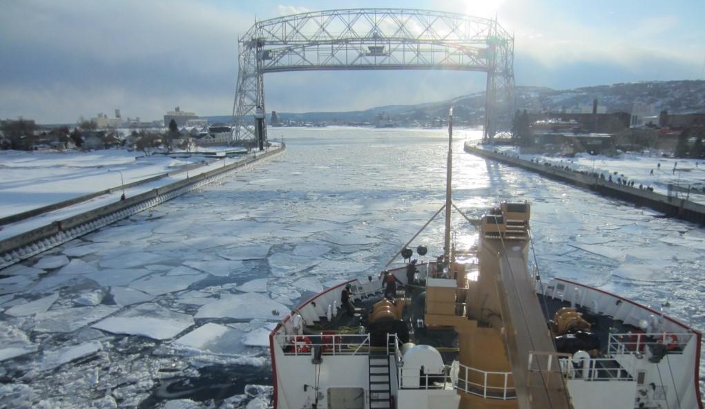
[U.S. Coast Guard Cutter Mackinaw is an icebreaking vessel on the Great Lakes that assists in keeping channels and harbors open to navigation. Here, the USCGC Mackinaw arrives in Duluth via Lake Superior on March 24, 2014. Credit: NOAA]
[Written by NOAA] NOAA scientists project the maximum Great Lakes ice cover for 2021 will be 30 percent, higher than last year’s maximum of 19.5 percent, but part of a long-term pattern of declining ice cover likely driven by climate change. The maximum typically occurs between mid-February and early March.
The 30-percent projected maximum ice cover forecast for this winter is an average of maximum ice coverage across the five lakes.
Using an improved forecast system, scientists at the Great Lakes Environmental Research Laboratory this year will update seasonal ice cover projections twice a month. Each iteration will take into account the most recent surface air temperature data leading to a more accurate forecast.
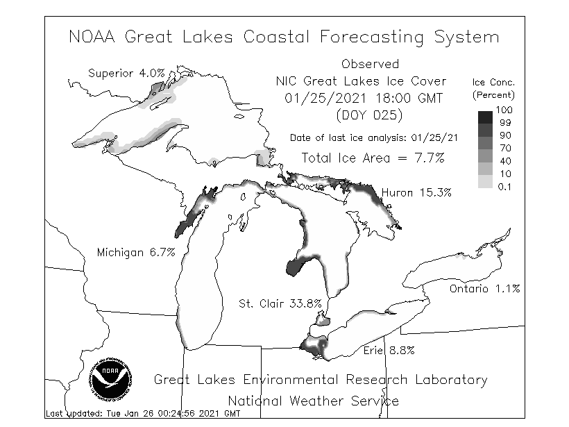 [Great Lakes ice coverage as of the evening of January 25th. From NOAA]
The experimental seasonal projections can provide general information to assist shippers, commercial and recreational vessel operators, anglers, coastal managers and the general public who live, work and recreate on and around our nation’s largest freshwater lakes.
“Great Lakes ice cover often swings back and forth between higher and lower levels with each new year,” said Jia Wang, ice climatologist at NOAA GLERL. “Global climate patterns such as El Nino play a major role in driving these changes. But if annual cycles are removed, a long-term trend is visible showing that overall ice cover has been declining by five percent per decade based on 1973-2020 data.”
Wang attributes the decline to human-caused climate change, primarily rising atmospheric temperature.
[Great Lakes ice coverage as of the evening of January 25th. From NOAA]
The experimental seasonal projections can provide general information to assist shippers, commercial and recreational vessel operators, anglers, coastal managers and the general public who live, work and recreate on and around our nation’s largest freshwater lakes.
“Great Lakes ice cover often swings back and forth between higher and lower levels with each new year,” said Jia Wang, ice climatologist at NOAA GLERL. “Global climate patterns such as El Nino play a major role in driving these changes. But if annual cycles are removed, a long-term trend is visible showing that overall ice cover has been declining by five percent per decade based on 1973-2020 data.”
Wang attributes the decline to human-caused climate change, primarily rising atmospheric temperature.
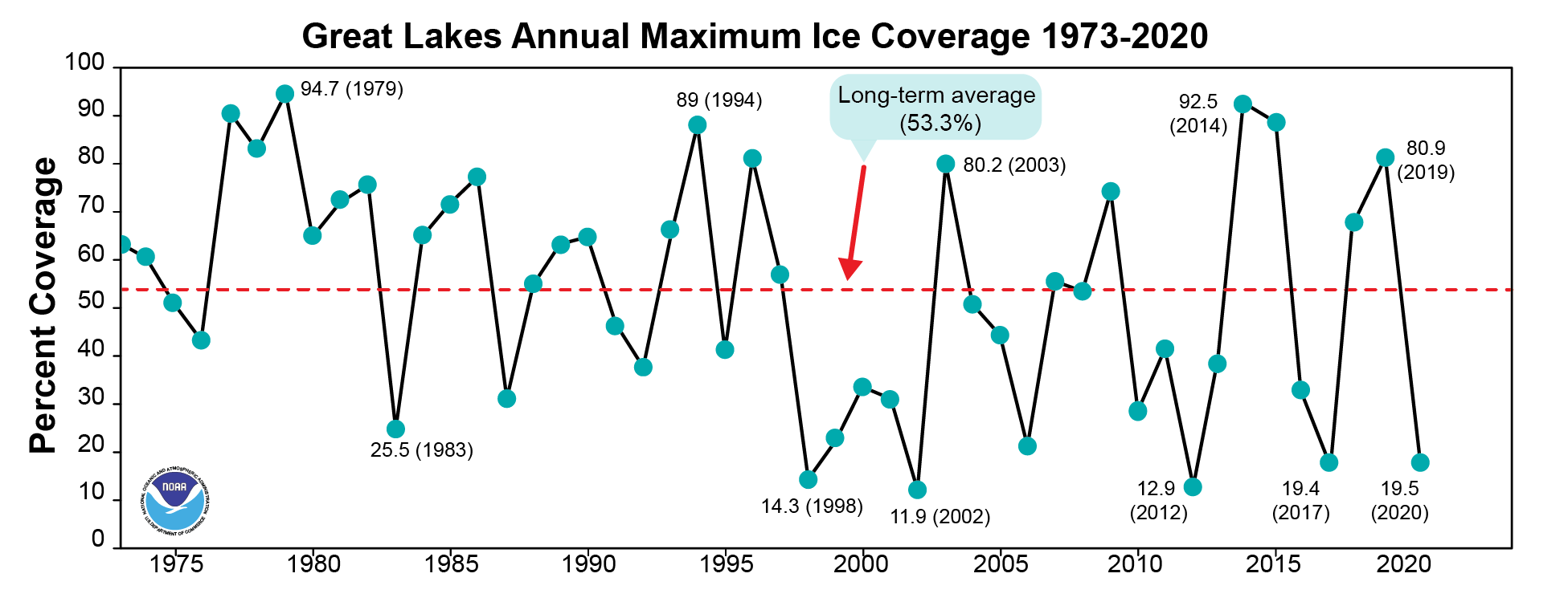 [Great Lakes ice cover experiences a great deal of year-to-year variability. This image illustrates the long-term mean in annual maximum ice cover for 1973-2020. From NOAA]
The 2021 maximum ice cover prediction of 30 percent is significantly lower than the long-term average maximum coverage of 53 percent. The 2021 prediction is higher than the 2017 and 2020 maximums (both about 19.5 percent) and much lower than the 2018 maximum of 70 percent and the 2019 maximum of 81percent.
NOAA GLERL produces ice projections using a model that ingests statistical ice data as well as data on global air circulation patterns. NOAA GLERL research has shown that the year-to-year variability of Great Lakes ice cover is heavily influenced by four large-scale climate patterns referred to as teleconnections: the North Atlantic Oscillation (NAO), the Atlantic Multidecadal Oscillation (AMO), the El Nino/Southern Oscillation (ENSO) and the Pacific Decadal Oscillation (PDO). These patterns impact Great Lakes regional climate and ice cover by influencing the location of the westerly jet stream over North America.
GLERL produces ice projections for the five lakes taken together as well as individual lakes. Each lake has a different pattern of ice cover with Lake Erie often experiencing the highest percentage of ice cover because its shallow water accelerates freezing.
[Great Lakes ice cover experiences a great deal of year-to-year variability. This image illustrates the long-term mean in annual maximum ice cover for 1973-2020. From NOAA]
The 2021 maximum ice cover prediction of 30 percent is significantly lower than the long-term average maximum coverage of 53 percent. The 2021 prediction is higher than the 2017 and 2020 maximums (both about 19.5 percent) and much lower than the 2018 maximum of 70 percent and the 2019 maximum of 81percent.
NOAA GLERL produces ice projections using a model that ingests statistical ice data as well as data on global air circulation patterns. NOAA GLERL research has shown that the year-to-year variability of Great Lakes ice cover is heavily influenced by four large-scale climate patterns referred to as teleconnections: the North Atlantic Oscillation (NAO), the Atlantic Multidecadal Oscillation (AMO), the El Nino/Southern Oscillation (ENSO) and the Pacific Decadal Oscillation (PDO). These patterns impact Great Lakes regional climate and ice cover by influencing the location of the westerly jet stream over North America.
GLERL produces ice projections for the five lakes taken together as well as individual lakes. Each lake has a different pattern of ice cover with Lake Erie often experiencing the highest percentage of ice cover because its shallow water accelerates freezing.
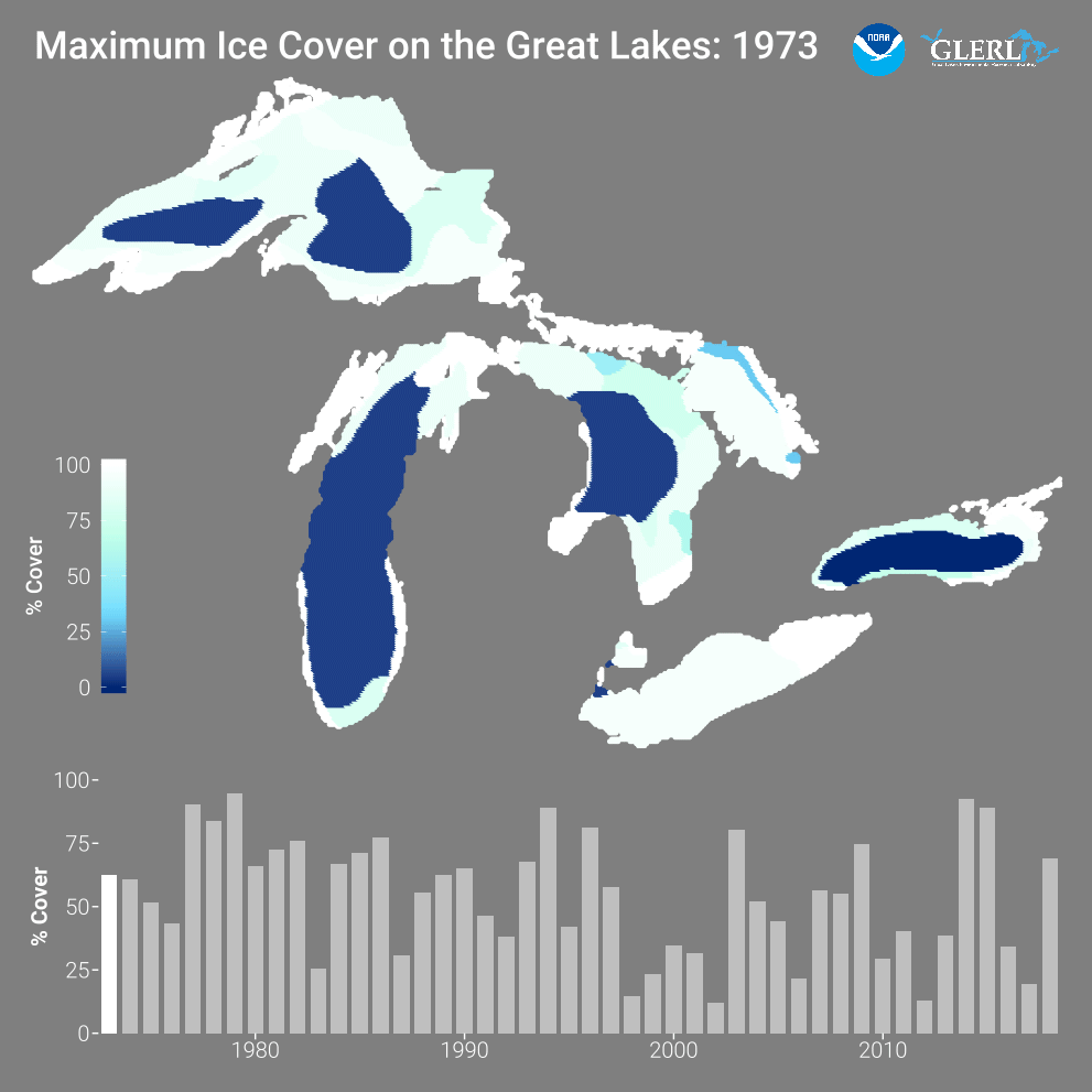 [Great Lakes ice cover experiences a great deal of year-to-year variability. This movie shows the maximum ice cover for 1973-2019.]
The 30-percent projected maximum ice cover forecast for this winter is an average of maximum ice coverage across the five lakes. Here are maximum ice cover projections for each lake:
[Great Lakes ice cover experiences a great deal of year-to-year variability. This movie shows the maximum ice cover for 1973-2019.]
The 30-percent projected maximum ice cover forecast for this winter is an average of maximum ice coverage across the five lakes. Here are maximum ice cover projections for each lake:
[Great Lakes ice coverage as of the evening of January 25th. From NOAA]
The experimental seasonal projections can provide general information to assist shippers, commercial and recreational vessel operators, anglers, coastal managers and the general public who live, work and recreate on and around our nation’s largest freshwater lakes.
“Great Lakes ice cover often swings back and forth between higher and lower levels with each new year,” said Jia Wang, ice climatologist at NOAA GLERL. “Global climate patterns such as El Nino play a major role in driving these changes. But if annual cycles are removed, a long-term trend is visible showing that overall ice cover has been declining by five percent per decade based on 1973-2020 data.”
Wang attributes the decline to human-caused climate change, primarily rising atmospheric temperature.
[Great Lakes ice cover experiences a great deal of year-to-year variability. This image illustrates the long-term mean in annual maximum ice cover for 1973-2020. From NOAA]
The 2021 maximum ice cover prediction of 30 percent is significantly lower than the long-term average maximum coverage of 53 percent. The 2021 prediction is higher than the 2017 and 2020 maximums (both about 19.5 percent) and much lower than the 2018 maximum of 70 percent and the 2019 maximum of 81percent.
NOAA GLERL produces ice projections using a model that ingests statistical ice data as well as data on global air circulation patterns. NOAA GLERL research has shown that the year-to-year variability of Great Lakes ice cover is heavily influenced by four large-scale climate patterns referred to as teleconnections: the North Atlantic Oscillation (NAO), the Atlantic Multidecadal Oscillation (AMO), the El Nino/Southern Oscillation (ENSO) and the Pacific Decadal Oscillation (PDO). These patterns impact Great Lakes regional climate and ice cover by influencing the location of the westerly jet stream over North America.
GLERL produces ice projections for the five lakes taken together as well as individual lakes. Each lake has a different pattern of ice cover with Lake Erie often experiencing the highest percentage of ice cover because its shallow water accelerates freezing.
[Great Lakes ice cover experiences a great deal of year-to-year variability. This movie shows the maximum ice cover for 1973-2019.]
The 30-percent projected maximum ice cover forecast for this winter is an average of maximum ice coverage across the five lakes. Here are maximum ice cover projections for each lake:
-
Lake Superior: 30%
-
Lake Michigan: 23%
-
Lake Huron: 39%
-
Lake Erie: 63%
-
Lake Ontario: 7%
All Weather News
More

More Storms for the East Through Monday
A low-pressure system that moved through the
3 Aug 2026 12:20 PM


After Reaching Category 5, Genevieve Weakens in the Pacific
PacificGenevieve formed last Friday south of
3 Aug 2026 12:30 AM

Flooding, Severe Storms Target the Midwest Again
After an active week of storms across the nor
1 Aug 2026 1:40 AM

Flooding Risk Increases as Heavy Rain Targets the Tri-State Area
Tuesday, heavy rainfall moved across the Nort
30 Jul 2026 12:25 AM