NOAA Research Holds Promise of Predicting Snowpack Months Before Snow Falls
Special Stories
25 Jan 2018 12:53 PM
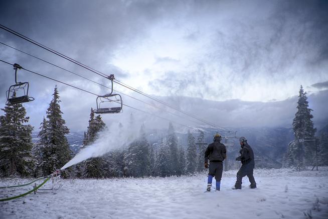
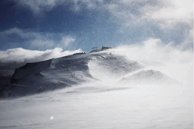
[Making snow at Copper Mountain]
From NOAA by Michon Scott and Rebecca Lindsey
In the western United States, residents rely on winter’s snow for summer’s water. A string of skimpy snowpacks between 2012 and 2015 in many Western mountain ranges curtailed municipal water use, threatened endangered species, dried out crops and rangeland, and boosted the risk of wildfire. Better snowpack forecasts might have helped the West prepare for what was coming, but seasonal snowpack is notoriously difficult to predict.
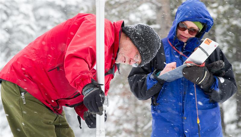 [Frank Gehrke, left, of the California Department of Water Resources, measures snow levels in the mountains of El Dorado County, California. Credit: John Chacon / California Department of Water Resources.]
A recent “hindcast” experiment led by Sarah Kapnick of NOAA’s Geophysical Fluid Dynamics Laboratory shows climate experts are making progress, though. This pair of maps shows average March snowpack between 2012-2015: predictions made on July 1 of each year (left) compared to observations (right). The maps show snow water equivalent: the amount of liquid water a snowpack would yield if it were all to melt at once. Places where the water content of the snowpack was above average are blue; places where it was below average are brown.
[Frank Gehrke, left, of the California Department of Water Resources, measures snow levels in the mountains of El Dorado County, California. Credit: John Chacon / California Department of Water Resources.]
A recent “hindcast” experiment led by Sarah Kapnick of NOAA’s Geophysical Fluid Dynamics Laboratory shows climate experts are making progress, though. This pair of maps shows average March snowpack between 2012-2015: predictions made on July 1 of each year (left) compared to observations (right). The maps show snow water equivalent: the amount of liquid water a snowpack would yield if it were all to melt at once. Places where the water content of the snowpack was above average are blue; places where it was below average are brown.
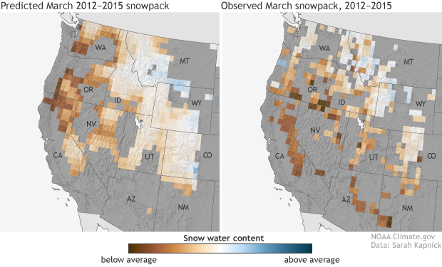 The maps show that the predictions from the experiment’s 50-kilometer resolution model matched many of the regional features of the 2012-2015 snow drought, especially the southwest-northeast gradient: below-average snowpack in the west-southwest (Oregon’s Cascade Range, the Sierra Nevada of northern California, Utah’s Wasatch Range) and above-average snowpack in small areas of the Northern Rockies in Montana and Wyoming.
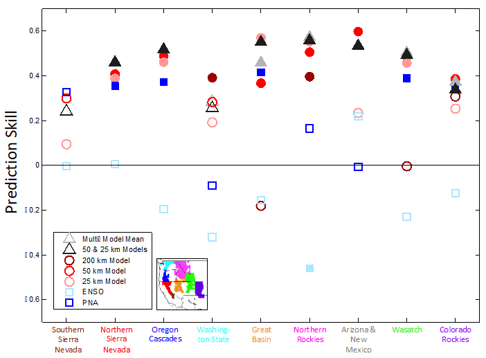 [Mountain range March snowpack prediction skill made on July 1st. Predictions made using dynamical global climate models (triangles, circles) and statistical climate index observations (squares). Statistically significant predictions are shown by filled symbols (higher values have more skill). Inset provided for ranges in highest resolution model, the 200 km model has no ranges for: Northern and Southern Sierra Nevada, Oregon Cascades, or AZ &NM.]
These maps are only a subset of all the tests the team ran in the experiment—which took months to run on NOAA’s Gaia and Theia supercomputers. They also tested a less detailed, 200-kilometer model and a more detailed, 25-kilometer model. They tested the models’ ability to simulate the 2012-2015 snow drought and their ability to predict the 36-year average snowpack between 1981-2016. They scored each model’s individual performance in each mountain range, and they tested whether averaging models together would improve the results.
All of these tests reflect this experiment’s main purpose as a path-finding mission: to see if any of the GFDL group’s current models could get snowpack estimates that were even in the right ballpark. Running solo, the 50-kilometer model performed the best in the most mountain ranges. In individual ranges, however, sometimes the best result came from averaging different models’ outputs.
[Mountain range March snowpack prediction skill made on July 1st. Predictions made using dynamical global climate models (triangles, circles) and statistical climate index observations (squares). Statistically significant predictions are shown by filled symbols (higher values have more skill). Inset provided for ranges in highest resolution model, the 200 km model has no ranges for: Northern and Southern Sierra Nevada, Oregon Cascades, or AZ &NM.]
These maps are only a subset of all the tests the team ran in the experiment—which took months to run on NOAA’s Gaia and Theia supercomputers. They also tested a less detailed, 200-kilometer model and a more detailed, 25-kilometer model. They tested the models’ ability to simulate the 2012-2015 snow drought and their ability to predict the 36-year average snowpack between 1981-2016. They scored each model’s individual performance in each mountain range, and they tested whether averaging models together would improve the results.
All of these tests reflect this experiment’s main purpose as a path-finding mission: to see if any of the GFDL group’s current models could get snowpack estimates that were even in the right ballpark. Running solo, the 50-kilometer model performed the best in the most mountain ranges. In individual ranges, however, sometimes the best result came from averaging different models’ outputs.
 [From the Sierra Nevada Mountains. Credit: Flickr user Perfect Zero, CC BY 2.0.]
In the southern Sierra Nevada, however, nothing worked. Beyond their ability to successfully predict observed declines in snowpack due to long-term warming, the models had no skill in predicting March snowpack in this range eight months in advance. So the team plans to test whether predictions with shorter lead times, say 3 months out, or a new model configuration—new equations representing the models’ physics, or models with even more detail than 25-kilometers—might be more successful.
Even failure is useful, though. All those differences in skill are clues to which of the model’s “rules” (the equations of physics and thermodynamics that govern how the ocean, land, and atmosphere interact in the virtual world) and which kinds of input data are most important for snowpack prediction. These clues will help Kapnick and her team make revisions to the models—upgrades that they hope will soon turn it into a practical tool for water users and managers in the snow-dependent West.
For more information: GFDL and NOAA Research
Edited for WeatherNation by Meteorologist Mace Michaels
[From the Sierra Nevada Mountains. Credit: Flickr user Perfect Zero, CC BY 2.0.]
In the southern Sierra Nevada, however, nothing worked. Beyond their ability to successfully predict observed declines in snowpack due to long-term warming, the models had no skill in predicting March snowpack in this range eight months in advance. So the team plans to test whether predictions with shorter lead times, say 3 months out, or a new model configuration—new equations representing the models’ physics, or models with even more detail than 25-kilometers—might be more successful.
Even failure is useful, though. All those differences in skill are clues to which of the model’s “rules” (the equations of physics and thermodynamics that govern how the ocean, land, and atmosphere interact in the virtual world) and which kinds of input data are most important for snowpack prediction. These clues will help Kapnick and her team make revisions to the models—upgrades that they hope will soon turn it into a practical tool for water users and managers in the snow-dependent West.
For more information: GFDL and NOAA Research
Edited for WeatherNation by Meteorologist Mace Michaels
[Frank Gehrke, left, of the California Department of Water Resources, measures snow levels in the mountains of El Dorado County, California. Credit: John Chacon / California Department of Water Resources.]
A recent “hindcast” experiment led by Sarah Kapnick of NOAA’s Geophysical Fluid Dynamics Laboratory shows climate experts are making progress, though. This pair of maps shows average March snowpack between 2012-2015: predictions made on July 1 of each year (left) compared to observations (right). The maps show snow water equivalent: the amount of liquid water a snowpack would yield if it were all to melt at once. Places where the water content of the snowpack was above average are blue; places where it was below average are brown.
The maps show that the predictions from the experiment’s 50-kilometer resolution model matched many of the regional features of the 2012-2015 snow drought, especially the southwest-northeast gradient: below-average snowpack in the west-southwest (Oregon’s Cascade Range, the Sierra Nevada of northern California, Utah’s Wasatch Range) and above-average snowpack in small areas of the Northern Rockies in Montana and Wyoming.
[Mountain range March snowpack prediction skill made on July 1st. Predictions made using dynamical global climate models (triangles, circles) and statistical climate index observations (squares). Statistically significant predictions are shown by filled symbols (higher values have more skill). Inset provided for ranges in highest resolution model, the 200 km model has no ranges for: Northern and Southern Sierra Nevada, Oregon Cascades, or AZ &NM.]
These maps are only a subset of all the tests the team ran in the experiment—which took months to run on NOAA’s Gaia and Theia supercomputers. They also tested a less detailed, 200-kilometer model and a more detailed, 25-kilometer model. They tested the models’ ability to simulate the 2012-2015 snow drought and their ability to predict the 36-year average snowpack between 1981-2016. They scored each model’s individual performance in each mountain range, and they tested whether averaging models together would improve the results.
All of these tests reflect this experiment’s main purpose as a path-finding mission: to see if any of the GFDL group’s current models could get snowpack estimates that were even in the right ballpark. Running solo, the 50-kilometer model performed the best in the most mountain ranges. In individual ranges, however, sometimes the best result came from averaging different models’ outputs.
[From the Sierra Nevada Mountains. Credit: Flickr user Perfect Zero, CC BY 2.0.]
In the southern Sierra Nevada, however, nothing worked. Beyond their ability to successfully predict observed declines in snowpack due to long-term warming, the models had no skill in predicting March snowpack in this range eight months in advance. So the team plans to test whether predictions with shorter lead times, say 3 months out, or a new model configuration—new equations representing the models’ physics, or models with even more detail than 25-kilometers—might be more successful.
Even failure is useful, though. All those differences in skill are clues to which of the model’s “rules” (the equations of physics and thermodynamics that govern how the ocean, land, and atmosphere interact in the virtual world) and which kinds of input data are most important for snowpack prediction. These clues will help Kapnick and her team make revisions to the models—upgrades that they hope will soon turn it into a practical tool for water users and managers in the snow-dependent West.
For more information: GFDL and NOAA Research
Edited for WeatherNation by Meteorologist Mace MichaelsAll Weather News
More
Severe Storms Target the Midwest to the Northeast
UPPER MIDWEST - Dangerous tornadoes have alre
28 Jul 2026 1:45 AM

Tropics: Fausto Heads towards Hawaii; Genevieve Cat 4 Hurricane
PacificHurricane Fausto continues to track we
28 Jul 2026 1:45 AM


Southeast Flood Risk Lingers Near Stalled Front
A stalled boundary over the Southeast will ke
25 Jul 2026 10:55 AM

Another Round of Storms Targets the Northeast
Tuesday brought severe weather again across p
23 Jul 2026 1:15 AM

Another Round of Severe Weather for the Upper Midwest and Great Lakes
The upper-level low train continues to keep t
21 Jul 2026 1:45 AM